Kayamkulam

Last updated

Kayamkulam
Irravipattanam
Municipality
Krishnapuram palace1.jpg
Krishnapuram Palace
India Kerala location map.svg
Red pog.svg
Kayamkulam
Location in Kerala, India
India location map.svg
Red pog.svg
Kayamkulam
Kayamkulam (India)
Coordinates: 9°10′19″N76°30′04″E / 9.172°N 76.501°E / 9.172; 76.501 Coordinates: 9°10′19″N76°30′04″E / 9.172°N 76.501°E / 9.172; 76.501
CountryFlag of India.svg  India
State Kerala
District Alappuzha
Government
  BodyKayamkulam Municipality
  MLA U Prathiba
Area
  Total21.79 km2 (8.41 sq mi)
Population
 (2011) [1]
  Total68,634
  Density3,100/km2 (8,200/sq mi)
Languages
  Official Malayalam, English
Time zone UTC+5:30 (IST)
PIN
690502
Telephone code+91-479
Vehicle registration KL-29
Nearest city Kollam (37 km), Alappuzha (47 km),Haripad(13 km),
Sex ratio 0.944 /
Literacy81.76%

Kayamkulam is a town and municipality in the Onattukara region of Alappuzha district in Kerala. It is the second biggest town in Alappuzha district. It is located on the western coast of India, and was an ancient maritime trading center.Kayamkulam is part of the Karthikappally tehsil. Krishnapuram Palace is located nearby.

Contents

Coconut plantations Coconut tree orchard.JPG
Coconut plantations

History

Kayamkulam was a medieval feudal kingdom known as Odanad ruled by the Kayamkulam rajas. Maha Raja Marthanda Varma (1706–58) conquered Kayamkulam and annexed its territories to Travancore.

Tourist attractions

The Krishnapuram Palace, built in the 18th century, now functions as a museum. Constructed in typical Keralan-style architecture, it has the largest mural painting in Kerala. [2] The palace museum houses the Kayamkulam double-edged sword. [3]

The Kayamkulam Boat Race [4] is held on the fourth Saturday of August every year. [5] Chinese fishing nets can be found on the banks of the lagoon. Veliyaazheekal is a beach at Arattupuzha panchayat in Kayamkulam.The main attraction in this place bow string arch Bridge (biggest one of South India).

Transport

Kayamkulam City Bus Stand Kayamkulam.jpg
Kayamkulam City Bus Stand

Roads

NH 66 passes through Kayamkulam, connecting it to the major cities Alappuzha, Kochi, Thiruvananthapuram, Thrissur, Kollam, Palakkad and Nagercoil. The Kayamkulam–Punalur road is a major road connecting it to major city's in east sengotai, Tenkasi , Thirunelveli via Pettah parts of the Tamil Nadu state. The KSRTC bus station is located near the national highway.

Railways

Kayamkulam Junction railway station is a major railway junction located 1.5 km (0.93 mi) from the town on the Kayamkulam–Punalur road.

Kayamkulam Railway Junction Kayamkulam Railway Station.jpg
Kayamkulam Railway Junction

Demographics

According to the 2001 Census of India, [6] Kayamkulam had a population of 65,299. Males constituted 49% of the population and females 51%. Kayamkulam had an average literacy rate of 82%, higher than the national average of 59.5%. Male literacy was 84%, and female literacy is 79%. In Kayamkulam, 11% of the population was under 6 years of age.

YearMaleFemaleTotal PopulationChangeReligion (%)
HinduMuslimChristianSikhsBuddhistJainOther religions and persuasionsReligion not stated
2001 [7] 31,99733,30265,299-55.7836.267.92000.0100.03
2011 [8] 32,78435,85068,634+5.1%53.3039.077.320.010.0100.010.28

Civic administration

Kayamkulam Assembly Constituency is part of Alappuzha. [9]

Educational and research institutes

The Central Coconut Research Station (CCRS) was established in 1948 as a field station of the Agricultural Research Laboratory. Presently, it is a regional station of the Central Plantation Crops Research Institute (CPCRI). [10]

Onattukara Regional Agricultural Research Station , Kayamkulam is located in the Kayamkulam Municipality of Alappuzha District, one kilometer east of Kayamkulam town, on the northern side of Kayamkulam - Punalur road. The station was established in the year 1937 under the erstwhile University of Travancore. It was subsequently transferred to the Department of Agriculture in 1958 and continued to function under it till it became a part of the KAU on 07.02.72. I n April, 2000, this Station was upgraded to the status of RARS (Onattukara Region).

KPAC drama troupe

Kerala People's Arts Club (KPAC) is a theatrical movement in Kayamkulam, Kerala. It was formed in the 1950s by a group of individuals that had close ties with the leftist parties of Kerala.

KPAC emblem KPAC Emblem.jpg
KPAC emblem

In 1951 KPAC staged its first drama, Ente Makananu Sari (transl."My Son is Right"), whose songs were written by Punaloor Balan. Its second drama Ningalenne Communistakki (transl."You Made Me a Communist") was first performed in 1952. The success of Ningalenne Communistakki brought KPAC to the forefront of a powerful people's theatre movement in Kerala. [11]

KPAC played a significant role in popularising the Communist Party in Kerala through its dramas, road shows and kathaprasangams (story telling). [12]

Power plant

The Rajiv Gandhi Combined Cycle Power Plant is a combined cycle power plant located in Cheppad, Haripad, Alappuzha district, Kerala.

Notable people

See also

Related Research Articles

<span class="mw-page-title-main">Alappuzha district</span> District in Kerala, India

Alappuzha district, is one of the 14 districts in the Indian state of Kerala. It was formed as Alleppey district on 17 August 1957, the name of the district being changed to Alappuzha in 1990, and is the smallest district of Kerala. Alleppey town, the district headquarters, was renamed Alappuzha in 2012, even though the anglicised name is still commonly used to describe the town as well as the district.

<span class="mw-page-title-main">Kottayam district</span> District in Kerala, India

Kottayam, is one of 14 districts in the Indian state of Kerala. Kottayam district comprises six municipal towns: Kottayam, Changanassery, Pala, Erattupetta, Ettumanoor, and Vaikom. It is the only district in Kerala that neither borders the Arabian Sea nor any other states.

<span class="mw-page-title-main">Vaikom</span> Municipality in Kerala, India

Vaikom, IPA: [ʋɐjkːɐm], is a municipal town and a capital town of Vaikom Taluk, situated in the northwest of Kottayam district in the state of Kerala, India. The town is also noted for its role in the Indian independence movement for being the venue of Vaikom Satyagraham, a civil rights movement aimed at securing freedom of movement for all sections of society through the public roads leading to the Vaikom Shiva Temple.

<span class="mw-page-title-main">Mavelikkara</span> Town in Kerala, India

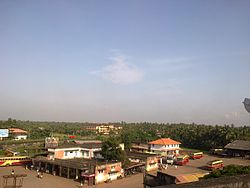
Mavelikkara is a taluk and municipality in the Onattukara region of Alappuzha district in the Indian state of Kerala. Located in the southern part of the district on the banks of the Achankovil River.

Kollam district, is one of 14 districts of the state of Kerala, India. The district has a cross-section of Kerala's natural attributes; it is endowed with a long coastline, a major Laccadive Sea seaport and an inland lake. The district has many water bodies. Kallada River is one among them, and the east side land of river is East Kallada and the west side land is West Kallada.

Odanad was a feudal state in late medieval Kerala. It was established in the 11th century, and disestablished in 1746 when it became part of Travancore after Venad King Marthanda Varma's northern expedition. The last king of Odanad was King Kotha Varma. At the time of its dissolution, it was composed of the present-day taluks of Mavelikkara, Karthikapally, Chenganur in the Alappuzha district and Karunagapally in the Kollam district. In the 15th century, the capital of Odanad was moved from Kandiyoor-Muttom, Mavelikkara to Eruva and Krishnapuram, near Kayamkulam, which led to the state being called Kayamkulam. After this shift, Kayamkulam became the commercial centre of Odanad, while Mavelikkara remained its cultural centre. Odanad was controlled by Nair lords, among whom the ruler of Kayamkulam was the most prominent.

<span class="mw-page-title-main">Adoor</span> Municipality in Kerala, India

Adoor is a Municipality in Pathanamthitta district of Kerala State, India. It is the headquarters of Adoor Taluk and Adoor Revenue Division.

<span class="mw-page-title-main">Alappuzha</span> City in Andhra Pradesh, India

Alappuzha or Alleppey is the administrative headquarters of Alappuzha district in state of Kerala, India. The Backwaters of Alappuzha are one of the most popular tourist attractions in India which attracts millions of domestic and international tourists.

<span class="mw-page-title-main">Kottayam</span> City in Kerala, India

Kottayam, IPA: [koːʈːɐjɐm] is a city in the Indian state of Kerala. Flanked by the Western Ghats on the east and the Vembanad Lake and paddy fields of Kuttanad on the west. It is the district headquarters of Kottayam district, located in south-west Kerala. Kottayam is located in the basin of the Meenachil River at an average elevation of 3 metres (9.8 ft) above sea level, and has a moderate climate. It is located approximately 155 kilometres (96 mi) north of the state capital Thiruvananthapuram.

<span class="mw-page-title-main">Chengannur</span> Municipal Town in Kerala, India

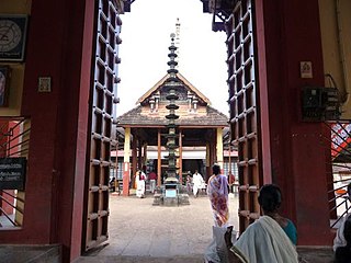
Chengannur is a Town and Municipality in the Alappuzha district of Kerala State, India. It is located in the extreme eastern part of the Alappuzha district, on the banks of Pamba River. Chengannur is Known as The gateway of Sabarimala. Chengannur is 117 kilometres (73 mi) north of the state capital Thiruvananthapuram on the MC Road. Chengannur is connected to Kollam and Kottayam by NH 183. Chengannur is noted for the Chengannur Mahadeva Temple and its Old Syrian Church of the ancient Syrian Christian community. Chengannur is also a major destination of Sabarimala pilgrims known as the Gateway of Sabarimala.

<span class="mw-page-title-main">Haripad</span> Town/Municipality in Kerala, India

Haripad is a Municipality in Onattukara region of Alappuzha District, Kerala, India located between Alappuzha and Kollam on the National Highway 66. Haripad is bordered on the east by Pallippad, Veeyapuram and Karuvatta to the north, Kumarapuram and Karthikappally to the West, and on the south by Cheppad. It is known as the land of art, artists, land of snake boats, land of music, dance and drama. It is also popularly known as Kshetranagari in which Haripad Temple being the chief one among them.One of the largest thermal power plants in Kerala, the Rajiv Gandhi Combined Cycle Power Plant run by the NTPC, is situated at Haripad.

Mannar is a census town in Chengannur Taluk in Alappuzha District of Kerala state, India, on State Highway 6. It is also known as the Bell Metal Town.

<span class="mw-page-title-main">Oachira</span> Town in Kerala, India

Oachira or Ochira is an ancient temple town located 32 km away from Kollam city in Karunagappally taluk, Kollam district in Kerala, India.

Karunagappally is a municipality in the Kollam district of Kerala, India. It is 24 km north of Kollam and 60 km (37 mi) south of Alappuzha. Karunagappally taluk consists of Alappad, Ochira, Adinad, Karunagappally, Thazhava, Pavumba, Thodiyoor, Kallalibhagom, Thevalakkara, Chavara, Neendakara, Clappana, Kulasekharapuram, Thekkumbhagam, Ayanivelikulangara, Panmana, Ponmana and Vadakumthala. The taluk is bound on the north by Kayamkulam, on the east by Kunnathur taluk, on the south by Kollam and on the west by the Arabian Sea. It is one of the fastest developing towns in Kerala and is part of Kollam metropolitan area.

<span class="mw-page-title-main">Kerala People's Arts Club</span> Theatrical movement in Kerala

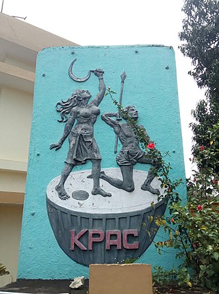
Kerala People's Arts Club, abbreviated as KPAC, is a theatrical movement in Kayamkulam, Kerala, India. It was formed in the 1950s by a group of individuals having close ties with the Communist Party of India in Kerala. KPAC was very influential in popularising the Communist movement in Kerala.

<span class="mw-page-title-main">Thoppil Bhasi</span> Playwright

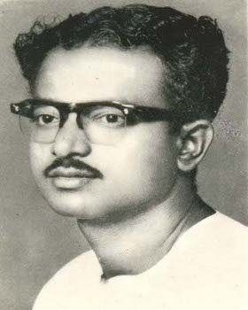
Thoppil Bhaskara Pillai, known as Thoppil Bhasi was an Indian Malayalam-language playwright, screenwriter, and film director. He was associated with the communist movement in Kerala and his play Ningalenne Communistakki is considered to be a groundbreaking event in the history of Malayalam theatre.

<span class="mw-page-title-main">Krishnapuram, Alappuzha district</span> Village in Kerala, India

Krishnapuram is a village in Alappuzha district in the Indian state of Kerala.

<span class="mw-page-title-main">Muthukulam</span> Village in Kerala, India

Muthukulam is backwater village near Haripad in Alappuzha district in the Indian state of Kerala.

<span class="mw-page-title-main">Nooranad</span> Town in Kerala, India

Nooranad is a developing town in Mavelikkara taluk of Alappuzha district in the Indian state of Kerala. It is located at a distance of 8 Km south-west of Pandalam, in Kayamkulam route. Padanilam is the cultural centre of Nooranad region. The Padanilam Parabrahma Temple, known for the biggest Shivarathri Kettukazhcha in Kerala, is situated in Nooranad. Nooranad is declared by the Government of Kerala as the Nandikesha Paithruka Gramam due to its importance in Kettukala making, which is an icon of Onattukara region of Central Travancore. Nooranad is also known as Pakshi Gramam of kerala.

<span class="mw-page-title-main">Krishnapuram Palace</span> Palace in South kerala

The Krishnapuram Palace is a palace and museum located in Kayamkulam near Alappuzha in Alappuzha district, Kerala in southwestern India. It was built in the 18th century by Anizham Thirunal Marthanda Varma, the Travancore kingdom. It is built in the architectural style of Kerala with gabled roof, narrow corridor and dormer windows, near the Krishnaswamy Temple at Krishnapuram.

References

  1. "Kerala (India): Districts, Cities and Towns - Population Statistics, Charts and Map".
  2. Lonely Planet Things to do in Southern Kerala by Lonely Planet travellers.
  3. Department of Archeology Website Archived 2011-01-22 at the Wayback Machine .
  4. First Kayamkulam boat race.
  5. Kerala boat races Archived 28 June 2012 at the Wayback Machine .
  6. "Census of India 2001: Data from the 2001 Census, including cities, villages and towns (Provisional)". Census Commission of India. Archived from the original on 16 June 2004. Retrieved 1 November 2008.
  7. Census India 2001.
  8. Census India 2011.
  9. "Assembly Constituencies - Corresponding Districts and Parliamentary Constituencies" (PDF). Kerala. Election Commission of India. Archived from the original (PDF) on 4 March 2009. Retrieved 20 October 2008.
  10. "ICAR-Central Plantation Crops Research Institute".
  11. "Frontline article". Archived from the original on 30 December 2001. Retrieved 2 October 2016.{{cite web}}: CS1 maint: unfit URL (link)
  12. "First Ministry of Kerala Government". Archived from the original on 2 October 2008. Retrieved 2 October 2016.