This article needs additional citations for verification .(July 2016) |
Tribes Perception for Agriculture and Rural House Hold Food In-security in Kelafo Woreda, Gode Zone in Somali Region Dharmendra Kumar Dube* School of Natural Resource Management and Environmental Sciences,Haramaya University, Ethiopia R Uttama Reddy** Abraha Girmay School of Geography and Environmental Studies, Haramaya University, Ethiopia Abstract Present study is on the rural household food in security in the Kelafo woreda of Somali Regional State of Ethiopia. Situated on the Eastern tip of the country, the area has tough arid climate, almost flat terrain with extremely sparse population and a predominant pastoral economy. Food security is an acute problem in this highly remote and politically sensitive region close to Somalia. The area suffers with acute food insecurity and so the dependency on FAO food program is very high. Factors affecting food security is the prime concern of this study. Following the FAO (2012-13) food security/ insecurity classification, the study area was divided into food secured and food in secured kebeleys. Both random and non random sampling techniques were used for the selection of households from food secured and in secured kebeles. A descriptive survey method was used. Questionnaire, interview, field observations and focus group discussion were the main tool used for collation of information. Descriptive statistical techniques were used for the data analysis and findings were displayed by statistical diagrams. Besides being the conventional thought for food insecurity like arid climate, remote location and problem of civil unrest and security, a series of other important factors were also identified during study. Most of the respondents were formally illiterate and only 13.4 % children were going to the formal school. The food secured and in secured kebeles are distinctly different from each other in terms of their ethnic identity, economic activity and perception for the work ethics. The major cause for food insecurity were identified as tough climatic conditions, failure in utilizing their own crop and animal products, limited nonfarm activities, and increasing population pressure. Extreme dependency on the food supply is reflected as the adoption of non conventional food like Pasta, Macaroni and Burris as their staple food. Data shows that only 54% of households were self dependent for food, while rests were dependent on other sources. The major copping strategies opted at household level were reduction in the livestock population, fishing, sale of charcoal, change in food habit, and finally outmigration. Still two fifth of total households have no option but to depend on food aid program and borrowing from their relatives. Study recommends an extensive awareness cum teaching program to natives to change their tradition mindset for tribal superiority and work ethics, and motivate for development. Promotion of formal education, setting up a marketing system for local produce and development of irrigation from Shebelle river is must for food security of the study area. Keywords: China insurance industry, Foreign fund, Challenge 1. Introduction Food insecurity is the limited or uncertain availability of nutritionally adequate and safe foods or limited or uncertain ability to acquire acceptable foods in socially acceptable ways [1]. Food in security was taken in same way in research and discussions till 2006 when USDA introduced new specifications for the severity of hunger and food insecurity- they were – ‘Low food security’ (old label=Food insecurity without hunger): reports of reduced quality, variety, or desirability of diet. Little or no indication of reduced food intake. And ‘Very low food security’ (old label=Food insecurity with hunger): Reports of multiple indications of disrupted eating patterns and reduced food intake [2]. FAO (2015) defines undernourishment as condition in which a citizen “is not able to acquire enough food to meet the daily minimum dietary energy requirements, over a period of one year.” In that sense, for FAO, chronic undernourishment is the other name of hunger [3]. The Ethiopian economy is among the most vulnerable in Sub-Saharan Africa [4][5]. It is heavily dependent on the agricultural sector, which has suffered from recurrent droughts and extreme fluctuations of output. Ethiopia is among the poorest and most food insecure countries of the world where 44% of its population live below the national poverty line; and 46% of its population get below the minimum levels of dietary energy consumption compared with other sub-Saharan and developing countries [6]. One of the most important challenges to sustainable development in Ethiopia is food insecurity. A significant proportion of the country’s population lacks ‘access to adequate food at all times for an active and healthy life’. The food insecurity situation in the rural part of the country is appalling where about 52% of the entire rural population does not have access to adequate food [7]. In the last three decades food production in Ethiopia has never been sufficient to enable the populations to be food secure. Many Ethiopians live in conditions of chronic hunger with both a low average daily energy supply (kcal/capita/day) of 1880 and a very high (44%) prevalence of undernourishment [8]. View metadata, citation and similar papers at core.ac.uk brought to you by CORE provided by International Institute for Science, Technology and Education (IISTE): E-Journals Research on Humanities and Social Sciences www.iiste.org ISSN (Paper)2224-5766 ISSN (Online)2225-0484 (Online) Vol.7, No.1, 2017 21 Accordingly, in Ethiopia food insecurity is seen as the most important feature of development challenges. Every year, more than 4 million people, particularly in the rural areas have problems of getting enough food for themselves [9]. According to Ginjo (2000), Ethiopia is a country facing multifaceted problems such as poverty, economic stagnation, and low agricultural productivity. Adverse climate changes (drought) combined with high human population pressure, environmental, technological and institutional factors, etc, have led to a decline in land holding size per-household, soil erosion and decline in productivity [10]. And ultimate outcome of all these natural and human created problems is food insecurity- that to a country which is predominantly agrarian. The graph of population growth and the growth in the number of hungry population is going hand in hand. The FAO (2015) data are now revealing that 31.6 million Ethiopians, about a third of the nation, suffer from hunger or chronic undernourishment [3]. In general, Ethiopian government implements poverty reduction strategy (PRS). Hence, examination of food insecurity at regional, zonal or house hold levels to identify the specific characteristics, of the problem is crucial. Having this back ground, this study tries to investigate the food security situation and its factors in rural house hold in Gode zone in Somali region. The total population of the region estimated by CSA 2007 was 4,439,147. The region’s infrastructure is poorly developed and the population is ill served with the basic health and social infrastructure. The drought in 1999/2000 has dramatically affected the population in particular the pastoral communities. [11] The low lying hot and dry Somali Region with sparse population and agro pastoral type economy is one of the most affected regions in the country by the problems of recurrent droughts and famine [12]. In the study area, the economic activities are both pastoral and agro pastoral economic activities. However, they are food insecure and dependent on food aid on regular basis [13]. Somali National Regional State is one of the most marginalized and neglected regions of Ethiopia. The predominant pastoral economy largely dependent of animal husbandry and deeply attached to their economic and social mindset has a significant role to play in enhancing the problem of food insecurity. In typical tribal communities such feudal mindsets put forth a high hurdle to planners and developing agents in bringing shift in the prevailing economic setup [14]. Though, the regional governments trying its best to deal with the prevailing poverty and food insecurity situations, the success is minimal. FAO report clearly revealed that the entire Somali National Region State (SNRS) of Ethiopia falls under the chronic food insecurity zone [15].The major worry among planners and people is that, up to how long the people will depend and survive with the ration of aid; usually coming on a regular basis but when could be interrupted, nobody knows. Now, it is must for the planners, officials and scholars to work to achieve food security based on native resource base. The first step in this direction is to know and assess the factors responsible for food insecurity and attempt to solve it on sustainable basis 2. Methodology The present study followed the descriptive research design following survey method. And it involved both quantitative and qualitative data in the study. The study area was divided into food secured and food in-secured areas using the map of FAO [16]. To make effective survey, the researcher used both probability and non probability sampling technique. One kebeley each was surveyed from both food secured and food in-secured kebeley. Due to acute problem of security and insurgency, transportation, hot climate, temporal settlement and extremely poor infrastructure network the study was confined to two kebeleys only. Out of total four food secured kebeles and seven food insecured kebeles; two kebeles were purposively selected, naming Bargun (Food secured) and Deriqo (Food in secured). Following the population sampling total households 72 and 62 respectively) were surveyed. To attain the objective of the study, data were collected from both primary and secondary sources. For collection of primary data house hold survey with structured questionnaire, interviews of key resource persons, focus group discussions among farmers, and field observations using check list were employed. Though an acute unavailability of secondary data was observed yet data from all possible sources, published and unpublished were collected. For analysis of data, the descriptive statistical techniques were used. 2.1. Study Area: The Kelafo Woreda is located 95 km south of Gode zone (headquarter) and 820 km from the Somali National Region capital- Jijiga. The total distance from capital of Ethiopia (Addis Ababa) is almost 1500 km. Kelafo (Somali: Qalaafe) is bordered on the south by the Somalia, on the west by Adadle, on the northwest by Gode, on the northeast by the Korahe Zone, and on the east by Mustahil. And its astronomical location is found between 5° 40′ N and 44° 10′ E. Administratively, the woreda comprises eleven kebeles.of which two kebeles are semi urban areas, the remains are purely rural Research on Humanities and Social Sciences www.iiste.org ISSN (Paper)2224-5766 ISSN (Online)2225-0484 (Online) Vol.7, No.1, 2017 22 Figure-01: The location map of the study area. In Kelafo Woreda map, the kebeles with green color are food secured and with violet color are food in-secured kebeles (FAO 2012-13). with the absence of basic infrastructure. The wereda is labeled as malaria prune. The topography of the study are is flat and quite suitable for irrigation. The average altitude of woreda is 374meter from m.s.l. The area is found in the eastern lowlands of country. Climate is hot with high average temperature and bi modal rainfall. Due to erratic nature of rainfall, the amount of rainfall per year is below 300mm and with extreme temperature ranges from 20-450C [17]. The Shebelle River, flowing through this woreda is the life line of people, going away from it all things will be declined. Such as, economic activities, settlement pattern, availability of basic infrastructure, vegetation cover availability of water supply etc. [18]. According to the Central Statistical Agency of Ethiopia (CSA-2007), this woreda has a total population of 77,471, of whom 41,583 are men and 35,888 women. In total 11,346 p or 14.65% are urban inhabitants. 98.09% of the populations are Muslims and are from different Somali ethnic group. The remains 1% are Amhara and 0.91% are other ethnic groups. The Kelafo Woreda is inhabited by the following major Sub Somali ethnic groups: the Bah Geri and Awuluyan of the Ogaden, Hawadle and Rer Bare [11]. 3. Results and Discussions: To examine the factors responsible for the rural house hold food security the primary and secondary information were collected and analyses was done; the discussion and findings are as follows 3.1. Education Education is a power mechanism for building human capital. Adoption of technologies generated from research centers, getting knowledge and information from development agents, Research on Humanities and Social Sciences www.iiste.org ISSN (Paper)2224-5766 ISSN (Online)2225-0484 (Online) Vol.7, No.1, 2017 23 communication and protecting the right to get access to resources, reducing poverty and food insecurity are easier for literate farmers than illiterate [19]. As fig-2, depicted, most of the respondents were formally illiterate. They send their children to religious school and in- formal school, 53% and 30.6% respectively. Very few respondents were sending their children to formal school (13.4%). Further, 3% of respondents were not sending their children to school. As filed observation and key informant interview the first school was learning “kuran” every child must learn the holy ‘kuran’. After knowing “kuran” he or she must join to private school to learn English language. The reason behind is to join NGO job opportunities and to cross other countries. Unfortunately formal education is not the concern for the head of households. Due to wide gap of formal education, the children are unaware of the basic issues of environment, development and scientific advancement in agriculture and other work of life. And so the present scope to use the modern technology and economic advancement seems to be poor. 3.2. Food security situation in the study area Though overall the Kelafo woreda is a food in-secured woreda in the FAO data yet there is a inter kebele variation, which is clearly shown in Woreda map released by FAO, (Fig-01). As we observe Table-I, the food security situation in the study area was greatly varying between the two kebeles around 53.7% was food secured and 46.3% was food in secured. It is important that all the households of food secured kebeley are food secured and all the households of food in-secured kebeles are food in-secured. The key resource person’s interview also reveled that such situation are quite common in not only the kebeley but the entire Gode zone. It was also observed that the reason is not just the nearness to the water source but other factors were also found important. 3.3. Reasons for food in secured in the study area: Based on the literature review a set of options were listed and were put to the respondents. The reasons werebad weather condition, failure to properly utilize own production, depending on food aid, population pressure, limited nonfarm activities, lack of work habit, lack of know how to wards work, depending on government budget, lack of fair market etc. Table-II shows that the bad weather conditions were the prime cause for food in security. Very hot climatic conditions, very low rainfall with long dry spells make the growing period smaller and often lead for the crop failure. Due to non availability of a fair market, or storing facility the good yield of perishable crop like onion goes in vain. Respondents also expressed that the high population, which is an outcome of larger family size is also a prime factor. Limited nonfarm activity is another important reason; farmers are largely dependent on cultivation and pastoral activity only. Environmental degradation, shortage of labour, and political conflict were other minor reasons shot by the respondents. Contrary to the food in-secured kebele, the food secured kebele has different factors to share. According to the FGD participants and key informant interviews, there was food secured kebeles in the district due to, wise use of resources such as using Wabishebelle river in to farming in the form of irrigation, wise use of Research on Humanities and Social Sciences www.iiste.org ISSN (Paper)2224-5766 ISSN (Online)2225-0484 (Online) Vol.7, No.1, 2017 24 labour force in agriculture, good work habit from the lowest to the highest economic activity, active participation on non agriculture activities such as, handy craft, production of baskets, fishing, trade etc. However, there were common problems in both kebeles. Such as, problem of transportation, lack of fair market, bad weather condition, limited know how in using farm oxen, lack of fair polices towards their production and lack of expert towards what to produce, how to produce, for whom to produce and for whom to distribute their production were the common challenges to ensured food security in the study area. According to the filed observation in both farming area have the local market, most of the farmers cultivate their land with similar crops and vegetables. The market was dominated by onion and banana. The woreda is unique in the production of onion. The cost per Kg is between the range of 1-2 birr. It feeds the whole region, even up to Harar (1000 km away, price is 10 Birr/Kg). The tribal identity and their perception for work are also different. The two kebeles also vary in subtribes. The food secured kebeles are called “Eri Bare tribe” means slave, the lowest tribe, and the food in secured kebeles are called “Ogaden” means the pure Somali tribe. Still the two kebeles are not equally treated by the regional government in every governmental office or working activities. So, there is rough relationship between the two kebeles. In this situation the Eri Bare tribe people work hard and do not live with any concept of tribal superiority; in contrary to them the Ogadens live with their tribal superiority, are not so active and hardworking in agriculture activities, considering it as something below to their tribal dignity. 3.4. The current main food in the study area. The current main food in the study area, as figure-3 depicted are, maize, wheat (WFP-aid), sorghum (21.6%,17.9% and 16.4% respectively) were the major source of food And macaroni, pasta and ‘beris’ were. also additional source of food in the study area (15.8%, 14.9% and 13.4% respectively. The point here to be noted that the Maize and Sorghum are the two only food items which are cultivated locally. It shows that more than 2/3rd of the food is coming from outside. 3.4. Main source of food The main source of food in the study area was varying between the two kebeles. The situation is quite contrast. The main source of food in the food secured kebeles was their own production, while for majority of others inhabitants, their dependency are on other sources. As fig-04 shows, in general in the study area 53.7% are depending on their own food production, which are predominantly from the food secured kebeles. Whereas, the main sources of food in the poor kebeles were food aid, safety net program and borrowing from their relatives, who in total representing the 46% of the households in this study area. Here two points are quite important first, all the households of food in-secured kebele are depending upon others, either aid programs or local borrowing, and the second is that in the study are 41% of total households are depending directly on the Aid programs. This wide gap between these kebeleys are not only because of variation in their primary occupation as predominantly Research on Humanities and Social Sciences www.iiste.org ISSN (Paper)2224-5766 ISSN (Online)2225-0484 (Online) Vol.7, No.1, 2017 25 cultivation and predominantly pastoral or agro pastoral. Here their higher social status in intra and inter ethnic context is quite important, which lookdown cultivation and try to maintain their status through the traditional pastoral activity. During field observation and interaction with the local people it was found that they are not ignorant about the situation and their overall food deficiency. Their worry for the future of the food aid programs run by FAO was also reflected during FGDs. They also try to come up with some of the coping mechanism [15]. 3.5. The Role of Households in Coping Strategies According to Dagnew (1993), coping strategy is defined as a mechanism by which individual households or members in the household meet their relief and recovery needs, and adjust to risks of food shortages by themselves without outside support [19]. The house hold level efforts could be instrumental in resolving the chronic food insecurity in Ethiopia [20]. It implies a forward planning approach mainly at a household and individual level. As figure-5 depicted, most of the rural households during food shortage were selling number of live stock, food aid, fishing and borrowing grains from relatives is 24.6%, 23.1%, 17.9% and 15.8% respectively. Further, some of the respondents were selling charcoal production, consuming less food, diet change and out migration or 10.5%, 3.7%, 2.2% respectively. Here charcoal production and outmigration is a bit new and can bring a significant change on the natural and social environment of the area. Research on Humanities and Social Sciences www.iiste.org ISSN (Paper)2224-5766 ISSN (Online)2225-0484 (Online) Vol.7, No.1, 2017 26 4. Conclusion and Recommendation The present study of Kelafo Woreda in Gode Zone of the Somali National Region of Ethiopi depicts the root causes of food insecurity in the region. The woreda is being divided in to food secured and food in secured kebeleys by WFP; and the study finds distinctive variations among the attitude and actions of these kebekes. Literacy is quite low and people have a strong tendency to send their children to religious and informal schools; only one out of eight households prefers to send their children to a formal school. The causes cited for food insecurity are the bad weather conditions, failure to properly utilize their own production, non availability of fair market, nonfarm activities and the population pressure. Besides the animal produce in the form of meat and milk; Maize, Sorghum, wheat are the main crops produced and consumed, but the supply of the WFP in terms of Pasta, Macaroni and Burris are among their prime diet. Teff, the stipple food grain of Ethiopia is not consumed which is enough to show the cultural distinctness from rest of Ethiopia. The strategy adopted by the native people to cope up the food in security are the reduction in the number of animals and adopting fishing predominantly by the food secured kebeles while adopting the food Aid supply predominately by the food in secured kebeleys. Though the geophysical and climatic conditions are same for the entire region and most of them are Somali, following Muslim faith yet intra tribal variations play important here. Surprisingly the foods in secured kebeles are hailed by inferior sub tribe ‘Eri Bare’, they are hard working settled close to the river Wabishebelle and largely busy in cultivation and up to large extent progressive and ready to move forward and progress. The food in secured kebeles are settled by the high social ranking Ogaden tribe, predominately engaged in animal husbandry, conservative in their thought and having strong supercilious attitude, which make them somewhat lazy and prevent them in doing certain activity like cultivation. Based on the findings of the study following recommendations are being given for accuring food security in the region- • Bringing change in traditional attitude of tribal superiority and work ethics is the prime need for the peoples’ motivation for food security and development. To achieve this extensive awareness program is needed, which should be launched by the NGOs and Somali State government. • Extensive program for children’s formal education and in similar way an adult education program is needed. • People should be promoted and helped by the Governments and international NGOs to shift their agriculture system from pastoral to Agro-pastoral and Crop cultivation. • A systematic market should be developed where farmer could easily sale his produce (Like onion and animal produce) at fare price without the involvement of brokers. • Development of irrigation system using water of river Wabishebele is required for the development of agriculture in the area. Research on Humanities and Social Sciences www.iiste.org ISSN (Paper)2224-5766 ISSN (Online)2225-0484 (Online) Vol.7, No.1, 2017 27 References Table 1. food security situation of Households in Study area. Food security situation frequency percent Food secured 72 53.7 Food in secured 62 46.3 Total 134 100.00 Research on Humanities and Social Sciences www.iiste.org ISSN (Paper)2224-5766 ISSN (Online)2225-0484 (Online) Vol.7, No.1, 2017 28 Table 2. Reasons for food in security. Reasons for food insecurity Yes or no Frequency (n= 134) Per cent (Y+N= 100) Failure to properly utilize own production Yes 128 95.5 No 6 4.5 Limited nonfarm activities Yes 111 82.8 No 23 17.2 Tough climatic conditions Yes 133 99.3 No 1 0.75 Availability of fair market Yes 21 15.7 No 113 84.3 Labour shortage Yes 44 32.8 No 90 67.2 Environmental degradation Yes 78 58.2 No 56 41.8 Population pressure Yes 119 88.8 No 15 11.2 Conflict/ political problem Yes 43 32.1 No 91 6
Contents
- Demographics
- Notes
- FAO. United Nations Food and Agriculture Organization. The FAO Hunger Map, FAO, Rome, 2015. http://www.fao.org/hunger/en/?utm source=twitter&utm medium=social media&utm campaign (Data retrieval, 25. Dec 2016 )
Kelafo Banyaxow Au Calif, Digino bar | |
|---|---|
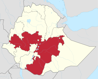
 Kelafo Location within Ethiopia | |
| Coordinates: 5°35′20″N44°12′20″E / 5.58889°N 44.20556°E Coordinates: 5°35′20″N44°12′20″E / 5.58889°N 44.20556°E | |
| Country | Ethiopia |
| Region | Somali |
| Zone | Gode |
| Elevation | 233 m (764 ft) |
| Population (2005) | |
| • Total | 14,242 |
| Time zone | UTC+3 (EAT) |
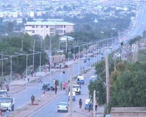
Kelafo (Somali : Qalaafe, Amharic : ቀላፎ, romanized: Qällafo) is a town in eastern Ethiopia. Located in the Gode Zone of the Somali Region, this town has a latitude and longitude of 05°35′20″N44°12′20″E / 5.58889°N 44.20556°E and an elevation of 233 meters above sea level.
The Kelafo Woreda is located 95 km south of Gode zone (headquarter) and 820 km from the Somali National Region capital- Jijiga. The total distance from capital of Ethiopia (Addis Ababa) is almost 1500 km. Kelafo (Somali: Qalaafe) is bordered on the south by the Somalia, on the west by Adadle, on the northwest by Gode, on the northeast by the Korahe Zone, and on the east by Mustahil. And its astronomical location is found between 5° 40′ N and 44° 10′ E. Administratively, the woreda comprises eleven kebeles.of which two kebeles are semi urban areas, the remains are purely rural [1] The UN-OCHA-Ethiopia website provides details of the health clinic in Kelafo, which was built in 1991 with funds and equipment provided by the Australian government. [2] Kelafo is served by an airport (ICAO code HAKL), and a bridge across the Shebelle River which was scoured in the May 1995 floods. [3]