Kennon Road

Last updated

N54 (Philippines).svg
Kennon Road
Benguet Road
Rosario–Baguio Road
Kennon Road, Baguio City.jpg
Kennon Road as viewed from the Kennon Road Viewdeck
Route information
Maintained by Department of Public Works and Highways
La Union 2nd District Engineering Office
Benguet 1st District Engineering Office
Baguio City District Engineering Office
Length33.534 km (20.837 mi)
Component
highways
N54 (Philippines).svg N54
Restrictions
  • Philippines road sign R3-8.svg Trucks
  • Philippines road sign R3-7.svg Buses
Major junctions
North endN208 (Philippines).svgN54 (Philippines).svg N208 (Aspiras–Palispis Highway) / N54 (Governor Pack Road) in Baguio
Major intersections
South end
Location
Country Philippines
Provinces Benguet, La Union
Major cities Baguio
Towns Rosario, Pugo, Tuba
Highway system
  • Roads in the Philippines

Kennon Road, also known as the Rosario–Baguio Road, is a two lane 33.53-kilometer (20.83 mi) roadway in Benguet province in the Philippines connecting the mountain city of Baguio in Benguet to the lowland town of Rosario in La Union province. The project began in 1903 and opened for travel on January 29, 1905. Originally called Benguet Road, [1] it was later renamed in honor of its builder, Col. Lyman Walter Vere Kennon of the U.S. Army Corps of Engineers. It is the second oldest road that leads to Baguio, after Quirino Highway, and the shortest route to Baguio for travelers from Manila and provinces in central and southern Luzon. [2]

Contents

The entire road forms part of National Route 54 (N54) of the Philippine highway network.

Route description

As one of the four major access roads from the lowlands that lead to the highland city of Baguio, [3] most of Kennon Road's stretch encompasses the municipality of Tuba in the province of Benguet. [4] Settlements along the highway, known as Camps 1 to 8, were originally established for the pioneer builders of the road, [1] but have since been occupied by local residents. The steepest portion of the road between Camp 6 and Camp 7 is commonly known as "Zigzag Road" because of the numerous switchbacks required. The Bued River, which flows along a rocky canyon from lofty heights, and following this course the road was cut above the river bed.

The highway is a toll road, [3] [5] with the lower tollgate located about 2.5 kilometers (1.6 mi) from the junction at Pugo near Camp 1. The upper tollgate is about 13 kilometers (8.1 mi) south of Baguio near the Lion's Head and Camp 6, in Tuba.

History

Benguet Road construction crew near Camp 5, Tuba, Benguet ca1903 setting explosives into a sheer cliff of the Bued River Canyon. Benguet Road construction near Camp 5.jpeg
Benguet Road construction crew near Camp 5, Tuba, Benguet ca1903 setting explosives into a sheer cliff of the Bued River Canyon.
Kennon Road near Camp 7, Baguio in 1914 Recollections of full years (1914) (14786316433).jpg
Kennon Road near Camp 7, Baguio in 1914
Kennon Road, circa 1940s Philippine Island - Benguet - NARA - 68155876.jpg
Kennon Road, circa 1940s

As the American colonial government wanted to make Baguio a summer retreat to solidify Manila’s position, they decided to build a sturdy and reliable road to go there. They first tapped Charles W. Mead, who was a civil engineer, but he was subsequently replaced by Colonel N.M. Holmes. Two years after in 1903, the project was turned over to the administration of Lyman Kennon. [6]

The construction of the road commenced in 1903 by cutting across the mountains of Benguet with the combined efforts of various Filipinos, Americans, Chinese Filipinos and Japanese nationals. It was considered one of the most difficult and expensive civil engineering projects of its day, with expenditures by the newly established Insular Government of the Philippine Islands in excess of US$2.7 million. [7] The Americans were inimical and irked, as evident in their stance that it was the "Christian Feast Holidays" celebrated by the Filipinos that caused the delays in the completion of the road.

More than 2,300 foreign and local workers worked on the road. Aside from Filipino engineers and construction workers and U.S. Army Corps of Engineers headed by Col. Lyman Kennon, foreigners from 36 countries were recruited to work on the road; the majority, at about 1,500 or 22%, were Japanese, and about 1,000 were Chinese. [8] [9] The road proved to be a more challenging and dangerous than the original plan of Mead. Hundreds of workers died from malaria and dysentery while more plunged to their deaths while building the road. They are also affected when intense rainpour dredged their positions. The eventual result was in reality, a deviation from the original plan. After the road was completed, some of the foreign road workers, such as those from British Hong Kong and Japan, decided to remain in Baguio to live permanently, such as some Cantonese Chinese Filipinos or in the case of some Japanese Filipinos, move to work in Abaca plantations in Mintal or Calinan in Davao City. [2]

The original road was a Macadam Telford-type road which was later improved into an all-weather asphalt roadway. More recently, some portions of Kennon Road have been replaced with concrete pavement. [10]

The highway was severely damaged by the 1990 Luzon earthquake [3] that the Department of Public Works and Highways decided for the permanent closure of the road. [11] The highway was proposed to be replaced by a road traversing through the town of Itogon on the way to the lowlands of San Manuel, but was met with criticism from the inhabitants of Baguio. Kennon Road was reopened for public use on September 1, 1991, after rehabilitation efforts were completed. [11] Throughout the years, however, the road has been subjected to temporary closures due to landslides that occurred during heavy storms or earthquakes. [12] The road is currently being repaired and maintained by the Department of Public Works and Highways (DPWH) with usage limited only to light vehicles and only to residents living around the area. [13] The rehabilitation and improvement of Kennon Road is currently being considered to be put under the Public-Private Partnership (PPP) scheme with the DPWH starting consultations with an international firm for a pre-feasibility study regarding the project. [14] [15]

In December 2021, Republic Act No. 11604 was signed into law which mandates the Department of Public Works and Highways to undertake the full rehabilitation and maintenance of Kennon Road. [16]

Road hazards

Rehabilitation works on the retaining wall of the Uabac section of the road was done in 2016 after it was damaged by continuous rains the year before. Kennon Road rehabilitation Uabac 2016.jpg
Rehabilitation works on the retaining wall of the Uabac section of the road was done in 2016 after it was damaged by continuous rains the year before.

Kennon Road is one of the most hazardous roads in the Philippines, [18] especially during rainy seasons, when road accidents are common. The road is closed during heavy rains or typhoon conditions to avoid casualties from landslides. [18] [19] [20] [21]

Portions of the highway are also prone to land-sinking, particularly along Barangay Camp 3 in Tuba. [22]

It usually takes an experienced commuter from 45 minutes to an hour to negotiate the 41.2-kilometer (25.6 mi) steep and winding climb by car. [10]

Intersections

Intersections are numbered by kilometer posts, with Rizal Park in Manila designated as kilometer zero. 

RegionProvinceCity/Municipality [lower-alpha 1] km [lower-alpha 1] miDestinationsNotes
Ilocos Region La Union Rosario 214.613133.354N2 (Philippines).svg N2 (Manila North Road)Southern terminus
Pugo No major junctions
Camp 1 toll gate
Ilocos RegionCAR boundary La UnionBenguet boundary PugoTuba boundary215.155–
215.158
133.691–
133.693
La Union 2nd District Engineering Office–Benguet 1st Engineering Office highway boundary
Cordillera Administrative Region Benguet Tuba Camp 1 Bridge 1 over Bued River
Colorado Bridge
227.038141.075Ampasit Bridge
227.784141.538Camp 3 Bridge 2
Ataki Bridge
Camp 4 Bridge 1 over Bued River
231.127143.616Camp 4 Bridge 2
Pugo Bridge over Bued River
232.259144.319Maramal Bridge over Bued River
Camp 4 Bridge 4
233.358145.002Camp 4 Bridge 5
Camp 5 Bridge 1
235.465146.311Camp 5 Bridge 2
237.940147.849Camp 6 Bridge
Demonstration Bridge over Basa Creek
Camp 6 toll gate
TubaBaguio boundary239.593–
240.899
148.876–
149.688
Benguet 1st District Engineering Office–Baguio City Engineering Office highway boundary. Lion's Head.
Baguio 245.158152.334N231 (Philippines).svg N231 (Loakan Road)
246.550153.199N233 (Philippines).svg N233 (Monticello Road)
Military Cut-off Road
248.147154.191N54 (Philippines).svgN208 (Philippines).svg N54 (Governor Pack Road) / N208 (Aspiras–Palispis Highway)Roundabout. Northern terminus.
1.000 mi = 1.609 km; 1.000 km = 0.621 mi

Notes

  1. 1 2 Sources: [23] [24] [25]

Related Research Articles

<span class="mw-page-title-main">Baguio</span> Highly urbanized city in Benguet, Philippines

Baguio, officially the City of Baguio, is a 1st class highly urbanized city in the Cordillera Administrative Region, Philippines. It is known as the "Summer Capital of the Philippines", owing to its cool climate since the city is located approximately 4,810 feet above mean sea level, often cited as 1,540 meters in the Luzon tropical pine forests ecoregion, which also makes it conducive for the growth of mossy plants, orchids and pine trees, to which it attributes its other moniker as the "City of Pines".

<span class="mw-page-title-main">Benguet</span> Province in Cordillera, Philippines

Benguet, officially the Province of Benguet, is a landlocked province of the Philippines located in the southern tip of the Cordillera Administrative Region in the island of Luzon. Its capital is La Trinidad.

<span class="mw-page-title-main">EDSA</span> Limited-access circumferential highway around Metro Manila

Epifanio de los Santos Avenue, commonly referred to by its acronym EDSA, is a limited-access circumferential highway around Manila, the capital city of the Philippines. It passes through 6 of Metro Manila's 17 local government units or cities, namely, from north to south, Caloocan, Quezon City, San Juan, Mandaluyong, Makati, and Pasay.

<span class="mw-page-title-main">Atok, Benguet</span> Municipality in Benguet, Philippines

Atok, officially the Municipality of Atok,, is a 4th class municipality in the province of Benguet, Philippines. According to the 2020 census, it has a population of 19,218 people.

<span class="mw-page-title-main">Tuba, Benguet</span> Municipality in Benguet, Philippines

Tuba, officially the Municipality of Tuba,, is a 1st class municipality in the province of Benguet, Philippines. According to the 2020 census, it has a population of 48,312 people.

<span class="mw-page-title-main">Session Road</span> Road in Baguio, Philippines

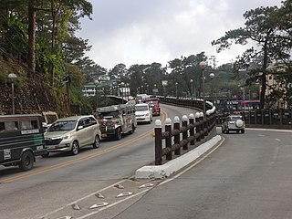
Session Road is a six-lane 1.7-kilometer (1.1 mi) major road in Baguio, Philippines. The entire road forms part of National Route 231 (N231) of the Philippine highway network.

<span class="mw-page-title-main">Mount Cabuyao</span> Mountain on the island of Luzon, Philippines

Mount Cabuyao is a mountain in the Philippines located in the municipality of Tuba in the province of Benguet. Its summit, rising to more than 2,000 metres (6,600 ft) above sea level, overlooks the city of Baguio. It is commonly mistaken as Mount Santo Tomas, a taller mountain just beside it.

<span class="mw-page-title-main">Tarlac–Pangasinan–La Union Expressway</span> Expressway in the Philippines

The Tarlac–Pangasinan–La Union Expressway (TPLEX), signed as E1 of the Philippine expressway network and R-8 of the Metro Manila arterial road network, is a controlled-access toll expressway that connects the Central Luzon region with the Ilocos Region. From its northern terminus at Rosario in La Union to its southern terminus at Tarlac City, the expressway has a length of 89.21-kilometer (55.43 mi), cutting through the various provinces in northern Central Luzon. Despite that the name only stating the provinces of Tarlac, Pangasinan, and La Union, the expressway also passes the province of Nueva Ecija between Tarlac and Pangasinan, but without any exits to serve the said province.

<span class="mw-page-title-main">Metro Baguio</span> Metropolitan area in Philippines

Metro Baguio, also known as BLISTT, is an agglomeration of the city of Baguio and five municipalities of the Philippine province of Benguet, namely: La Trinidad, Itogon, Sablan, Tuba, and Tublay.

<span class="mw-page-title-main">Lyman W. V. Kennon</span> United States Army general (1858–1918)

Lyman Walter Vere Kennon was a career United States military officer in active service from 1881 to 1918, attaining the rank of brigadier general. During the Spanish–American War Kennon was in command of Company "E" 6th Infantry Regiment and was cited for bravery at San Juan Hill. He was most recognized for his 1903–1905 work with the Corps of Engineers to lead the building of the Benguet Road, a mountain highway in the Philippines linking Rosario, La Union and the lowland areas to Baguio. During World War I, he commanded the military training facility at Camp Greene, North Carolina; the 171st Infantry, Brigade, Camp Grant, Illinois, and then the 86th Division, Camp Grant, Illinois.

<span class="mw-page-title-main">Halsema Highway</span>

The Halsema Highway is a national secondary highway in the Philippines. Situated within the Cordillera Central range in northern Luzon, it stretches from the city limit of Baguio to the municipality of Bontoc. Its highest point is at 7,400 feet (2,300 m) above sea level in the municipality of Atok. It was officially recognized as the highest altitude highway in the Philippines until 2019, when the 2.429-kilometer (7,970 ft) high point Kiangan–Tinoc–Buguias Road in Tinoc, Ifugao, was recognized as the new holder of the distinction.

<span class="mw-page-title-main">Lion's Head (Benguet)</span>

The Lion's Head is a statue along Kennon Road, a major highway in Luzon, Philippines. Located in Camp 6 near the Baguio–Tuba boundary, the Lion's Head measures 40 ft (12 m) in height.

<span class="mw-page-title-main">Aspiras–Palispis Highway</span> Road in Luzon, Philippines

The Aspiras–Palispis Highway is a Philippine major highway in northern Luzon that runs from the city of Baguio in the province of Benguet to the municipality of Agoo in the province of La Union.

<span class="mw-page-title-main">Naguilian Road</span> Road in Luzon, Philippines

The Naguilian Road, officially the Quirino Highway and also known as the Baguio–Bauang Road, is a Philippine major highway in northern Luzon that runs from the city of Baguio in the province of Benguet to the municipality of Bauang in the province of La Union.

<span class="mw-page-title-main">Bued River</span> River in Ilocos Region, Philippines

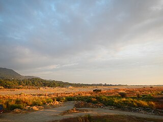
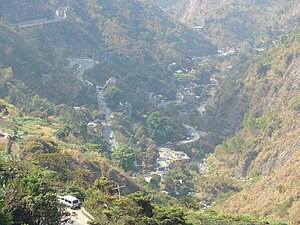
The Bued River is a river in the island of Luzon in the Philippines with a total length of 80 km (50 mi). It covers primarily the provinces of Benguet and Pangasinan, and a few parts of La Union. The river originates from the city of Baguio and joins with the Angalacan River in the municipality of Mangaldan, Pangasinan to form the Cayanga River.

<span class="mw-page-title-main">Governor Pack Road</span> Major street in Baguio, Philippines

The Governor Pack Road is a major highway in Baguio, Philippines, named for the American William Francis Pack (1861-1944), who was appointed Military Governor of Benguet on November 15, 1901 and served as the civilian Governor of Mountain Province, in which Benguet was once part of as a subprovince, from 1909 to 1912.

<span class="mw-page-title-main">Asin Road</span> Road in Luzon, Philippines

The Asin–Nangalisan–San Pascual Road is a major road in La Union and Benguet, Philippines, serving as an alternative route to Baguio. This road is dangerous, and has tunnels along the way which used to be intended for rail services from Aringay to Baguio. The road officially opened to public on December 17, 2018.

The Benguet–Nueva Vizcaya Road,, is the road system that connects the provinces of Benguet and Nueva Vizcaya in the Philippines.

The Philippine highway network is a network of national roads owned and maintained by the Department of Public Works and Highways (DPWH) and organized into three classifications according to their function or purpose: national primary, secondary, and tertiary roads. The national roads connecting major cities are numbered from N1 to N83. They are mostly single and dual carriageways linking two or more cities.

<span class="mw-page-title-main">Marquez Go</span> Filipino businessman and politician

Marquez "Mark" Ocampo Go is a Filipino businessman and politician. A member of the Nacionalista Party, he is the incumbent representative of the legislative district of Baguio since 2016. He is also an outstanding citizen of Baguio awardee in 1998.

References

  1. 1 2 Kennon, Lyman. "Kennon's own report on the famous zig–zag". Baguio Midland Courier. Retrieved September 30, 2014.
  2. 1 2 Bankoff, Greg. (2005). These brothers of ours: Poblete's obreros and the road to Baguio 1903–1905. Journal of Social History - Volume 38, Number 4, Summer 2005, pp. 1047-1072 PDF at University of Auckland
  3. 1 2 3 "Kennon Road". City of Pines. Archived from the original on October 26, 2014. Retrieved September 30, 2014.
  4. "Kennon Rd" (Map). Mapcentral. Retrieved September 30, 2014.
  5. Montecillo, Paolo (March 14, 2012). "Hike in toll on Kennon Road looms". Philippine Daily Inquirer . Retrieved September 30, 2014.
  6. Tinio McKenna, Rebecca (2019). American Imperial Pastoral: The Architecture of US Colonialism in the Philippines. Ateneo de Manila University Press.
  7. "Baguio City Centennial September 1, 1909". Balita Pinoy. Retrieved December 1, 2010.
  8. Afable, Patricia (2008). "Compelling Memories and Telling Archival Documents and Photographs: The Search for the Baguio Japanese Community" (PDF). Asian Studies. 44 (1).
  9. https://thephilippinestoday.com/kennon-road-history/
  10. 1 2 "CityofPines.com - Kennon Road". Archived from the original on October 26, 2014. Retrieved August 8, 2006.
  11. 1 2 Cabreza, Vincent (May 16, 2012). "Fighting for century-old Kennon Road". Philippine Daily Inquirer . Retrieved October 5, 2014.
  12. Ilao, Micaella (July 29, 2017). "Kennon Road closed due to landslides". ABS-CBN. Retrieved April 2, 2021.
  13. Alimondo, Lauren (September 25, 2020). "Constructions on Kennon Road to continue". Sunstar Baguio. Retrieved April 2, 2021.
  14. "Improvement, Operation, and Maintenance of Kennon Road Project". Republic of the Philippines - Public-Private Partnership Center. Retrieved April 2, 2021.
  15. Balinbin, Arjay (February 3, 2021). "European firm's consulting services for Kennon Road start". BusinessWorld. Retrieved April 2, 2021.
  16. Parrocha, Azer. "PRRD signs law mandating full rehab, maintenance of Kennon Road". PNA. Retrieved January 15, 2022.
  17. Cawis, Redjie Melvic (June 10, 2016). "DPWH advises motorists to avoid Kennon Road due to rehab works". Philippine Information Agency. Retrieved September 3, 2016.
  18. 1 2 "Kennon Road". Dangerous Roads. Retrieved September 30, 2014.
  19. "Rains trigger landslide along Kennon Road in Benguet". GMA News. April 30, 2010. Retrieved September 30, 2014.
  20. Locsin, Joel (September 15, 2014). "Kennon Road closed, 11 roads impassable due to landslides caused by Luis". GMA News. Retrieved September 30, 2014.
  21. "1 killed in Benguet landslide; Kennon Road closed". GMA News. August 12, 2013. Retrieved September 30, 2014.
  22. Arthur, Allad-iw (August 26, 2014). "Residents of sinking Kennon Road village urged to move to safer ground". Northern Dispatch (InterAksyon). Retrieved September 30, 2014.
  23. "La Union 2nd". 2016 DPWH Atlas. Department of Public Works and Highways . Retrieved May 22, 2016.
  24. "Benguet 1st". 2016 DPWH Atlas. Department of Public Works and Highways . Retrieved May 22, 2016.
  25. "Baguio City". 2016 DPWH Atlas. Department of Public Works and Highways . Retrieved May 22, 2016.