This page is based on this
Wikipedia article Text is available under the
CC BY-SA 4.0 license; additional terms may apply.
Images, videos and audio are available under their respective licenses.

Lanchkhuti is a city in western Georgian region of Guria. It has a population of about 8000.

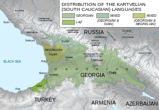
Guria is a region (mkhare) in Georgia, in the western part of the country, bordered by the eastern end of the Black Sea. The region has a population of 113,000 (2016), with Ozurgeti as the regional capital.

Tsanareti was a historic district (Khevi) in the early medieval Caucasus, lying chiefly in what is now the northeastern corner in Georgia’s region of Mtskheta-Mtianeti.

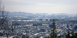
Chokhatauri is a town in Georgia’s Guria region, 310 km west to the nation’s capital of Tbilisi. It is an administrative center of Chokhatauri Municipality, which comprises the town itself and its adjoining 60 villages. The area of the district is 824 km2; population – 1815 (2014).

The Principality of Guria was a historical state in Georgia. Centered on modern-day Guria, a southwestern region in Georgia, it was located between the Black Sea and Lesser Caucasus, and was ruled by a succession of twenty-two princes of the House of Gurieli from the 1460s to 1829. The principality emerged during the process of fragmentation of a unified Kingdom of Georgia. Its boundaries fluctuated in the course of permanent conflicts with neighboring Georgian rulers and Ottoman Empire, and the principality enjoyed various degrees of autonomy until being annexed by Imperial Russia in 1829.
Naruja(Georgian: ნარუჯა) is a village in western Georgian region of Guria.
Lanchkhuti is a district of Georgia, in the region of Guria. Its main town is Lanchkhuti.

Chokhatauri is a district of Georgia, in the region of Guria. Its largest city and administrative centre is Chokhatauri.

Ureki is a town and a seaside climatic resort on the Black Sea coast of Georgia. Located within Ozurgeti District in the region of Guria, Ureki is 60 kilometers north of Batumi and approximately 300 km west of the nation's capital Tbilisi. It is located 4 meters above the sea level and has a population of 1,422. It received a status of a town in 1953.
The Ujmajuridze is a Georgian family name from the Guria region in western Georgia.

Kobi is a village in the historical region of Khevi, Georgia. Administratively, it is part of the Kazbegi Municipality in Mtskheta-Mtianeti. It is a community center of Truso Valley villages. Distance to the municipality center Stepantsminda is 20 km.

Kartsopheli is a village in the historical region of Khevi, north-eastern Georgia. It is located on the left bank of the river Tergi. Administratively, it is part of the Kazbegi Municipality in Mtskheta-Mtianeti. Distance to the municipality center Stepantsminda is 38 km.
Almasiani is a village in the historical region of Khevi, north-eastern Georgia. It is located on the banks of the river Tergi and its right bank tributary river Bidara. Administratively, it is part of the Kazbegi Municipality in Mtskheta-Mtianeti. Distance to the municipality center Stepantsminda is 18 km.

Shevardeni is a village in the historical region of Khevi, north-eastern Georgia. It is located on the left bank of the river Tergi. Administratively, it is part of the Kazbegi Municipality in Mtskheta-Mtianeti. Distance to the municipality center Stepantsminda is 23 km.
Gusalti is a village in the historical region of Khevi, north-eastern Georgia. It is located on the left bank of the river Tergi, on the southern slopes of the Khokhi Range. Administratively, it is part of the Kazbegi Municipality in Mtskheta-Mtianeti. Distance to the municipality center Stepantsminda is 43 km.
Ukhati is a village in the historical region of Khevi, north-eastern Georgia. It is located on the right bank of the Tergi river. Administratively, it is part of the Kazbegi Municipality in Mtskheta-Mtianeti. Distance to the municipality center Stepantsminda is 21 km.
Mna is a village in the historical region of Khevi, north-eastern Georgia. It is located on the left bank of the Tergi tributary river – Mnaisistskali. Administratively, it is part of the Kazbegi Municipality in Mtskheta-Mtianeti. Distance to the municipality center Stepantsminda is 29 km.
Tepi is a village in the historical region of Khevi, north-eastern Georgia. It is located on the left bank of the Tergi river. Administratively, it is part of the Kazbegi Municipality in Mtskheta-Mtianeti. Distance to the municipality center Stepantsminda is 44.5 km.
Resi is a village in the historical region of Khevi, north-eastern Georgia. It is located on the left bank of the Tergi river. Administratively, it is part of the Kazbegi Municipality in Mtskheta-Mtianeti. Distance to the municipality center Stepantsminda is 42 km.