Thai, Central Thai, is the sole official and national language of Thailand and the first language of the Central Thai people and vast majority of Thai Chinese. It is a member of the Tai group of the Kra–Dai language family. Over half of Thai vocabulary is derived from or borrowed from Pali, Sanskrit, Mon and Old Khmer. It is a tonal and analytic language, similar to Chinese and Vietnamese.
Phetchabun is one of the central or northern provinces (changwat) of Thailand. Neighboring provinces are Loei, Khon Kaen, Chaiyaphum, Lopburi, Nakhon Sawan, Phichit, and Phitsanulok.
Phichit is a province (changwat) of Thailand. It lies 330 km due north of Bangkok. Neighboring provinces are Phitsanulok, Phetchabun, Nakhon Sawan, and Kamphaeng Phet.
The watercourse is referred to by a lot of local names including Khlong Duea (คลองเดื่อ), Khlong Yai (คลองใหญ่), Khlong Wang Pong (คลองวังโป่ง), Khlong Phikun (คลองพิกุล), Khlong Lam Prada (คลองลำประดา), Khlong Daeng (คลองแดง), Khlong Thap Khlo (คลองทับคล้อ), Khlong Bang Phai (คลองบางไผ่), Khlong Thai Thung (คลองท้ายทุ่ง) and Khlong San Thao.
A geographic coordinate system is a coordinate system that enables every location on Earth to be specified by a set of numbers, letters or symbols. The coordinates are often chosen such that one of the numbers represents a vertical position and two or three of the numbers represent a horizontal position; alternatively, a geographic position may be expressed in a combined three-dimensional Cartesian vector. A common choice of coordinates is latitude, longitude and elevation. To specify a location on a plane requires a map projection.
This article related to a river in Thailand is a stub. You can help Wikipedia by expanding it.
This page is based on this Wikipedia article Text is available under the CC BY-SA 4.0 license; additional terms may apply. Images, videos and audio are available under their respective licenses.
Related Research Articles
The Chao Phraya is the major river in Thailand, with its low alluvial plain forming the centre of the country. It flows through Bangkok and then into the Gulf of Thailand.
The Pa Sak River is a river in central Thailand. The river originates in the Phetchabun Mountains, Dan Sai District, Loei Province, and passes through Phetchabun Province as the backbone of the province. It then passes through the eastern part of Lopburi Province and Saraburi Province, until it joins together with the Lopburi River northeast of Ayutthaya Island, before it runs into the Chao Phraya River southeast of Ayutthaya near Phet Fortress. It has a length of 513 km (319 mi) and drains a watershed of 16,291 km2 (6,290 sq mi). The annual discharge is 2.4 km3 (0.58 cu mi).
Wiang Sa is a district (amphoe) of Surat Thani Province, Thailand.
The Tha Chin river is a distributary of the Chao Phraya river, Thailand. It splits near the province of Chai Nat and then flows west from the Chao Phraya through the central plains, until it empties into the Gulf of Thailand in Samut Sakhon Province.
The Nan River is a river in Thailand. It is one of the most important tributaries of the Chao Phraya River.
Hua Ro is a subdistrict in the Mueang Phitsanulok District of Phitsanulok Province, Thailand.
Ban Khlong is a subdistrict in the Mueang Phitsanulok District of Phitsanulok Province, Thailand.
Huai Krasiao or Khlong Krasiao is a watercourse in the province of Uthai Thani and Suphan Buri, Thailand. It is a tributary of the Tha Chin River.
Khlong Bang Len is a watercourse in Nakhon Pathom Province, Thailand. It is a tributary of the Tha Chin River.
Khlong Muak Lek or Huai Muak Lek is a watercourse of Thailand. It is a tributary of the Pa Sak River, part of the Chao Phraya River basin.
Khlong Lam Kong is a watercourse in Phetchabun Province, Thailand. It is a tributary of the Pa Sak River, part of the Chao Phraya River basin.
Khlong Wang Chomphu is a watercourse in Phetchabun Province, Thailand. It is a tributary of the Pa Sak River, part of the Chao Phraya River basin.
Khlong Huai Na is a watercourse of Thailand. It is a tributary of the Pa Sak River, part of the Chao Phraya River basin.
Khlong Saduang Yai is a watercourse of Thailand. It is a tributary of the Pa Sak River, part of the Chao Phraya River basin.
Khlong Ban Bong is a watercourse of Thailand. It is a tributary of the Pa Sak River, part of the Chao Phraya River basin.
Khlong Pho is a watercourse in the provinces of Nakhon Sawan and Uthai Thani, Thailand. It is a tributary of the Sakae Krang River, part of the Chao Phraya River basin.
Khlong Tron is a watercourse of Thailand and part of the Chao Phraya River basin. It joins the Nan River in Uttaradit Province.
Lam Wa is a watercourse of the Thai highlands in Thailand, a tributary of the Nan River, part of the Chao Phraya River basin. It has its source beneath 1,745-metre (5,725 ft) high Doi Phi Pan Nam mountain of the Luang Prabang Range and joins the Nan River near Wiang Sa town in Wiang Sa District, Nan Province.
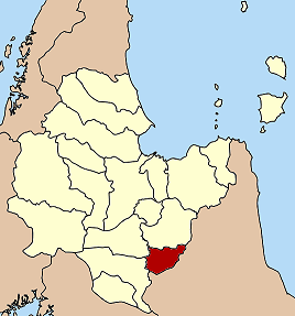
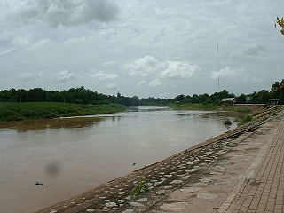
Khlong Butsabong is a watercourse in the provinces of Phetchabun and Phichit, Thailand, and part of the overall Chao Phraya River basin. It is a direct tributary of the Nan River in the lower Nan basin.