Khvalynsky District

Last updated
Khvalynsky District
Хвалынский район(Russian)
Khvalynsky district locator map.svg
Location of Khvalynsky District in Saratov Oblast
Coordinates: 52°29′N48°06′E / 52.483°N 48.100°E / 52.483; 48.100 Coordinates: 52°29′N48°06′E / 52.483°N 48.100°E / 52.483; 48.100
Khvalynskii natsional'nyi park.jpg
Hills in Khvalynsky National Park, Khvalynsky District
Coat of Arms of Khvalynsk (Saratov oblast).png
Coat of arms
Location
Country Russia
Federal subject Saratov Oblast [1]
Administrative structure (as of 2012)
Administrative center town of  Khvalynsk [2]
Inhabited localities: [2]
Rural localities 28
Municipal structure (as of March 2013)
Municipally incorporated asKhvalynsky Municipal District [3]
Municipal divisions: [4]
Urban settlements1
Rural settlements7
Statistics
Area 1,900 km2 (730 sq mi)[ citation needed ]
Population (2010 Census) 10,688 inhabitants [5]
 Urban0%
 Rural100%
Density 5.63/km2 (14.6/sq mi) [6]
Time zone SAMT (UTC+04:00) [7]
Official website
Khvalynsky District on WikiCommons

Khvalynsky District (Russian : Хвалынский райо́н) is an administrative [1] and municipal [3] district (raion), one of the thirty-eight in Saratov Oblast, Russia. It is located in the north of the oblast. The area of the district is 1,900 square kilometers (730 sq mi).[ citation needed ] Its administrative center is the town of Khvalynsk [2] (which is not administratively a part of the district). [8] Population: 10,688 (2010 Census); [5] 12,962(2002 Census); [9] 15,297(1989 Census). [10]

Russian language East Slavic language

Russian is an East Slavic language, which is official in the Russian Federation, Belarus, Kazakhstan and Kyrgyzstan, as well as being widely used throughout Eastern Europe, the Baltic states, the Caucasus and Central Asia. It was the de facto language of the Soviet Union until its dissolution on 25 December 1991. Although nearly three decades have passed since the breakup of the Soviet Union, Russian is used in official capacity or in public life in all the post-Soviet nation-states, as well as in Israel and Mongolia.

A raion is a type of administrative unit of several post-Soviet states. The term is from the French "rayon", which is both a type of a subnational entity and a division of a city, and is commonly translated in English as "district".

Contents

Administrative and municipal status

Within the framework of administrative divisions, Khvalynsky District is one of the thirty-eight in the oblast. [1] The town of Khvalynsk serves as its administrative center, [2] despite being incorporated separately as a town under oblast jurisdiction—an administrative unit with the status equal to that of the districts (and which, in addition to Khvalynsk, also includes six rural localities). [8]

Khvalynsk Town in Saratov Oblast, Russia

Khvalynsk is a river port town in Saratov Oblast, Russia, located by the Volga River. Population: 13,094 (2010 Census); 13,752 (2002 Census); 14,948 (1989 Census); 16,000 (1974).

City of federal subject significance is an umbrella term used to refer to a type of an administrative division of a federal subject of Russia which is equal in status to a district but is organized around a large city; occasionally with surrounding rural territories.

As a municipal division, the district is incorporated as Khvalynsky Municipal District, [3] with Khvalynsk Town Under Oblast Jurisdiction being incorporated within it as Khvalynsk Urban Settlement. [4]

Related Research Articles

Marks, Russia Town in Saratov Oblast, Russia

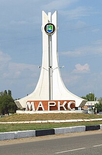
Marks, also spelled Marx, named after Karl Marx, is a town in Saratov Oblast, Russia, located 60 kilometers (37 mi) northeast of Saratov, the administrative center of the oblast. Population: 31,531 (2010 Census); 32,849 (2002 Census); 31,908 (1989 Census).

Rtishchevo Town in Saratov Oblast, Russia

Rtishchevo is a town in Saratov Oblast, Russia, located 214 kilometers (133 mi) west of Saratov, the administrative center of the oblast. Population: 41,289 (2010 Census).

Krasnoarmeysk, Saratov Oblast Town in Saratov Oblast, Russia

Krasnoarmeysk is a town in Saratov Oblast, Russia, located 75 kilometers (47 mi) south of Saratov, the administrative center of the oblast. Population: 24,364 (2010 Census); 25,411 (2002 Census); 24,055 (1989 Census).

Alexandrovo-Gaysky District District in Saratov Oblast, Russia

Alexandrovo-Gaysky District is an administrative and municipal district (raion), one of the thirty-eight in Saratov Oblast, Russia. It is located in the southeast of the oblast. The area of the district is 2,700 square kilometers (1,000 sq mi). Its administrative center is the rural locality of Alexandrov Gay. Population: 16,855 ; 17,763 (2002 Census); 17,003 (1989 Census). The population of Alexandrov Gay accounts for 57.7% of the district's total population.

Arkadaksky District District in Saratov Oblast, Russia

Arkadaksky District is an administrative and municipal district (raion), one of the thirty-eight in Saratov Oblast, Russia. It is located in the west of the oblast. The area of the district is 2,200 square kilometers (850 sq mi). Its administrative center is the town of Arkadak. Population: 26,236 ; 31,131 (2002 Census); 33,525 (1989 Census). The population of Arkadak accounts for 49.0% of the district's total population.

Bazarno-Karabulaksky District District in Saratov Oblast, Russia

Bazarno-Karabulaksky District is an administrative and municipal district (raion), one of the thirty-eight in Saratov Oblast, Russia. It is located in the north of the oblast. The area of the district is 2,300 square kilometers (890 sq mi). Its [[administrative center]] is the urban locality of Bazarny Karabulak. Population: 31,841 ; 36,571 (2002 Census); 36,391 (1989 Census). The population of Bazarny Karabulak accounts for 30.9% of the district's total population.

Ivanteyevsky District District in Saratov Oblast, Russia

Ivanteyevsky District is an administrative and municipal district (raion), one of the thirty-eight in Saratov Oblast, Russia. It is located in the northeast of the oblast. The area of the district is 2,000 square kilometers (770 sq mi). Its administrative center is the rural locality of Ivanteyevka. Population: 15,186 ; 16,151 (2002 Census); 15,972 (1989 Census). The population of Ivanteyevka accounts for 40.2% of the district's total population.

Kalininsky District, Saratov Oblast District in Saratov Oblast, Russia

Kalininsky District is an administrative and municipal district (raion), one of the thirty-eight in Saratov Oblast, Russia. It is located in the west of the oblast. The area of the district is 2,000 square kilometers (770 sq mi). Its administrative center is the town of Kalininsk. Population: 33,302 ; 39,732 (2002 Census); 39,739 (1989 Census). The population of Kalininsk accounts for 49.4% of the district's total population.

Krasnokutsky District District in Saratov Oblast, Russia

Krasnokutsky District is an administrative and municipal district (raion), one of the thirty-eight in Saratov Oblast, Russia. It is located in the south of the oblast. The area of the district is 2,900 square kilometers (1,100 sq mi). Its administrative center is the town of Krasny Kut. Population: 34,676 ; 36,445 (2002 Census); 37,551 (1989 Census). The population of Krasny Kut accounts for 41.6% of the district's total population.

Krasnopartizansky District District in Saratov Oblast, Russia

Krasnopartizansky District is an administrative and municipal district (raion), one of the thirty-eight in Saratov Oblast, Russia. It is located in the east of the oblast. The area of the district is 2,400 square kilometers (930 sq mi). Its administrative center is the urban locality of Gorny. Population: 13,008 ; 17,709 (2002 Census); 20,174 (1989 Census). The population of Gorny accounts for 39.1% of the district's total population.

Lysogorsky District District in Saratov Oblast, Russia

Lysogorsky District is an administrative and municipal district (raion), one of the thirty-eight in Saratov Oblast, Russia. It is located in the southwest of the oblast. The area of the district is 2,300 square kilometers (890 sq mi). Its administrative center is the urban locality of Lysye Gory. Population: 19,948 ; 21,260 (2002 Census); 20,797 (1989 Census). The population of Lysye Gory accounts for 36.0% of the district's total population.

Novoburassky District District in Saratov Oblast, Russia

Novoburassky District is an administrative and municipal district (raion), one of the thirty-eight in Saratov Oblast, Russia. It is located in the north of the oblast. The area of the district is 1,700 square kilometers (660 sq mi). Its administrative center is the urban locality of Novye Burasy. Population: 16,359 ; 18,188 (2002 Census); 16,703 (1989 Census). The population of Novye Burasy accounts for 35.9% of the district's total population.

Pitersky District District in Saratov Oblast, Russia

Pitersky District is an administrative and municipal district (raion), one of the thirty-eight in Saratov Oblast, Russia. It is located in the south of the oblast. The area of the district is 2,600 square kilometers (1,000 sq mi). Its administrative center is the rural locality of Piterka. Population: 18,054 ; 19,581 (2002 Census); 18,801 (1989 Census). The population of the administrative center accounts for 30.1% of the district's total population.

Pugachyovsky District District in Saratov Oblast, Russia

Pugachyovsky District is an administrative and municipal district (raion), one of the thirty-eight in Saratov Oblast, Russia. It is located in the northeast of the oblast. The area of the district is 3,900.6 square kilometers (1,506.0 sq mi). Its administrative center is the town of Pugachyov. As of the 2010 Census, the total population of the district was 20,031.

Romanovsky District, Saratov Oblast District in Saratov Oblast, Russia

Romanovsky District is an administrative and municipal district (raion), one of the thirty-eight in Saratov Oblast, Russia. It is located in the west of the oblast. The area of the district is 1,300 square kilometers (500 sq mi). Its administrative center is the urban locality of Romanovka. Population: 16,226 ; 18,150 (2002 Census); 19,404 (1989 Census). The population of Romanovka accounts for 44.8% of the district's total population.

Sovetsky District, Saratov Oblast District in Saratov Oblast, Russia

Sovetsky District is an administrative and municipal district (raion), one of the thirty-eight in Saratov Oblast, Russia. It is located in the center of the oblast. The area of the district is 1,400 square kilometers (540 sq mi). Its administrative center is the urban locality of Stepnoye. Population: 28,012 ; 30,195 (2002 Census); 28,936 (1989 Census). The population of Stepnoye accounts for 46.9% of the district's total population.

Turkovsky District District in Saratov Oblast, Russia

Turkovsky District is an administrative and municipal district (raion), one of the thirty-eight in Saratov Oblast, Russia. It is located in the northwest of the oblast. The area of the district is 1,400 square kilometers (540 sq mi). Its administrative center is the urban locality of Turki. Population: 12,834 ; 15,852 (2002 Census); 18,409 (1989 Census). The population of Turki accounts for 47.7% of the district's total population.

Volsky District District in Saratov Oblast, Russia

Volsky District is an administrative and municipal district (raion), one of the thirty-eight in Saratov Oblast, Russia. It is located in the north of the oblast. The area of the district is 3,700 square kilometers (1,400 sq mi). Its administrative center is the town of Volsk. Population: 27,457 ; 29,977 (2002 Census); 34,174 (1989 Census).

Yershovsky District District in Saratov Oblast, Russia

Yershovsky District is an administrative and municipal district (raion), one of the thirty-eight in Saratov Oblast, Russia. It is located in the eastern central part of the oblast. The area of the district is 4,300 square kilometers (1,700 sq mi). Its administrative center is the town of Yershov. Population: 41,609 ; 50,337 (2002 Census); 53,333 (1989 Census). The population of Yershov accounts for 51.5% of the district's total population.

References

Notes

  1. 1 2 3 Charter of Saratov Oblast
  2. 1 2 3 4 Государственный комитет Российской Федерации по статистике. Комитет Российской Федерации по стандартизации, метрологии и сертификации. №ОК 019-95 1 января 1997 г. «Общероссийский классификатор объектов административно-территориального деления. Код 63 249», в ред. изменения №278/2015 от 1 января 2016 г.. (State Statistics Committee of the Russian Federation. Committee of the Russian Federation on Standardization, Metrology, and Certification. #OK 019-95 January 1, 1997 Russian Classification of Objects of Administrative Division . Code 63 249, as amended by the Amendment #278/2015 of January 1, 2016. ).
  3. 1 2 3 Law #78-ZSO
  4. 1 2 Law #112-ZSO
  5. 1 2 Russian Federal State Statistics Service (2011). "Всероссийская перепись населения 2010 года. Том 1" [2010 All-Russian Population Census, vol. 1]. Всероссийская перепись населения 2010 года (2010 All-Russia Population Census) (in Russian). Federal State Statistics Service . Retrieved June 29, 2012.
  6. The value of density was calculated automatically by dividing the 2010 Census population by the area specified in the infobox. Please note that this value is only approximate as the area specified in the infobox does not necessarily correspond to the area of the entity proper or is reported for the same year as the population.
  7. Правительство Российской Федерации. Федеральный закон №107-ФЗ от 3 июня 2011 г. «Об исчислении времени», в ред. Федерального закона №271-ФЗ от 03 июля 2016 г. «О внесении изменений в Федеральный закон "Об исчислении времени"». Вступил в силу по истечении шестидесяти дней после дня официального опубликования (6 августа 2011 г.). Опубликован: "Российская газета", №120, 6 июня 2011 г. (Government of the Russian Federation. Federal Law #107-FZ of June 31, 2011 On Calculating Time , as amended by the Federal Law #271-FZ of July 03, 2016 On Amending Federal Law "On Calculating Time". Effective as of after sixty days following the day of the official publication.).
  8. 1 2 Государственный комитет Российской Федерации по статистике. Комитет Российской Федерации по стандартизации, метрологии и сертификации. №ОК 019-95 1 января 1997 г. «Общероссийский классификатор объектов административно-территориального деления. Код 63 445», в ред. изменения №278/2015 от 1 января 2016 г.. (State Statistics Committee of the Russian Federation. Committee of the Russian Federation on Standardization, Metrology, and Certification. #OK 019-95 January 1, 1997 Russian Classification of Objects of Administrative Division . Code 63 445, as amended by the Amendment #278/2015 of January 1, 2016. ).
  9. Russian Federal State Statistics Service (May 21, 2004). "Численность населения России, субъектов Российской Федерации в составе федеральных округов, районов, городских поселений, сельских населённых пунктов – районных центров и сельских населённых пунктов с населением 3 тысячи и более человек" [Population of Russia, Its Federal Districts, Federal Subjects, Districts, Urban Localities, Rural Localities—Administrative Centers, and Rural Localities with Population of Over 3,000](XLS). Всероссийская перепись населения 2002 года [All-Russia Population Census of 2002] (in Russian). Retrieved August 9, 2014.
  10. Demoscope Weekly (1989). "Всесоюзная перепись населения 1989 г. Численность наличного населения союзных и автономных республик, автономных областей и округов, краёв, областей, районов, городских поселений и сёл-райцентров" [All Union Population Census of 1989: Present Population of Union and Autonomous Republics, Autonomous Oblasts and Okrugs, Krais, Oblasts, Districts, Urban Settlements, and Villages Serving as District Administrative Centers]. Всесоюзная перепись населения 1989 года [All-Union Population Census of 1989] (in Russian). Институт демографии Национального исследовательского университета: Высшая школа экономики [Institute of Demography at the National Research University: Higher School of Economics]. Retrieved August 9, 2014.

Sources