Killamarsh

Last updated

Killamarsh
St Giles Church, Killamarsh - geograph.org.uk - 54362.jpg
St Giles Church, Killamarsh
Derbyshire UK location map.svg
Red pog.svg
Killamarsh
Location within Derbyshire
Population9,445 (civil parish, 2011) [1]
OS grid reference SK458806
Civil parish
  • Killamarsh
District
Shire county
Region
Country England
Sovereign state United Kingdom
Post town SHEFFIELD
Postcode district S21
Dialling code 0114
Police Derbyshire
Fire Derbyshire
Ambulance East Midlands
UK Parliament
List of places
UK
England
Derbyshire
53°19′14″N1°18′42″W / 53.3205°N 1.3116°W / 53.3205; -1.3116

Killamarsh is a village [2] and civil parish in North East Derbyshire, England, bordering Rotherham to the north and Sheffield to the north-west.

Contents

Killamarsh is surrounded by, in a clockwise direction from the north, Rother Valley Country Park, the village of Wales, South Yorkshire, Kiveton, Woodall, Harthill, Barlborough, Spinkhill, Renishaw, Eckington, and the (former Derbyshire) Sheffield suburbs of Oxclose, Halfway and Holbrook.

The name 'Killamarsh' is first attested in the Domesday Book of 1086, where it appears as Chinewoldemaresc. [3] It appears as Kinewaldesmers in the Charter Roll for 1249. The name means 'Cynewald's marsh'. [4]

History

Domesday records Killamarsh as belonging to Hascoit Musard and being valued at 12 pence. [3] The Grade II* listed parish church of St Giles was built between the 12th and 15th centuries using sandstone. Additions were made in 1895 by J. M. Brooks in magnesian limestone. The chancel south window is restored 15th-century stained glass, and the chancel east window of 1845 is by William Warrington. [5] A Grade II listed medieval cross stands in the graveyard. [6] A number of public houses in Killamarsh are over 300 years old.

Economy

The community originally grew from a farming community, self-sufficient in agricultural and dairy produce since the Middle Ages. In the 19th and 20th centuries, Killamarsh became a coal mining village as the burgeoning Sheffield iron industry demanded coal and transport links with Sheffield matured. Coal has been mined in Killamarsh since at least the 15th century, but the first major mining operation opened at Norwood resulting in an almost doubling of the Killamarsh population between 1861 and 1871. The last two "pits", Westthorpe and High Moor, are now gone, casualties of the early 1980s pit closure programme.

The river Rother which flanks Killamarsh had provided power to grain mills since the earliest times and was used by ironmongers and smiths from the late 18th century. [7] Killamarsh Forge was owned and operated by Webster & Horsfall. They made crucible steel which was cast into ingots. These were then shipped to their Penns Mill plant in Walmley, who drew the special wire. This was used in the core of the second trans-Atlantic telegraph cable laid by the SS Great Eastern in 1866 as well as other equipment used in the splicing operations.

There is an industrial estate located in the Norwood area north of the town and light industrial units and a business innovation centre to the south on the site of the old Westthorpe Colliery. To the west of Killamarsh is a small animal feed mill, and the factory of Ross and Catherall, a specialist alloys supplier to the aerospace industry.

Composition and geography

Killamarsh is situated on the eastern side of the Rother Valley. The centre of Killamarsh can be defined as the junction where Bridge Street meets Sheffield Road, from which point the roads lead to all other areas of the village.

Transport

Killamarsh is close to Sheffield, Chesterfield and Rotherham. The village is close to junctions 30 (Barlborough) and 31 (Aston) of the M1.

Killamarsh was once served by three railway stations:

The western side of Killamarsh was originally going to be significantly affected by the new HS2 route from Birmingham to Leeds, but following the government's favouring of an alternative route which will run parallel to the M1 motorway, this is no longer likely to be the case. [8]

Cycling

Killamarsh has a range of beneficiaries of the Sustrans Connect2 project for creating cycle routes. [9] The project has now drawn to a close with the final erection of two new pedestrian and cycle bridges crossing the River Rother and the railway on the border of North East Derbyshire and Sheffield.

Chesterfield Canal

The Chesterfield Canal passed through the village on its way to Kiveton via the Norwood Tunnel, which was the joint longest canal tunnel in the UK at the time of its construction. [10] The canal fell into disrepair following the collapse of the tunnel in 1907. The remains of the Chesterfield Canal are present but housing has been built on part of the canal's original route, and the undeveloped sections are mostly public footpaths.

The planned Rother Link will connect the Chesterfield Canal at Killamarsh, via the River Rother through to the Sheffield and South Yorkshire Navigation, thus creating a new cruising ring and encouraging boats to visit the Chesterfield Canal.

Rother Valley Park

Rother Valley Country Park lies to the north of the town. It was created in the early 1980s as part of the restoration works following open cast mining of the area. Originally managed by a joint board of Sheffield MBC, Rotherham MBC, South Yorkshire MCC and Derbyshire CC, the park is now wholly managed by Rotherham. The scheme created a series of ponds and lakes, with the surrounding area landscaped to form a nature reserve [11] and recreation areas, with facilities for water sports. The River Rother flows from the west of town and passes through the centre of the park. Gulliver's Valley, located beside the Rother Valley Park, is a theme park opened in 2020 on the site of a former colliery. [12] [13]

Notable residents

Sports teams

Killamarsh has many sports teams, in senior and junior age groups. The Killamarsh Dynamoes Athletic Football Club (KDAFC) is one of the many junior footballing sides in the area. Killamarsh Khaos Skater Hockey Club (KSHC) is a roller hockey club with age groups spanning from U10 (U12, U14, etc.) up to senior level. Killamarsh Juniors Athletic Club Institute hosts senior and junior football on its grounds as well as the Killamarsh Juniors Cricket Club (KJCC), which has age groups from U11 to three senior sides and a Sunday side.

See also

Related Research Articles

<span class="mw-page-title-main">Staveley, Derbyshire</span> Human settlement in England

Staveley is a town and civil parish in the Borough of Chesterfield, Derbyshire, England. Located along the banks of the River Rother. It is northeast of Chesterfield, west of Clowne, northwest of Bolsover, southwest of Worksop and southeast of Sheffield.

<span class="mw-page-title-main">Chesterfield, Derbyshire</span> Town in Derbyshire, England

Chesterfield is a market town in the Borough of Chesterfield, Derbyshire, England. It is 24 miles (39 km) north of Derby and 11 miles (18 km) south of Sheffield at the confluence of the River Rother and River Hipper. In 2011, the built-up-area subdivision had a population of 88,483, making it the second-largest settlement in Derbyshire, after Derby. The wider borough had a population of 103,801 in 2011. In 2011, the town had a population of 76,753.

<span class="mw-page-title-main">Chesterfield Canal</span> Canal in the East Midlands of England

The Chesterfield Canal is a narrow canal in the East Midlands of England and it is known locally as 'Cuckoo Dyke'. It was one of the last of the canals designed by James Brindley, who died while it was being constructed. It was opened in 1777 and ran for 46 miles (74 km) from the River Trent at West Stockwith, Nottinghamshire to Chesterfield, Derbyshire, passing through the Norwood Tunnel at Kiveton Park, at the time one of the longest tunnels on the British canal system. The canal was built to export coal, limestone, and lead from Derbyshire, iron from Chesterfield, and corn, deals, timber, groceries and general merchandise into Derbyshire. The stone for the Palace of Westminster was quarried in North Anston, Rotherham, and transported via the canal.

Anston is a civil parish in South Yorkshire, England, formally known as North and South Anston. The parish of Anston consists of the settlements of North Anston and South Anston, divided by the Anston Brook.

<span class="mw-page-title-main">River Rother, South Yorkshire</span> River in South Yorkshire, England

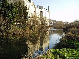
The River Rother, a waterway in the northern midlands of England, gives its name to the town of Rotherham and to the Rother Valley parliamentary constituency. It rises in Pilsley in Derbyshire and flows in a generally northwards direction through the centre of Chesterfield, where it feeds the Chesterfield Canal, and on through the Rother Valley Country Park and several districts of Sheffield before joining the River Don at Rotherham in Yorkshire. Historically, it powered mills, mainly corn or flour mills, but most had ceased to operate by the early 20th century, and few of the mill buildings survive.

<span class="mw-page-title-main">Maltby, South Yorkshire</span> Town and civil parish in South Yorkshire, England

Maltby is a former mining town and civil parish in the Metropolitan Borough of Rotherham, South Yorkshire, England. It was historically in the West Riding of Yorkshire. It is located about 6 miles (10 km) east of Rotherham town centre and 10 miles (16 km) north-east of Sheffield city centre. It forms a continuous urban area with Hellaby, separated from the rest of Rotherham by the M18 motorway. It had a population of 16,688 at the 2011 Census.

<span class="mw-page-title-main">Wales, South Yorkshire</span> Village and a civil parish in South Yorkshire, England

Wales is a village and a civil parish in the Metropolitan Borough of Rotherham in South Yorkshire, England. Historically part of the West Riding of Yorkshire, it borders to the south Derbyshire and is astride the M1 motorway. The civil parish of Wales, which has a population of 6,455, increasing to 7,069 at the 2011 Census, encompasses the village and neighbouring settlement Kiveton Park.

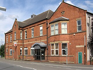
Kiveton Park is a village within the Metropolitan Borough of Rotherham, in South Yorkshire, England. Historically a part of the West Riding of Yorkshire, from the Norman conquest to 1868, Kiveton was a hamlet of the parish of Harthill-with-Woodall. It subsequently transferred to the civil parish of Wales which takes its name from the neighbouring village.

<span class="mw-page-title-main">Eckington, Derbyshire</span> Village in North East Derbyshire, England

Eckington is a village and civil parish in North East Derbyshire, England. It is 7 miles (11 km) northeast of Chesterfield and 9 miles (14 km) southeast of Sheffield city centre, on the border with South Yorkshire. It lies on the B6052 and B6056 roads close to the A6135 for Sheffield and Junction 30 of the M1. It had a 2001 population of 11,152, increasing to 11,855 at the 2011 Census.

<span class="mw-page-title-main">Kiveton Park F.C.</span> Association football club in England

Kiveton Park Football Club is a football club based in Kiveton Park, South Yorkshire, England. They are currently members of the Sheffield & Hallamshire County Senior League Division One and play at Wales High School.

<span class="mw-page-title-main">Catcliffe railway station</span> Disused railway station in South Yorkshire, England

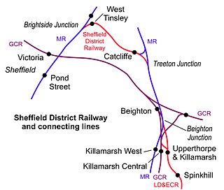
Catcliffe railway station is a former railway station in the Catcliffe area of Rotherham, South Yorkshire, England.

<span class="mw-page-title-main">Norwood Tunnel</span>

Norwood Tunnel was a 2,884-yard-long, 9-foot-3-inch-wide (2.82 m) and 12-foot-high (3.7 m) brick lined canal tunnel on the line of the Chesterfield Canal with its Western Portal in Norwood, Derbyshire and its Eastern Portal in Kiveton, South Yorkshire, England.

<span class="mw-page-title-main">Woodall, South Yorkshire</span> Hamlet in South Yorkshire, England

Woodall is a small hamlet in the civil parish of Harthill with Woodall situated in the Metropolitan Borough of Rotherham, South Yorkshire England. In the 2001 government census the parish as a whole had 1,909 inhabitants. It is home to a Welcome Break service station of the same name.

<span class="mw-page-title-main">Rother Link</span>

The Rother Link is a planned English canal that would connect the Chesterfield Canal at Killamarsh, via the River Rother through to the Sheffield and South Yorkshire Navigation, thus creating a new cruising ring and encouraging boats to visit the Chesterfield Canal.

<span class="mw-page-title-main">Brookhouse Colliery</span> Former coal mine in South Yorkshire

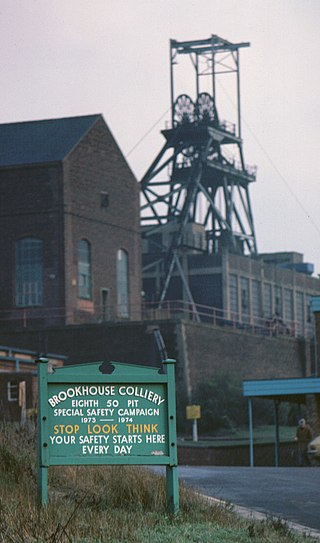
Brookhouse Colliery was a coal mine within the Metropolitan Borough of Rotherham, South Yorkshire, England. It was operational between 1929 and 1985.

The Lancashire, Derbyshire and East Coast Railway (LD&ECR) was built to connect coalfields in Derbyshire and Nottinghamshire with Warrington and a new port on the Lincolnshire coast. It was a huge undertaking, and the company was unable to raise the money to build its line. With the financial help of the Great Eastern Railway it managed to open between Chesterfield and Lincoln with a branch towards Sheffield from 1896. Despite efforts to promote tourist travel, the passenger business was never buoyant, but collieries were connected to the line, at first and in succeeding years. The Great Eastern Railway, and other main line companies, transported coal to the southern counties, and the company's engines took coal to Immingham in great quantities. The company had a fleet of tank engines.

<span class="mw-page-title-main">Clowne South railway station</span> Former railway station in Derbyshire, England

Clowne South railway station is a former railway station in Clowne, Derbyshire, England.

<span class="mw-page-title-main">Chesterfield Canal Trust</span>

The Chesterfield Canal Trust Limited is a waterway society and charitable company which campaigns for and undertakes various activities related to the Chesterfield Canal, which runs from Chesterfield in Derbyshire, England to the River Trent at West Stockwith.

<span class="mw-page-title-main">Beighton, South Yorkshire</span> Village in South Yorkshire, England

Beighton is a village 6 miles south-east of Sheffield's city centre, now classed as a historic township of the city. Due to much expansion, the village became a part of Sheffield city in 1967, and was transferred from Derbyshire to the newly created South Yorkshire, England. During much of the late 17th to 19th centuries the village was noted for its edge tool manufacturing, with Thomas Staniforth & Co Sickle works being based at nearby Hackenthorpe.

Beighton Junction is a set of railway junctions near Beighton on the border between Derbyshire and South Yorkshire, England.

References

  1. "Neighbourhood Statistics". Office for National Statistics . Retrieved 3 January 2015.
  2. "Killamarsh Parish Council". www.killamarsh-pc.gov.uk. Retrieved 2 January 2023.
  3. 1 2 Domesday Book: A Complete Translation. London: Penguin, 2003. ISBN   0-14-143994-7 p.753 and 1365
  4. Eilert Ekwall, The Concise Oxford Dictionary of English Place-names, p.275.
  5. Historic England. "Church of St Giles (1057656)". National Heritage List for England . Retrieved 13 July 2021.
  6. Historic England. "Medieval Cross 10 metres south of St Giles Church (1109641)". National Heritage List for England . Retrieved 13 July 2021.
  7. The Iron Men of Penns by John Horsfall
  8. "New Proposals to Re-Route HS2 in Killamarsh Area". North Derbyshire. Retrieved 23 July 2021.
  9. Killamarsh area
  10. Richardson, Christine (2009). Norwood Tunnel: Four Centuries of Challenge. Richlow Histories. ISBN   978-0-9552609-6-4.
  11. "Rother Valley Bird photos". Archived from the original on 19 February 2010. Retrieved 2 February 2010.
  12. "£37m theme park plan for Rotherham Pithouse West colliery site". BBC News. 10 September 2015. Retrieved 18 October 2021.
  13. "Rotherham Gulliver's Valley Theme park opens". BBC News. 11 July 2020. Retrieved 18 October 2021.
  14. Derbyshire at VictoriaCross.org Archived 17 July 2007 at the Wayback Machine Retrieved 18 June 2007
  15. Andy Hunter on the Cue Collector website http://www.thecuecollector.com/files/CueCollectorArticles/Hunter_Article_16__Sidney_Smith_.pdf Retrieved 7 December 2011
  16. "Show us the money pleads Owls fan Hobson". The Yorkshire Post. 6 August 2010. Retrieved 22 September 2021.