Killarney Provincial Park

Last updated
Killarney Provincial Park
George Lake.jpg
Early November at George Lake, Killarney Provincial Park
Canada Ontario location map 2.svg
Red pog.svg
Nearest city Sudbury, Ontario
Coordinates 46°06′N81°24′W / 46.100°N 81.400°W / 46.100; -81.400
Area485 km2 (187 sq mi)
Established1964
Governing body Ontario Parks

Killarney Provincial Park is a provincial park in central Ontario, Canada.

Contents

The park contains just one campground at the George Lake entrance as it is primarily a wilderness park. There are few facilities in order to allow visitors a chance to experience the solitude and beauty of its undisturbed natural setting. It has a number of hiking trails and canoe-in back-country camping. The canoe routes include well maintained portages between lakes. The campground includes six heated yurts which have electric lighting, a power outlet, a propane barbecue and bunk beds. [1]

Situated on the north shore of Georgian Bay in the municipality of Killarney, the park straddles the La Cloche range, large rounded white quartzite hills that dominate the landscape. The white peaks and cliffs contrast with the pine and hardwood forests and the boggy lowlands that surround the park's many lakes.

Quartzite is weather-resistant and contains few nutrient-bearing minerals. Soils, where present, tend to be shallow and infertile. Very stony sandy loam is the most common soil texture reported. Podzol profile development is usual in well-drained situations. Mineral-rich rock types such as diabase and limestone occur locally and the soils that have developed over them support some of the park's more luxuriant vegetation.

The park lies within the Eastern forest-boreal transition ecoregion, so there is a wide variety of plant life. [2] The park is home to moose, deer, black bears, wolves, lynx, bobcats, martens, and beavers along with over 20 species of reptiles and amphibians. Over 100 species of birds breed, nest or rest within park boundaries.

Origin

The origin of the park is owed to the conservation efforts of artists. Canadian Group of Seven artist A. Y. Jackson was so alarmed by the prospect that Trout Lake (now O.S.A. Lake) was about to be logged that he petitioned the Provincial government of the day to have it preserved. His letter was received by William Finlayson, then the Minister of Lands and Forests, resulting in a successful conclusion. The lake was taken into trust by the Ontario Society of Artists and its name was changed to O.S.A. Lake. Jackson's efforts were rewarded with the naming of a lake after him on his 90th birthday. The hills and lakes in the Killarney area became a popular place for painting and sketching and over the years several other members of the Group of Seven worked there including Franklin Carmichael, Arthur Lismer and A. J. Casson. In 1959 the Killarney Park area was set aside as a wilderness preserve. In 1962 Highway 637 opened, connecting the north shore of Georgian Bay all the way from the town of Killarney to the Trans-Canada Highway. Finally in 1964, with the help of lobbying efforts by the Group of Seven, 4,000 square miles (10,000 km2) of Georgian Bay shoreline were set aside as a wilderness reserve, and Killarney became a provincial park.

Panoramic view from the Granite Ridge Trail Killarney Provincial Park - October 2010.jpg
Panoramic view from the Granite Ridge Trail

The park has experienced some challenges that threaten the health of its delicate local ecosystems. Owing in large part to its proximity to Sudbury with its nickel mines and smelters, local lakes were damaged by acid rain. Pollution caused by the smelting activities associated with nickel mining between the 1940s and the 1970s, caused many of Killarney's lakes to become acidified, resulting in the loss of fish species, algae and aquatic plant life in many of the lakes. This damage was especially severe in the quartzite areas. Legislation passed in the 1970s forced the industry to improve its emissions standards. Since then, sulphur emissions have been reduced by over 90 percent. To date, water quality has improved in some lakes to pre-pollution levels, while in other lakes the slow process of biological recovery continues. More recently, the lakes have been under threat from non-indigenous invasive species such as the Bythotrephes longimanus (a.k.a. spiny water flea), which threaten local species.

In 2006, the provincial government also created the adjacent but separate provincial park of Killarney Lakelands and Headwaters. In 2015, the Wiikwemkoong First Nation on Manitoulin Island also established the adjacent Point Grondine Park on their own unoccupied heritage territory in the area.

Observatory

Killarney Provincial Park Observatory Killarney Provincial Park Observatory Day.jpg
Killarney Provincial Park Observatory

On July 17, 2010 the park officially opened the Killarney Provincial Park Observatory - the first public observatory in any Ontario Provincial Park. This observatory is available for both NHE directed programs as well as individual use (please contact the Park directly for information on availability of this facility). As the skies in Killarney Provincial Park are still pristine, this facility is ideal for all those interested in studying the night sky.

Dark-Sky Preserve

In 2018, Killarney Provincial Park was awarded the Royal Astronomical Society of Canada's Dark-Sky Preserve designation, the first Ontario Park to do so.

2018 Upgrade

KPPO Dome 2 with Dome Off-2 KPPO Dome 2 with Dome Off-2.jpg
KPPO Dome 2 with Dome Off-2

In celebration of 125 years of Ontario Parks and 150 years of the Royal Astronomical Society of Canada, the Killarney Provincial Park Observatory complex was upgraded to include a new observatory facility. This one includes a 16" fully automated Meade LX600 (primary instrument) and a Meade 130mm (5") apochromatic refractor (secondary instrument).

See also

Related Research Articles

<span class="mw-page-title-main">Thousand Islands – Frontenac Arch</span> Geologic region in North America

The Thousand Islands – Frontenac Arch region or the Frontenac Axis is an exposed strip of Precambrian rock in Canada and the United States that links the Canadian Shield from Algonquin Park with the Adirondack Mountain region in New York, an extension of the Laurentian mountains of Québec. The Algonquin to Adirondacks region, which includes the Frontenac Axis or Arch, is a critical linkage for biodiversity and resilience, and one with important conservation potential. The axis separates the St. Lawrence Lowlands and the Great Lakes Lowlands. It has many distinctive plant and animal species. It is one of four ecoregions of the Mixedwood Plains.

<span class="mw-page-title-main">Algonquin Provincial Park</span> Provincial park in Ontario, Canada

Algonquin Provincial Park is an Ontario provincial park located between Georgian Bay and the Ottawa River, mostly within the Unorganized South Part of Nipissing District. Established in 1893, it is the oldest provincial park in Canada. Additions since its creation have increased the park to its current size of about 7,653 km2 (2,955 sq mi). The park is contiguous with several smaller, administratively separate provincial parks that protect important rivers in the area, resulting in a larger total protected area.

<span class="mw-page-title-main">Killarney, Ontario</span> Municipality in Ontario, Canada

Killarney is a municipality located on the northern shore of Georgian Bay in the Sudbury District of Ontario, Canada. Killarney is commonly associated with Killarney Provincial Park, which is a large wilderness park located to the east of the townsite which occupies much of the municipality's expanded boundary. In addition to the community of Killarney itself, the communities of Hartley Bay and Bigwood, and the ghost towns of French River, Collins Inlet and Key Harbour, are also located within the municipal boundaries. The eastern end of the La Cloche Mountain Range is also located within the municipality of Killarney.

<span class="mw-page-title-main">Lake Superior Provincial Park</span> Provincial park in Ontario, Canada

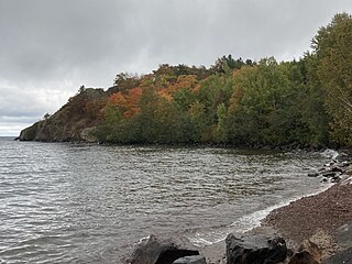
Lake Superior Provincial Park is one of the largest provincial parks in Ontario, covering about 1,550 square kilometres (600 sq mi) along the northeastern shores of Lake Superior between Sault Ste. Marie and Wawa in Algoma District in Northeastern Ontario, Canada. Ontario Highway 17 now runs through the park. When the park was established by Ontario in 1944, there was no road access.

<span class="mw-page-title-main">Pancake Bay Provincial Park</span> Provincial park in Ontario, Canada

Pancake Bay Provincial Park was established in 1968 by Ontario Parks. It is a recreation-class provincial park created to help preserve the fragile beach dune ecology. There are 325 campsites, including 160 with electricity. There are three comfort stations. Yurt camping is available in the park. Group camping sites are also available.

<span class="mw-page-title-main">Charleston Lake Provincial Park</span> Provincial park in Ontario, Canada

Charleston Lake Provincial Park is located on Charleston Lake near Athens, Ontario, Canada, in the township of Leeds and the Thousand Islands.

<span class="mw-page-title-main">Bon Echo Provincial Park</span> Provincial park in Ontario, Canada

Bon Echo Provincial Park is a provincial park in southeastern Ontario, Canada, approximately 6 kilometres (3.7 mi) north of Cloyne. The park is within township boundaries of both North Frontenac and Addington Highlands, roughly separated by Highway 41.

<span class="mw-page-title-main">Long Point Provincial Park</span> Provincial park near Port Rowan, Ontario

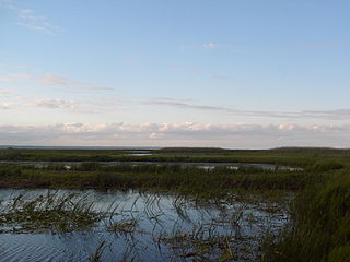
Long Point Provincial Park is a provincial park on the northwest shore of Lake Erie near Port Rowan, Ontario, Canada. The park is part of a sandy spit of land called Long Point that juts out into the lake. It covers part of the area of Long Point Biosphere Reserve, which was designated a UNESCO Biosphere Reserve because of its biological significance.

<span class="mw-page-title-main">Nopiming Provincial Park</span> Provincial park in Manitoba, Canada

Nopiming Provincial Park is a natural provincial park in Manitoba, Canada, located on the southeast side of the province, along the boundary with Ontario.

<span class="mw-page-title-main">Ontario Highway 637</span> Ontario provincial highway

Secondary Highway 637, commonly referred to as Highway 637 is a provincially maintained secondary highway in the Canadian province of Ontario. Located entirely within Sudbury District, the highway connects Highway 69 to the primary townsite of Killarney, 67.7 kilometres (42.1 mi) away, as well as providing access to Killarney Provincial Park.

<span class="mw-page-title-main">La Cloche Silhouette Trail</span>

The La Cloche Silhouette Trail is a 78-kilometre (48 mi) backpacking loop across the white quartzite peaks of the La Cloche mountain range. The trail is situated in Killarney Provincial Park, Ontario, Canada. The trail is named for Group of Seven painter Franklin Carmichael's painting "La Cloche Silhouette." Wildlife can be seen throughout the trail - black bears, moose, wolverines, mountain lions, lynx, fishers, snakes, porcupines, beavers, river otters, among other animals, can be encountered at various points along the way.

<span class="mw-page-title-main">La Cloche Mountains</span> Mountain range in Ontario, Canada

The La Cloche Mountains, also called the La Cloche Range, are a range of mountains in Northern Ontario, Canada, along the northern shore of Lake Huron near Manitoulin Island. The mountains are located in the Canadian Shield, and are composed primarily of white quartzite.

<span class="mw-page-title-main">Pinery Provincial Park</span> Provincial park in Ontario, Canada

Pinery Provincial Park is a provincial park located on Lake Huron near Grand Bend, Ontario. It occupies an area of 25.32 square kilometres. It is a natural environment-class Provincial Park created to help preserve oak savannah and the beach dune ecology. It has 1,275 sites of which 404 have electrical hookups. These include the yurt camping area and the group camping sites.

<span class="mw-page-title-main">Narrow Hills Provincial Park</span> Provincial park in Saskatchewan, Canada

Narrow Hills Provincial Park is a northern boreal forest provincial recreational park in the Canadian province of Saskatchewan. It is located in a hilly plateau called the Cub Hills and contains several recreational facilities and over 25 accessible lakes within its boundaries. The geographical features of the park, including the lakes, valleys, and lowlands were formed over 10,000 years ago during the last ice age. The town of Smeaton is the closest community and it is located 70 kilometres (43 mi) to the south.

<span class="mw-page-title-main">Killarney Provincial Park Observatory</span> Observatory

The Killarney Provincial Park Observatory is an astronomical observatory located at the George Lake Campground of Killarney Provincial Park . The Observatory is operated by Ontario Parks and houses two observatory buildings. The original facility contains a 10" telescope with solar filter, ideal for nighttime as well as daytime viewing of the Sun. The newer facility contains a 16" fully automated telescope with a 5" refractor and is ideal for research, astrophotography and public use. The telescopes are available for Discovery programs as well as private sign-out (self-use) by interested visitors.

<span class="mw-page-title-main">Eastern forest–boreal transition</span> Temperate broadleaf and mixed forest ecoregion in Canada and the United States

The eastern forest–boreal transition is a temperate broadleaf and mixed forests ecoregion of North America, mostly in eastern Canada. It is a transitional zone or region between the predominantly coniferous Boreal Forest and the mostly deciduous broadleaf forest region further south.

Killarney Lakelands and Headwaters Provincial Park is a provincial park in central Ontario, Canada. Located primarily within the Sudbury District with a small portion located in the Walden area of Greater Sudbury, the park was created in 2006 as an expansion of the adjacent Killarney Provincial Park.

<span class="mw-page-title-main">Western Great Lakes forests</span> Temperate broadleaf and mixed forest ecoregion in Canada and the United States

The Western Great Lakes forests is a terrestrial ecoregion as defined by the World Wildlife Fund. It is within the temperate broadleaf and mixed forests biome of North America. It is found in northern areas of the United States' states of Michigan, Wisconsin and Minnesota, and in southern areas of the Canadian province of Manitoba and northwestern areas of the province of Ontario.

<span class="mw-page-title-main">La Cloche Provincial Park</span> Provincial park in Ontario, Canada

La Cloche Provincial Park is a provincial park at the boundary of Algoma and Sudbury Districts in Ontario, Canada. The park consists of an unspoiled section of the La Cloche Mountains that stretch along the North Channel of Georgian Bay, as well as several islands in the channel.

<span class="mw-page-title-main">The Crack (trail)</span>

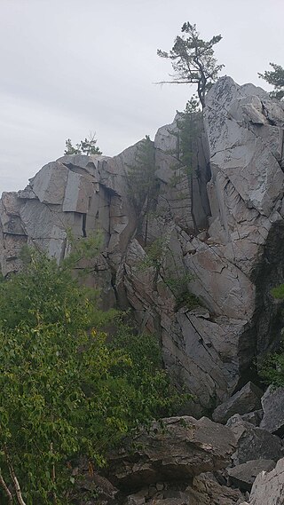
The Crack trail is a 7.5-kilometre out-and-back trail located in Killarney Provincial Park in Ontario, Canada. It is known for the quartzite cliff which creates a formation resembling a crack in the mountain filled with boulders, and the panoramic views of the mountains and lakes at the peak.

References

  1. "Roofed Accommodation - Killarney - Yurts". Ontario Parks.
  2. Olson, D. M, E. Dinerstein; et al. (2001). "Terrestrial Ecoregions of the World: A New Map of Life on Earth". BioScience . 51 (11): 933–938. doi: 10.1641/0006-3568(2001)051[0933:TEOTWA]2.0.CO;2 .{{cite journal}}: CS1 maint: multiple names: authors list (link)