Kinnerly Peak

Last updated
Kinnerly Peak
Kinnerly Peak.jpg
Highest point
Elevation 9,949 ft (3,032 m) [1]  NAVD 88
Prominence 1,465 ft (447 m) [1]
Coordinates 48°57′22″N114°09′55″W / 48.95611°N 114.16528°W / 48.95611; -114.16528 Coordinates: 48°57′22″N114°09′55″W / 48.95611°N 114.16528°W / 48.95611; -114.16528 [2]
Geography
Parent range Livingston Range
Topo map USGS Kintla Peak, MT
Climbing
First ascent 1937 by Norman Clyde, Ed Hall, Richard K. Hill and Braeme Gigos
Easiest route class 4 or easy Class 5

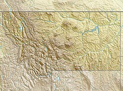
Kinnerly Peak (9,949 ft (3,032 m)) is located in the Livingston Range, Glacier National Park in the U.S. state of Montana. [3] It is approximately 1 mile (1.6 km) north of Kintla Peak, the highest peak in the Livingston Range, and 3 miles (4.8 km) south of the Canada–United States border. Both peaks are in the remote northwest corner of the park. Kinnerly Peak is the eighth tallest peak in Glacier National Park. [1]

Livingston Range mountain in United States of America

The Livingston Range is a mountain range located primarily in Glacier National Park in the U.S. state of Montana, and in the extreme southeastern section of the Canadian province of British Columbia. The range is 36 miles (58 km) long and 28 miles (45 km) wide. Over 15 summits exceed 9,000 ft (2,700 m) above sea level, and the highest point is Kintla Peak at 10,101 feet (3,079 m).

U.S. state constituent political entity of the United States

In the United States, a state is a constituent political entity, of which there are currently 50. Bound together in a political union, each state holds governmental jurisdiction over a separate and defined geographic territory and shares its sovereignty with the federal government. Due to this shared sovereignty, Americans are citizens both of the federal republic and of the state in which they reside. State citizenship and residency are flexible, and no government approval is required to move between states, except for persons restricted by certain types of court orders. Four states use the term commonwealth rather than state in their full official names.

Montana State of the United States of America

Montana is a landlocked state in the Northwestern United States. Montana has several nicknames, although none are official, including "Big Sky Country" and "The Treasure State", and slogans that include "Land of the Shining Mountains" and more recently "The Last Best Place".

Kinnerly Peak is notable for its huge north face, which rises steeply from Upper Kintla Lake. From the lake to the summit is an elevation gain of 5,573 feet (1,699 m) in approximately a horizontal 1 mile (1.6 km).

Upper Kintla Lake is located in Glacier National Park, in the U. S. state of Montana. Upper Kintla Lake is 2 miles (3.2 km) east of Kintla Lake and the surrounding mountains rise dramatically above the north and south shores of the lake. Kinnerly Peak rises 5,575 feet (1,699 m) above the south shoreline of Upper Kintla Lake while Long Knife Peak towers more than 5,400 feet (1,600 m) above the northwest shoreline of the lake.

The first recorded ascent of Kinnerly Peak was made by a Sierra Club party led by the noted mountaineer Norman Clyde, in 1937. [4] The standard climbing route ascends the northwest face, starting from the south shore of Upper Kintla Lake. It involves a large amount of elevation gain, mostly by scrambling, but with some exposed and mildly technical sections (Class 4 or easy Class 5). Other routes exist on the southeast and southwest faces. [5] :84–89

Sierra Club environmental organization

The Sierra Club is an environmental organization in the United States. It was founded on May 28, 1892, in San Francisco, California, by the Scottish-American preservationist John Muir, who became its first president. The Sierra Club primarily operates in the United States; an affiliated organization, Sierra Club Canada, operates in Canada and deals exclusively with Canadian issues.

Norman Clyde American mountain climber

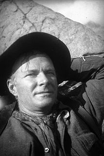
Norman Clyde was a mountaineer, mountain guide, freelance writer, nature photographer, and self trained naturalist. He is well known for achieving over 130 first ascents, many in California's Sierra Nevada and Montana's Glacier National Park. He also set a speed climbing record on California's Mount Shasta in 1923. The Bancroft Library at the University of California, Berkeley has 1467 articles written by Clyde in its archives.

Grade (climbing) degree of difficulty of a climbing route

In rock climbing, mountaineering, and other climbing disciplines, climbers give a grade to a climbing route or boulder problem, intended to describe concisely the difficulty and danger of climbing it. Different types of climbing each have their own grading systems, and many nationalities developed their own, distinctive grading systems.

See also

Related Research Articles

Longs Peak mountain

Longs Peak is a high and prominent mountain summit in the northern Front Range of the Rocky Mountains of North America. The 14,259-foot (4346 m) fourteener is located in the Rocky Mountain National Park Wilderness, 9.6 miles (15.5 km) southwest by south of the Town of Estes Park, Colorado, United States. Longs Peak is the northmost "fourteener" in the Rocky Mountains and the highest point in Boulder County and Rocky Mountain National Park. The mountain was named in honor of explorer Stephen Harriman Long and is featured on the Colorado state quarter.

Glacier National Park (U.S.) national park located in the U.S. state of Montana

Glacier National Park is an American national park located in northwestern Montana, on the Canada–United States border, adjacent to the Canadian provinces of Alberta and British Columbia. The park encompasses over 1 million acres (4,000 km2) and includes parts of two mountain ranges, over 130 named lakes, more than 1,000 different species of plants, and hundreds of species of animals. This vast pristine ecosystem is the centerpiece of what has been referred to as the "Crown of the Continent Ecosystem," a region of protected land encompassing 16,000 square miles (41,000 km2).

Crestone Peak mountain in United States of America

Crestone Peak is the seventh-highest summit of the Rocky Mountains of North America and the U.S. state of Colorado. The prominent 14,300-foot (4,359 m) fourteener is the highest summit of the Crestones and the second-highest summit in the Sangre de Cristo Range after Blanca Peak. The summit is located in the Sangre de Cristo Wilderness of Rio Grande National Forest, 5.0 miles (8.1 km) east by south of the Town of Crestone in Saguache County, Colorado, United States.

Absaroka-Beartooth Wilderness

Absaroka-Beartooth Wilderness was created from existing National Forest lands in 1978 and is located in Montana and Wyoming, United States. The wilderness is partly in Gallatin, Custer and Shoshone National Forests and is composed of 944,000 acres (3,820 km2). The wilderness encompasses two distinct mountain ranges, namely the Beartooth and Absaroka ranges. These ranges are completely distinct geologically speaking with the Absarokas composed primarily of volcanic and metamorphic rock, while the Beartooths are made up almost entirely of granitic rocks. The Absarokas are noted for their dark and craggy appearance, lush and heavily forested valleys and abundant wildlife. The highest peak in the range, located in Wyoming, is Francs Peak at 13,153 feet (4,009 m). The Beartooths are more alpine with huge treeless plateaus and the highest peak in the state of Montana. The wilderness contains 30 peaks over 12,000 feet (3,700 m). The wilderness is an integral part of the 20-million-acre (81,000 km2) Greater Yellowstone Ecosystem and borders Yellowstone National Park.

Mount Stimson mountain in United States of America

Mount Stimson is the second highest peak in Glacier National Park, located in Montana, United States. It is part of the Lewis Range, which spans much of the park. It is located in the remote southwestern portion of the park, approximately 5 miles (8.0 km) west of the Continental Divide and 12 miles (19 km) southeast of Lake McDonald. It is drained by Pinchot Creek and Nyack Creek, both of which flow into the Middle Fork of the Flathead River. The mountain is named for Henry L. Stimson (1867–1950), former U.S. Secretary of State and twice Secretary of War, who hiked and assisted George Bird Grinnell survey the area in and around Glacier National Park in the 1890s, and supported efforts to establish the national park.

Mount Cleveland (Montana) mountain in United States of America

Mount Cleveland is the highest mountain in Glacier National Park, located in Montana, United States. It is also the highest point in the Lewis Range, which spans part of the northern portion of the Park and extends into Canada. It is located approximately 3 mi (4.8 km) southeast of the southern end of Waterton Lake, and approximately 5 mi (8.0 km) south of the US/Canada border. The east side of the future national park was purchased by the federal government from the Blackfoot Confederacy in 1895 during the second term of President Cleveland. According to the United States Board on Geographic Names, the mountain is named for the former president.

Heavens Peak mountain in United States of America

Heavens Peak is located in the Livingston Range, Glacier National Park in the U.S. state of Montana. Heavens Peak is a little more than 1 mile (1.6 km) north of McPartland Mountain.

Anaconda-Pintler Wilderness

The Anaconda-Pintler Wilderness is located in southwestern Montana, in the northwestern United States. It runs for 40 miles (65 km) along both sides of the crest of the Anaconda Range, covering almost 250 square miles (640 km2). To the north are the Sapphire Mountains, and to the south is the Big Hole Valley. Elevations range from about 5000 feet up to 10,793 feet at West Goat Peak. West Pintler Peak, located in a more commonly visited area, rises to 9894 feet. Visitors can most easily access this area via trailheads at Pintler Lake to the south, and at Lutz Creek and Moose Lake to the north. The wilderness lies in parts of Deer Lodge, Granite, Ravalli, and Beaverhead counties.

Kintla Peak mountain in United States of America

Kintla Peak is part of the Livingston Range in Glacier National Park in the U.S. state of Montana. It is the tallest mountain in the Livingston Range and the third tallest in Glacier National Park. The Agassiz Glacier lies below it to the southeast.

Clouds Rest mountain

Clouds Rest is a mountain in Yosemite National Park east northeast of Yosemite Village, California. Although there are many peaks in the park having far greater elevation, Clouds Rest's proximity to the valley gives it a very high degree of visual prominence.

Babb, Montana Census-designated place in Montana, United States

Babb is a small unincorporated farming and ranching community in Glacier County, Montana, United States, on the Blackfeet Indian Reservation. The community experiences a large influx of tourist in the summer months as it is the gateway to the Many Glacier area of Glacier National Park. Babb is a census-designated place (CDP) and had a population of 174 at the 2010 census.

Outline of Glacier National Park (U.S.)

The following articles relate to the history, geography, geology, flora, fauna, structures and recreation in Glacier National Park (U.S.), the U.S. portion of the Waterton-Glacier International Peace Park.

Long Knife Peak mountain in Canada

Long Knife Peak is located in the Clark Range, Glacier National Park in the U.S. state of Montana. Though much of the mountain slopes extend into the Canadian Province of British Columbia, the main summit is in the U.S. Long Knife Peak rises more than a vertical 1 mile (1.6 km) above Upper Kintla Lake.

Numa Peak mountain in United States of America

Numa Peak is located in the Livingston Range, Glacier National Park in the U.S. state of Montana. The small Baby Glacier is below the peak to the immediate northeast. Numa Peak is the high point along Numa Ridge and rises almost 5,000 feet (1,500 m) above Bowman Lake.

Parke Peak mountain in United States of America

Parke Peak is located in the Livingston Range, Glacier National Park in the U.S. state of Montana. Harris Glacier is immediately northeast of Parke Peak.

Rainbow Peak mountain in United States of America

Rainbow Peak is located in the Livingston Range, Glacier National Park in the U.S. state of Montana. The namesake Rainbow Glacier is immediately east and northeast of Rainbow Peak. Rainbow Peak is the ninth-tallest mountain in Glacier National Park and rises over 1 mile (1.6 km) above Bowman Lake. From the parking lot at the Bowman Lake Campground, the elevation gain is 5,865 ft (1,788 m).

Reuter Peak mountain in United States of America

Reuter Peak is located in the Livingston Range, Glacier National Park in the U.S. state of Montana.

Kintla Glacier glacier in the United States

Kintla Glacier is in Glacier National Park in the U.S. state of Montana. The glacier is situated on a plateau 2 miles (3.2 km) southwest of Kintla Peak at an elevation between 8,700 feet (2,700 m) and 7,700 feet (2,300 m) above sea level. The glacier has numerous crevasses and is actually two glaciers with a combined area of 280 acres (110 ha) as of 2005. This is a 34 percent decrease in area from 1966.

References

  1. 1 2 3 "Kinnerly Peak, Montana". Peakbagger.com. Retrieved 2010-08-08.
  2. "Kinnerly Peak". Geographic Names Information System . United States Geological Survey . Retrieved 2010-08-08.
  3. "Kinnerly Peak, Montana" (Map). TopoQuest (USGS Quad). Retrieved 2010-08-08.
  4. Los Angeles Times September 12, 1937, p. G2
  5. Edwards, J. Gordon (1995). A Climber's Guide to Glacier National Park. Falcon Press. ISBN   0-87842-177-7.