
Jajce is a small city in Bosnia & Herzegovina, central not only geographically but also culturally. Throughout Bosnia's long history, Jajce has been the home of medieval kings, Ottoman governors, and a range of different ethnic groups, as well as being one of President Tito's earliest Communist strongholds. Jajce has been so far undiscovered by tourists, although UNESCO has recently been investing in renovating the city's historical areas,Town and municipality located in the Central Bosnia Canton of the Federation of Bosnia and Herzegovina, an entity of Bosnia and Herzegovina. According to the 2013 census, the town has a population of 7,172 inhabitants, with 27,258 inhabitants in the municipality, It is situated in the region of Bosanska Krajina, on the crossroads between Banja Luka, Mrkonjić Grad and Donji Vakuf, on the confluence of the rivers Pliva and Vrbas.

Zenica is a city in Bosnia and Herzegovina and an administrative and economic center of the Federation of Bosnia and Herzegovina's Zenica-Doboj Canton. It is located in the Bosna river valley, about 70 km (43 mi) north of Sarajevo. The city is known for its Ironworks Zenica factory but also as a significant university center. According to the 2013 census, the settlement of Zenica itself counts 70,553 citizens and the administrative area 110,663, making it the nation's fourth-largest city.

Vogošća is a town and a municipality located in Sarajevo Canton of the Federation of Bosnia and Herzegovina, an entity of Bosnia and Herzegovina. The municipality is located about 6 kilometers north of the city of Sarajevo and is its secondary suburb, after Ilidža. According to the 2013 census, the town has a population of 10,568 inhabitants, with 26,343 inhabitants in the municipality.

Novi Grad is a municipality of the city of Sarajevo, Bosnia and Herzegovina. It is the westernmost of the four municipalities that make up the city of Sarajevo. The municipality also consists of the villages Bojnik and Rečica.

The Central Bosnia Canton is one of 10 cantons of the Federation of Bosnia and Herzegovina in Bosnia and Herzegovina.

Visoko is a city located in the Zenica-Doboj Canton of the Federation of Bosnia and Herzegovina, an entity of Bosnia and Herzegovina. As of 2013, the municipality had a population of 39,938 inhabitants with 11,205 living in Visoko town. Located between Zenica and Sarajevo, Visoko lies where the river Fojnica joins the Bosna.

Kakanj is a town and municipality located in Zenica-Doboj Canton of the Federation of Bosnia and Herzegovina, an entity of Bosnia and Herzegovina. As of 2013, the town has a population of 11,796 inhabitants, with 38,937 inhabitants in the municipality. It is situated in central Bosnia and Herzegovina, north of Visoko and southeast of Zenica. It was built along the slopes of wide hills on either side of the Zgošća river.

Hadžići is a town and municipality located in Sarajevo Canton of the Federation of Bosnia and Herzegovina, an entity of Bosnia and Herzegovina. It is located south west of the city of Sarajevo. According to the 2013 census, Hadžići municipality has a population of 23,891 residents and the town had 4,993.
Ilijaš is a town and municipality located in Sarajevo Canton of the Federation of Bosnia and Herzegovina, an entity of Bosnia and Herzegovina. It is located northwest of the inner city of Sarajevo and was established in May 1952 with the organization of people's committees. Those local people's committees founded the local municipalities, which led to the self-management of the municipalities, including the municipality of Ilijaš.
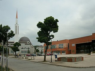
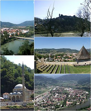
Fojnica is a town and municipality located in Central Bosnia Canton of the Federation of Bosnia and Herzegovina, an entity of Bosnia and Herzegovina. It is located west of the capital Sarajevo, in the valley of the Fojnička River, tributary of the river Bosna. Fojnica is a small town in central Bosnia and is also a balneological resort.
Srebrenik is a city located in Tuzla Canton of the Federation of Bosnia and Herzegovina. It is located in northeastern Bosnia and Herzegovina, near Tuzla. As of 2013, it had a population of 39,678 inhabitants. The town of Srebrenik had a population of 6,694.

Vareš is a town and municipality located in Zenica-Doboj Canton of the Federation of Bosnia and Herzegovina, an entity of Bosnia and Herzegovina. It is situated in central Bosnia and Herzegovina, and is famous for the local mining activities and production of iron. As of 2013, it has a population of 8,892 inhabitants, with 2,917 in the town itself.

Kupres is a town and the seat of the Municipality of Kupres in Canton 10 of the Federation of Bosnia and Herzegovina, an entity of Bosnia and Herzegovina. As of 2013, it has a population of 5,057 inhabitants, while the town of Kupres has a population of 2,883 inhabitants.
Maglaj is a town and municipality located in the Zenica-Doboj Canton of the Federation of Bosnia and Herzegovina, an entity of Bosnia and Herzegovina. It is located in northern Bosnia and Herzegovina, 25 km (16 mi) south of Doboj. It has a population of 6,438, with 34,980 inhabitants in the municipality.

The Croats of Bosnia and Herzegovina, often referred to as Bosnian Croats or Herzegovinian Croats, are native and the third most populous ethnic group in Bosnia and Herzegovina, after Bosniaks and Serbs, and are one of the constitutive nations of Bosnia and Herzegovina. Croats of Bosnia and Herzegovina have made significant contributions to the culture of Bosnia and Herzegovina. Most Croats declare themselves Catholics and speakers of the Croatian language.

The Lašva Valley ethnic cleansing, also known as the Lašva Valley case, refers to numerous war crimes committed during the Bosnian war by the Croatian Community of Herzeg-Bosnia's political and military leadership on Bosniak or Bosnian Muslim civilians in the Lašva Valley region of Bosnia-Herzegovina. The campaign, planned from May 1992 to March 1993 and erupting the following April, was meant to implement objectives set forth by Croat nationalists in November 1991. The Lašva Valley's Bosniaks were subjected to persecution on political, and religious grounds, deliberately discriminated against in the context of a widespread attack on the region's civilian population and suffered mass murder, rape and wartime sexual violence, imprisonment in camps, as well as the destruction of religious and cultural sites and private property. This was often followed by anti-Bosniak propaganda, particularly in the municipalities of Vitez, Busovača, Novi Travnik and Kiseljak.

The Croat–Bosniak War was a conflict between the Republic of Bosnia and Herzegovina and the Republic of Herzeg-Bosnia, supported by Croatia, that lasted from 18 October 1992 to 23 February 1994. It is often referred to as a "war within a war" because it was part of the larger Bosnian War. In the beginning, the Army of the Republic of Bosnia and Herzegovina and the Croatian Defence Council (HVO) fought together in an alliance against the Yugoslav People's Army (JNA) and the Army of Republika Srpska (VRS). By the end of 1992, however, tensions between Bosniaks and Bosnian Croats increased. The first armed incidents between them occurred in October 1992 in central Bosnia. The military alliance continued until early 1993, when it mostly fell apart and the two former allies engaged in open conflict.

The Croat–Bosniak War was a conflict between the Republic of Bosnia and Herzegovina and the Croatian Community of Herzeg-Bosnia, supported by Croatia, that lasted from 19 June 1992 – 23 February 1994. The Croat-Bosniak War is often referred to as a "war within a war" because it was part of the larger Bosnian War.
Višnjica may refer to several places:
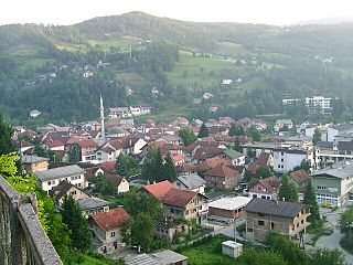
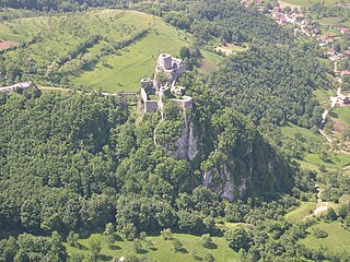
Kaštela or Kaštele is a cliff-hanging fortress built above the village of Rizvići, Fojnica, Bosnia and Herzegovina. The fortress is suspended against the cliffs of mount Zahor. It dates from the Middle Ages, from the time of the medieval Bosnian state.


