This page is based on this
Wikipedia article Text is available under the
CC BY-SA 4.0 license; additional terms may apply.
Images, videos and audio are available under their respective licenses.

Tang is a full village and a half-parish in County Westmeath, on the N55 national secondary road between Athlone and Ballymahon, County Longford. Tang is in the parish of Drumraney. Tang is in County Westmeath but on the border with County Longford from which it is separated by the River Tang which flows into Lough Ree 3 km downstream via the River Inny.

Raharney is a village in east County Westmeath, Ireland. It has a population of 227.

Street, or Streete is a village and parish in County Westmeath, Ireland. It lies on the regional road between Lismacaffery and Rathowen. Its Irish name was historically anglicised as Straid and Strade.

Tubberclare or Tubberclair is a place in County Westmeath, Ireland, between Ballymahon and Athlone. It lies 9 km (6 mi) from Athlone, on the N55 national secondary road, and 2 km (1 mi) north of Glasson.

Moycashel, previously the barony of Rossaughe, before that, Delamares country, is a barony in south County Westmeath, in the Republic of Ireland. It was formed by 1542. It is bordered by three other baronies: Clonlonan to the west, Rathconrath to the north, Moyashel and Magheradernon to the north-east and Fartullagh to the west. The largest population centre is Kilbeggan.

Fore is a barony in northern County Westmeath, Ireland. It was formed by 1672.

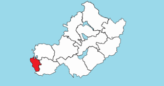
Kilkenny West, previously Maherquirke or Dillons country, is a barony in west County Westmeath, Ireland. It was formed by 1542. It is bordered by County Longford to the west; it is also bordered by three other Westmeath baronies: Rathconrath, Brawny and Clonlonan. The largest centre of population in the barony is the village of Glassan.

Brawny is a barony in south–west County Westmeath, Ireland. It was formed by 1672. It is bordered by County Roscommon to the west. It also borders two other Westmeath baronies: Kilkenny West and Clonlonan. The largest centre of population in the barony is the town of Athlone.

Clonlonan is a barony in south–west County Westmeath, Ireland. It was formed by 1672. It is bordered by County Offaly to the south and a small part of County Roscommon at Long Island on the River Shannon to the west. It also borders four other Westmeath baronies: Kilkenny West and Rathconrath, Moycashel and Brawny. The largest centre of population in the barony is the town of Moate.

Ballynafid is a townland in County Westmeath, Ireland. It is located about 10 kilometres (6 mi) north–west of Mullingar. This place name is not to be confused with Ballinafid and Ballinafid Lake which are in the neighbouring townland of Knightswood.

Culleenabohoge is a townland in County Westmeath, Ireland. It is located about 9.7 kilometres (6 mi) north–north–west of Mullingar.

Culleendarragh is a townland in County Westmeath, Ireland. It is located about 10 kilometres (6 mi) north–north–west of Mullingar.

Leny is a civil parish in County Westmeath, Ireland. It is located about 10.5 kilometres (7 mi) north–west of Mullingar. This name also applies to the townland of Leny; neither should be confused with the Falls of Leny in Scotland.

Portnashangan is a townland in County Westmeath, Ireland. It is located about 6.81 kilometres (4 mi) north–north–west of Mullingar.

Rathlevanagh is a townland in County Westmeath, Ireland. It is located about 7.5 kilometres (5 mi) north of Mullingar.

Down is a townland in County Westmeath, Ireland. It is located about 8.17 kilometres (5 mi) north of Mullingar.

Tyfarnham is a townland in County Westmeath, Ireland. It is located about 9.4 kilometres (6 mi) north of Mullingar.


