This article may be in need of reorganization to comply with Wikipedia's layout guidelines .(May 2017) |
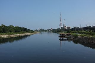
Kosasthalaiyar River, also known as Kortalaiyar, is one of the three rivers that flow in the Chennai metropolitan area.
This article may be in need of reorganization to comply with Wikipedia's layout guidelines .(May 2017) |
Kosasthalaiyar River, also known as Kortalaiyar, is one of the three rivers that flow in the Chennai metropolitan area.
Kosasthalaiyar is 136-kilometre (85 mi) long and originates near Pallipattu in Thiruvallur district and drains into the Bay of Bengal. Its northern tributary Nagari river originates in Chitoor district of Andhra Pradesh and joins the main river in the backwaters of Poondi reservoir. Its catchment area is spread over Vellore, Chitoor, North Arcot, Thiruvallur and Chennai districts. It has a catchment area in North Arcot District where it branches near Kesavaram Anicut and this tributary flows to the Chennai city as Cooum River, while the main river flows to the Poondi reservoir. From Poondi reservoir, the river flows through Thiruvallur District, enters the Chennai metropolitan area, and joins the sea at Ennore Creek. The river has 9 check dams. There are two check dams across the river at Tamaraipakkam and Vallur. [1] The excess discharge in the river is controlled by the Tamarapakkam Anicut [2] located across the river in the downstream of Poondi reservoir. Vallur Anicut is a small check dam constructed near Minjur across the river to control water levels and feed irrigation channels in the area. It flows to a distance of 16 kilometres (10 mi) in the Chennai metropolitan area. The total catchment area of the river is 3,757 kilometres (2,334 mi), and the bed width ranges from 150 to 250 metres (490 to 820 ft). The discharge capacity of the river is 110,000 cubic metres per second (3,900,000 cu ft/s), and the anticipated flood discharge capacity is about 125,000 cubic metres per second (4,400,000 cu ft/s). [3] The river drains up to 50,000 cubic feet per second (1,400 m3/s) of flood water into the sea through the Ennore Creek during monsoons. [4]
Galeru Nagari irrigation project is under execution to supply Krishna river water from Srisailam reservoir in Nagari basin of Chitoor district.
Every year, whenever the floodgates of Poondi reservoir are opened, a considerable volume of water gets drained into the sea through the Kosasthalaiyar River near the Ennore Creek.
Work on 10th check dam across the river is expected to by completed by the end of 2018 at a cost of ₹ 70 million. The structure would be 1.5 meters high, built across the 100-meter wide river. It would store water in the river for over 2 kilometers. [5]
The historic Korattur anicut located at Jamin Korattur in Tiruvallur district serves as a vital channel to regulating water to the Chembarambakkam reservoir. The dam was built in 1876 across the unpolluted stretch of the Cooum river and diverts excess water to the Chembarambakkam reservoir. [6]
In 2011, the Water Resources Department (WRD) initiated the tendering process under the Irrigated Agriculture Modernisation and Waterbodies Restoration and Management (IAMWARM) project to rejuvenate nearly 200 lakes falling under Kosasthalaiyar river sub-basin. [7] The department also proposes to construct groynes to reduce formation of sand bars near the mouth the river. [8]
In May 2012, the Water Resources Department (WRD) planned to construct a check dam across the river near Bandikavanur village in Tiruvallur district, about 30 kilometres (19 mi) from Chennai, at a cost of ₹ 300 million. The Bandikavanur check dam, to be constructed about 500 metres (1,600 ft) upstream of the Karanodai bridge on Chennai–Kolkata National Highway, would be constructed at a height of 6.3 metres (21 ft) across the nearly 300-metre (980 ft) wide river. The check dam would recharge the water table at a radius of 10 kilometres (6 mi). [1] [9]
In 2018, two more check-dams were planned across the river. One of them will be located between Pudhukuppam and Kudiraipallam, downstream of Karanodai bridge. The dam will be built to a height of 1.2 meters across the river and the width will be nearly 335 meters, at a cost of ₹ 99 million. This will be the eighth check-dam built across the river. Another one will be built in Bandikavanur, about 30 km from Chennai. This will help recharge groundwater in a radius of 10 km. [6]

The Buckingham Canal is a 796 kilometres (494.6 mi)-long fresh water navigation canal, that parallels the Coromandel Coast of South India from Kakinada City in the Kakinada district of Andhra Pradesh to Viluppuram District in Tamil Nadu. The canal connects most of the natural backwaters along the coast to Chennai (Madras) port.

Palar is a river of southern India. It rises in the Nandi Hills in Chikkaballapura district of Karnataka state, and flows 93 kilometres (58 mi) in Karnataka, 33 kilometres (21 mi) in Andhra Pradesh and 222 kilometres (138 mi) in Tamil Nadu before reaching its confluence into the Bay of Bengal at Vayalur about 75 kilometres (47 mi) south of Chennai. It flows as an underground river for a long distance only to emerge near Bethamangala town, from where, gathering water and speed, it flows eastward down the Deccan Plateau. The Towns of Bethamangala, Santhipuram, Kuppam, Ramanaickenpet, Vaniyambadi, Ambur, Melpatti, Gudiyatham, Pallikonda, Anpoondi, Melmonavoor, Vellore, Katpadi, Melvisharam, Arcot, Ranipet, Walajapet, Kanchipuram, Walajabad, Chengalpattu, Kalpakkam, and Lattur are located on the banks of the Palar River. Of the seven tributaries, the chief tributary is the Cheyyar River.
The Cooum river, or simply Koovam, is one of the shortest classified rivers draining into the Bay of Bengal. This river is about 72 km (45 mi) in length, flowing 32 km (20 mi) in the city of Chennai and the rest in rural part. The river is highly polluted in the urban area (Chennai). Along with the Adyar River running parallel to the south and the Kosasthalaiyar River, the river trifurcates the city of Chennai and separates Northern Chennai from Central Chennai. It is also sometimes known as Thiruvallikenni river

Chembarambakkam lake is a lake located in Chennai, Tamil Nadu, India, about 25 km from Chennai. It is one of the two rain-fed reservoirs from where water is drawn for supply to Chennai City, the other one being the Puzhal Lake. The Adyar River originates from this lake. A part of water supply of the metropolis of Chennai is drawn from this lake. This was the first Artificial lake built by Rajendra Chola I the son of Rajaraja Chola and Thiripuvana Madeviyar, prince of Kodumbalur.

Sholavaram aeri, or Sholavaram lake, is located in Ponneri taluk of Thiruvallur district, Tamil Nadu, India. It is one of the rain-fed reservoirs from where water is drawn for supply Chennai city from this lake to Puzhal lake through canals.
Pulhal aeri, or Pulhal lake, sometimes spelled Puzhal lake, also known as the Red Hills Lake, is located in Red Hills, Chennai, India. It lies in Thiruvallur district of Tamil Nadu state. It is one of the two rain-fed reservoirs from where water is drawn for supply to Chennai City, the other one being the Chembarambakkam Lake and Porur Lake.

The Thamirabarani or Tamraparni or Porunai is a perennial river that originates from the Agastyarkoodam peak of Pothigai hills of the Western Ghats, above Papanasam in the Ambasamudram taluk. It flows through Tirunelveli and Thoothukudi districts of the Tamil Nadu state of southern India into the Gulf of Mannar. It was called the Tamraparni River in the pre-classical period, a name it lent to the island of Sri Lanka. The old Tamil name of the river is Porunai. From the source to sea, the river is about 128 kilometres (80 mi) long and is the only perennial river in Tamil Nadu. This river flows towards north direction initially. However, it changes to east direction later.
Kangsabati River (Pron:) rises from the Chota Nagpur plateau in the state of West Bengal, India and passes through the districts of Purulia, Bankura, Paschim Medinipur and Purba Medinipur in West Bengal before draining in the Bay of Bengal.

Chennai is located at 13.04°N 80.17°E on the southeast coast of India and in the northeast corner of Tamil Nadu. It is located on a flat coastal plain known as the Eastern Coastal Plains. The city has an average elevation of 6 metres (20 ft), its highest point being 60 m (200 ft). Chennai is 2,184 kilometres south of Delhi, 1,337 kilometres southeast of Mumbai, and 1,679 kilometers southwest of Kolkata by road.

The Telugu Ganga project is a joint water supply scheme implemented in 1980s by the then Andhra Pradesh chief minister N.T.Ramarao and Tamilnadu Chief minister M. G. Ramachandran to provide drinking water to Chennai city in Tamil Nadu. It is also known as the Krishna Water Supply Project, since the source of the water is the Krishna river in erstwhile Andhra Pradesh. Water is drawn from the Srisailam reservoir and diverted towards Chennai through a series of inter-linked canals, over a distance of about 406 kilometres (252 mi), before it reaches the destination at the Poondi reservoir near Chennai. The main checkpoints en route include the Somasila reservoir in Penna River valley, the Kandaleru reservoir, the 'Zero Point' near Uthukkottai where the water enters Tamil Nadu territory and finally, the Poondi reservoir, also known as Satyamurthy Sagar. From Poondi, water is distributed through a system of link-canals to other storage reservoirs located at Red Hills, Sholavaram and Chembarambakkam.

Ennore, also spelt Eṇṇūr, is a neighbourhood in Chennai, India. Ennore is situated on a peninsula and is bounded by the Korttalaiyar River, Ennore Creek and the Bay of Bengal. The creek separates south Ennore from the north Ennore which covers major portions of North Chennai Thermal Power Station and Ennore Port. The neighbourhood is served by Ennore railway station. Over the years Ennore has become the hub of a range of industrial projects, mainly thermal power stations, fertilizer factories, industrial ports and coal yards.

Ambattur aeri, or Ambattur lake, is a rain-fed reservoir which reaches top levels during the monsoon seasons. In November 2008, incessant monsoon rain filled the lake and encroachments on the north and south banks of the lake were demolished. It also caters to the drinking water needs of the Chennai city after Poondi and Chembarambakkam Lake.
Rettai Eri, locally known as Retteri, is a lake in the Kolathur area of Chennai, India which is visible from the 100 ft road. Redhills road Junction is also named as Retteri Junction. The Government has planned to construct a flyover at this junction.

The Adyar River, originating near the Chembarambakkam Lake in Kanchipuram district, is one of the three rivers which winds through Chennai (Madras), Tamil Nadu, India, and joins the Bay of Bengal at the Adyar estuary. The 42.5-kilometre (26.4 mi) long river contributes to the estuarine ecosystem of Chennai. Despite the high pollution levels, boating and fishing take place in this river. The river collects surplus water from about 200 tanks and lakes, small streams and the rainwater drains in the city, with a combined catchment area of 860 square kilometres (331 sq mi). Most of the waste from the city is drained into this river and the Cooum.
Chennai Metropolitan Water Supply and Sewerage Board, known shortly as CMWSSB, is a statutory board of Government of Tamil Nadu which provides water supply and sewage treatment to the city of Chennai and its metropolitan region.
Ennore Creek is a backwater located in Ennore, Chennai along the Coromandel Coast of the Bay of Bengal. It is located in the zone comprising lagoons with salt marshes and backwaters, submerged under water during high tide and forming an arm of the sea with the opening to the Bay of Bengal at the creek. The zone is spread over an area of 4 km2, and the creek covers an area of 2.25 km2. It is located 20 km north of the city centre and 2.6 km south of the Ennore Port, and the creek area stretches 3 km into the sea and 5 km along the coast. The creek is nearly 400 m wide, elongated in northeast–southwest direction and merging with the backwater bodies. Once a flourishing mangrove swamp, the creek has been degraded to patches in the fringes mainly due to human activities in the region. The depth of the creek varies from 1 to 2 m and is shallow near the mouth. The north–south trending channels of the creek connect it with the Pulicat Lake to the north and to the distributaries of the Kosasthalaiyar River in the south. The northwestern part of the creek merges with the tidal flats. The soil in the region is of loamy and alluvial types. Most of the area consists of tracts of alluvial soil and the eastern region comprises beach dunes, tidal flats and creek. The creek is oriented from west to east and opens into the Bay of Bengal to the east at Ennore. The creek acts as an outlet for the excess water from the Poondi reservoir. The creek separates the town of Ennore from the Ennore Port located in the north and the Kattupalli Shipyard located further north. The North Chennai Thermal Power Station is located at the north of the creek and the Ennore Thermal Power Station is located to the south. The creek is part of the Pulicat water system, including the Pulicat lagoon and the Buckingham Canal. As per the 1991 Coastal Regulation Zone notification, the entire Pulicat water system is designated CRZ I. The creek is experiencing siltation due to emergence of the Ennore Port.
Velugodu Reservoir is a balancing reservoir and located across the Galeru river, a tributary of Kundu River in Penner River basin, at Velugodu town in Nandyal district of Andhra Pradesh. This reservoir is part of Telugu Ganga project and mainly fed by gravity canal from back waters of Srisailam Dam through Pothireddypadu head / flow regulator located across the feeder canal. Velugodu Reservoir has gross storage capacity of 16.95Tmcft at 265 m MSL full reservoir level.
The coastal city of Chennai has a metropolitan population of 10.6 million as per 2019 census. As the city lacks a perennial water source, catering the water requirements of the population has remained an arduous task. On 18 June 2019, the city's reservoirs ran dry, leaving the city in severe crisis.

Poondi Reservoir or Sathyamoorthy reservoir is the reservoir across Kotralai River in Tiruvallur district of Tamil Nadu State. It acts as the important water source for Chennai city which is 60 km away.
Arani, also known as Araniar or Araniyar, is a 108 km long river in India. It flows through the states of Tamil Nadu and Andhra Pradesh.
Coordinates: 13°12′46″N80°16′37″E / 13.212822°N 80.27696°E