Gmina Czorsztyn is a rural gmina in Nowy Targ County, Lesser Poland Voivodeship, in southern Poland, on the Slovak border. It takes its name from the village of Czorsztyn, its former seat. The present seat of the gmina is Maniowy, which lies approximately 19 kilometres (12 mi) east of Nowy Targ and 71 km (44 mi) south of the regional capital Kraków.
Gmina Haczów is a rural gmina in Brzozów County, Subcarpathian Voivodeship, in south-eastern Poland. Its seat is the village of Haczów, which lies approximately 10 kilometres (6 mi) west of Brzozów and 42 km (26 mi) south of the regional capital Rzeszów.
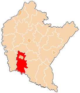
Gmina Korczyna is a rural gmina in Krosno County, Subcarpathian Voivodeship, in south-eastern Poland. Its seat is the village of Korczyna, which lies approximately 7 kilometres (4 mi) north-east of Krosno and 38 km (24 mi) south of the regional capital Rzeszów.
Gmina Krościenko Wyżne is a rural gmina in Krosno County, Subcarpathian Voivodeship, in south-eastern Poland. Its seat is the village of Krościenko Wyżne, which lies approximately 5 kilometres (3 mi) east of Krosno and 42 km (26 mi) south of the regional capital Rzeszów.
Gmina Miejsce Piastowe is a rural gmina in Krosno County, Subcarpathian Voivodeship, in south-eastern Poland. Its seat is the village of Miejsce Piastowe, which lies approximately 7 kilometres (4 mi) south-east of Krosno and 48 km (30 mi) south of the regional capital Rzeszów. The current mayor Marek Klara was elected in 2006.

Leśniówka is a village in the administrative district of Gmina Chorkówka, within Krosno County, Subcarpathian Voivodeship, in south-eastern Poland. It lies approximately 5 kilometres (3 mi) north-west of Chorkówka, 9 km (6 mi) west of Krosno, and 49 km (30 mi) south-west of the regional capital Rzeszów.
Cergowa is a village in the administrative district of Gmina Dukla, within Krosno County, Subcarpathian Voivodeship, in south-eastern Poland, close to the border with Slovakia. It lies approximately 3 kilometres (2 mi) south-east of Dukla, 16 km (10 mi) south of Krosno, and 58 km (36 mi) south of the regional capital Rzeszów.
Iwla is a village in the administrative district of Gmina Dukla, within Krosno County, Subcarpathian Voivodeship, in south-eastern Poland, close to the border with Slovakia. It lies approximately 5 kilometres (3 mi) west of Dukla, 17 km (11 mi) south-west of Krosno, and 60 km (37 mi) south-west of the regional capital Rzeszów.
Jasionka is a village in the administrative district of Gmina Dukla, within Krosno County, Subcarpathian Voivodeship, in south-eastern Poland, close to the border with Slovakia. It lies approximately 5 kilometres (3 mi) south-east of Dukla, 15 km (9 mi) south of Krosno, and 58 km (36 mi) south of the regional capital Rzeszów.
Nowa Wieś is a village in the administrative district of Gmina Dukla, within Krosno County, Subcarpathian Voivodeship, in south-eastern Poland, close to the border with Slovakia. It lies approximately 5 kilometres (3 mi) south of Dukla, 18 km (11 mi) south of Krosno, and 61 km (38 mi) south of the regional capital Rzeszów.
Równe is a village in the administrative district of Gmina Dukla, within Krosno County, Subcarpathian Voivodeship, in south-eastern Poland, close to the border with Slovakia. It lies approximately 5 kilometres (3 mi) north-east of Dukla, 11 km (7 mi) south of Krosno, and 53 km (33 mi) south-west of the regional capital Rzeszów.
Teodorówka is a village in the administrative district of Gmina Dukla, within Krosno County, Subcarpathian Voivodeship, in south-eastern Poland, close to the border with Slovakia. It lies approximately 3 kilometres (2 mi) south-west of Dukla, 17 km (11 mi) south-west of Krosno, and 60 km (37 mi) south-west of the regional capital Rzeszów.
Wietrzno is a village in the administrative district of Gmina Dukla, within Krosno County, Subcarpathian Voivodeship, in south-eastern Poland, close to the border with Slovakia. It lies approximately 5 kilometres (3 mi) north-east of Dukla, 10 km (6 mi) south of Krosno, and 53 km (33 mi) south-west of the regional capital Rzeszów.
Dobieszyn is a village in the administrative district of Gmina Jedlicze, within Krosno County, Subcarpathian Voivodeship, in south-eastern Poland. It lies approximately 4 kilometres (2 mi) south-east of Jedlicze, 5 km (3 mi) west of Krosno, and 45 km (28 mi) south-west of the regional capital Rzeszów.
Potok is a village in the administrative district of Gmina Jedlicze, within Krosno County, Subcarpathian Voivodeship, in south-eastern Poland. It lies approximately 3 kilometres (2 mi) east of Jedlicze, 7 km (4 mi) north-west of Krosno, and 42 km (26 mi) south-west of the regional capital Rzeszów.

Korczyna is a village in Krosno County, Subcarpathian Voivodeship, in south-eastern Poland. It is the seat of the gmina called Gmina Korczyna. It lies approximately 7 kilometres (4 mi) north-east of Krosno and 38 km (24 mi) south of the regional capital Rzeszów.
Pustyny is a village in the administrative district of Gmina Krościenko Wyżne, within Krosno County, Subcarpathian Voivodeship, in south-eastern Poland. It lies approximately 3 kilometres (2 mi) south-east of Krościenko Wyżne, 7 km (4 mi) south-east of Krosno, and 44 km (27 mi) south of the regional capital Rzeszów.

Klimkówka is a village in the administrative district of Gmina Rymanów, within Krosno County, Subcarpathian Voivodeship, in south-eastern Poland. It lies approximately 5 kilometres (3 mi) north-west of Rymanów, 13 km (8 mi) south-east of Krosno, and 52 km (32 mi) south of the regional capital Rzeszów.
Żyznów is a village in the administrative district of Gmina Strzyżów, within Strzyżów County, Subcarpathian Voivodeship, in south-eastern Poland. It lies approximately 9 kilometres (6 mi) south-east of Strzyżów and 27 km (17 mi) south-west of the regional capital Rzeszów.
Marianowo is a village in the administrative district of Gmina Wronki, within Szamotuły County, Greater Poland Voivodeship, in west-central Poland. It lies approximately 3 kilometres (2 mi) south-west of Wronki, 18 km (11 mi) north-west of Szamotuły, and 49 km (30 mi) north-west of the regional capital Poznań.