Kvernafjord

Last updated
Kvernafjord
Norway Hordaland location map.svg
Red pog.svg
Kvernafjord
Relief Map of Norway.png
Red pog.svg
Kvernafjord
Location Hordaland county, Norway
Coordinates 60°33′14″N5°14′45″E / 60.55389°N 5.24583°E / 60.55389; 5.24583 Coordinates: 60°33′14″N5°14′45″E / 60.55389°N 5.24583°E / 60.55389; 5.24583
Basin  countries Norway
Max. length 3.5 kilometres (2.2 mi)
Max. width 0.8 kilometres (0.50 mi)
Max. depth 160 metres (520 ft)
Surface elevation 0 m (0 ft) [1]

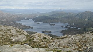
Kvernafjord is a small fjord next to Flatøy and just west of Knarvik in the municipalities of Lindås and Meland in Hordaland county, Norway. The fjord lies between Radfjord, which is part of the same fjord system, and the sound Hagelsund, which creates a link to the southeast, where Salhusfjord meets Osterfjord. Kvernafjord extends 3.5 kilometers (2.2 mi) northwest to a line between Radtangen on Radøy to the northeast and Skarpeneset on Holsnøy to the southwest. The strait Alverstraum lies to the east, creating a connection to Alversund. [2]

Fjord A long, narrow inlet with steep sides or cliffs, created by glacial activity

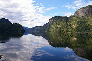
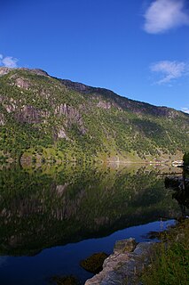
Geologically, a fjord or fiord is a long, narrow inlet with steep sides or cliffs, created by a glacier. There are many fjords on the coasts of Alaska, Antarctica, British Columbia, Chile, Greenland, the Faroe Islands, Iceland, Kamchatka, the Kerguelen Islands, New Zealand, Norway, Novaya Zemlya, Labrador, Nunavut, Newfoundland, Quebec, Scotland, South Georgia Island, and Washington state. Norway's coastline is estimated at 29,000 kilometres (18,000 mi) with nearly 1,200 fjords, but only 2,500 kilometres (1,600 mi) when fjords are excluded.

Flatøy island

Flatøy is an island in the municipality of Meland in Hordaland county, Norway. The 2.2-square-kilometre (0.85 sq mi) island is one of the two main islands that make up the municipality of Meland. The island lies in the district of Nordhordland, just north of the city of Bergen. The main village on the island is Krossneset on the southern part of the island. The northern part of the island, on the southwest shore of Kvernafjord, is very sparsely inhabited.

Knarvik Village in Western Norway, Norway

Knarvik is the administrative centre of the municipality of Lindås in Hordaland county, Norway. The 3.18 km2 (790-acre) village has a population (2013) of 5207, giving the village a population density of 1,637/km2 (4,240/sq mi). This makes it the largest settlement in the whole Nordhordland district of Hordaland. The village is located on the mainland, about 20 km (12 mi) straight north of the city at the confluence of four fjords: Osterfjorden, Sørfjorden, Salhusfjorden, and the Radfjorden. The village of Isdalstø lies immediately north of Knarvik.

At the south end of the fjord, European route E39 crosses the Hagelsund over the 623-meter (2,044 ft) Hagelsund Bridge. [3]

European route E39 highway in Norway and Denmark

E 39 is the designation of a 1330 km long north-south road in Norway and Denmark, running from Klett just south of Trondheim to Aalborg, via Orkanger, Vinjeøra, Halsa ... Straumsnes, Krifast, Batnfjordsøra, Molde ... Vestnes, Skodje, Ålesund ... Volda ... Nordfjordeid ... Sandane, Førde, Lavik ... Instefjord, Knarvik, Bergen, Os ... Stord, Sveio, Aksdal, Bokn ... Rennesøy, Randaberg, Stavanger, Sandnes, Ålgård, Helleland, Flekkefjord, Lyngdal, Mandal, Kristiansand ... Hirtshals, Hjørring, and Nørresundby. Several sections are via ferry, denoted by ... in the above list. In total there are nine ferries, the highest number of ferries for a single road in Europe.

Hagelsund Bridge

The Hagelsund Bridge is a suspension bridge in Hordaland county, Norway. The bridge connects the island of Flatøy with the village of Knarvik on the mainland. The length of the bridge is 623 metres (2,044 ft) with the largest of the 9 spans being 250 metres (820 ft) wide. The bridge consists of 2 lanes with car traffic heading in opposite directions, and a walkway for pedestrians and bicycles. The bridge has a 50-metre (160 ft) clearance above the ocean for boats to pass beneath the bridge.

Related Research Articles

Masfjorden Municipality in Hordaland, Norway

Masfjorden is a municipality in the northern part of Hordaland county in Norway. The municipality is located in the Nordhordland district of the county. The administrative centre of the municipality is the village of Masfjordnes. Other villages in the municipality include Frøyset, Hosteland, Matre, and Solheim.

Vigdarvatnet is a lake in the municipality of Sveio in Hordaland county, Norway. A small arm off the main lake juts to the south and runs along the municipal-county border between Sveio in Hordaland county and the town of Haugesund in Rogaland county. The 10-kilometre (6.2 mi) long lake forms a U-shape. It is fed by the nearby lake Stakkastadvatnet to the south, and it empties into the Ålfjorden, a small fjord arm off the main Hardangerfjorden. The village of Sveio lies on the northwestern shore of the lake.

Krossneset Village in Western Norway, Norway

Krossneset is a village in Meland municipality, in Hordaland county, Norway. The village sits on the island of Flatøy, about half-way between the villages of Frekhaug and Knarvik. The 0.59-square-kilometre (150-acre) village has a population (2013) of 514, giving the village a population density of 871 inhabitants per square kilometre (2,260/sq mi).

Holsnøy island in Norway

Holsnøy is an island in Meland municipality, Hordaland county, Norway. The 88.8-square-kilometre (34.3 sq mi) island is the largest island in the municipality, and it makes up 98% of the land area of Meland municipality. The highest point on the island is the 324-metre (1,063 ft) tall Eldsfjellet, a mountain located about 2 kilometres (1.2 mi) north of the village of Rossland. The island is hilly and marshy, with the majority of the residents living along the southern shore. The largest settlement on the island is the village of Frekhaug on the southern shore. The island lies to the north/west of the mainland, between the islands of Radøy to the north and Askøy to the south.

Osterfjorden fjord in Hordaland, Norway

Osterfjorden is a fjord in Hordaland county, Norway. The fjord is one of three fjords surrounding the island of Osterøy. The fjord runs along the municipal border of Lindås and Osterøy municipalities. The fjord begins at the Romarheimsfjorden and flows to the west for 27 kilometres (17 mi) before ending near the village of Knarvik at the confluence of four fjords: Osterfjorden, Radfjorden, Sørfjorden, and Salhusfjorden. The Osterfjorden is generally about 1 to 3 kilometres wide and the deepest point in the fjord reaches a depth of 639 metres (2,096 ft) below sea level.

Austfjorden (Hordaland) fjord in Hordaland, Norway

Austfjorden is a fjord in Hordaland county, Norway. The 20-kilometre (12 mi) long fjord runs along the border between the municipalities of Lindås and Masfjorden. It starts in Lindås and extends to the northwest. The Masfjorden joins the Austfjorden from the north, and then the Austfjorden empties into the Fensfjorden before reaching the open sea near Fedje. The Austfjorden is the innermost arm of the Fensfjorden. The village of Knarrviki and the Mongstad industrial area lie on the western shore of the Austfjorden. The village of Myking lies on the western shore of the fjord, near the innermost part of the fjord.

Fensfjorden

Fensfjorden is a fjord on the border of Hordaland and Sogn og Fjordane counties in Norway. The 30-kilometre (19 mi) long fjord begins in the North Sea at Holmengrå Lighthouse and flows to the southeast through the municipalities of Austrheim, Gulen, Lindås, and Masfjorden. The fjord ends on the Masfjorden-Lindås border where it splits into two fjords: Masfjorden and Austfjorden.

Romarheimsfjorden

Romarheimsfjorden is a fjord in Hordaland county, Norway. The fjord flows through the municipalities of Modalen, Lindås, and Osterøy. The western end of the fjord lies near the island of Hokøy where the fjord flows in to the Osterfjorden on its way out to sea. The fjord extends eastward from Hokøy for 11 kilometres (6.8 mi) along the border of Lindås and Osterøy before entering Modalen where it continues to the Mostraumen, a 60-metre (200 ft) wide channel that is 650 metres (2,130 ft) long. On the other side of the channel, the fjord continues for another 18 kilometres (11 mi) where it is usually called the Mofjorden. That fjord ends at the village of Mo.

Radfjorden

Radfjorden is a fjord in Hordaland county, Norway. The 10-kilometre (6.2 mi) long fjord runs between the islands of Radøy and Holsnøy. The northwestern end of the fjord is called the Mangerfjorden and it flows out into the Hjeltefjorden. The southeastern end of the fjord is also known as Kvernafjord, and it flows out into the confluence of three other fjords: Salhusfjorden, Osterfjorden, and Sørfjorden. The fjord is a good fishing area, and it is also good for catching crab and shrimp.

Granvin Fjord

The Granvin Fjord is an arm of the Hardanger Fjord in the municipalities of Granvin and Ullensvang in Hordaland county, Norway. The fjord is about 10 kilometers (6.2 mi) long and its width is mostly less than 1 kilometer (0.62 mi). It has its inlet at the part of the Hardanger Fjord known as the Inner Samla Fjord between two small peninsulas: Furenes by the village of Tjoflot on the east side and Håstabbenes on the west side. From there, the fjord runs in a northeast direction to the village of Granvin at the head of the fjord. The fjord has steep sides and is bordered by mountains up to 1,200 meters (3,900 ft) high.

Eid Fjord fjord in Hordaland, Norway

The Eid Fjord is the innermost part of the Hardanger Fjord in Norway. It extends 29 kilometers (18 mi) eastwards from the Utne Fjord and Sørfjorden. The Eid Fjord lies in the municipalities of Ullensvang, Ulvik, and Eidfjord in Hordaland county.

Brimnes Village in Western Norway, Norway

Brimnes is a small village in the municipality of Eidfjord in Hordaland county, Norway.

Simadal Fjord

The Simadal Fjord is a branch of the Eid Fjord in the municipality of Eidfjord in Hordaland, Norway. The Simadal Fjord is the innermost branch of the Hardanger Fjord. It is 5 kilometers (3.1 mi) long and extends east from its mouth between Blurnes and Eikenes to the head of the fjord at the Sima Valley.

Sima Valley

The Sima Valley is a river valley in the municipality of Eidfjord in Hordaland county, Norway. The 8-kilometre (5.0 mi) long valley begins below Lake Rembesdal, with an elevation of 905 meters (2,969 ft), which is one of the sources of the Sima River. The valley then runs west along the river to the Sima Hydroelectric Power Station at the head of the Simadal Fjord, where the river empties into the fjord. Norwegian County Road 103 runs through part of the valley and then continues along the south side of the fjord.

The Kvernhushaug Tunnel is a 542-meter (1,778 ft) tunnel along Norwegian National Road 7 in the municipality of Eidfjord in Hordaland, Norway.

Ringøy Village in Western Norway, Norway

Ringøy is a small village in the municipality of Eidfjord in Hordaland county, Norway.

Norwegian County Road 550

County Road 550 is an 81.96-kilometer (50.93 mi) road in Norway. The road runs from Jondal in the municipality of Jondal to Odda in the municipality of Odda.

References