Kyuquot (disambiguation)

Last updated

Kyuquot, pronounced "ky YOO cut", meaning "people of Kayukw" in the Nuu-chah-nulth language, may refer to:

Nuu-chah-nulth (nuučaan̓uɫ), also known as Nootka, is a Wakashan language spoken in the Pacific Northwest of North America on the west coast of Vancouver Island, from Barkley Sound to Quatsino Sound in British Columbia by the Nuu-chah-nulth peoples. Nuu-chah-nulth is a Southern Wakashan language related to Nitinaht and Makah.

Kyuquot Place in British Columbia, Canada

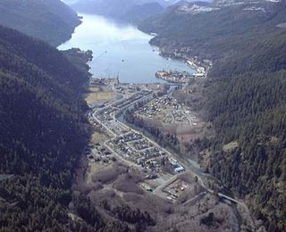
Kyuquot is an unincorporated settlement and First Nations Indian reserve community located on Kyuquot Sound on northwestern Vancouver Island, British Columbia, Canada. Meaning people of Kayukw in the Nuu-chah-nulth language, it is partly the community of the Kyuquot and Cheklesahht peoples, whose band government is the Kyuquot/Cheklesahht First Nation. The site of Kayukw, the original village of the Kyuquot people, is nearby in the form of Kayouk Indian Reserve No. 8, adjacent to which are Kayouk Bluff and Kayouk Creek. The original village site of the Cheklesahht people is the Checkaklis Island Indian Reserve 9 on the island of the same name in the Bunsby Islands in Checleset Bay, which is named for the people, whose name means "people of Checkaklis".

Kyuquot Sound is a complex of coastal inlets, bays and islands on northwestern Vancouver Island in the Canadian province of British Columbia.

The Kyuquot/Cheklesath First Nation is a First Nations government based at Kyuquot, located on the outer coast of Kyuquot Sound, on the west coast of Vancouver Island in British Columbia, Canada. It is a member of the Nuu-chah-nulth Tribal Council.

Related Research Articles

Sound (geography) A long, relatively wide body of water, connecting two larger bodies of water

In geography, a sound is a large sea or ocean inlet, deeper than a bight and wider than a fjord; or a narrow sea or ocean channel between two bodies of land.

Nootka Island island

Nootka Island is an island adjacent to Vancouver Island in British Columbia, Canada. It is 534 square kilometres (206 sq mi) in area. It is separated from Vancouver Island by Nootka Sound and its side-inlets, and is located within Electoral Area A of the Strathcona Regional District.

Ucluelet District municipality in British Columbia, Canada

Ucluelet is a district municipality on the Ucluelet Peninsula on the west coast of Vancouver Island in British Columbia, Canada. Ucluelet means "people of the safe harbour" in the indigenous Nuu-chah-nulth (Nootka) language.

Tahsis Village in British Columbia, Canada

Tahsis is a village municipality on the west coast of Vancouver Island, British Columbia, Canada, about 300 km or 185 miles northwest of the provincial capital Victoria at 49°55′33″N 126°37′16″W. As of 2011, the Canadian census listed 316 residents, a decline from the 2006 Census count of 366 residents. The Village of Tahsis economy used to be dependent on forestry, but after the closure of the local sawmill in 2001, the economy became heavily dependent on sport fishing for salmon and halibut, outdoor recreation and tourism.

Kyuquot Water Aerodrome airport in British Columbia, Canada

Kyuquot Water Aerodrome,, is located adjacent to Kyuquot, British Columbia, Canada.

Brooks Peninsula Provincial Park provincial park

Parts of this article have been adapted from the BC Parks website.

Catala Island Marine Provincial Park is a provincial park in British Columbia, Canada, located on the west coast of Vancouver Island at the mouth of Esperanza Inlet, between Kyuquot Sound (N) and Nootka Sound (S). The park is 850 ha. in size and was established in July 1995.

Dixie Cove Marine Provincial Park, originally Dixie Cove Provincial Park, is a provincial park in British Columbia, Canada, located on the east side of Hohoae Island, which is just west of Fair Harbour in Kyuquot Sound on the West Coast of Vancouver Island.

Rugged Point Marine Provincial Park is a provincial park in British Columbia, Canada, located at the southeast entrance to Kyuquot Sound on the west coast of Vancouver Island.

Zeballos, British Columbia Village in British Columbia, Canada

Zeballos is a village located on the northwest coast of Vancouver Island in British Columbia, Canada. While legend suggests Spanish gold seekers may have explored the area in the late 16th century, Zeballos is now known for its ecotourism and sport fishing.

School District 84 Vancouver Island West is a school district in British Columbia. It covers the northwest corner of Vancouver Island. This includes the major centre of Gold River and the remote communities of Tahsis, Zeballos and Kyuquot.

Island Health organization

Island Health, also known as the Vancouver Island Health Authority, is the publicly funded health care provider in the southwestern portion of the Canadian province of British Columbia. The region includes the communities of:

The Strathcona Regional District is a regional district in British Columbia, Canada. It was created on February 15, 2008, encompassing the northern and western portions of the former Regional District of Comox-Strathcona. The partition left the new Strathcona Regional District with 91.6 percent of the former Comox-Strathcona's land area, but only 42.1 percent of its population. Its current territory has a land area of 18,329.948 km² and a 2016 census population of 44,671 inhabitants. There are 21 named Indian reserves within its territory, with a combined 2016 census population of 1,579 and combined land area of 16.444 km².

Quatsino Sound is a complex of coastal inlets, bays and islands on northwestern Vancouver Island in the Canadian province of British Columbia. It is the northernmost of the five sounds that pierce the west coast of Vancouver Island, the others being Kyuquot Sound, Nootka Sound, Clayoquot Sound, and Barclay Sound.