LaGrange County | |
---|---|
Coordinates: 41°38′30″N85°25′00″W / 41.6417°N 85.4167°W | |
Country | United States |
State | Indiana |
Founded | 1832 |
Named for | Château de la Grange-Bléneau |
Seat | LaGrange |
Largest city | LaGrange |
Area | |
• Total | 386.70 sq mi (1,001.5 km2) |
• Land | 379.62 sq mi (983.2 km2) |
• Water | 7.08 sq mi (18.3 km2) 1.83% |
Population (2020) | |
• Total | 40,446 |
• Estimate (2022) [1] | 40,866 |
• Density | 100/sq mi (40/km2) |
Time zone | UTC−5 (Eastern) |
• Summer (DST) | UTC−4 (EDT) |
Congressional district | 3rd |
Website | www |
Indiana county number 44 |
LaGrange County is a county located in the U.S. state of Indiana. As of 2020, the population was 40,446. [2] The county seat is LaGrange, Indiana. [3]
The county is located in the Northern Indiana region known as Michiana and is about 55 miles (89 km) east of South Bend, 105 miles (169 km) west of Toledo, Ohio, and 175 miles (282 km) northeast of Indianapolis. The area is well known for its large Amish population. [4] For that reason, the county teams up with neighboring Elkhart County to promote tourism by referring to the area as Northern Indiana Amish Country. [5]
About half of LaGrange County is Amish, [2] and it is home to the third-largest Amish community in the United States, which belongs to the Elkhart-LaGrange Amish affiliation.
The first settlement of LaGrange County was founded about a half mile west of Lima in 1828.[ citation needed ] Over the next four years, settlers flocked to parts of Lima, Springfield, and Van Buren Townships. Finally in 1832, LaGrange County was carved out of neighboring Elkhart County and established with Lima as the county seat. [6] The town of LaGrange was platted in 1836 and settled in 1842 as the new county seat, closer to the center of the county. [7] Lima's name was changed to Howe in 1909. [6] LaGrange was laid out and platted in 1836. [8]
LaGrange County's initial settlers were Yankee immigrants, that is to say, they were from New England. They were descended from the English Puritans who settled that region in the colonial era. They were part of a wave of New England settlers moving west into what was then the Northwest Territory after the completion of the Erie Canal. The original settlers in LaGrange County specifically hailed from the Massachusetts counties of Worcester County, Suffolk County and Berkshire County; the Connecticut counties of Hartford County and Windham County as well as the Connecticut towns of Sherman, Lebanon and Fairfield; and from the Vermont towns of Burlington, Brookfield, Huntington and Grand Isle. They were mainly members of the Congregational Church, but as a result of the Second Great Awakening, many became Baptists and many also converted to Pentecostalism and Methodism. When they arrived in LaGrange County, there was nothing but a virgin forest and wild prairie. The New England settlers cleared roads, built farms, constructed churches, erected government buildings, and established post routes. As a result of this migration, LaGrange County was culturally continuous with early New England culture for many years. [9]
In 1837, the government removed Chief Shipshewana and the Potawatomi Tribe from the county's northwest corner. Several years later, the Chief was allowed to return and died in Newbury Township in 1841. [6] A town named Georgetown had been platted in 1837 but was abandoned because of lack of development. In 1844, the first Amish came from Pennsylvania to settle around the old town. The village continued to grow, and the town of Shipshewana was platted nearby in 1899 and incorporated in 1916 in Newbury Township. [6]
LaGrange County was named after the Château de la Grange-Bléneau, home of Revolutionary War hero, the Marquis de la Fayette, outside of Paris, France. [10]
According to the 2010 census, the county has a total area of 386.70 square miles (1,001.5 km2), of which 379.62 square miles (983.2 km2) (or 98.17%) is land and 7.08 square miles (18.3 km2) (or 1.83%) is water. [11]
The county is mostly made up of rural farmland but also some rolling hills and several lakes.
LaGrange, Indiana | ||||||||||||||||||||||||||||||||||||||||||||||||||||||||||||
---|---|---|---|---|---|---|---|---|---|---|---|---|---|---|---|---|---|---|---|---|---|---|---|---|---|---|---|---|---|---|---|---|---|---|---|---|---|---|---|---|---|---|---|---|---|---|---|---|---|---|---|---|---|---|---|---|---|---|---|---|
Climate chart (explanation) | ||||||||||||||||||||||||||||||||||||||||||||||||||||||||||||
| ||||||||||||||||||||||||||||||||||||||||||||||||||||||||||||
|
In recent years, average temperatures in LaGrange have ranged from a low of 14 °F (−10 °C) in January to a high of 82 °F (28 °C) in July, although a record low of −28 °F (−33 °C) was recorded in December 2000 and a record high of 104 °F (40 °C) was recorded in June 1988. Average monthly precipitation ranged from 1.76 inches (45 mm) in February to 4.17 inches (106 mm) in June. [12]
Census | Pop. | Note | %± |
---|---|---|---|
1840 | 3,664 | — | |
1850 | 8,387 | 128.9% | |
1860 | 11,366 | 35.5% | |
1870 | 14,148 | 24.5% | |
1880 | 15,630 | 10.5% | |
1890 | 15,615 | −0.1% | |
1900 | 15,284 | −2.1% | |
1910 | 15,148 | −0.9% | |
1920 | 14,009 | −7.5% | |
1930 | 13,780 | −1.6% | |
1940 | 14,352 | 4.2% | |
1950 | 15,347 | 6.9% | |
1960 | 17,380 | 13.2% | |
1970 | 20,890 | 20.2% | |
1980 | 25,550 | 22.3% | |
1990 | 29,477 | 15.4% | |
2000 | 34,909 | 18.4% | |
2010 | 37,128 | 6.4% | |
2020 | 40,446 | 8.9% | |
2023 (est.) | 40,907 | [13] | 1.1% |
U.S. Decennial Census [14] 1790–1960 [15] 1900–1990 [16] 1990–2000 [17] 2010–2013 [18] 2020 [2] |
Race / Ethnicity | Pop. 2010 [19] | Pop. 2020 [20] | % 2010 | % 2020 |
---|---|---|---|---|
White alone (NH) | 35,290 | 37,834 | 95.05% | 93.54% |
Black or African American alone (NH) | 109 | 92 | 0.29% | 0.23% |
Asian alone (NH) | 118 | 74 | 0.32%% | 0.18% |
Native American or Alaska Native alone (NH) | 65 | 50 | 0.17% | 0.12% |
Pacific Islander alone (NH) | 1 | 1 | 0.00% | 0.00% |
Some Other Race alone (NH) | 8 | 33 | 0.02% | 0.08% |
Mixed Race/Multi-Racial (NH) | 220 | 629 | 0.59% | 1.55% |
Hispanic or Latino (any race) | 1,317 | 1,733 | 3.55% | 4.28% |
Total | 37,128 | 40,446 | 100.00% | 100.00% |
Note: the US Census treats Hispanic/Latino as an ethnic category. This table excludes Latinos from the racial categories and assigns them to a separate category. Hispanics/Latinos can be of any race.
As of the 2010 United States Census, there were 37,128 people, 11,598 households, and 9,106 families residing in the county. [21] The population density was 97.8 inhabitants per square mile (37.8/km2). There were 14,094 housing units at an average density of 37.1 per square mile (14.3/km2). [11] The racial makeup of the county was 96.6% white, 0.3% black or African American, 0.3% Asian, 0.2% American Indian, 1.7% from other races, and 0.8% from two or more races. Those of Hispanic or Latino origin made up 3.5% of the population. [21] In terms of ancestry, 36.1% were German, 13.3% were American, 6.4% were Irish, and 6.4% were English. [22]
Of the 11,598 households, 40.2% had children under the age of 18 living with them, 67.6% were married couples living together, 7.1% had a female householder with no husband present, 21.5% were non-families, and 18.4% of all households were made up of individuals. The average household size was 3.17, and the average family size was 3.66. The median age was 30.4 years. [21]
The median income for a household in the county was $47,697 and the median income for a family was $53,793. Males had a median income of $40,960 versus $29,193 for females. The per capita income for the county was $18,388. About 12.1% of families and 16.0% of the population were below the poverty line, including 23.5% of those under age 18 and 16.6% of those age 65 or over. [23]
Approximately 43% of the population of LaGrange County is Amish, as the county is home to the third-largest Amish community in the United States and belongs to the Elkhart-LaGrange Amish affiliation. This is reflected in the linguistic situation in the county: 28.45% of the population report speaking German, Pennsylvania German, or Dutch at home. [24] 68.5% of the total population and 61.29% of the children in 5-17 age group used English as their home language, according to 2000 Census. The Amish languages (German, Pennsylfaansch, and Dutch) were used by 28.47% of the total population and 35.77% of them. [25]
As of 2020 census, Terry Martin, president of the LaGrange County Commissioners, said that "the Amish-English ratio is about 50-50", also adding that the nearly 9% growth, or 3,318 people [between 2010 and 2020 censuses], was mainly due to the increasing Amish population. [2]
*"Nones" is an unclear category. [26] [27] It is a heterogenous group of the not religious and intermittently religious. [28] Researchers argue that most of the "Nones" should be considered "unchurched", rather than objectively nonreligious; [27] [29] [30] [31] especially since most "Nones" do hold some religious-spiritual beliefs and a notable amount participate in behaviors. [27] [29] [32] [33] For example, 72% of American "Nones" believe in God or a Higher Power. [34]
The economy is based mainly on agriculture and small shops, but tourism also plays a big role, especially in Shipshewana.
The county is led by a board of three elected commissioners that serve as the county government's executive branch. The county council comprises 7 elected members – four from each council district and 3 at large. Also, one assessor serves the entire county as opposed to one for every township.
The current county commissioners are: [35]
The current county council members are: [36]
LaGrange County is part of Indiana's 3rd congressional district; Indiana Senate district 13; [37] and Indiana House of Representatives districts 18 and 52. [38]
LaGrange County has consistently been a Republican Party stronghold in presidential elections. In only three elections since 1888 has a Republican candidate failed to win the county, most recently in 1964.
Year | Republican | Democratic | Third party | |||
---|---|---|---|---|---|---|
No. | % | No. | % | No. | % | |
2020 | 8,110 | 76.14% | 2,355 | 22.11% | 187 | 1.76% |
2016 | 7,025 | 72.68% | 2,080 | 21.52% | 561 | 5.80% |
2012 | 6,231 | 66.88% | 2,898 | 31.11% | 187 | 2.01% |
2008 | 5,702 | 59.80% | 3,663 | 38.42% | 170 | 1.78% |
2004 | 6,430 | 71.42% | 2,523 | 28.02% | 50 | 0.56% |
2000 | 5,437 | 65.25% | 2,733 | 32.80% | 163 | 1.96% |
1996 | 4,033 | 52.11% | 2,704 | 34.94% | 1,003 | 12.96% |
1992 | 3,584 | 48.15% | 2,093 | 28.12% | 1,767 | 23.74% |
1988 | 4,495 | 68.67% | 2,029 | 31.00% | 22 | 0.34% |
1984 | 4,772 | 71.31% | 1,884 | 28.15% | 36 | 0.54% |
1980 | 4,259 | 62.49% | 2,095 | 30.74% | 461 | 6.76% |
1976 | 3,876 | 57.24% | 2,835 | 41.86% | 61 | 0.90% |
1972 | 4,152 | 71.11% | 1,658 | 28.40% | 29 | 0.50% |
1968 | 3,328 | 61.54% | 1,691 | 31.27% | 389 | 7.19% |
1964 | 2,785 | 49.38% | 2,818 | 49.96% | 37 | 0.66% |
1960 | 4,433 | 69.03% | 1,965 | 30.60% | 24 | 0.37% |
1956 | 3,815 | 70.47% | 1,562 | 28.85% | 37 | 0.68% |
1952 | 3,822 | 68.80% | 1,604 | 28.87% | 129 | 2.32% |
1948 | 3,106 | 63.82% | 1,628 | 33.45% | 133 | 2.73% |
1944 | 3,501 | 68.71% | 1,539 | 30.21% | 55 | 1.08% |
1940 | 3,731 | 63.43% | 2,124 | 36.11% | 27 | 0.46% |
1936 | 3,125 | 51.72% | 2,821 | 46.69% | 96 | 1.59% |
1932 | 2,461 | 42.29% | 3,261 | 56.03% | 98 | 1.68% |
1928 | 3,171 | 64.40% | 1,720 | 34.93% | 33 | 0.67% |
1924 | 3,081 | 63.34% | 1,566 | 32.20% | 217 | 4.46% |
1920 | 3,852 | 68.02% | 1,687 | 29.79% | 124 | 2.19% |
1916 | 1,958 | 54.09% | 1,512 | 41.77% | 150 | 4.14% |
1912 | 758 | 21.58% | 1,233 | 35.11% | 1,521 | 43.31% |
1908 | 2,357 | 60.13% | 1,414 | 36.07% | 149 | 3.80% |
1904 | 2,461 | 64.61% | 1,100 | 28.88% | 248 | 6.51% |
1900 | 2,329 | 59.34% | 1,431 | 36.46% | 165 | 4.20% |
1896 | 2,442 | 58.97% | 1,665 | 40.21% | 34 | 0.82% |
1892 | 2,033 | 54.59% | 1,438 | 38.61% | 253 | 6.79% |
1888 | 2,262 | 57.32% | 1,516 | 38.42% | 168 | 4.26% |
The county has three public school districts.
The Lakeland Community Schools serve the central part of the county. The system includes Lakeland Primary: Grades (k-2), Lakeland Intermediate: grades (3-6), and Lakeland Jr/Sr High: grades (7-12).
The Prairie Heights School Corporation serves the east side of the county and parts of Steuben County. The mascot of Prairie Heights School is a black panther.
The Westview School Corporation serves the west portion of the county. This system consists of four elementary schools (Meadowview, Shipshewana-Scott, Topeka, and Westview) and one junior-senior high school named Westview.
Several Amish schools are located across the county.
LaGrange County is served by the La Grange County Public Library, with branches in LaGrange, Shipshewana, and Topeka. [40]
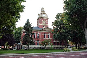
Goshen is a city in and the county seat of Elkhart County, Indiana, United States. It is the smaller of the two principal cities of the Elkhart–Goshen Metropolitan Statistical Area, which in turn is part of the South Bend–Elkhart–Mishawaka Combined Statistical Area. It is located in the northern part of Indiana near the Michigan border, in a region known as Michiana. Goshen is located 10 miles southeast of Elkhart, 25 miles southeast of South Bend, 120 miles east of Chicago, and 150 miles north of Indianapolis. The population was 34,517 at the 2020 census.
Adams County lies in northeastern Indiana in the United States and shares its eastern border with Ohio. It was officially established in 1836. The county seat is Decatur.
Holmes County is a county in the U.S. state of Ohio. As of the 2020 Census, the population was 44,223. Its county seat is Millersburg. The county was formed in 1824 from portions of Coshocton, Tuscarawas and Wayne counties and organized the following year. It was named after Andrew Holmes, an officer killed in the War of 1812.
St. Joseph County is a county located in the U.S. state of Michigan, on the central southern border with Indiana. As of the 2020 United States Census, the population was 60,939. The county seat is Centreville.
Cass County is a county in the U.S. state of Michigan. As of the 2020 Census, the population was 51,589. Its county seat is Cassopolis.
Hart County is a county located in the south central portion of the Commonwealth of Kentucky. As of the 2020 census, the population was 19,288. Its county seat is Munfordville, its largest city is Horse Cave. Hart County is a prohibition or dry county.
Noble County is a county in the U.S. state of Indiana. As of the 2020 United States Census, the population was 47,457. The county seat is Albion. The county is divided into 13 townships which provide local services.
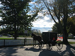
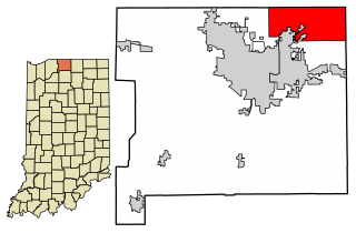
Elkhart County is a county located in the U.S. state of Indiana. As of 2020, the county's population was 207,047. The county seat is Goshen. Elkhart County is part of the Elkhart-Goshen Metropolitan Statistical Area, which in turn is part of the South Bend-Elkhart-Mishawaka Combined Statistical Area. It is also considered part of the broader region of Northern Indiana known as Michiana, and is 20 miles (32 km) east of South Bend, Indiana, 110 miles (180 km) east of Chicago, Illinois, and 150 miles (240 km) north of Indianapolis, Indiana. The area is referred to by locals as the recreation vehicle (RV) capital of the world and is known for its sizable Amish and Old Order Mennonite population.
Bristol is a town in Washington Township, Elkhart County, Indiana, United States. The population was 1,602 at the 2010 census.
Elkhart is a city in Elkhart County, Indiana, United States. The city is located 15 miles (24 km) east of South Bend, Indiana. Elkhart has the larger population of the two principal cities of the Elkhart-Goshen Metropolitan Statistical Area, which in turn is part of the South Bend-Elkhart-Mishawaka Combined Statistical Area, in a region commonly known as Michiana. The population was 53,923 at the 2020 census. Despite the shared name and being the most populous city in the county, it is not the county seat of Elkhart County; that position is held by the city of Goshen, located about 10 miles (16 km) southeast of Elkhart.
Middlebury is a town in Middlebury Township, Elkhart County, Indiana, United States. It is located approximately 35 miles east of South Bend, 130 miles east of Chicago, Illinois and 165 miles north of Indianapolis. Middlebury is nestled in Northern Indiana's Amish country. As of the 2010 census, the town population was 3,420.
Nappanee is a city in Elkhart and Kosciusko counties in the U.S. state of Indiana. The population was 6,648 as of the 2010 U.S. Census and had grown to 6,913 by the 2020 U.S. Census. The name Nappanee is thought to mean "flour" in the Algonquian language.
New Paris is a census-designated place (CDP) in Elkhart County, Indiana, United States. The population was 1,494 at the 2010 census.
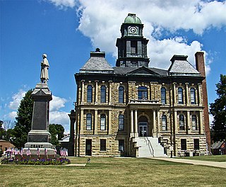
LaGrange is a town in and the county seat of LaGrange County, Indiana, United States. The population was 2,625 at the 2010 census.
Shipshewana is a town in Newbury Township, LaGrange County, Indiana, United States. The population was 658 at the 2010 census. It is the location of the Menno-Hof Amish & Mennonite Museum, which showcases the history of the Amish and Mennonite peoples.
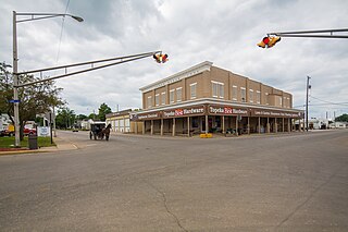
Topeka is a town in Clearspring and Eden townships, LaGrange County, Indiana, United States. The population was 1,153 at the 2010 census. Topeka is located approximately eleven miles south of Shipshewana, Indiana.
Wolcottville is a town in Orange Township, Noble County and Johnson Township, LaGrange County in the U.S. state of Indiana. The population was 998 at the 2010 census.
Granger is a census-designated place (CDP) in Clay and Harris townships, St. Joseph County, in the U.S. state of Indiana. The population was 30,465 at the 2010 census. Penn-Harris-Madison School Corporation and the South Bend Community School Corporation maintain the public schools in the area. Granger is part of the South Bend–Mishawaka metropolitan area as well as the larger Michiana region.
Elkhart is a city in Polk County, Iowa, United States. The population was 882 at the time of the 2020 census. It is part of the Des Moines–West Des Moines Metropolitan Statistical Area.
The South Bend–Mishawaka Metropolitan Statistical Area, sometimes referred to as Michiana, as defined by the United States Census Bureau, is an area consisting of two counties – one in northern Indiana and one in southwest Michigan (Cass), anchored by the cities of South Bend and Mishawaka in Indiana. As of the 2010 census, the MSA had a population of 319,224.