La Crosse County | |
---|---|
Coordinates: 43°55′N91°07′W / 43.91°N 91.11°W | |
Country | United States |
State | Wisconsin |
Founded | 1851 |
Seat | La Crosse |
Largest city | La Crosse |
Area | |
• Total | 480 sq mi (1,200 km2) |
• Land | 452 sq mi (1,170 km2) |
• Water | 28 sq mi (70 km2) 5.9% |
Population (2020) | |
• Total | 120,784 |
• Estimate (2022) | 120,294 |
• Density | 250/sq mi (97/km2) |
Time zone | UTC−6 (Central) |
• Summer (DST) | UTC−5 (CDT) |
Congressional district | 3rd |
Website | www |
La Crosse County is a county located in the U.S. state of Wisconsin. At the 2020 census, the population was 120,784. [1] Its county seat is La Crosse. [2] La Crosse County is included in the La Crosse-Onalaska, WI-MN Metropolitan Statistical Area with a population of 139,627 and is the most populous county on Wisconsin's western border.
According to the U.S. Census Bureau, the county has a total area of 480 square miles (1,200 km2), of which 452 square miles (1,170 km2) is land and 28 square miles (73 km2) (5.9%) is water. [3]
La Crosse County's location in the United States' upper midwest gives the area a temperate, continental climate. [4] The warmest month of the year is July, when the average high temperature is 85.4 °F (29.7 °C), with overnight low temperatures averaging 27.4 °F (−2.6 °C). January is the coldest month, with high temperatures averaging 25.9 °F (−3.4 °C), with the overnight low temperatures around 10.5 °F (−11.9 °C). [5]
Climate data for La Crosse Regional Airport, Wisconsin (1981–2010 normals, [6] extremes 1872–present) | |||||||||||||
---|---|---|---|---|---|---|---|---|---|---|---|---|---|
Month | Jan | Feb | Mar | Apr | May | Jun | Jul | Aug | Sep | Oct | Nov | Dec | Year |
Record high °F (°C) | 57 (14) | 65 (18) | 84 (29) | 93 (34) | 107 (42) | 102 (39) | 108 (42) | 105 (41) | 101 (38) | 93 (34) | 80 (27) | 67 (19) | 108 (42) |
Mean maximum °F (°C) | 45.4 (7.4) | 50.5 (10.3) | 69.0 (20.6) | 82.2 (27.9) | 87.8 (31.0) | 93.6 (34.2) | 95.7 (35.4) | 94.0 (34.4) | 89.2 (31.8) | 80.6 (27.0) | 64.0 (17.8) | 48.1 (8.9) | 97.7 (36.5) |
Mean daily maximum °F (°C) | 25.9 (−3.4) | 31.4 (−0.3) | 43.9 (6.6) | 59.3 (15.2) | 70.7 (21.5) | 80.0 (26.7) | 84.1 (28.9) | 81.5 (27.5) | 73.2 (22.9) | 59.9 (15.5) | 43.8 (6.6) | 29.1 (−1.6) | 57.0 (13.9) |
Mean daily minimum °F (°C) | 8.9 (−12.8) | 13.6 (−10.2) | 25.2 (−3.8) | 37.9 (3.3) | 48.7 (9.3) | 58.5 (14.7) | 63.2 (17.3) | 61.3 (16.3) | 52.4 (11.3) | 40.4 (4.7) | 28.1 (−2.2) | 14.2 (−9.9) | 37.8 (3.2) |
Mean minimum °F (°C) | −13.8 (−25.4) | −10.4 (−23.6) | 3.9 (−15.6) | 21.7 (−5.7) | 34.1 (1.2) | 44.6 (7.0) | 51.5 (10.8) | 49.3 (9.6) | 36.5 (2.5) | 25.4 (−3.7) | 12.0 (−11.1) | −8.7 (−22.6) | −18.4 (−28.0) |
Record low °F (°C) | −43 (−42) | −36 (−38) | −28 (−33) | 7 (−14) | 26 (−3) | 33 (1) | 44 (7) | 35 (2) | 24 (−4) | 6 (−14) | −21 (−29) | −37 (−38) | −43 (−42) |
Average precipitation inches (mm) | 1.12 (28) | 1.05 (27) | 2.04 (52) | 3.34 (85) | 3.52 (89) | 4.34 (110) | 4.26 (108) | 4.29 (109) | 3.56 (90) | 2.17 (55) | 2.01 (51) | 1.36 (35) | 33.06 (840) |
Average snowfall inches (cm) | 10.7 (27) | 8.2 (21) | 7.1 (18) | 1.7 (4.3) | 0 (0) | 0 (0) | 0 (0) | 0 (0) | 0 (0) | 0.2 (0.51) | 4.1 (10) | 11.3 (29) | 43.3 (110) |
Average precipitation days (≥ 0.01 in) | 9.1 | 8.0 | 9.8 | 11.2 | 11.9 | 11.5 | 10.4 | 9.8 | 9.6 | 9.3 | 9.0 | 9.2 | 118.8 |
Average snowy days (≥ 0.1 in) | 7.8 | 6.4 | 4.3 | 1.2 | 0 | 0 | 0 | 0 | 0 | 0.3 | 3.1 | 7.0 | 30.1 |
Source: NOAA [7] [8] |
Census | Pop. | Note | %± |
---|---|---|---|
1860 | 12,186 | — | |
1870 | 20,297 | 66.6% | |
1880 | 27,073 | 33.4% | |
1890 | 38,801 | 43.3% | |
1900 | 42,997 | 10.8% | |
1910 | 43,996 | 2.3% | |
1920 | 44,355 | 0.8% | |
1930 | 54,455 | 22.8% | |
1940 | 59,653 | 9.5% | |
1950 | 67,587 | 13.3% | |
1960 | 72,465 | 7.2% | |
1970 | 80,468 | 11.0% | |
1980 | 91,056 | 13.2% | |
1990 | 97,904 | 7.5% | |
2000 | 107,120 | 9.4% | |
2010 | 114,638 | 7.0% | |
2020 | 120,784 | 5.4% | |
2022 (est.) | 120,294 | [9] | −0.4% |
U.S. Decennial Census [10] 1790–1960 [11] 1900–1990 [12] 1990–2000 [13] 2010–2020 [14] [15] |
As of the census of 2020, [16] the population was 120,784. The population density was 267.3 people per square mile (103.2 people/km2). There were 52,774 housing units at an average density of 116.8 units per square mile (45.1 units/km2). The racial makeup of the county was 88.0% White, 4.6% Asian, 1.7% Black or African American, 0.4% Native American, 0.9% from other races, and 4.4% from two or more races. Ethnically, the population was 2.5% Hispanic or Latino of any race.
According to 2014–2018 ACS estimates, the median household income was $55,479 and the median family income was $67,388. Males had a median income of $48,675 and females $38,714. The per capita income was $26,065. About 9.1% of families and 10.9% of the population were below the poverty line, including 8.2% of those under age 18 and 7.3% of those age 65 or over. [17]
At the 2010 census, [18] there were 114,638 people, 46,137 households and 27,373 families residing in the county. The population density was 255 per square mile (98/km2). There were 46,137 housing units at an average density of 96 per square mile (37/km2). The racial make up was 92.1% White, 1.4% Black or African American, 0.4% Native American, 4.1% Asian, 0.00% Pacific Islander, 0.3% from other races, and 1.6% from two or more races. 0.92% of the population were Hispanic or Latino of any race. 38.9% were of German, 20.3% Norwegian and 7.9% Irish ancestry. In 2017, there were 1,188 births, giving a general fertility rate of 47.9 births per 1000 women aged 15–44, the fifth lowest rate out of all 72 Wisconsin counties. [19]
La Crosse County has voted for the Democratic nominee in every presidential election since 1988. [24] The Milwaukee Journal Sentinel ranked La Crosse County as one of Wisconsin's most Democratic counties. [25] As a result of the 2020 presidential election, La Crosse County continued its Democratic trend by about 4% with a 13% lead over Republicans. [26] In the 2022 United States elections Democrats won every contested race in La Crosse County and flipped the Sheriff's race for the first time in recent history. [27]
La Crosse County is within the Wisconsin State Senate district 32, represented by Brad Pfaff (D). It also contains Wisconsin State Assembly districts 95 Jill Billings (D) and 94 Steve Doyle (D). Democrats also hold a majority of seats on the La Crosse County Board of Supervisors.
Year | Republican | Democratic | Third party | |||
---|---|---|---|---|---|---|
No. | % | No. | % | No. | % | |
2020 | 28,684 | 42.25% | 37,846 | 55.75% | 1,354 | 1.99% |
2016 | 26,378 | 41.43% | 32,406 | 50.89% | 4,890 | 7.68% |
2012 | 25,751 | 40.58% | 36,693 | 57.82% | 1,018 | 1.60% |
2008 | 23,701 | 37.49% | 38,524 | 60.94% | 993 | 1.57% |
2004 | 28,289 | 45.53% | 33,170 | 53.38% | 677 | 1.09% |
2000 | 24,327 | 43.79% | 28,455 | 51.22% | 2,777 | 5.00% |
1996 | 16,482 | 35.83% | 23,647 | 51.41% | 5,872 | 12.76% |
1992 | 18,891 | 36.14% | 22,838 | 43.69% | 10,544 | 20.17% |
1988 | 21,548 | 48.90% | 22,204 | 50.39% | 314 | 0.71% |
1984 | 25,721 | 58.77% | 17,787 | 40.64% | 261 | 0.60% |
1980 | 23,427 | 51.73% | 17,304 | 38.21% | 4,554 | 10.06% |
1976 | 24,188 | 58.06% | 16,674 | 40.02% | 797 | 1.91% |
1972 | 21,992 | 63.29% | 12,152 | 34.97% | 602 | 1.73% |
1968 | 17,433 | 55.76% | 11,570 | 37.00% | 2,264 | 7.24% |
1964 | 13,135 | 44.07% | 16,625 | 55.78% | 43 | 0.14% |
1960 | 18,319 | 56.08% | 14,310 | 43.81% | 36 | 0.11% |
1956 | 18,264 | 61.66% | 11,258 | 38.01% | 100 | 0.34% |
1952 | 19,271 | 61.90% | 11,808 | 37.93% | 53 | 0.17% |
1948 | 10,525 | 45.25% | 12,345 | 53.07% | 390 | 1.68% |
1944 | 12,784 | 50.93% | 12,247 | 48.79% | 72 | 0.29% |
1940 | 13,711 | 50.92% | 13,079 | 48.58% | 134 | 0.50% |
1936 | 7,558 | 33.09% | 14,455 | 63.29% | 827 | 3.62% |
1932 | 7,686 | 36.94% | 12,919 | 62.10% | 200 | 0.96% |
1928 | 11,321 | 55.78% | 8,877 | 43.74% | 97 | 0.48% |
1924 | 5,733 | 32.49% | 1,252 | 7.09% | 10,662 | 60.42% |
1920 | 10,067 | 73.96% | 2,588 | 19.01% | 956 | 7.02% |
1916 | 3,597 | 44.37% | 4,123 | 50.86% | 386 | 4.76% |
1912 | 2,272 | 28.28% | 4,263 | 53.07% | 1,498 | 18.65% |
1908 | 4,382 | 50.15% | 4,054 | 46.40% | 301 | 3.45% |
1904 | 5,506 | 61.76% | 3,089 | 34.65% | 320 | 3.59% |
1900 | 5,324 | 58.24% | 3,609 | 39.48% | 208 | 2.28% |
1896 | 6,297 | 64.58% | 3,058 | 31.36% | 396 | 4.06% |
1892 | 3,693 | 42.88% | 3,810 | 44.24% | 1,110 | 12.89% |
Washburn County is a county in the U.S. state of Wisconsin. It is named after Governor Cadwallader C. Washburn. As of the 2020 census, the population was 16,623. Its county seat is Shell Lake. The county was created in 1883.
Vernon County is a county in the U.S. state of Wisconsin. As of the 2020 census, the population was 30,714. Its county seat is Viroqua.
Rock County is a county in the U.S. state of Wisconsin. As of the 2020 census, the population was 163,687. Its county seat is Janesville. Rock County comprises the Janesville-Beloit, WI Metropolitan Statistical Area and is included in the Madison-Janesville-Beloit, WI Combined Statistical Area.
Monroe County is a county in the U.S. state of Wisconsin. As of the 2020 census, the population was 46,274. Its county seat is Sparta.
Marathon County is a county located in the U.S. state of Wisconsin. As of the 2020 census, the population was 138,013. Marathon County's seat is Wausau. It was founded in 1850, created from a portion of Portage County. At that time the county stretched to the northern border with the upper Michigan peninsula. It is named after the battlefield at Marathon, Greece.
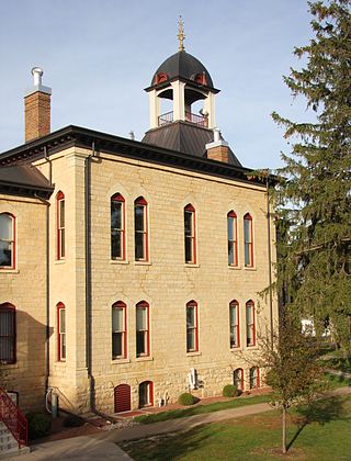
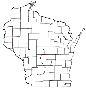
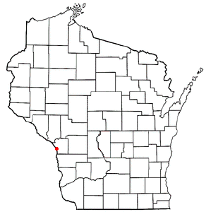
Lafayette County, sometimes spelled La Fayette County, is a county located in the U.S. state of Wisconsin. It was part of the Wisconsin Territory at the time of its founding. As of the 2020 census, the population was 16,611. Its county seat is Darlington. The county was named in honor of the Marquis de Lafayette, the French general who rendered assistance to the Continental Army in the American Revolutionary War. The courthouse scenes from the 2009 film Public Enemies were filmed at the Lafayette County Courthouse in Darlington.
Grant County is the most southwestern county in the U.S. state of Wisconsin. As of the 2020 census, the population was 51,938. Its county seat is Lancaster and its largest city is Platteville. The county is named after the Grant River, in turn named after a fur trader who lived in the area when Wisconsin was a territory. Grant County comprises the Platteville Micropolitan Statistical Area. It is in the tri-state area of Wisconsin, Illinois, and Iowa, and is crossed by travelers commuting to Madison, Wisconsin, from a number of eastern Iowan cities, and by residents of northern Illinois traveling to the Twin Cities or La Crosse, Wisconsin.
Eau Claire County is a county located in the U.S. state of Wisconsin. As of the 2020 census, the population was 105,710. Its county seat is Eau Claire. The county took its name from the Eau Claire River.
Dodge County is a county located in the U.S. state of Wisconsin. As of the 2020 census, the population was 89,396. Its county seat is Juneau. The county was created from the Wisconsin Territory in 1836 and organized in 1844.
Columbia County is a county located in the U.S. state of Wisconsin. As of the 2020 census, the population was 58,490. Its county seat and largest city is Portage. The county was created in 1846 as part of Wisconsin Territory.
Houston County is a county in the U.S. state of Minnesota. At the 2020 census, the population was 18,843. Its county seat is Caledonia.
Dakota is a city in Winona County, Minnesota, United States. The population was 295 at the 2020 census.
Brice Prairie is a census-designated place (CDP) in La Crosse County, Wisconsin, United States. The population was 1,887 at the 2010 census. Brice Prairie is located in the Town of Onalaska.
Campbell is a town in the middle of the Mississippi River in La Crosse County, Wisconsin, United States. It is part of the La Crosse, Wisconsin Metropolitan Statistical Area. The population was 4,284 as of the 2020 Census.
French Island is a census-designated place (CDP) in La Crosse County, Wisconsin, United States. The population was 4,207 at the 2010 census. It lies on an island of the same name, though they are not coextensive; a portion of the island is part of the city of La Crosse. All of the island is part of the La Crosse Metropolitan Statistical Area. French Island is part of the town of Campbell and contains all of its population, because the balance of Campbell is uninhabited.
La Crosse is a city in the U.S. state of Wisconsin and the county seat of La Crosse County. Positioned alongside the Mississippi River, La Crosse is the largest city on Wisconsin's western border. La Crosse's population as of the 2020 census was 52,680. The city forms the core of and is the principal city in the La Crosse–Onalaska Metropolitan Area, which includes all of La Crosse County and Houston County, Minnesota, with a population of 139,627.
West Salem is a village in La Crosse County, Wisconsin, United States, along the La Crosse River. It is part of the La Crosse-Onalaska, WI-MN Metropolitan Statistical Area. The population was 5,277 as of the 2020 census.
Onalaska is a town in La Crosse County, Wisconsin, United States. The population was 5,623 at the 2010 census. The City of Onalaska borders the town, as does the village of Holmen. The CDP of Brice Prairie is located in the western part of the Town of Onalaska. The unincorporated community of Midway is also located in the town. Onalaska (town), Wisconsin is part of the La Crosse, Wisconsin Metropolitan Statistical Area.
Onalaska is a city in La Crosse County, Wisconsin, United States. The population was 18,803 at the 2020 census. It borders the larger La Crosse, Wisconsin, and is a part of the La Crosse-Onalaska, WI-MN Metropolitan Area.
Sparta is a city in and the county seat of Monroe County, Wisconsin, United States, along the La Crosse River. The population was 10,025 at the 2020 census.