L'Alpe d'Huez is a ski resort in southeastern France at 1,250 to 3,330 metres. It is a mountain pasture in the Central French Western Alps, in the commune of Huez, which is part of the department of Isère in the region of Auvergne-Rhône-Alpes.

Val d'Isère is a commune of the Tarentaise Valley, in the Savoie department in southeastern France. It lies 5 km (3 mi) from the border with Italy. It is on the border of the Vanoise National Park created in 1963. During the Albertville 1992 Winter Olympics, the Face de Bellevarde was the site of the men's downhill race. Other alpine skiing events held during those games included men's giant slalom and alpine combined. Val d'Isère regularly hosts World Cup alpine events, usually for the men in early December, and hosted the World Championships in 2009. It is located in the Savoie région with good transport links in and out of Lyon, Geneva and Chambéry. The ski area of Val d'Isère and Tignes forms the Espace Killy, named after the triple Olympic champion Jean-Claude Killy who grew up in Val d'Isère. There are two mountain huts owned by the Vanoise National Park on the territory of Val d’Isère: le Refuge du Prariond and le Refuge du Fond des Fours.

La Plagne is a French ski area in the alpine valley of the Tarentaise (Savoie). Since 2003, La Plagne and the neighbouring resort of Les Arcs from Paradiski's ski area. It is currently owned by Compagnie des Alpes.

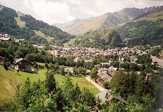
Méribel is a ski resort in the Tarentaise Valley in the French Alps. Méribel refers to three neighbouring villages in the Les Allues commune of the Savoie department of France, near the town of Moûtiers, called Méribel Centre, Méribel-Mottaret and Méribel Village. The villages are within Vanoise National Park and a part of the Les Trois Vallées interlinked ski system.

Les Houches is a commune in the Haute-Savoie department in the Auvergne-Rhône-Alpes region of Eastern France. In 2017, it had a population of 2,943.
Tignes is a commune in the Tarentaise Valley, in the Savoie department in the Rhône-Alpes region in south-eastern France, known for the highest skiable area in Europe and the longest ski season in Europe. It is located in the Savoie region with good transport links in and out of Lyon, Geneva and Chambery.

Verbier is a village located in south-western Switzerland in the canton of Valais. It is a holiday resort and ski area in the Swiss Alps and is recognised as one of the premier backcountry ski resorts in the world. Some areas are covered with snow all year. Skiers have settled in the Verbier area in order to take advantage of the steep slopes, varied conditions, and resort culture.

La Meije is a mountain in the Massif des Écrins range, located at the border of the Hautes-Alpes and Isère départements. It overlooks the nearby village of La Grave, a mountaineering centre and ski resort, well known for its off-piste and extreme skiing possibilities, and also dominates the view west of the Col du Lautaret. It is the second highest mountain of the Écrins after the Barre des Écrins.

The Barre des Écrins is a mountain in the French Alps with a peak elevation of 4,102 metres (13,458 ft). It is the highest peak of the Massif des Écrins and the Dauphiné Alps and the most southerly alpine peak in Europe that is higher than 4,000 metres. It is the only 4,000-metre mountain in France that lies outside the Mont Blanc Massif. Before the annexation of Savoy in 1860 it was the highest mountain in France.
Flaine is a ski area in the Haute Savoie region of the French Alps, and is a part of the linked Grand Massif domain. It is in the territory of the communes of Magland and Arâches-la-Frasse. Flaine is linked to Samoëns, Morillon, Les Carroz and Sixt-Fer-à-Cheval, with 267 km of pistes in total. It featured the first 8-seater high speed chairlift, Les Grands Vans, and the first snow cannons to be installed in Europe. Flaine is often called the "big snowy bowl" due to it having one of the best snow records in the Alps. It is a modern, car-free resort with a wealth of amenities, all in close proximity to the accommodation.

Les Arcs is a ski resort located in Savoie, France, in the Tarentaise Valley town of Bourg-Saint-Maurice. Initially created by Robert Blanc and Roger Godino, it is a part of the huge Paradiski system which is under ownership by Compagnie des Alpes, a French-listed company owning several other ski resorts as well as theme parks.
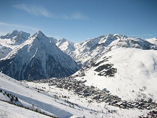
Les Deux Alpes is a ski resort in the French department of Isère, Auvergne-Rhône-Alpes. The village sits at 1,650 m (5,413 ft) and lifts run to 3,600 m (11,811 ft). It has the largest skiable glacier in Europe and is France's second oldest ski resort behind Chamonix. It has the longest, normally open full on-piste vertical available in the world. It is a 71 km (44 mi) drive southeast of Grenoble.
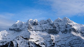
The Dents du Midi are a three-kilometre-long mountain range in the Chablais Alps in the canton of Valais, Switzerland. Overlooking the Val d'Illiez and the Rhône valley to the south, they face the Lac de Salanfe, an artificial reservoir, and are part of the geological ensemble of the Giffre massif. Their seven peaks are, from north-east to south-west: the Cime de l'Est, the Forteresse, the Cathédrale, the Éperon, the Dent Jaune, the Doigts and the Haute Cime. They are mainly composed of limestone rock, with gritty limestone rock in the upper parts.

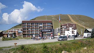
Montgenèvre is a commune of the Hautes-Alpes department in southeastern France.

The Grande Casse is the highest mountain of the Vanoise Massif in the Graian Alps in the region of Savoie, France. It is located in the heart of the Vanoise National Park, near the village of Pralognan-la-Vanoise, which is about 25 km southeast of the nearest town, Moûtiers. It has a steep 600 m high north face. The other sides of the mountain are more gentle, mostly consisting of broken rocks. A high ridge connects it to the nearby peak of Grande Motte. The ridge connecting the Grande Casse and the Grande Motte is the watershed between the Tarentaise Valley in the north and Maurienne valley to the south.
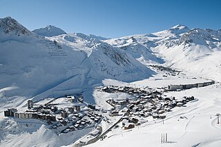
Valloire is a commune in the Savoie department in the Auvergne-Rhône-Alpes region in south-eastern France.

Villar-d'Arêne is a commune in the Hautes-Alpes department in southeastern France, between Grenoble and Briançon. It is in the French Alps, in Massif des Écrins. Near this village located in the Romanche valley, there is La Grave and Col du Lautaret. The access of the valley and its communes is departmental route 1091.

Vallorcine is a commune in the Haute-Savoie department in the Auvergne-Rhône-Alpes region in Southeastern France. In 2018, it had a population of 404.
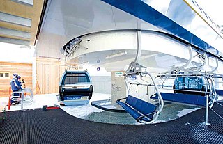
A hybrid lift is a type of ski lift that combines the elements of a chairlift and a gondola lift. First introduced by Poma, who refers to them as Telemix, they have since been built by most lift manufacturers who refer to them by a variety of names; Doppelmayr refers to them as a combined lift, Bartholet refers to them with the French name, téléporté mixte, while the more generic terms chondola and telecombi are common in North America.

Pierre Gaspard was a French mountain climber, one of the greatest mountain guides in the silver age of alpinism. He made the first ascent of La Meije on 16 August 1877 with his son and Emmanuel Boileau de Castelnau. Their ascent followed the south buttress Arête du Promontoire, which became the "normal route".


