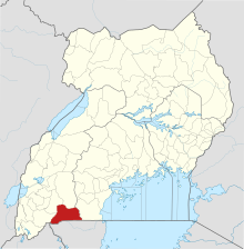
Ntungamo District is a district in Western Uganda. Like most Ugandan districts, it is named after its 'chief town', Ntungamo, the location of the district headquarters. Ntungamo was elevated to a district on 5th May 1993.

Mbarara District is a district in South Western Uganda. In 2019, the Ugandan Cabinet approved part of Mbarara District, the then-Mbarara municipality, to be upgraded to city status effective July 2020.

Lake Mburo National Park is a national park located in Nyabushozi County, Kiruhura District in Uganda.

Isingiro District is a district in the Western Region of Uganda. The town of Isingiro is the district's main municipal, administrative, and commercial center.

The Burigi-Chato National Park is a Tanzanian national park located the Karagwe, Biharamulo District, Muleba District of Kagera Region and Chato of Geita Region. With a total area of 4,707 square kilometers, Burigi-Chato is Tanzania's fourth-largest park and was designated a national park in 2019. From Lake Victoria in the east to the Rwandan border in the west, Burigi-Chato is a sizable region of uninhabited land. Hundreds of square kilometers of medium- and tall-grass wooded savanna, primarily Combretum and Terminalia known as Miombo, are found there. The largest freshwater lake is Lake Burigi, after which the park is named. Other features include long hills, rocky crags along escarpments, deeply set valleys lined with forest, open plains, swamps, rivers, flood plains, and deep valleys.

Lake Opeta is a lake with an extensive wetland system in Uganda.

Lake Bisina, also known as Lake Salisbury and Lake Bisinia, is a freshwater lake in eastern Uganda. It is a satellite lake of Lake Kyoga, which it drains into, and the two are to some extent directly connected by papyrus swamps. During the high-water rainy season, Lake Bisina can be up to 6 m (20 ft) deep and often directly connects with the smaller Lake Opeta, but during the dry season the two are clearly separated.

Lubigi is a swampy wetland on the northern and western outskirts of Kampala, the capital and largest city of Uganda.

River Rwizi is a river located in South Western Uganda in district called Mbarara. River Rwizi is a river located in southwestern Uganda. It is the second-longest river in Uganda, after the Nile River. The river originates in the hills of Buhweju District and flows through the districts of Sheema, Bushenyi, Ntungamo, Rwampara, Mbarara, Isingiro, Kiruhura, Lyantonde, Rakai, and Kyotera. It eventually empties into Lake Victoria. Many swamps feed river Rwizi, including Nyakafumura, part of the Mushasha water basin, and Kanyabukanja wetland. These marshes function as water reservoirs or catchments, gently releasing water into the river to support the surrounding population.
Sanga, is an urban center in the Kiruhura District, Ankole sub-region, in the Western Region of Uganda.

Nakivale refugee settlement is a settlement located in Isingiro District near the Tanzania border in Southwest Uganda.

Nyabushozi County is the south constituency of western Region, Ugandas district of Kiruhura. This is where Lake Mburo National Park is found. It borders with Isingiro in the south and Mbarara to the south-west The Area is commonly known for being Cattle keeping area characterised and highly occupied by indigenous Ankole Sanga Cattle.
The Isingiro–Ntantamuki–Rakai Road is a road in the Central and Western Regions of Uganda, connecting the towns of Isingiro, in Isingiro District, Western Region and Rakai in Rakai District, Central Region.
Isingiro Water Supply and Sanitation Project (IWSSP), also Isingiro Water Supply and Sewerage System is a water intake, purification, distribution and waste water collection and disposal system in Isingiro District, in the Western Region of Uganda. The project is intended to meet the water supply and sanitation needs of 340,000 people of the 550,000 inhabitants of the district. The beneficiaries include the 100,000 occupants of Nakivale Refugee Settlement and the 32,000 occupants of Oruchinga Refugee Settlement. The work is to be carried out by the Uganda Ministry of Water and Environment through the parastatal utility company, National Water and Sewerage Corporation (NWSC). Funding, have been provided by the French Development Agency and the European Union.
Masaka–Mbarara Water Supply and Sanitation Project (MMWSSP), is a water intake, purification, distribution and waste water collection and disposal system in the cities of Masaka and Mbarara in the Central Region and the Western Region of Uganda. The project is intended to meet the water supply and sanitation needs of approximately 1,055,000 by 2030. The work is to be carried out by the Uganda Ministry of Water and Environment through the parastatal utility company, National Water and Sewerage Corporation (NWSC). Funding, have been provided by the French Development Agency and the European Union.

Lake Mburo–Nakivali Wetland System is a wetland located in Mbarara district 60 km from Mbarara town in western Uganda, and East Africa, bordering Tanzania and Rwanda. The system encompasses five lakes lying in Lake Mburo National Park, including Mburo being the largest, Kigambira, Mutukula, Kazuma, and Bwara in the west-east location.

Lake Mburo is a freshwater lake located in western Uganda, situated within the Lake Mburo National Park. It is a prominent feature of the region, known for its scenic beauty and rich biodiversity.

Lake Nakivali, also known as Lake Nakivale, is a freshwater lake located in western Uganda's Isingiro District; it is part of the Lake Mburo-Nakivale wetland system. It is located about 40 kilometers south-east of Mbarara town.

Lake Kachera is also known as Lake Kachira, Lake Kacheera, Lake Kakyera and Lake Kachra is a shallow fresh water lake that is located in Rakai district and Mbarara district in Uganda. It is a part of the Mburo-Nakivale wetland system and also a part of the complex system of lakes known as Koki lakes that are separated by vast swamps. It is also one of the lakes that make the Victoria satellite lakes.

Lake Mulehe is a crater lake situated in the Kisoro District of southwestern Uganda, close to the border with Rwanda. This lake is a part of the Albertine Rift, which is well known for its biological diversity and visually striking landscapes.


