Lake Pepin

Last updated
Lake Pepin
LakePepinMississippiRiver2006-09-30.JPG
Lake from the Minnesota side
USA Wisconsin relief location map.svg
Red pog.svg
Lake Pepin
Location Goodhue / Wabasha counties in Minnesota and
Pepin County, Wisconsin
Coordinates 44°29′54″N92°18′05″W / 44.4982°N 92.3013°W / 44.4982; -92.3013
Primary inflows Mississippi River
Primary outflows Mississippi River
Basin  countriesUnited States
Surface area45.7 sq mi (118 km2)
Average depth21 ft (6.4 m)
Max. depth60 ft (18 m)
Frozenwinter
Settlements Lake City, Bay City, Pepin, Maiden Rock, Stockholm, Maple Springs, Camp Lacupolis, Reads Landing
Lake Pepin from Wisconsin side MississippiRiverBluffs.jpg
Lake Pepin from Wisconsin side

Lake Pepin is a naturally occurring lake on the Mississippi River on the border between the U.S. states of Minnesota and Wisconsin. It is located in a valley carved by the outflow of an enormous glacial lake at the end of the last Ice Age. The lake formed when the Mississippi, a successor to the glacial river, was partially dammed by a delta from a tributary stream and spread out across the ancient valley.

Contents

Lake Pepin is now a corridor for water, highway, and rail transportation. Known as the birthplace of water skiing, it hosts a variety of recreational activities.

Geography

Lake Pepin has a surface area of about 40 square miles (100 km2) and an average depth of 21 feet (6.4 m), [1] It is up to 2 miles (3.2 km) wide and 22 miles (35 km) long. [2]

The wide area of the lake stretches from Bay City, Wisconsin, in the north, down to Reads Landing, Minnesota, in the south. The villages of Pepin, Maiden Rock, and Stockholm are on the Wisconsin side, while Frontenac State Park takes up a large part of the Minnesota side. The largest city on the waterfront is Lake City, Minnesota.

The Canadian Pacific Railway now owns the former mainline of the Milwaukee Road on the Minnesota side, and the Burlington Northern's former Burlington Route mainline is lakeside on the Wisconsin side. Both were former racetracks for the premier passenger trains of their owners, and the CP rails still carry Amtrak's Empire Builder between Chicago and the Pacific Northwest. Lakeside highways are U.S. Route 61 on the Minnesota side, and across the lake Wisconsin State Highway 35 is just inland from the railroad. Both are National Scenic Byways and parts of the Great River Road.

Maiden Rock, on Lake Pepin, is one site said to be the locale where a Dakota woman named Winona leapt to her death. [3] [4]

Geology

Lake Pepin occupies a valley carved by the waters of Glacial River Warren, which drained Lake Agassiz in a catastrophic flood at the end of the last Ice Age, and to a lesser extent from Lake Duluth, a smaller glacial lake which drained through the present valley of the St. Croix River. When the continental glacier's meltwaters found other outlets to the sea, River Warren was succeeded by the more modest Upper Mississippi, which drains a much smaller basin, and the St. Croix spillway became the present river. Over a long period of time, the deep valley was partially filled with sediments, forming a broad floodplain. In this plain Lake Pepin formed behind a delta comprising sediments deposited into the ancient lake bed by the Chippewa River near the present community of Wabasha at the southern end of the lake. The lake backed up behind this sediment dam as far north as the location of Saint Paul. In the 10,000 years since the lake's creation, ongoing sedimentation into Lake Pepin has caused its upper end to migrate downstream some 80 km (50 mi) to its present location east (river direction south) of Red Wing, Minnesota. [5]

Ecology

The process of sedimentation continues at an accelerated rate; particulates carried by the river upstream are deposited when the current slows where the river empties into the lake. Pepin's natural flora are threatened by these increased rates of sedimentation, leading the Lake Pepin Legacy Alliance to call the phenomenon a "wet desert." Some theorize the lake is filling in at a rate of ten times greater than pre-colonization, due largely to increased run-off from farms along the Minnesota River. [6] Other research maintains sediment accumulation is from a more diverse and complicated series of processes, including natural bank sloughing of large amounts of soil from steep river banks, a result of the geography of the area, composition and physical properties of the soil, man-made restriction of river flooding, access to flood plains and wetlands, and forced straightening an deepening of river channels. Research suggests these processes are being heightened due to increasing precipitation due to climate change. [7] [8]

Lake Pepin Panorama.jpg
Panoramic view of Lake Pepin from Florence Township's public beach in Frontenac.

Human history

The lake was first named in a map of New France made by Guillaume Delisle at the request of Louis XIV of France in 1703. The lake was named for Jean Pepin who settled on its shores in the late 1600s after exploring the Great Lakes from Boucherville.

Nicolas Perrot erected the first of a number of fur trade posts, Fort Saint Antoine, in 1686. In 1727 René Boucher de La Perrière and Michel Guignas built Fort Beauharnois on the lake. In 1730 it had to be rebuilt on higher ground. [9] Boucher was the military leader and Father Guignas was a missionary to the Sioux.

In the nineteenth century, the lake was used to transport freshly-cut trees for the lumber industry. Cut logs were floated across the lake, from the 1840s often with the assistance of steamboats to counter adverse winds and the sluggish currents in the lake. Large rafts were assembled at Reads Landing at the southern end, and towed downstream to mills at Winona and St. Louis. [10]

In 1890, it was the site of one of the worst maritime disasters on the Mississippi, known as the Sea Wing disaster when the Sea Wing ferry capsized in a bad storm, killing 98 people. [11] In 1922, Lake City native Ralph Samuelson invented the sport of water skiing on the lake, [12] [13] and Lake City is known as "the birthplace of waterskiing." The city celebrates with a festival called Waterski Days every year on the last weekend in June. [14]

Pepin, Wisconsin, is the birthplace of author Laura Ingalls Wilder. [15] [16] In Little House in the Big Woods , the first book in her Little House series, Laura's father visits Lake Pepin in the first chapter [17] and her family visits the lake in the "Going to Town" chapter. Laura's family and their covered wagon then cross the frozen Lake Pepin in the chapter "Going West", the first chapter of the second book, Little House on the Prairie . [18]

Related Research Articles

<span class="mw-page-title-main">Mississippi River</span> Major river in the United States

The Mississippi River is the primary river, and second-longest river, of the largest drainage basin in the United States. From its traditional source of Lake Itasca in northern Minnesota, it flows generally south for 2,340 miles (3,766 km) to the Mississippi River Delta in the Gulf of Mexico. With its many tributaries, the Mississippi's watershed drains all or parts of 32 U.S. states and two Canadian provinces between the Rocky and Appalachian mountains. The main stem is entirely within the United States; the total drainage basin is 1,151,000 sq mi (2,980,000 km2), of which only about one percent is in Canada. The Mississippi ranks as the thirteenth-largest river by discharge in the world. The river either borders or passes through the states of Minnesota, Wisconsin, Iowa, Illinois, Missouri, Kentucky, Tennessee, Arkansas, Mississippi, and Louisiana.

<span class="mw-page-title-main">Pepin County, Wisconsin</span> County in Wisconsin, United States

Pepin County is a county in the U.S. state of Wisconsin. As of the 2020 census, the population was 7,318, making it the fourth-least populous county in Wisconsin; it is also the smallest county in Wisconsin by area. Its county seat is Durand.

<span class="mw-page-title-main">Lake City, Minnesota</span> City in Minnesota, United States

Lake City is a city in Goodhue and Wabasha counties in the U.S. state of Minnesota. It lies along Lake Pepin, a wide portion of the Mississippi River. The population was 5,252 at the 2020 census. Most of Lake City is located within Wabasha County with only a small portion in Goodhue County. Lake City is part of the Rochester, Minnesota Metropolitan Statistical Area.

<span class="mw-page-title-main">Driftless Area</span> Geological region in the Midwestern US

The Driftless Area, also known as Bluff Country and the Paleozoic Plateau, is a topographical and cultural region in the Midwestern United States that comprises southwestern Wisconsin, southeastern Minnesota, northeastern Iowa, and the extreme northwestern corner of Illinois. The Driftless Area is a USDA Level III Ecoregion: Ecoregion 52. The Driftless Area takes up a large portion of the Upper Midwest forest–savanna transition. The Blufflands refers to the eastern section of the Driftless area in Minnesota, due to the steep bluffs and cliffs around the river valleys. The western half is known as the Rochester Plateau, which is flatter than the Blufflands. The Coulee Region refers to the southwestern part of the Driftless Area in Wisconsin. It is named for its numerous ravines.

<span class="mw-page-title-main">Ralph Samuelson</span> Inventor of water skiing

Ralph Wilford Samuelson was the inventor of water skiing, which he first performed in the summer of 1922 in Lake City, Minnesota, just before his 19th birthday. Samuelson was already skilled at aquaplaning—standing on a board while being pulled by a powerboat—but he hoped to create something like snow skiing on the water. Lake Pepin, a wide portion of the Mississippi River between Minnesota and Wisconsin, was the venue for his experiments.

<span class="mw-page-title-main">Chippewa River (Wisconsin)</span> River in Wisconsin, United States

The Chippewa River in Wisconsin flows approximately 183 miles (294 km) through west-central and northwestern Wisconsin. It was once navigable for approximately 50 miles (80 km) of its length, from the Mississippi River, by Durand, northeast to Eau Claire. Its catchment defines a portion of the northern boundary of the Driftless Area. The river is easily accessible for bikers and pleasure seekers via the Chippewa River State Trail, which follows the river from Eau Claire to Durand.

<span class="mw-page-title-main">Savanna Portage State Park</span> United States historic place

Savanna Portage State Park is a state park in the U.S. State of Minnesota established in 1961 to preserve the historic Savanna Portage, a difficult 6-mile (9.7 km) trail connecting the watersheds of the Mississippi River and Lake Superior. The portage trail crosses a drainage divide separating the West Savanna River, which drains to the Mississippi River and the Gulf of Mexico, from the East Savanna River, which flows in an opposite direction to the Saint Louis River, Lake Superior and the Great Lakes, and the Saint Lawrence River to the Atlantic Ocean.

<span class="mw-page-title-main">Frontenac State Park</span> State park in Minnesota, United States

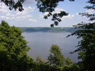
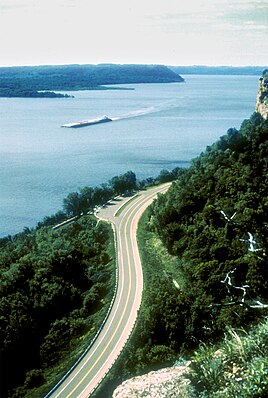
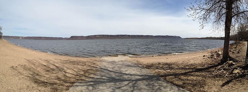
Frontenac State Park is a state park of Minnesota, United States, on the Mississippi River 10 miles (16 km) southeast of Red Wing. The park is notable both for its history and for its birdwatching opportunities. The centerpiece of the park is a 430-foot-high (130 m), 3-mile-long (4.8 km) steep limestone bluff overlooking Lake Pepin, a natural widening of the Mississippi. The bluff is variously called Garrard's Bluff or Point No-Point, the latter name coming from riverboat captains because of the optical illusion that it protruded into the Mississippi River. There is a natural limestone arch on the blufftop called In-Yan-Teopa, a Dakota name meaning "Rock With Opening". Park lands entirely surround the town of Frontenac, once a high-class resort at the end of the 19th century.

<span class="mw-page-title-main">Upper Mississippi River</span> Upstream portion of the Mississippi river

The Upper Mississippi River is today the portion of the Mississippi River upstream of St. Louis, Missouri, United States, at the confluence of its main tributary, the Missouri River. Historically, it may refer to the area above the Arkansas Post, above the confluence of Ohio River, or above Cape Girardeau.

<span class="mw-page-title-main">Lund, Wisconsin</span> Unincorporated community in Wisconsin, United States

Lund is an unincorporated community located in two counties of the U.S. state of Wisconsin. The community lies on the county line between Pepin County, in the town of Pepin, and Pierce County, in the town of Maiden Rock, in central western Wisconsin, along the junctions of County Trunk Highway SS (CTH-SS), CTH-CC(formerly WIS 183), and CTH-J. Lund is approximately nine miles northwest of Pepin and six miles northeast of Stockholm, Wisconsin.

<span class="mw-page-title-main">Geology of Minnesota</span> Overview of the geology of the U.S. state of Minnesota

The geology of Minnesota comprises the rock, minerals, and soils of the U.S. state of Minnesota, including their formation, development, distribution, and condition.

<span class="mw-page-title-main">Geography of Minnesota</span> Overview of the geography of Minnesota

The U.S. State of Minnesota is the northernmost state outside Alaska; its isolated Northwest Angle in Lake of the Woods is the only part of the 48 contiguous states lying north of the 49th parallel north. Minnesota is in the U.S. region known as the Upper Midwest in interior North America. The state shares a Lake Superior water border with Michigan and Wisconsin on the northeast; the remainder of the eastern border is with Wisconsin. Iowa is to the south, South Dakota and North Dakota are to the west, and the Canadian provinces of Manitoba and Ontario are to the north. With 87,014 square miles (225,370 km2), or approximately 2.26% of the United States, Minnesota is the 12th largest state.

<span class="mw-page-title-main">Glacial history of Minnesota</span>

The glacial history of Minnesota is most defined since the onset of the last glacial period, which ended some 10,000 years ago. Within the last million years, most of the Midwestern United States and much of Canada were covered at one time or another with an ice sheet. This continental glacier had a profound effect on the surface features of the area over which it moved. Vast quantities of rock and soil were scraped from the glacial centers to its margins by slowly moving ice and redeposited as drift or till. Much of this drift was dumped into old preglacial river valleys, while some of it was heaped into belts of hills at the margin of the glacier. The chief result of glaciation has been the modification of the preglacial topography by the deposition of drift over the countryside. However, continental glaciers possess great power of erosion and may actually modify the preglacial land surface by scouring and abrading rather than by the deposition of the drift.

<span class="mw-page-title-main">Traverse Gap</span> River channel in Minnesota, US

The Traverse Gap is an ancient river channel occupied by Lake Traverse, Big Stone Lake and the valley connecting them at Browns Valley, Minnesota. It is located on the border of the U.S. states of Minnesota and South Dakota. Traverse Gap has an unusual distinction for a valley: it is crossed by a continental divide, and in some floods, water has flowed across that divide from one drainage basin to the other. Before the Anglo-American Convention of 1818 it marked the border between British territory in the north and U.S. – or earlier, French – territory in the south.

Glacial River Warren, also known as River Warren, was a prehistoric river that drained Lake Agassiz in central North America between about 13,500 and 10,650 BP calibrated years ago. A part of the uppermost portion of the former river channel was designated a National Natural Landmark in 1966.

<span class="mw-page-title-main">Proglacial lakes of Minnesota</span>

The proglacial lakes of Minnesota were lakes created in what is now the U.S. state of Minnesota in central North America in the waning years of the last glacial period. As the Laurentide Ice Sheet decayed at the end of the Wisconsin glaciation, lakes were created in depressions or behind moraines left by the glaciers. Evidence for these lakes is provided by low relief topography and glaciolacustrine sedimentary deposits. Not all contemporaneous, these glacial lakes drained after the retreat of the lobes of the ice sheets that blocked their outlets, or whose meltwaters fed them. There were a number of large lakes, one of which, Glacial Lake Agassiz, was the largest body of freshwater known to have existed on the North American continent; there were also dozens of smaller and more transitory lakes filled from glacial meltwater, which shrank or dried as the ice sheet retreated north.

<span class="mw-page-title-main">Barn Bluff (Red Wing, Minnesota)</span> United States historic place

Barn Bluff is a bluff along the Mississippi River in Red Wing, Minnesota, United States. The bluff is considered sacred by the Dakota people because it is the site of many burial mounds. During the 19th century, the bluff functioned as a visual reference for explorers and travelers and later served as a limestone quarry.

<i>Little House on the Prairie</i> (novel) 1935 American childrens novel by Laura Ingalls Wilder

Little House on the Prairie is an autobiographical children's novel by Laura Ingalls Wilder, published in 1935. It was the third novel published in the Little House series, continuing the story of the first, Little House in the Big Woods (1932), but not related to the second. Thus, it is sometimes called the second one in the series, or the second volume of "the Laura Years".

The East Savanna River is a small yet historic stream in Aitkin and Saint Louis counties in the U.S. state of Minnesota. With a total length of 15.3 miles (24.6 km), the river rises in Wolf Lake, a small body of water within a spruce bog in Savanna Portage State Park, and flows northeasterly to the Saint Louis River at Floodwood, whence its waters flow to Lake Superior through the Great Lakes and the Saint Lawrence River to the Atlantic Ocean. A few thousand years ago the East Savanna was part of the Mississippi River itself, originating in northeast Minnesota and flowing southwesterly to Big Sandy Lake, from which the great river drained down its present valley to the Gulf of Mexico.

References

  1. "Lake Pepin Minnesota DNR".
  2. Waters, The Streams and Rivers of Minnesota, p. 220.
  3. Porter, Cynthya (Feb 1, 2009). "Homecoming To Explore Roles Of American Indian Women". Winona Daily News reprinted at Diversity Foundation. Retrieved 21 Oct 2015.
  4. "Maiden Rock History". Archived from the original on 2014-11-06. Retrieved 2011-12-20.
  5. Ojakangas, Minnesota's Geology, pp. 113-15; Waters, The Streams and Rivers of Minnesota, pp. 219-20.
  6. "Lake Pepin Legacy Alliance News". Archived from the original on 2011-05-09. Retrieved 2010-07-20.
  7. Kessler, Andrew C; Gupta, Satish C; Brown, Melinda K (2013). "Assessment of river bank erosion in Southern Minnesota rivers post European settlement". Geomorphology. 201: 312–322. Bibcode:2013Geomo.201..312K. doi:10.1016/j.geomorph.2013.07.006.
  8. Gupta, Satish C.; Kessler, Andrew C. (2017). Bank Erosion in the Minnesota River Basin. Proceedings of the 6th Soil and Water Management 2017 Field days, Lamberton, MN.{{cite book}}: CS1 maint: location (link) CS1 maint: location missing publisher (link)
  9. Quimby, Mrs. Thomas Letter to Ms. Sackett. September 23, 1928 Manuscripts/Notebooks. Minnesota Historical Society, Saint Paul, Minnesota.
  10. Waters, The Streams and Rivers of Minnesota, p. 206.
  11. "Day-long excursion on Lake Pepin turns into one of the deadliest disasters on Upper Mississippi". ECM Publishers. Archived from the original on April 17, 2008. Retrieved 2009-05-08.
  12. Ralph Samuelson, Water Ski Hall of Fame.
  13. A Look Back... Archived 2018-12-17 at the Wayback Machine , Water Ski Hall of Fame.
  14. "Water Ski Days". Lake City Chamber of Commerce.
  15. "Laura Ingalls Wilder Museum". Laura Ingalls Pepin, Wisconsin. Retrieved 2019-07-09.
  16. Stokes, Sarah. "Laura Ingalls Wilder's birthplace". www.weau.com. Retrieved 2019-07-09.
  17. Ingalls Wilder, Laura (1953). Little House in the Big Woods. HarperCollins. ISBN   9780060264307. OCLC   469503.
  18. Ingalls Wilder, Laura (7 February 2017). Little House on the Prairie. HarperCollins. ISBN   9780062470744. OCLC   1023197044.

Sources