
The Waipā River is in the Waikato region of the North Island of New Zealand. The headwaters are in the Rangitoto Range east of Te Kuiti. It flows north for 115 kilometres (71 mi), passing through Ōtorohanga and Pirongia, before flowing into the Waikato River at Ngāruawāhia. It is the Waikato's largest tributary. The Waipā's main tributary is the Puniu River.

Lake Ngaroto is a peat lake in Waipa District of New Zealand.

Te Kumi railway station was a station on the North Island Main Trunk in New Zealand. The railway had been delayed by Māori opposition to it entering King Country and Te Kumi was one of the last places where such resistance was shown.

Te Kawa railway station was a station on the North Island Main Trunk in New Zealand, located at Te Kawa.

Te Mawhai railway station was a flag station on the North Island Main Trunk in New Zealand. Its primary traffic was supplies to the nearby Tokanui Psychiatric Hospital. The hospital was situated to be convenient for freight and passengers by rail and a light railway connection to the hospital was considered.

Ngaroto railway station was a station on the North Island Main Trunk in New Zealand, 3.42 km (2.13 mi) south of Lake Rd, 2 mi (3.2 km) north of Te Awamutu, beside the entrance to Yarndley's Bush. Lake Ngaroto is visible from the railway to the north of the station.

Ōhaupō railway station was a station located at Ōhaupō on the North Island Main Trunk in New Zealand. It was the terminus of the line from Auckland from 1878 to 1880 and closed in 1982. Only a passing loop remains.

Rukuhia railway station was a flag station on the North Island Main Trunk in New Zealand, located in the settlement of Rukuhia. It was established during an extension of the railway line in the 1870s. The service started with two trains a day.

Mercer railway station in Mercer, New Zealand, is 72 km from Auckland and 609 km from Wellington on the North Island Main Trunk line. It opened on 20 May 1875 and was closed to passengers about 1970 and to goods in the 1990s. It burnt down in 1879 and also in 1900. Until 1958 it was the first refreshment stop south of Auckland.
Te Awamutu was a temporary terminus, serving the border town of Te Awamutu, on the North Island Main Trunk (NIMT) in New Zealand from 1880, when the line was extended from Ōhaupō, until 1887, when the line was extended south to Ōtorohanga.

Otorohanga railway station serves the town of Ōtorohanga, on the North Island Main Trunk in New Zealand. The current station dates from 1924.

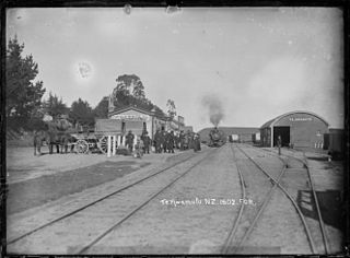
Te Kuiti railway station is a station on the North Island Main Trunk in New Zealand. The station was important in the growth of Te Kuiti.
Only 0.9% of travel in Hamilton and the Waikato Region was made by bus in 2013/14. This compares with 2.3% nationally, which itself is amongst the lowest modal shares in the world. Since 2014, the average number of trips per person per year in Waikato has declined from 10.1 to 4.7 in 2021/22, though bus trips rose slightly, from 788,600 per quarter in 2021, to 823,800 in 2023.

Raahui Pookeka-Huntly Railway Station is on the North Island Main Trunk line and the Awaroa Branch in the town of Huntly in the Waikato District of New Zealand, 65 mi (105 km) south of Auckland. It is 7.31 km (4.54 mi) north of Taupiri and 2.78 km (1.73 mi) south of Kimihia. The station was named Raahui Pookeka-Huntly for its reopening for the new Te Huia train on 6 April 2021.

Tuakau railway station was a railway station in the town of Tuakau in the Waikato District of New Zealand.

Ngāruawāhia railway station was at the junction of the North Island Main Trunk line and its Glen Massey branch, serving Ngāruawāhia in the Waikato District of New Zealand, 74 mi (119 km) south of Auckland and 10 mi (16 km) north of Hamilton. It was opened with a special train from Auckland on Monday 13 August 1877. The next stations were Taupiri 6.5 km (4.0 mi) to the north and Horotiu 5.5 km (3.4 mi) to the south.

Ohinewai Railway Station was a flag station on the North Island Main Trunk line, serving Ohinewai in the Waikato District of New Zealand, 59 mi (95 km) south of Auckland. It was 8.18 km (5.08 mi) north of Huntly, 7.26 km (4.51 mi) south of Rangiriri and 33 ft (10 m) above sea level. It was in the village, just north of Tahuna Rd.
Te Kauwhata was a flag station on the North Island Main Trunk line, in the Waikato District of New Zealand, 54 mi (87 km) south of Auckland. It was 591.52 km (367.55 mi) north of Wellington, 3.32 km (2.06 mi) north of Rangiriri, 6.72 km (4.18 mi) south of Whangamarino and 12 m (39 ft) above sea level.

Kakahi was a station on the North Island Main Trunk line, in the Ruapehu District of New Zealand, serving Kakahi. It formally opened on 9 November 1908. The rails were laid south of Piriaka by May 1904 and a daily ballast train was running by October, which also carried passengers. Kakahi Bridge has five spans of 44 ft (13 m) and one of 23 ft (7.0 m) supplied by G. Fraser & Sons of Auckland, which delayed construction to the south. It crosses the Kakahi Stream, which was sometimes called the Waitea River.

Te Rore was in the 1850s an important transhipment point on New Zealand's Waipā River, between the agriculture of the Waikato basin and its Auckland market. That was ended in 1864 by the Invasion of the Waikato, when Te Rore was, for a few months, part of the supply route to four redoubts set up nearby. It is now a rural community in the Waipa District, 6 km (3.7 mi) north of Pirongia and roughly the same distance south of Ngāhinapōuri on State Highway 39.
