Lake Swannanoa, New Jersey

Last updated
Lake Swannanoa vintage postcard Postcard 3.jpg
Lake Swannanoa vintage postcard

Lake Swannanoa is a residential lake community located within Jefferson Township, in Morris County, New Jersey, United States. [1] It is within the scenic Skylands Region and approximately 38 miles (61 km) by road from New York City.

Jefferson Township, New Jersey Township in New Jersey, United States

Jefferson Township is the northernmost township in Morris County, New Jersey, United States. As of the 2010 United States Census, the township's population was 21,314, having increased by 1,597 (+8.1%) from the 19,717 counted in the 2000 Census, which had in turn increased by 1,892 (+10.6%) from the 17,825 counted in the 1990 Census.

Morris County, New Jersey County in New Jersey

Morris County is a county located in the U.S. state of New Jersey, about 25 mi (40 km) west of New York City. According to the 2010 United States Census, the population was 492,276, up from the 470,212 at the 2000 Census, As of the 2017 Census estimate, the county's population was 499,693, making it the state's 10th-most populous county, and marking a 1.5% increase from 2010. The county is part of the New York Metropolitan Area, and its county seat is Morristown. The most populous place was Parsippany-Troy Hills Township, with 53,238 residents at the time of the 2010 Census, while Rockaway Township covered 45.55 square miles (118.0 km2), the largest total area of any municipality.

New Jersey State of the United States of America

New Jersey is a state in the Mid-Atlantic and Northeastern regions of the United States. It is located on a peninsula, bordered on the north and east by the state of New York, particularly along the extent of the length of New York City on its western edge; on the east, southeast, and south by the Atlantic Ocean; on the west by the Delaware River and Pennsylvania; and on the southwest by the Delaware Bay and Delaware. New Jersey is the fourth-smallest state by area but the 11th-most populous, with 9 million residents as of 2017, and the most densely populated of the 50 U.S. states; its biggest city is Newark. New Jersey lies completely within the combined statistical areas of New York City and Philadelphia. New Jersey was the second-wealthiest U.S. state by median household income as of 2017.

Contents

Geology and hydrology

The lake has two main sections, connected by a strait. The lake is an impoundment of Russia Brook, [2] a tributary of the Rockaway River. There are also two ponds. There is an island in the north lake called Snake Island. A smaller island, Turtle Island, is indistinguishable from the shoreline at this time.

Strait A naturally formed, narrow, typically navigable waterway that connects two larger bodies of water

A strait is a naturally formed, narrow, typically navigable waterway that connects two larger bodies of water. Most commonly it is a channel of water that lies between two land masses. Some straits are not navigable, for example because they are too shallow, or because of an unnavigable reef or archipelago.

Rockaway River river in the United States of America

The Rockaway River is a tributary of the Passaic River, approximately 35 mi (56 km) long, in northern New Jersey in the United States. The upper course of the river flows through a wooded mountainous valley, whereas the lower course flows through the populated New Jersey suburbs and former industrial area west of New York City. It drains an area of approximately 130 sq mi (340 km²).

Island Any piece of sub-continental land that is surrounded by water

An island or isle is any piece of sub-continental land that is surrounded by water. Very small islands such as emergent land features on atolls can be called islets, skerries, cays or keys. An island in a river or a lake island may be called an eyot or ait, and a small island off the coast may be called a holm. A grouping of geographically or geologically related islands is called an archipelago, such as the Philippines.

The lake has two man-made dams, one for each section of the lake. The south dam has a spillway and valve, the north dam has a large valve and overflow spillway. The dams were both rehabilitated in 1998 from the original Ringling-era fieldstone and concrete construction.

Dam A barrier that stops or restricts the flow of surface or underground streams

A dam is a barrier that stops or restricts the flow of water or underground streams. Reservoirs created by dams not only suppress floods but also provide water for activities such as irrigation, human consumption, industrial use, aquaculture, and navigability. Hydropower is often used in conjunction with dams to generate electricity. A dam can also be used to collect water or for storage of water which can be evenly distributed between locations. Dams generally serve the primary purpose of retaining water, while other structures such as floodgates or levees are used to manage or prevent water flow into specific land regions. The earliest known dam is the Jawa Dam in Jordan, dating to 3,000 BC.

Spillway structure for controlled release of flows from a dam or levee

A spillway is a structure used to provide the controlled release of flows from a dam or levee into a downstream area, typically the riverbed of the dammed river itself. In the United Kingdom, they may be known as overflow channels. Spillways ensure that the water does not overflow and damage or destroy the dam.

Valve device that regulates, directs or controls the flow of a fluid or a gas

A valve is a device that regulates, directs or controls the flow of a fluid by opening, closing, or partially obstructing various passageways. Valves are technically fittings, but are usually discussed as a separate category. In an open valve, fluid flows in a direction from higher pressure to lower pressure. The word is derived from the Latin valva, the moving part of a door, in turn from volvere, to turn, roll.

The south dam was upgraded in 2013 to meet NJDEP Dam Safety & Flood Control requirements. This was as a direct result of an unusual meteorological event, the August 2000 storm. This storm arrived and did not move for over a day, dumping 14 inches (official measurement, independent estimates say 16+ inches) of rain to a restricted area. The resultant flooding caused the main thoroughfare Berkshire Valley Road to become inundated, but did not cause either dam to fail. Excessive overflow caused some undermining of the dam structure which has since been corrected. The lake was previously under orders of the New Jersey Department of Environmental Protection (NJDEP) to maintain a water level of no greater than two and no less than three feet below spillway until the repair was completed.

New Jersey Department of Environmental Protection

The New Jersey Department of Environmental Protection (NJDEP) is a government agency in the U.S. state of New Jersey that is responsible for managing the state's natural resources and addressing issues related to pollution. NJDEP now has a staff of approximately 2,850.

Due to the large watershed, the lake both enjoys and is cursed with a high flow-through rate. The water in the lake is replaced approximately every 30–45 days. This allows for water refreshment, but makes aquatic weed treatment more challenging.

Drainage basin Area of land where precipitation collects and drains off into a common outlet

A drainage basin is any area of land where precipitation collects and drains off into a common outlet, such as into a river, bay, or other body of water. The drainage basin includes all the surface water from rain runoff, snowmelt, and nearby streams that run downslope towards the shared outlet, as well as the groundwater underneath the earth's surface. Drainage basins connect into other drainage basins at lower elevations in a hierarchical pattern, with smaller sub-drainage basins, which in turn drain into another common outlet.

Historical information

Post-Native-American settlement, the area was mostly farmland.

Native Americans in the United States Indigenous peoples of the United States (except Hawaii)

Native Americans, also known as American Indians, Indigenous Americans and other terms, are the indigenous peoples of the United States, except Hawaii. There are over 500 federally recognized tribes within the US, about half of which are associated with Indian reservations. The term "American Indian" excludes Native Hawaiians and some Alaska Natives, while Native Americans are American Indians, plus Alaska Natives of all ethnicities. Native Hawaiians are not counted as Native Americans by the US Census, instead being included in the Census grouping of "Native Hawaiian and other Pacific Islander".

Alfred T. Ringling

The property was consolidated, the lake enlarged (and two lakes combined), and a 28-room manor house with auxiliary structures were built in the rustic neoclassical style to accommodate Ringling Brothers Circus impresario Alfred T. Ringling. The estate and its auxiliary structures served as winter quarters for the R.T. Richards Circus owned and operated by Ringling's son Richard T. Ringling. Geraldine Farrar sang for the famous guests of Mr. and Mrs. Alfred T. Ringling in the music room with its great organ and Tiffany stained glass window. Ringling's death in 1919 brought an end to this era.

Peggy Winterbottom in the Alfred T. Ringling elephant barn. (Oak Ridge, NJ - April 1918) CCF03192017 - Copy.jpg
Peggy Winterbottom in the Alfred T. Ringling elephant barn. (Oak Ridge, NJ - April 1918)

The buildings are on the National Register of Historic Places. Although, the manor house has been privately owned by the St. Stanislaus Friary of the Polish Capuchins for many years, as of 2017, it is up for sale. [3]

Becoming Lake Swannanoa

The Ringling estate was purchased by Arthur D. McAllister in 1925 and renamed Lake Swannanoa. Plans were created to develop a ritzy golf and country club, the original prospectus calling for elegant high society balls, and racial/ethnic restrictions. Due to the great depression this plan never came to fruition, so instead in the 1930s it was developed as a residential community by Ringling Estates Inc. Log cabin style houses were built on small lots as primarily summer homes, and were used as such throughout the 1950s. Although there are a few weekend residents today, most houses are now occupied full-time year-round. Many of the current houses are situated on multiple original lots.

The name Swannanoa is reported to be "derived from the Cherokee word Suwali-Nunna, meaning 'trail of the Suwali tribe,'" however the name was used in this case under the impression that the translation is actually "the beautiful trail." The street names within the development are all named after Native American tribes.

Today

Lake Swannanoa (the lake, beach, and shoreline property, not the entire development) is privately owned and operated by the Lake Swannanoa Homeowners Association formerly known as the Swannanoa Sentinal Society, a private non-profit corporation. Membership is by deeded covenant. There is a fee to join the covenant, and yearly dues are assessed. Access to and use of the lake and property is by permit and restricted to members in good standing.

Related Research Articles

Benmore Dam

Benmore Dam is the largest dam within the Waitaki power scheme, located in the Canterbury Region of New Zealand's South Island. There are eight other power stations in the Waitaki Power Scheme.

Warragamba Dam dam on the Warragamba River, Australia

Warragamba Dam is a heritage-listed dam in Warragamba, Wollondilly Shire, New South Wales, Australia. It is a concrete gravity dam, which creates Lake Burragorang, the primary reservoir for water supply for the Australian city of Sydney, New South Wales.

Lake Hopatcong the largest freshwater body in New Jersey

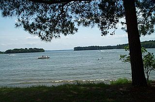
Lake Hopatcong is the largest freshwater body in New Jersey, United States, about 4 square miles (10 km²) in area. Located 30 miles from the Delaware River and 40 miles from Manhattan, New York City, the lake forms part of the border between Sussex and Morris counties in the state's northern highlands region. Lake Hopatcong was produced by damming and flooding of two ponds, known as the Great Pond and Little Pond, and the Musconetcong River, its natural outlet. Historically known as a resort lake for vacationing New Yorkers, it is now a mostly suburban residential lake.

Lake Overholser lake of the United States of America

Lake Overholser is a reservoir within the city limits of Oklahoma City, Oklahoma. Lake Overholser is formed by Overholser Dam on the North Canadian River in Oklahoma County, Oklahoma. The lake is 2.9 miles (4.7 km) west of Bethany. Lake Overholser is named after Ed Overholser who was the 16th Mayor of the City of Oklahoma City.

Oroville Dam earthfill embankment dam in Oroville, California

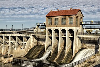
Oroville Dam is an earthfill embankment dam on the Feather River east of the city of Oroville, California, in the Sierra Nevada foothills east of the Sacramento Valley. At 770 feet (235 m) high, it is the tallest dam in the U.S. and serves mainly for water supply, hydroelectricity generation and flood control. The dam impounds Lake Oroville, the second largest man-made lake in the state of California, capable of storing more than 3.5 million acre feet.

A 1950s proposal to construct a dam near Tocks Island across the Delaware River was met with considerable controversy and protest. Tocks Island is located in the Delaware River a short distance north from the Delaware Water Gap. In order to control damaging flooding and provide clean water to supply New York City and Philadelphia, the U.S. Army Corps of Engineers proposed building a dam. When completed, the Tocks Island Dam would have created a 37-mile (60-km) long lake between Pennsylvania and New Jersey, with depths of up to 140 feet. This lake and the land surrounding were to be organized as the Tocks Island National Recreation Area. Although the dam was never built, 72,000 acres (291 km²) of land were acquired by condemnation and eminent domain. This incited environmental protesters and embittered local residents displaced by the project's preparations when their property was condemned. After the Tocks Island Dam project was withdrawn, the lands acquired were transferred to the oversight of the National Park Service which reorganized them to establish the Delaware Water Gap National Recreation Area.

Round Valley Reservoir

The Round Valley Reservoir in Clinton Township in Hunterdon County, New Jersey, United States, was formed in 1960 when the New Jersey Water Authority constructed two large dams and flooded a large valley. The reservoir is named after the naturally formed circular valley surrounded by Cushetunk Mountain. The deep valley was caused by erosion of the soft sedimentary rock. The surrounding ridges of Cushetunk Mountain endure because they were underlaid with dense and durable volcanic rock diabase that cooled slowly under the surface of the earth.

Papakating Creek

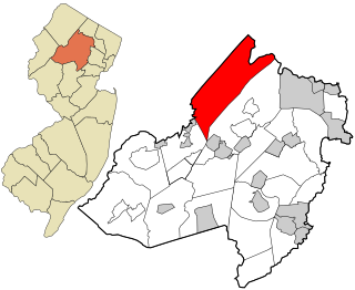
Papakating Creek is a 20.1-mile-long (32.3 km) tributary of the Wallkill River located in Frankford and Wantage townships in Sussex County, New Jersey in the United States. The creek rises in a small swamp located beneath the eastern face of Kittatinny Mountain in Frankford and its waters join the Wallkill to the east of Sussex borough.

Eucumbene Dam

Eucumbene Dam is a major gated earthfill embankment dam with an overflow ski-jump and bucket spillway with two vertical lift gates across the Eucumbene River in the Snowy Mountains of New South Wales, Australia. The dam's main purpose is for the generation of hydro-power and is one of the sixteen major dams that comprise the Snowy Mountains Scheme, a vast hydroelectricity and irrigation complex constructed in south-east Australia between 1949 and 1974 and now run by Snowy Hydro.

Croton Falls Reservoir

The Croton Falls Reservoir is a reservoir in the New York City water supply system in the Putnam County, New York townships of Carmel, and Southeast, roughly 50 miles (80 km) north of New York City. Part of the system's Croton Watershed, it was formed by impounding the West Branch and Middle Branch of the Croton River, tributaries of the Croton River, which flows into the Hudson River.

Loon Lake (California) lake in California, United States of America

Loon Lake Reservoir is a reservoir in the Eldorado National Forest of El Dorado County, California, United States. The 76,200 acre⋅ft (94,000,000 m3) lake is formed by Loon Lake Dam, completed in 1963 as part of the Upper American River Project by Sacramento Municipal Utility District to conserve spring snow melt runoff for use during the summer and autumn for hydroelectric power production. Loon Lake Dam impounds water at the headwaters of Gerle Creek which, prior to the dam, flowed intermittently through (natural) Loon and Pleasant Lakes. But most of the water now stored in Loon Lake Reservoir arrives from Buck Island Reservoir in the adjacent Rubicon River watershed by way of the Buck-Loon Tunnel. Nearby is Loon Lake Chalet, a popular winter recreation destination. In summer, a boat ramp for water sports and camping are available, but the area is less popular than nearby Union Valley Reservoir and Rubicon Trail.

Lake Livingston

Lake Livingston is a reservoir located in the East Texas Piney Woods. Lake Livingston was built, and is owned and operated, by the Trinity River Authority of Texas (TRA) under contract with the City of Houston for water-supply purposes. The lake is the second-largest lake located wholly within the state of Texas. The Livingston Dam, constructed across the Trinity River approximately 7 miles (11 km) southwest of the city of Livingston is 2.5 miles (4 km) in length and has an average depth of 55 feet (17 m).

The Ringling brothers were seven American siblings of German and French descent who transformed their small touring company of performers into one of America's largest circuses in the late 19th and early 20th centuries. Four brothers were born in McGregor, Iowa: Alf T., Charles, John and Henry, and the family lived in McGregor for twelve years, from 1860 until 1872. The Ringling family then moved to Prairie du Chien, Wisconsin, and finally settled in Baraboo, Wisconsin, in 1875. They were the children of harness maker Heinrich Friedrich August Ringling (1826–1898) of Hanover, Germany, and Marie Salome Juliar (1833–1907) of Ostheim, in Alsace. They merged their Ringling Brothers Circus with America's other leading circus troupes, ultimately creating the Ringling Bros. and Barnum & Bailey Circus.

Shadow Lake Dam is a dam on Nut Swamp Brook in Monmouth County, New Jersey. Built in 1931, it has a length of 600 feet (180 m) and is 16 feet (4.9 m) high. The dam impounds Shadow Lake. It has a main overflow spillway, an earthfill berm and an emergency spillway on the right. It has a discharge capacity of 1,912 cubic feet per second. Hubbard Road crosses over its crest.

Sunset Lake is a medium-sized reservoir located in and near the city of Bridgeton in southern New Jersey. The reservoir lies mostly in the townships of Hopewell Township and Upper Deerfield Township. The lake was created by damming a stream that feeds to the area from above Seeley Lake. And a stream that feeds into the lake from the nearby Mary Elmer Lake also located in Bridgeton. The dam is located next to Park Drive, a major roadway that cuts throughout the city's park system and interconnects with Route 49. Just across the turnpike in Deerfield it opens over in the "Silly Pond". The water from Sunset Lake flows over the spillway dam and into the Cohansey River. Originally, the lake was known as Tumbling Dam Pond.

The West Branch Mattawamkeag River is a 52.6-mile-long (84.7 km) tributary of the Mattawamkeag River in Maine. From its source in Maine Township 6, Range 6, WELS, the river runs 10 miles (16 km) northeast by Pleasant Lake and through Mud Lake and Rockabema Lake, then 42 miles (68 km) south and southeast through Upper Mattawamkeag Lake and Mattawamkeag Lake to its confluence with the East Branch Mattawamkeag River in Haynesville, about 10 miles (16 km) west of the Canada–United States border.

Pequannoc Spillway

The Pequannoc Spillway is a run-of-the-river spillway constructed in the 1920s as part of the Morris Canal system in the Pompton Plains section of Pequannock, New Jersey on one bank of the river and Wayne, New Jersey on the other bank. The spillway creates usable waterfront land out of swamps and provides water retention by creating a backwater on the Ramapo River. The structure is listed as part of the Morris Canal on the New Jersey Register of Historic Places as well as the National Register of Historic Places. It is a sister structure to the Pompton dam which lies on the Pompton River.

Neepaulakating Creek stream in Sussex County, New Jersey

Neepaulakating Creek is a 2.4-mile long (3.8 km) tributary of Papakating Creek in Wantage Township in Sussex County, New Jersey in the United States. It is one of three streams feeding the Papakating Creek, a major contributor to the Wallkill River. Although the stream was dammed in the 1950s to create Lake Neepaulin as the focal point of a private residential development, the stream did not receive a name until 2002. Residents chose a name that combined elements of the names "Neepaulin" and "Papakating", and submitted a proposal to the United States Board of Geographic Names. The name was approved in 2004.

Lake Neepaulin lake of the United States of America

Lake Neepaulin is a small man-made freshwater lake located in Wantage Township in Sussex County, New Jersey in the United States. Located in the watershed of Papakating Creek, a tributary of the Wallkill River, the lake was created in the 1950s by damming an unnamed mountain stream as the feature of a private residential development. The stream, now known as Neepaulakating Creek, did not receive a name until 2002.

References

  1. Locality Search, State of New Jersey. Accessed June 9, 2016.
  2. USGS
  3. Sweetman, Jennie (29 January 2017). "Ringling Estate recalled as famous circus is to close | Biography & History". njherald.com. New Jersey Herald. Retrieved 31 January 2017.
  1. ^ Jefferson Township Historical Society, printed reproduction postcard
  2. ^ USGS
  3. ^ Synopsis prepared by the Jefferson Township Historical Society, October 30, 1996
  4. ^ Native American Place Names
  5. ^ Weird New Jersey: 09/12/03 Carrot Wielding Little People in Jefferson Township

Coordinates: 41°00′38″N74°31′12″W / 41.0106°N 74.5201°W / 41.0106; -74.5201