Sande is a municipality in Møre og Romsdal county, Norway. It is part of the Sunnmøre region. The administrative centre is the village of Larsnes on the island of Gurskøya. Other villages in Sande include Gursken, Sandshamn, Bringsinghaug, and Voksa.
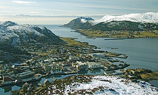
Fosnavåg (help·info) is a city in the municipality of Herøy in Møre og Romsdal county, Norway. It is the administrative center of the municipality of Herøy. The city is located on the island of Bergsøya, and it includes the Eggesbønes area on the south side of the island.

Søvik is a village and a regional service center in Haram Municipality in Møre og Romsdal county, Norway. It is located in the western part of Haram Municipality, along the sea, just southeast of the islands of Bjørnøya and Terøya. The area was part of the municipality of Borgund until 1965. The 0.74-square-kilometre (180-acre) village has a population (2013) of 728. The population density of the village is 984,838 inhabitants per square kilometre (2,550,720/sq mi). The population of Søvik and its hinterland includes about 1,050 people, almost twice the population of the village proper. The main church for Søvik is Hamnsund Church, located just outside the village in Hamnsund.
Larsnes is the administrative centre of the municipality of Sande in Møre og Romsdal county, Norway. It is located on the southwest side of the island of Gurskøya, about 8 kilometres (5.0 mi) east of the island of Kvamsøya, 8 kilometres (5.0 mi) southwest of the village of Gursken, and about 25 kilometres (16 mi) southwest of the town of Ulsteinvik.
Rovde is a former municipality in Møre og Romsdal county, Norway. The 53-square-kilometre (20 sq mi) municipality existed from 1905 until 1964. Rovde included the area on both the north and south sides of the Rovdefjorden. The northern area on the island of Gurskøya is currently part of Sande Municipality and the southern area is part of Vanylven Municipality. Rovde Church was the main church for the municipality.

The Herøyfjorden or Herøyfjord is a fjord which bisects the municipality of Herøy in Møre og Romsdal county, Norway. The fjord is about 8 kilometres (5.0 mi) long and about 2 kilometres (1.2 mi) wide, between the islands of Bergsøya and Gurskøya. The fjord has a maximum depth of 175 metres (574 ft).

Raudeberg is a village in Vågsøy Municipality in Sogn og Fjordane county, Norway. It is located on the east side of the island of Vågsøy. The villages of Refvika, Vedvika, and Langeneset are located a few kilometers to the north, and the town of Måløy is about 6 kilometres (3.7 mi) to the south. The island of Silda is located about 2 kilometres (1.2 mi) northeast of the village of Raudeberg. Nord-Vågsøy Church is located on the eastern edge of the village, right along the coast.
Kvamsøya is an island in the municipality of Sande in Møre og Romsdal county, Norway. It is located 6 kilometres (3.7 mi) east of the Stad peninsula in Selje Municipality and about 7 kilometres (4.3 mi) west of the village of Larsnes on the island of Gurskøya. The island lies in the Vanylvsgapet, the entrance to the Vanylvsfjorden.

Hareidlandet is an island in Møre og Romsdal county, Norway. The island is divided between Hareid Municipality and Ulstein Municipality. The 166-square-kilometre (64 sq mi) island has a population (2008) of 11,687. The island is mentioned by Snorri in his reports about the Battle of Hjörungavágr in 986 where Haakon Jarl defeated Bue Digre and the Jomsvikings. The island is then referred to as Höð.
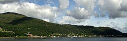
Gurskøya or Gurskøy is an island in Møre og Romsdal county, Norway. The 137-square-kilometre (53 sq mi) island is shared by the municipalities of Sande and Herøy. The villages of Gursken, Larsnes, and Moldtustranda are located on the island. The southern part of the island was historically part of the municipality of Rovde.

Vågsvåg is a village in Vågsøy Municipality in Sogn og Fjordane county, Norway. It is located on the southern shore of the island of Vågsøy along the Vågsfjorden, a part of the main Nordfjorden. The village looks across the fjord towards the island of Husevågøy.

Haus or Hausvik is a village in Osterøy municipality in Hordaland county, Norway. The village is located on the southwestern coast of the island of Osterøy along the Sørfjorden. The village lies across the Sørfjorden from the villages of Ytre Arna and Garnes. The village of Valestrandfossen lies about 7 kilometres (4.3 mi) north along the fjord. The 0.38-square-kilometre (94-acre) village has a population (2013) of 619, giving the village a population density of 1,629 inhabitants per square kilometre (4,220/sq mi).
Fotlandsvåg is a village in Osterøy municipality in Hordaland county, Norway. The village is located on the northern shore of the island of Osterøy, along the Osterfjorden. The village lies in the northeastern part of the municipality, about 6 kilometres (3.7 mi) southwest of the village of Tysso and about the same distance northeast of the village of Hosanger. The village of Ostereidet lies just across the 3-kilometre (1.9 mi) wide Osterfjorden.
Leinøy or Leinøya is an island in the municipality of Herøy in Møre og Romsdal county, Norway. Its original name was Bølandet, but Leinøy is now the common name. The island is located east of the municipal center of Fosnavåg. The island is connected to other islands via a network of bridges. The Remøy Bridge connects it to the island Remøya, the Herøy Bridge connects it to Nautøya and Gurskøya, and a small bridge connects to the island of Bergsøya.
Årset is a village in Ålesund Municipality in Møre og Romsdal county, Norway. The village is located along the Ellingsøyfjorden on the southern shore of the island of Ellingsøya, about 4 kilometres (2.5 mi) east of the village of Myklebost and about 12 kilometres (7.5 mi) west of the village of Tennfjord in Haram Municipality.
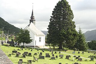
Leikanger Church is an octagonal church in the municipality of Herøy in Møre og Romsdal county, Norway. It is located in the village of Leikong on the eastern coast of the island of Gurskøya. The church is part of the Leikanger parish in the Søre Sunnmøre deanery in the Diocese of Møre.
Voksa is an island in Sande Municipality in Møre og Romsdal county, Norway. The 1.3-square-kilometre (0.50 sq mi) island lies about 2 kilometres (1.2 mi) east of the island of Kvamsøya, about 1.5 kilometres (0.93 mi) south of the island of Sandsøya, about 3.3 kilometres (2.1 mi) west of the larger island of Gurskøya, and about 1.5 kilometres (0.93 mi) north of the mainland village of Åram in neighboring Vanylven Municipality.
Sandsøya is an island in Sande Municipality in Møre og Romsdal county, Norway. The 11.4-square-kilometre (4.4 sq mi) island lies west of the island of Gurskøya, north of the island of Voksa, and northeast of the island of Kvamsøya. The main village on the island is Sandshamn on the eastern shore. The Sande Church is located on the southern shore. The island is connected to the island of Voksa to the south by a 2.5-kilometre-long (1.6 mi) bridge/road/causeway. There is a ferry connection from Voksa to the mainland, to Kvamsøya, and to the village of Larsnes on Gurskøya island.
Åram is a village in Vanylven Municipality in Møre og Romsdal county, Norway. The village is located on the mainland, about 12 kilometres (7.5 mi) straight north of the municipal centre of Fiskåbygd. The village has a ferry quay with regular connections to the nearby islands of Kvamsøya, Voksa, and Gurskøya. Åram Church is located in the village.