
Swedetown is a small, unincorporated community in Houghton County in the Upper Peninsula of the U.S. state of Michigan. It is within Calumet Charter Township at 47°14′11″N88°27′53″W, west of Osceola Road and the junction with Swedetown Road. It is south of Calumet and west of Laurium and the intersection of US 41 and M-26.
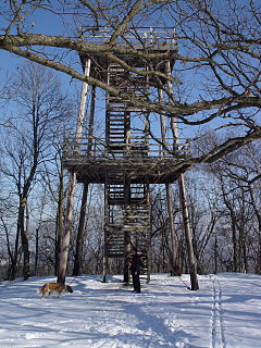
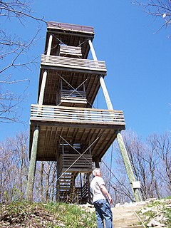
Blue Mound State Park is a state park of Wisconsin, USA, located atop the largest hill in the southern half of the state, near the village of Blue Mounds. The 1,153-acre (467 ha) park features a pair of observation towers affording views of the Wisconsin River valley and Baraboo Range to the north, the mounds, buttes, and rolling forests of the Driftless Area to the south and west, and the young glacial plains and city of Madison to the east.

Coed y Brenin is a forest in the Snowdonia National Park, North Wales near Dolgellau at grid reference SH7127. It is popular for its mountain bike trails and hiking paths. It has several man-made mountain bike singletrack courses in a woodland setting, varying in length from 12 to 38 km, and one dual slalom course.

Mountain bike racing is the competitive cycle sport discipline of mountain biking held on off-road terrain. The Union Cycliste Internationale (UCI) recognised the discipline relatively late in 1990, when it sanctioned the world championships in Durango, Colorado. The first UCI Mountain Bike World Cup series took place in 1988. Its nine-race circuit covered two continents—Europe and North America—and was sponsored by Grundig. Cross-country racing was the only World Cup sport at this time. In 1993, a six-event downhill World Cup was introduced. In 1996, cross-country mountain biking events were added to the Olympic Games. In 2006, cross-country mountain biking events became part of the World Deaf Cycling Championships for the first time in San Francisco, USA.

The Capitol State Forest is a 91,650-acre (370.9 km2) state forest in Thurston and Grays Harbor counties of the U.S. state of Washington. It includes part of the unusual Mima Mounds geologic feature.

Three Rivers Park District is a special park district serving the suburban areas of the Twin Cities including suburban Hennepin, Carver, Dakota, Scott and Ramsey counties. Three Rivers's mission is "To promote environmental stewardship through recreation and education in a natural resources-based park system." Three Rivers operates twenty parks and ten regional trails, with at least two more regional trails planned. Nearly seven million people visit Three Rivers facilities each year.
Lebanon Hills Regional Park is located in the Minnesota cities of Eagan and Apple Valley. The 1,869-acre (7.56 km2) park, the largest in Dakota County, contains forests, grasslands, marshes, and wetlands. Winter activities include skiing, snowshoeing, ice skating, ice fishing, hiking, and winter mountain biking. Summer activities include mountain biking, canoeing, kayaking, swimming, camping, horseback riding, and hiking.

Kettle Moraine is a large moraine in the state of Wisconsin, United States. It stretches from Walworth County in the south to Kewaunee County in the north. It has also been referred to as the Kettle Range and, in geological texts, as the Kettle Interlobate Moraine.
The Kettle Moraine State Forest is a state forest in southeastern Wisconsin. The chief feature of the reserve is the Kettle Moraine, a highly glaciated area. The area contains very hilly terrain and glacial landforms, such as kettles, kames and eskers. The 56,000-acre (23,000 ha) forest is divided into two large and three small units, which are spread across a hundred miles.

The Black River is a river in west-central Wisconsin and tributary of the Mississippi River. The river is approximately 190 miles (310 km) long. During the 19th century, pine logs were rafted down the Black, heading for sawmills at La Crosse and points beyond.

Pajarito Mountain Ski Area (Pajarito) is located on the north face of Pajarito Mountain, one of the Jemez Mountains in north central New Mexico, west of Los Alamos. It is located on 850 acres (3.4 km2) of privately owned land. Pajarito Mountain is owned and operated by volunteers and Mountain Capital Partners. A typical season runs from Christmas to early April, but an outstanding season may run from Thanksgiving to late April. Pajarito now has a snowmaking system and it is producing snow. Season passes are available with discounts available for early season purchase.
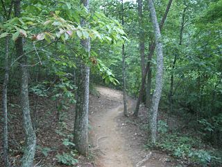
Singletrack describes a type of mountain biking trail that is approximately the width of the bike. It contrasts with double-track or fire road which is wide enough for four-wheeled off-road vehicles. It is often smooth and flowing, but may also feature technical rocky sections, go over tree roots, and include berms, banked turns, switch-backs, hills, drops, jumps, and so forth. Singletrack which descends significantly, and in the most downward direction, is said to be following the fall line.
Spring Lake Park is a public park located in Macomb, Illinois. The park is home to 230-acre (0.93 km2) Spring Lake, areas for camping, and three mountain bike trails. Spring Lake is the fresh water reservoir for the city of Macomb, and is noted for superb bass fishing that draws several regional fishing tournaments.

High Cliff State Park is a 1,187-acre (480 ha) Wisconsin state park near Sherwood, Wisconsin. It is the only state-owned recreation area located on Lake Winnebago. The park got its name from cliffs of the Niagara Escarpment, a land formation east of the shore of Lake Winnebago that stretches north through northeast Wisconsin, Upper Michigan, and Ontario to Niagara Falls and New York State.

Burke Mountain is a mountain located in the "Northeast Kingdom" of Vermont. The bulk of the mountain is in Caledonia County, but its southeast side is in Essex County. It is flanked to the east by Umpire Mountain.
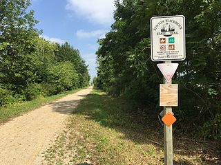
The Newton Blackmour State Trail is a crushed limestone trail in northern Outagamie County in Wisconsin. The trail spans 24 miles on a former rail corridor. The trail name is derived from the four communities the trail passes through: New London, Shiocton, Black Creek and Seymour. The trail's eastern end in Seymour connects to the Duck Creek Trail, which travels east through the Oneida Nation of Wisconsin and ends in the Village of Oneida.

The Duck Creek Trail is a crushed limestone trail in Outagamie and Brown Counties in northeast Wisconsin. The Duck Creek Trail spans 7 miles, beginning at the eastern end of the Newton Blackmour State Trail, just east of Vanderheuvel Road in Seymour. The trail continues east through the Oneida Nation of Wisconsin in northern Outagamie County paralleling State Route 54, and continues to the Village of Oneida. The Duck Creek Trail will eventually extend to Pamperin Park in Green Bay.

Farlow Gap is a popular trail for mountain biking and hiking, located in the western area of North Carolina. It is an expert-level trail, and considered "one of the toughest mountain bike trails in Pisgah National Forest." It is primarily a downhill trail, about 3.1 miles (5.0 km) in length. It can be combined with other trails to form a loop of about 14 miles (23 km), requiring anywhere from three to six hours to complete.


