The Coral Sea Islands Territory is an external territory of Australia which comprises a group of small and mostly uninhabited tropical islands and reefs in the Coral Sea, northeast of Queensland, Australia. The only inhabited island is Willis Island. The territory covers 780,000 km2 (301,160 sq mi), most of which is ocean, extending east and south from the outer edge of the Great Barrier Reef and includes Heralds Beacon Island, Osprey Reef, the Willis Group and fifteen other reef/island groups. Cato Island is the highest point in the Territory.
An islet is a very small island.

The Torres Strait is a strait which lies between Australia and the Melanesian island of New Guinea. It is approximately 150 km (93 mi) wide at its narrowest extent. To the south is Cape York Peninsula, the northernmost extremity of the Australian mainland. To the north is the Western Province of Papua New Guinea. It is named after navigator Luís Vaz de Torres, who passed through the Strait in 1606.

A tidal island is a piece of land that is connected to the mainland by a natural or man-made causeway that is exposed at low tide and submerged at high tide. Because of the mystique surrounding tidal islands many of them have been sites of religious worship, such as Mont Saint-Michel with its Benedictine Abbey. Tidal islands are also commonly the sites of fortresses because of their natural fortifications.
A bailiwick is usually the area of jurisdiction of a bailiff, and once also applied to territories in which a privately appointed bailiff exercised the sheriff's functions under a royal or imperial writ. The word is now more generally used in a metaphorical sense, to indicate a sphere of authority, experience, activity, study, or interest. A bailiwick was also the territorial division of the Teutonic Order. Here, various “Komtur(en)” formed a Ballei province.

The Shire of Torres is a local government area located in Far North Queensland, Australia, covering large sections of the Torres Strait Islands and the northern tip of Cape York Peninsula north of 11°S latitude. It holds two distinctions—it is the northernmost Local Government Area in Australia, and is the only one to abut an international border – it is at one point just 73 kilometres (45 mi) from Papua New Guinea. It is administered from Thursday Island.
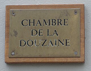
The Bailiwick of Guernsey includes the island of Guernsey and other islands such as Alderney, Sark, Herm, Jethou, Brecqhou, and Lihou. Each parish was established, probably in the 11th century, as a religious area, each having its parish church. Administratively each parish is now administered by an elected council known as a Douzaine.

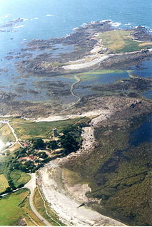
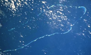
Saumarez Reef is one of the southernmost reefs to be located in the Coral Sea Islands and part of the Coral Sea Shelf; it contains three main reefs and numerous smaller reefs all of which form a large crescent-shaped formation open to the northwest, about 27 by 14 km, area less than 300 km².
.gg is the country code top-level domain for the crown dependency of Guernsey, including the islands of Guernsey, Alderney, Sark, Herm, Jethou and Lihou. The domain is administered by Island Networks, who also administer the .je domain for neighbouring territory Jersey.
HMS Zenobia was an 18-gun Cruizer-class brig-sloop launched 7 October 1807 by Brindley at King’s Lynn. Although she served during the Napoleonic Wars she is known for her role in two events, the claiming of Ascension Island for Great Britain in 1815, and the naming of the Saumarez Reefs in 1823. She was broken up in 1835.
The flagtail swellshark is a little-known species of catshark, belonging to the family Scyliorhinidae, found at a depth of 480–700 m (1,570–2,300 ft) off northeastern Queensland, and possibly also nearby islands. This stout-bodied shark has a short, broad, and flattened head with a capacious mouth. Adults have a variegated brown coloration with 9–10 darker dorsal saddles and "V"-shaped blotch at the tip of the upper caudal fin lobe. Juveniles are yellow with narrow brown bars instead of saddles, and a distinctive marking between the spiracles shaped like two loops connected by a line. Like other swellsharks, this species can inflate its body when threatened.
The Coral Sea Reserves Ramsar Site comprises the 17,292 km2 of oceanic island and reef habitats within the former Coringa-Herald National Nature Reserve and the former Lihou Reef National Nature Reserve in the Australian Coral Sea Islands Territory.
Coringa-Herald National Nature Reserve is a former nature reserve in Australia’s Coral Sea Islands Territory that was incorporated into the new Coral Sea Commonwealth Marine Reserve in December 2012. The former nature reserve together with the Lihou Reef National Nature Reserve is part of the Coral Sea Reserves Ramsar Site. Its extent is also within the Coringa-Herald Reefs Important Bird Area.
Mulena Yomuhulu Mbumu wa Litunga Yeta I was a High Chief of the Lozi people in Barotseland, Africa.
Kaurareg is the name for an indigenous Australian Torres Strait Island people. They are lower Western Islanders, based on the Muralag group. In common with the other Torres Island peoples, they commanded impressive sailing outrigger canoe technology, traded throughout the Straits, fishing and trading with other Torres island groups, and regularly visited the Australian mainland of Cape York Peninsula, with several of whose tribes they held ceremonial, marriage and trading alliances. Subject to reprisals after being blamed for an incident in which a Western schooner and its crew were destroyed, their numbers rapidly diminished with the onset of white colonization and administration. After World War II, descendants of the Kaurareg began to return to their traditional islands, and lay claim to native title over several of them.
Jack Lihou is a former first-class cricketer who played 26 matches for Queensland between 1955 and 1965.