Lima is the capital and largest city of Peru. It is located in the valleys of the Chillón, Rímac and Lurín Rivers, in the desert zone of the central coastal part of the country, overlooking the Pacific Ocean. The city is considered the political, cultural, financial and commercial center of Peru. Due to its geostrategic importance, the Globalization and World Cities Research Network has categorized it as a "beta" tier city. Jurisdictionally, the metropolis extends mainly within the province of Lima and in a smaller portion, to the west, within the Constitutional Province of Callao, where the seaport and the Jorge Chávez Airport are located. Both provinces have regional autonomy since 2002.

The Walls of Lima were a fortification consisting mainly of walls and bastions whose purpose was to defend the city of Lima from exterior attacks. It was built between 1684 and 1687, during the Viceroy Melchor de Navarra y Rocafull 's government.
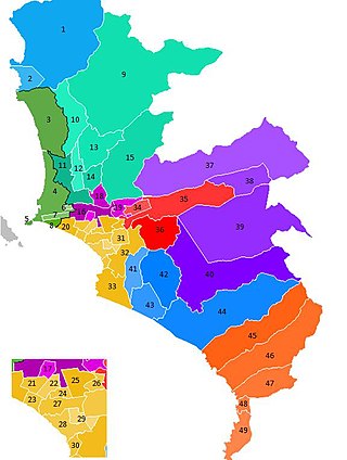
The Lima Metropolitan Area is an area formed by the conurbation of the Peruvian provinces of Lima and Callao. It is the largest of the metropolitan areas of Peru, the seventh largest in the Americas, the fourth largest in Latin America, and among the thirty largest in the world. The conurbation process started to be evident in the 1980s.

Rímac, known until the 19th century as the neighbourhood of San Lázaro, is a district in the Lima Province, Peru. It lies directly to the north of downtown Lima, to which it is connected by six bridges over the Rímac River. The district also borders the Independencia, San Martín de Porres, and San Juan de Lurigancho districts. Vestiges of Lima's colonial heyday remain today in an area of the Rímac district known as the Historic centre of Lima, which was declared a UNESCO World Heritage Site in 1988. Downtown Rímac District has, like its southern counterpart, its eastern and western sides divided by Jirón Trujillo, which connects to Lima District's Jirón de la Unión through the Puente de Piedra, the oldest bridge in the whole city. Rímac's East side features the Plaza de Acho, the most famous bullfighting arena in South America and one of the most well known in the world.

Bellavista is a district of the Constitutional Province of Callao in Peru, and one of the seven districts that comprise the port city of Callao.

Callao is one of the seven districts of the Constitutional Province of Callao in the Callao Region, Peru. The Chillón River marks the district's northern border with Ventanilla. On the east, the Callao district is bordered by the Carmen de la Legua-Reynoso as well as the Lima Province's districts of San Martín de Porres and Lima. The Bellavista and the La Perla districts are located to the southeast, while La Punta borders the district on the west. The Pacific Ocean borders the province on the west and south. At 1956, it expanded to the north, encompassing latifunds, lands and estates that belonged to the San Martín de Porres District and the Carabayllo District. During this expansion, the Jorge Chávez International Airport is built.

San Juan de Lurigancho (SJL) is a district in Lima, Peru, located in the area known as Cono Este. It is Peru's most populous district, with a current population that may exceed one million.

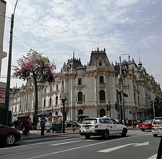
Located principally in the city centre or Cercado de Lima and Rímac areas, the Historic Centre of Lima is among the most important tourist destinations in Peru.
A Peruvian postal code is a five-digit string that comprises part of a postal address in Peru. Prior to 2011, only the major cities of Lima and Callao used postal codes. However, in February 2011 a nationwide system was implemented which employs a five-digit numeric format. Similar to the postal codes of Mexico, Brazil, Australia, the United States, and elsewhere, postal codes in Peru are strictly numerical, using only numbers.
The Jirón de la Unión, or Union Street, is a pedestrian street located in the Historic Centre of Lima, part of the capital of Peru. For many decades it was the most important boulevards of the city, often described as the most aristocratic, where many of the most affluent citizens of the city and most powerful men around the world would meet. Subsequently, with the deterioration of the center of Lima, the Jirón de la Unión lost its aristocratic character and became completely commercialized.

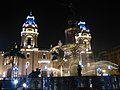
The Plaza Mayor de Lima, or Plaza de Armas de Lima, is considered one of the birthplaces of the city of Lima, as well as the core of the city. Located in the Historic Centre of Lima, it is surrounded by the Government Palace, Lima Metropolitan Cathedral, Archbishop's Palace of Lima, the Municipal Palace, and the Palacio de la Unión.

Barrios Altos is a Peruvian neighbourhood that forms the eastern part of Lima District, part of the historic centre of the city. It owes its name to the fact that, topographically, it is higher than the rest of the old part of the City, due to the elevation of the land that exists towards the Andes mountain range, which is evident in its streets to this day.
The Historic Centre of Trujillo is the main urban area and the most important center of development and unfolding in the Peruvian city of Trujillo located in La Libertad Region. The whole process of its original urban fabric is in elliptical shape surrounded by España Avenue that was built in the wake of the Wall of Trujillo. It houses the seat of city government and other important entities in the locality. In the center of this historic urban area is the Plaza de Armas of Trujillo that was the scene of the Spanish founded of the city in 1534 and the proclamation of the independence of Trujillo on December 29, 1820.

28 de Julio Avenue is one of the main avenues in the city of Lima, Peru. It extends from west to east in the districts of Jesús María, Lima and La Victoria along 31 blocks.
Jirón Amazonas is a major street in the Damero de Pizarro, located in the historic centre of Lima, Peru. The street starts at its intersection with the Jirón Lampa and continues until it reaches Sebastián Lorente Avenue.

Jirón Callao is a major street in the Damero de Pizarro, located in the historic centre of Lima, Peru. The street starts at its intersection with the Jirón Sancho de Rivera and continues until it reaches the Jirón de la Unión, next to the Plaza de Armas.
Jirón Cuzco is a major street in the Damero de Pizarro, located in the historic centre of Lima, Peru. The street starts at its intersection with the Jirón de la Unión and continues until it reaches Jirón Huánuco in Barrios Altos.

Jirón Junín is a major street in the Damero de Pizarro, located in the historic centre of Lima, Peru. The street starts at its intersection with the Jirón de la Unión and continues for 19 blocks until it reaches Nicolás Ayllón Avenue.

Jirón Trujillo is an important street in Rímac District, part of the historic centre of Lima, Peru. The street starts at the Puente de Piedra, where it is continued on the other side of the Rímac River by the Jirón de la Unión, and continues until it reaches the Alameda de los Bobos. It therefore joins the so-called monumental zones of both Rímac and Lima districts.

The Church of Saint Lazarus is a Catholic church in Rímac District, part of the Historic Centre of Lima, Peru. Built in 1586, it was the first church built in the area. Since then it has been rebuilt several times after the damage left by the various earthquakes in Peru. It is located on block five of Jirón Trujillo, at the intersection with Francisco Pizarro Avenue.