Lincoln, Buffalo County, Wisconsin

Last updated
Lincoln, Wisconsin
WIMap-doton-Lincoln c.png
Location of Lincoln, Wisconsin
Coordinates: 44°20′37″N91°44′35″W / 44.34361°N 91.74306°W / 44.34361; -91.74306 Coordinates: 44°20′37″N91°44′35″W / 44.34361°N 91.74306°W / 44.34361; -91.74306
Country Flag of the United States.svg  United States
State Flag of Wisconsin.svg  Wisconsin
County Buffalo
Area
  Total36.94 sq mi (95.68 km2)
  Land36.92 sq mi (95.62 km2)
  Water0.02 sq mi (0.06 km2)
Elevation
[1]
817 ft (249 m)
Population
 (2010)
  Total162
  Density4/sq mi (1.7/km2)
Time zone UTC-6 (Central (CST))
  Summer (DST) UTC-5 (CDT)
FIPS code 55-44300 [2]
GNIS feature ID1583562 [1]

Lincoln is a town in Buffalo County in the U.S. state of Wisconsin. The population was 162 at the 2010 census. [3] The unincorporated communities of Cream and Praag are located in the town.

Contents

Geography

According to the United States Census Bureau, the town has a total area of 36.9 square miles (95.7 km2), of which 0.023 square miles (0.06 km2), or 0.06%, is water. [3]

Demographics

As of the census [2] of 2000, there were 187 people, 79 households, and 56 families residing in the town. The population density was 5.1 people per square mile (2.0/km2). There were 106 housing units at an average density of 2.9 per square mile (1.1/km2). The racial makeup of the town was 99.47% White and 0.53% Native American.

There were 79 households, out of which 24.1% had children under the age of 18 living with them, 62.0% were married couples living together, 2.5% had a female householder with no husband present, and 29.1% were non-families. 24.1% of all households were made up of individuals, and 8.9% had someone living alone who was 65 years of age or older. The average household size was 2.37 and the average family size was 2.79.

In the town, the population was spread out, with 18.7% under the age of 18, 7.0% from 18 to 24, 25.7% from 25 to 44, 28.9% from 45 to 64, and 19.8% who were 65 years of age or older. The median age was 44 years. For every 100 females, there were 107.8 males. For every 100 females age 18 and over, there were 111.1 males.

The median income for a household in the town was $36,667, and the median income for a family was $46,875. Males had a median income of $21,875 versus $16,750 for females. The per capita income for the town was $17,768. About 5.7% of families and 6.5% of the population were below the poverty line, including 12.5% of those under the age of eighteen and none of those 65 or over.

Related Research Articles

<span class="mw-page-title-main">Grand Isle, Maine</span> Town in the state of Maine, United States

Grand Isle is a town in Aroostook County, Maine, United States. The population was 366 at the 2020 census. The village of Grand Isle is in the northwest part of the town.

<span class="mw-page-title-main">Mapleton, Maine</span> Town in the state of Maine, United States

Mapleton is a town in Aroostook County, Maine, United States. The population was 1,886 at the 2020 census.

Springfield is a town in Penobscot County, Maine, United States. The population was 293 at the 2020 census.

<span class="mw-page-title-main">Loch Lynn Heights, Maryland</span> Town in Maryland, United States

Loch Lynn Heights is a town in Garrett County, Maryland, United States. The population was 493 at the 2020 census.

<span class="mw-page-title-main">Squaw Lake, Minnesota</span> City in Minnesota, United States

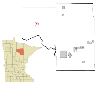
Squaw Lake is a city in Itasca County, Minnesota, United States. The population was 107 at the 2010 census.

<span class="mw-page-title-main">Tuscumbia, Missouri</span> Village in Missouri, United States

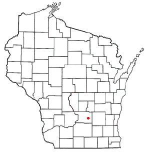
Tuscumbia is a village in and the county seat of Miller County, Missouri, United States. The population was 203 at the 2010 census, at which time it was a town.

<span class="mw-page-title-main">Tallapoosa, Missouri</span> City in Missouri, United States

Tallapoosa is a city in New Madrid County, Missouri, United States. The population was 168 at the 2010 census.

<span class="mw-page-title-main">Ashland Township, Clarion County, Pennsylvania</span> Township in Pennsylvania, United States

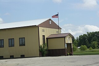
Ashland Township is a township in Clarion County, Pennsylvania, United States. The population was 1,119 at the 2020 census, an increase from the figure of 1,114 tabulated in 2010.

<span class="mw-page-title-main">Utica, Pennsylvania</span> Borough in Pennsylvania, United States

Utica is a borough in Venango County, Pennsylvania, United States. The population was 184 at the 2020 census.

<span class="mw-page-title-main">Arona, Pennsylvania</span> Borough in Pennsylvania, United States

Arona is a borough in Westmoreland County, Pennsylvania, United States. The population was 253 at the 2020 census.

<span class="mw-page-title-main">Junior, West Virginia</span> Town in West Virginia, United States

Junior is a town in Barbour County, West Virginia, United States, situated along the Tygart Valley River. The population was 384 at the 2020 census.

<span class="mw-page-title-main">Brandonville, West Virginia</span> Town in West Virginia, United States

Brandonville is a town in northern Preston County, West Virginia, United States. The population was 136 at the 2020 census. It is part of the Morgantown metropolitan area.

<span class="mw-page-title-main">Bruceton Mills, West Virginia</span> Town in West Virginia, United States

Bruceton Mills is a town in northern Preston County, West Virginia, United States, along Big Sandy Creek. The population was 64 at the 2020 census. It is part of the Morgantown metropolitan area.

<span class="mw-page-title-main">Harman, West Virginia</span> Town in West Virginia, United States

Harman is a town in Randolph County, West Virginia, United States. The population was 96 at the 2020 census.

<span class="mw-page-title-main">Womelsdorf (Coalton), West Virginia</span> Town in West Virginia, United States

Womelsdorf (Coalton) is a town in Randolph County, West Virginia, United States. The population was 190 at the 2020 census.

<span class="mw-page-title-main">Milton, Buffalo County, Wisconsin</span> Town in Wisconsin, United States

Milton is a town in Buffalo County in the U.S. state of Wisconsin. The population was 534 at the 2010 census. The unincorporated community of Czechville is located in the town.

<span class="mw-page-title-main">Otsego, Wisconsin</span> Town in Wisconsin, United States

The Town of Otsego is located in Columbia County, Wisconsin, United States. The population was 757 at the 2000 census. The unincorporated community of Otsego is located in the town. The villages of Rio and Doylestown lie in the geographic area of the town of Otsego.

<span class="mw-page-title-main">Empire, Wisconsin</span> Town in Wisconsin, United States

Empire is a town in Fond du Lac County, Wisconsin, United States. The population was 2,620 at the 2000 census.

<span class="mw-page-title-main">Morgan, Wisconsin</span> Town in Wisconsin, United States

Morgan is a town in Oconto County, Wisconsin, United States. The population was 882 at the 2000 census. The unincorporated communities of Morgan and Sampson are located in the town.

<span class="mw-page-title-main">Isabelle, Wisconsin</span> Town in Wisconsin, United States

Isabelle is a town in Pierce County, Wisconsin, United States. The population was 315 at the 2000 census. The unincorporated community of Oakridge is located in the town.

References

  1. 1 2 "US Board on Geographic Names". United States Geological Survey. 2007-10-25. Retrieved 2008-01-31.
  2. 1 2 "U.S. Census website". United States Census Bureau . Retrieved 2008-01-31.
  3. 1 2 "Geographic Identifiers: 2010 Demographic Profile Data (G001): Lincoln town, Buffalo County, Wisconsin". U.S. Census Bureau, American Factfinder. Archived from the original on February 12, 2020. Retrieved May 20, 2014.