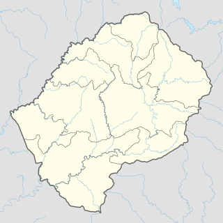
Liphofung Historical Site

Last updated
Liphofung Historical Site
Lesotho rel location map.svg
Archaeological site icon (red).svg
location in Lesotho
Location Clarens sandstone
Region Lesotho
Coordinates 28°47′4″S28°14′1″E / 28.78444°S 28.23361°E / -28.78444; 28.23361 Coordinates: 28°47′4″S28°14′1″E / 28.78444°S 28.23361°E / -28.78444; 28.23361
History
Periods Neolithic
Cultures San people

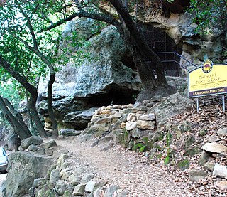
The Liphofung (“place of the eland”) Historical Site includes a cave which occupies an important place in Lesotho history. It is the smallest of the Lesotho Highlands Development Authority (LHDA) reserves, at about 4.5 ha (11 acres), but has been intensively developed. The cave is a large overhang in the Clarens sandstone, which is a typical feature of the Lesotho lowlands region. Originally used by the San people and other Neolithic people, the walls contain important rock art and a rich archaeological deposit of Stone Age implements lies beneath the floor. Later, King Moshoeshoe the Great used the cave as a stopover when visiting that part of the kingdom.

Lesotho kingdom in southern Africa

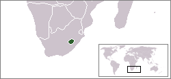
Lesotho, officially the Kingdom of Lesotho, is an enclaved country–the only one in the world outside of the Italian peninsula–within the border of South Africa. It is just over 30,000 km2 (11,583 sq mi) in size and has a population of around 2 million. Its capital and largest city is Maseru.

San people members of various indigenous hunter-gatherer people of Southern Africa

The San or Saan peoples, also known as the Bushmen, are members of various Khoesān-speaking indigenous hunter-gatherer groups that are the first nations of Southern Africa, and whose territories span Botswana, Namibia, Angola, Zambia, Zimbabwe, Lesotho and South Africa. There is a significant linguistic difference between the northern peoples living between the Okavango River in Botswana and Etosha National Park in northwestern Namibia, extending up into southern Angola; the central peoples of most of Namibia and Botswana, extending into Zambia and Zimbabwe; and the southern people in the central Kalahari towards the Molopo River, who are the last remnant of the previously extensive indigenous Sān of South Africa.

The Neolithic, the final division of the Stone Age, began about 12,000 years ago when the first development of farming appeared in the Epipalaeolithic Near East, and later in other parts of the world. The division lasted until the transitional period of the Chalcolithic from about 6,500 years ago, marked by the development of metallurgy, leading up to the Bronze Age and Iron Age. In Northern Europe, the Neolithic lasted until about 1700 BC, while in China it extended until 1200 BC. Other parts of the world remained broadly in the Neolithic stage of development, although this term may not be used, until European contact.

The site is located in a tributary-stream valley of the Hololo River, off the main route from Butha-Buthe to Oxbow and Mokhotlong. Access is via a concrete road which is passable for all vehicles. A visitors' centre, featuring a display of Basotho culture and San rock art has been developed, along with restrooms and a small shop. The site is a popular destination of school groups and tourists traveling to Oxbow, and light refreshments are available. [1]

Butha-Buthe Place in Butha-Buthe District, Lesotho

Butha-Buthe is the capital city or camptown of the Butha-Buthe District in Lesotho. It has a population of 35,108. It is named for Butha-Buthe Mountain to the north of the town, which King Moshoeshoe I used as his a fortification and headquarters from 1821 to 1823, during his war with the Zulu king Shaka. The city's name means "place of deposits."

Mokhotlong city

Mokhotlong is a city and seat of Mokhotlong District in the mountainous northeastern part of Lesotho. It is the first major city with an airport along the road from South Africa across the Sani Pass, near the Maloti Mountains. The name of the city is a word in Sesotho, the language of the people of Lesotho, meaning "Place of the Bald Ibis." Thabana Ntlenyana, the highest point in southern Africa is found in Mokhotlong.

Apart from the cultural and historical aspects of the site, there are also various geological features to be seen, both on-site and in the surrounding areas. Since the 'Moteng Valley is densely populated, it is a good opportunity to observe the traditional Basotho way of life.

Moteng Community Council in Butha-Buthe District, Lesotho

'Moteng is a community council located in the Butha-Buthe District of Lesotho. Its population in 2006 was 16,838.

Sotho people ethnic group

The Sotho people, or Basotho, are a Bantu ethnic group of Southern Africa, native to modern Lesotho and South Africa, who speak Sesotho. The Basotho have inhabited that region since around the fifth century and so are closely related to other Bantu peoples of the region.

The site was developed almost entirely by local labour and artisans; therefore, most of the development costs have been ploughed directly back into the local community. This, in turn, has led to a strong sense of ownership of the facility by the local communities. [2]

Related Research Articles

Drakensberg mountain range in South Africa

The Drakensberg is the name given to the eastern portion of the Great Escarpment, which encloses the central Southern African plateau. The Great Escarpment reaches its greatest elevation in this region – 2,000 to 3,482 metres. It is located in South Africa and Lesotho.

Rock art human-made markings on natural stone

In archaeology, rock art is human-made markings placed on natural stone; it is largely synonymous with parietal art. A global phenomenon, rock art is found in many culturally diverse regions of the world. It has been produced in many contexts throughout human history, although the majority of rock art that has been ethnographically recorded has been produced as a part of ritual. Such artworks are often divided into three forms: petroglyphs, which are carved into the rock surface, pictographs, which are painted onto the surface, and earth figures, formed on the ground. The oldest known rock art dates from the Upper Palaeolithic period, having been found in Europe, Australia, Asia and Africa. Archaeologists studying these artworks believe that they likely had magico-religious significance.

Clocolan Place in Free State, South Africa

Clocolan, established in 1906, is a small town in the Free State Province of South Africa. The Basotho called the place Hlohlolwane. New inhabitants mispronounced the name and called it Clocolan.

Teyateyaneng Place

Teyateyaneng is a town located in the district of Berea in Lesotho. Usually abbreviated to T.Y., Teyateyaneng takes its name from the two twin rivers which run on the north and the South. Both rivers lead to the Mohokare, or the Caledon River which forms the western boundary with South Africa. They are both named for their vast quantities of sand which means rapid dipping of feet as one crosses them, leading to both names which may well suggest that this is a 'place of quick sands'. Teyateyaneng is also the camptown for the district of Berea. In 2005 it had a population of 75,115.

Tsodilo archaeological site

The Tsodilo Hills are a UNESCO World Heritage Site (WHS), consisting of rock art, rock shelters, depressions, and caves. It gained its WHS listing in 2001 because of its unique religious and spiritual significance to local peoples, as well as its unique record of human settlement over many millennia. UNESCO estimates there are over 4500 rock paintings at the site. The site consists of a few main hills known as the Child Hill, Female Hill, and Male Hill.

Catholic Church in Lesotho

The Catholic Church in Lesotho is part of the worldwide Catholic Church, under the spiritual leadership of the Pope in Rome. Approximately 90 percent of the population are Christians, of whom half are Catholics. Muslims, members of other non-Christian religions, and atheists constitute the remaining 10 percent. Christians are scattered throughout the country, while Muslims live mainly in the northeastern part of the country. Most practitioners of Islam are of Asian origin, while the majority of Christians are the indigenous Basotho.

Prehistoric Iberia aspect of history of Spain and Portugal

The prehistory of the Iberian Peninsula begins with the arrival of the first hominins 1.2 million years ago and ends with the Punic Wars, when the territory enters the domains of written history. In this long period, some of its most significant landmarks were to host the last stand of the Neanderthal people, to develop some of the most impressive Paleolithic art, alongside southern France, to be the seat of the earliest civilizations of Western Europe and finally to become a most desired colonial objective due to its strategic position and its many mineral riches.

Morija Arts & Cultural Festival

Morija Arts & Cultural Festival, also known as Morija Festival, is an annual event held in Morija, a large village in the Maseru District of Lesotho. This hugely successful event is coordinated by the Morija Museum & Archives, with support from many groups including, the Royal Family and the Government of Lesotho.

Thaba Bosiu cemetery in Lesotho

Thaba Bosiu is a sandstone plateau with an area of approximately 2 km2 and a height of 1,804 meters above sea level. It is located between the Orange and Caledon Rivers in the Maseru District of Lesotho, 24 km east of the country's capital Maseru. It was once the capital of Lesotho, having been King Moshoeshoe's stronghold.

HIV/AIDS in Lesotho

HIV/AIDS in Lesotho constitutes a very serious threat to the Basotho people and Lesotho's economic development. Since its initial detection in 1986, HIV/AIDS has spread at alarming rates in Lesotho. In 2000, King Letsie III declared HIV/AIDS a natural disaster. According to the Joint United Nations Programme on HIV/AIDS (UNAIDS) in 2016, Lesotho's adult prevalence rate of 25% is the second highest in the world, following Swaziland.

Chumash Painted Cave State Historic Park

Chumash Painted Cave State Historic Park is a unit in the state park system of California, preserving a small sandstone cave adorned with rock art attributed to the Chumash people. Adjoining the small community of Painted Cave, the site is located about 2 miles (3.2 km) north of California State Route 154 and 11 miles (18 km) northwest of Santa Barbara. The 7.5-acre (3.0 ha) park was established in 1976.

LGBT rights in Lesotho

Lesbian, gay, bisexual, and transgender (LGBT) persons in Lesotho face legal challenges not experienced by non-LGBT residents. Lesotho does not recognise same-sex marriages or civil unions, nor does it ban discrimination on the basis of sexual orientation or gender identity.

Rock art of the Iberian Mediterranean Basin World Heritage Site in Spain

The group of over 700 sites of prehistoric Rock art of the Iberian Mediterranean Basin, also known as Levantine art, were collectively declared a World Heritage Site by UNESCO in 1998. The sites are in the eastern part of Spain and contain rock art dating to the Upper Paleolithic or Mesolithic periods of the Stone Age. The art consists of small painted figures of humans and animals, which are the most advanced and widespread surviving from this period, certainly in Europe, and arguably in the world, at least in the earlier works. It is notable for the number of places included, the largest concentration of such art in Europe. Its name refers to the Mediterranean Basin; however, while some sites are located near the sea, many of them are inland in Aragon and Castilla–La Mancha; it is also often referred to as Levantine Art.

Modderpoort

Modderpoort, also known as Lekhalong la Bo Tau or ‘The Pass of the Lions’, is the site in the eastern Free State, South Africa, where the Anglican Missionary Brotherhood, the Brotherhood of St Augustine of Hippo, was established by Bishop Edward Twells in the late 1860s. It is also associated with the BaSotho prophetess Mantsopa, while the ‘sacred landscape’ in the vicinity includes San rock painting sites.

Kome Caves

The Kome Caves are a group of cave dwellings made out of mud in the district of Berea, Lesotho 25 km east of Teyateyaneng.The caves are still inhabited by the descendants of the original people who built the caves. The site has been classified as a National Heritage Site.

For thousands of years, a pilgrimage has been made by the Basotho people to a network of sacred caves to communicate with the spiritual world. The caves also contain dinosaur footprints and ancient rock paintings. The caves are located between the eastern parts of the Free State and Lesotho. These sacred caves are often described as 'the key to religion' in Southern Africa.

Basotho blanket

The Basotho blanket is a distinctive form of woollen tribal blanket traditionally worn by Sotho people and unique to the Kingdom of Lesotho. Originally gifted to the then ruler King Moshoeshoe I by a British man known only as "Mr Howell" in the late 19th Century, these blankets quickly gained popularity in the Lesotho region.

Bull Cave (Cave) Cave near Campbelltown containing Aboriginal rock art depicting cattle with horns, painted by Tharawal people who had seen the escaped cattle at Camden before they were found by the British.

Bull Cave is a heritage-listed art site at Darling Avenue, Kentlyn, City of Campbelltown, New South Wales, Australia. It is also known as Bull's Cave and The Bull Cave. It was added to the New South Wales State Heritage Register on 28 August 2017.

References

  1. Liphofung Cave and Cultural Historical Site Archived 2012-06-29 at the Wayback Machine . Retrieved 2012-06-18.
  2. Liphofung brochure [ permanent dead link ] Retrieved 2012-06-18.