In Northern Ireland, the term listed building refers to a building or other structure officially designated as being of "special architectural or historic interest".[1] Grade A structures are those considered to be "buildings of greatest importance to Northern Ireland including both outstanding architectural set-pieces and the least altered examples of each representative style, period and type."[2] Once listed, severe restrictions are imposed on the modifications allowed to a building's structure or its fittings. Listed building consent must be obtained from local authorities prior to any alteration to such a structure.[1]
Listing began later in Northern Ireland than in the rest of the UK: the first provision for listing was contained in the Planning (Northern Ireland) Order 1972;[3] and the current legislative basis for listing is the Planning (Northern Ireland) Order 1991.[2] Under Article 42 of the Order, the relevant Department of the Northern Ireland Executive is required to compile lists of buildings of "special architectural or historic interest". Since 2016, the responsibility for the listing process rests with the Historic Environment Division of the Department for Communities (DfC).[4]
Following the introduction of listing, an initial survey of Northern Ireland's building stock was begun in 1974.[5] By the time of the completion of this First Survey in 1994, the listing process had developed considerably, and it was therefore decided to embark upon a Second Survey, which is still ongoing, to update and cross-check the original information. Information gathered during this survey, relating to both listed and unlisted buildings, is entered into the publicly accessible Northern Ireland Buildings Database.[5] A range of listing criteria, which aim to define architectural and historic interest, are used to determine whether or not to list a building.[2]
County Antrim covers 2,844 square kilometres (1,098sqmi), and has a population of around 616,000. The County has 79 Grade A listed buildings, of which 37 are located within the city of Belfast.
In the United Kingdom a listed building is a structure of particular architectural and/or historic interest deserving of special protection. Such buildings are placed on one of the four statutory lists maintained by Historic England in England, Historic Environment Scotland in Scotland, Cadw in Wales, and the Northern Ireland Environment Agency in Northern Ireland. The term has also been used in the Republic of Ireland, where buildings are protected under the Planning and Development Act 2000, although the statutory term in Ireland is "protected structure".
Marquess of Donegall is a title in the Peerage of Ireland held by the head of the Chichester family, originally from Devon, England. Sir John Chichester sat as a Member of Parliament and was High Sheriff of Devon in 1557. One of his sons, Sir Arthur Chichester, was Lord Deputy of Ireland from 1605 to 1616. In 1613, he was raised to the Peerage of Ireland as Baron Chichester, of Belfast in County Antrim. He died childless in 1625 when the barony became extinct.
Stranmillis University College is a university college of Queen's University Belfast. The institution is located on the Stranmillis Road in Belfast. It had 1,210 students in 2019/20. The school offers the BEd, PGCE and TESOL, as well as other courses.
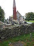
Ballintoy is a small village, townland and civil parish in County Antrim, Northern Ireland. It is alongside the B15 coast road, 28 km (17 mi) north-east of Coleraine, 8 km (5.0 mi) west of Ballycastle and between it and Bushmills. It is in the historic barony of Cary. The village lies about one kilometre from Ballintoy Harbour, a small fishing harbour at the end of a very small, narrow, steep road down Knocksaughey hill which passes by the entrance to Larrybane and Carrick-a-Rede Rope Bridge. The harbour is host to a dawn service on Easter Sunday each year.
Antrim is a town and civil parish in County Antrim in the northeast of Northern Ireland, on the banks of the Six Mile Water, on the northeast shore of Lough Neagh. It had a population of 25,606 people in the 2021 Census. It is the county town of County Antrim and was the administrative centre of Antrim Borough Council until its 2015 merger with Newtownabbey Borough Council. It is 22 miles (35 km) northwest of Belfast.
Doagh is a village and townland in County Antrim, Northern Ireland. It is in the Six Mile Water Valley, about two miles south-west of Ballyclare, and had a population of 1,388 people in the 2011 census. It is known as Doach in Scots.
Belfast City Centre is the central business district of Belfast, Northern Ireland.
Belfast Castle is a mansion located in Cave Hill Country Park in Belfast, Northern Ireland, in a prominent position 400 feet (120 m) above sea level. Its location provides unobstructed views over the City of Belfast and Belfast Lough. There have been several different structures called 'Belfast Castle' over the centuries, located on different sites. The current 'castle' is a Victorian structure, built between 1867 and 1870 on the slopes of Cave Hill, and is listed as being Grade B+. The main entrance into the Belfast Castle Demesne is now where Innisfayle Park meets Downview Park West, just off the Antrim Road. The original main entrance into the current demesne was formerly on the Antrim Road itself, where Strathmore Park now meets the Antrim Road.
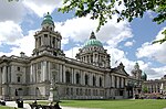
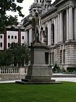
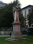
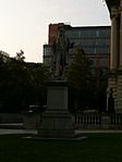
Donegall Square is a square in the centre of Belfast, County Antrim, Northern Ireland. In the centre is Belfast City Hall, the headquarters of Belfast City Council. Each side of the square is named according to its geographical location, i.e. Donegall Square North, South, East and West. It is named after the Donegall family. Other streets to bear their name in Belfast are Donegall Road, Donegall Pass and Donegall Street. Donegall Place, the city's main shopping street, runs from the north side of the square.
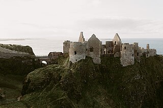
Dunluce Castle is a now-ruined medieval castle in Northern Ireland, the seat of Clan MacDonnell. It is located on the edge of a basalt outcropping in County Antrim, and is accessible via a bridge connecting it to the mainland. The castle is surrounded by extremely steep drops on either side, which may have been an important factor to the early Christians and Vikings who were drawn to this place where an early Irish fort once stood.
Sir Charles Lanyon DL, JP was an English architect of the 19th century. His work is most closely associated with Belfast, Northern Ireland.
Stranmillis is an area in south Belfast, Northern Ireland. It is also an electoral ward for Belfast City Council, part of the Laganbank district electoral area. As part of the Queen's Quarter, it is the location for prominent attractions such as the Ulster Museum and Botanic Gardens. The area is located on Stranmillis Road, with Malone Road to the west and the River Lagan to the east. Its name, meaning "the sweet stream" in Irish, refers to the Lagan, whose waters are still fresh at this point, before becoming brackish as the river flows onward toward its mouth in Belfast Lough.
Thomas Francis Ord Rippingham was an English-born architect who spent most of his professional life in Northern Ireland, mainly working for the Northern Ireland Civil Service (NICS).
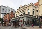
Great Victoria Street in Belfast, Northern Ireland, is a major thoroughfare located in the city centre and is one of the important streets used by pedestrians alighting from Belfast Great Victoria Street railway station and walking into shopping streets such as Royal Avenue.
Clifton House is an 18th-century Grade A listed building located in Belfast, Northern Ireland. Originally built as a poor house by the Belfast Charitable Institution. Today it is houses a heritage centre alongside a residential home and sheltered accommodation apartments.
This page is based on this Wikipedia article Text is available under the CC BY-SA 4.0 license; additional terms may apply. Images, videos and audio are available under their respective licenses.


