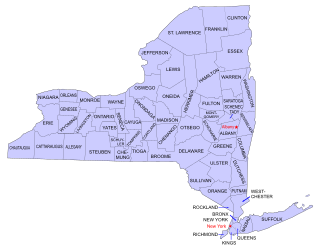
Rensselaer County is a county in the U.S. state of New York. As of the 2020 census, the population was 161,130. Its county seat is Troy. The county is named in honor of the family of Kiliaen van Rensselaer, the original Dutch owner of the land in the area.
Pittstown is a town in Rensselaer County, New York, United States. The population was 5,735 at the 2010 census. It is in the northern part of the county.
Rensselaer is a city in Rensselaer County, New York, United States, and is located on the east side of the Hudson River, directly opposite of Albany. As of the 2020 census, the city population was 9,210. Rensselaer is on the western border of Rensselaer County. The area now known as the City of Rensselaer was settled by the Dutch in the 17th century, who called it t'Greyn Bos, which became Greenbush in English. The city has a rich industrial history stretching back to the 19th century, when it became a major railroad hub; In 2020, Albany-Rensselaer was the ninth busiest Amtrak station in the country and the second busiest in New York State. Rensselaer was one of the earliest locations of the dye industry in the United States, and was the first American location for the production of aspirin.
Sand Lake is a town in south-central part of Rensselaer County, New York, United States. Sand Lake is about 13 miles east of Albany, New York. Within the town are three hamlets: Averill Park, Glass Lake and the hamlet of Sand Lake. Its four lakes are a source of recreation. Many commercial enterprises of the 19th century and into the 20th century relied on power generated from the Wynants Kill Creek and Burden Lake mills. The area is known for fertile soil for grazing and agriculture. The estimated population for 2016 census was 8,490.
Schodack is a town in Rensselaer County, New York, United States. The population was 12,965 at the 2020 census. The town name is derived from the Mahican word, Escotak. The town is in the southwestern part of the county. Schodack is southeast of Albany, New York.
The Albany Rural Cemetery was established October 7, 1844, in Colonie, New York, United States, just outside the city of Albany, New York. It is renowned as one of the most beautiful, pastoral cemeteries in the U.S., at over 400 acres (1.6 km2). Many historical American figures are buried there.
Buildings, sites, districts, and objects in New York listed on the National Register of Historic Places:
This list is intended to be a complete compilation of properties and districts listed on the National Register of Historic Places in Rensselaer County, New York, United States. Seven of the properties are further designated National Historic Landmarks.
List of the National Register of Historic Places listings in Suffolk County, New York.
Schuyler Mansion is a historic house at 32 Catherine Street in Albany, New York. The brick mansion is now a museum and an official National Historic Landmark. It was constructed from 1761 to 1765 for Philip Schuyler, later a general in the Continental Army and early U.S. Senator, who resided there from 1763 until his death in 1804. It was declared a National Historic Landmark on December 24, 1967. It is also a contributing property to the South End–Groesbeckville Historic District, listed on the National Register of Historic Places in 1984.
The Crailo State Historic Site is a historic, fortified brick manor house in Rensselaer, New York which was built in 1707. The word Crailo is derived from kraaien bos and refers to Kiliaen van Rensselaer's estate in Huizen, Holland, which is also named "Crailo". Fort Crailo is listed on the National Register of Historic Places.
The Bennington Battlefield is the Rensselaer County, New York, location where the Battle of Bennington occurred on the 16th of August 1777. It is located on New York State Route 67 in Walloomsac, New York, a historic route between Bennington, Vermont and the Hudson River. Here, New Hampshire, Vermont and Massachusetts militia under General John Stark rebuffed a British attempt led by Colonel Friedrich Baum to capture American stores. It was declared a National Historic Landmark in 1961. A portion of the battlefield is preserved in the Bennington Battlefield State Historic Site.
Buskirk Bridge is a wooden covered bridge and is the name of the hamlet in which it is located. It is in the town of Hoosick. The bridge, which crosses the Hoosic River is one of 29 historic covered bridges in New York State. The bridge takes its name from the nearby hamlet of the same name, which was named after the local Van Buskirk family.
Jacob Rutsen Van Rensselaer was an American lawyer and Federalist politician who served as Speaker of the New York State Assembly from 1812 to 1813, and Secretary of State of New York, from 1813 to 1815.
William Henry Ludlow House is a historic home located at Claverack in Columbia County, New York, next to the Ludlow-Van Rensselaer House. It was built in 1786 and is a Georgian-style residence. It is a 2+1⁄2-story, five-bay center-entrance, brick dwelling. The south facade features a finely crafted Palladian window. Also on the property are four large stone gate posts and an original mile marker. There are 10 fireplaces. Outbuildings include the original summer kitchen, root cellar, ice house and a new carriage house. The house underwent a historically correct restoration in 2011.
Kinderhook Creek is a 49.0-mile-long (78.9 km) tributary to Stockport Creek, an inlet of the Hudson River in the United States. From its source in Hancock, Massachusetts, the creek runs southwest through the Taconic Mountains into Rensselaer County, New York, and then into Columbia County. It flows through the towns of Stephentown, New Lebanon, Nassau, Chatham, Kinderhook and Stuyvesant to its mouth at Stockport Creek in the town of Stockport.
Lansingburgh Village Burial Ground is a historic cemetery located in the Lansingburgh section of Troy in Rensselaer County, New York. It was founded in 1771 and contains approximately 350 graves dating to 1912. It contains a number of notable sandstone, marble, and granite markers that offer a complete catalog of gravestone art from the late 18th through the 19th century.
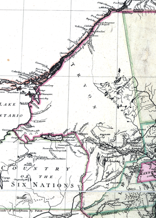
Tryon County was a county in the colonial Province of New York in the British American colonies. It was created from Albany County on March 24, 1772, and was named for William Tryon, the last provincial governor of New York. The county's boundaries extended much further than any current county. Its eastern boundary with the also-new Charlotte County ran "from the Mohawk River to the Canada line, at a point near the old village of St. Regis and passing south to the Mohawk between Schenectady and Albany." It extended north to the St. Lawrence River; its western boundary was the Treaty of Fort Stanwix's Line of Property, following the Unadilla River, Oneida Lake, Onondaga River and Oswego River to Lake Ontario, as the Iroquois Confederacy still controlled locations further west in the Indian Reserve. Tryon County's seat was Johnstown, which is today the county seat of Fulton County. The Tryon County Courthouse, built in 1772–1773, was listed on the National Register of Historic Places in 1972. The Tryon County Jail, also built in 1772–1773, was listed on the National Register of Historic Places in 1981.
Dickinson Hill Fire Tower is a historic fire observation station located at Grafton, Rensselaer County, New York. The 60-foot-tall (18 m), steel frame lookout tower is a prefabricated structure built by the Aermotor Corporation in 1924. Also on the property are the contributing concrete water tank and foundation of the observer's cabin. It has not been staffed since 1972, and is the last remaining fire tower in Rensselaer County.
This page is based on this Wikipedia article Text is available under the CC BY-SA 4.0 license; additional terms may apply. Images, videos and audio are available under their respective licenses.