Listings county-wide
Babylon
| Marker name | Image | Date designated | Location | City or Town | Marker text | |
|---|---|---|---|---|---|---|
| 1 | SOUTH SIDE R.R. |  | 2017 | Ketcham Avenue, north of Oak Street | Amityville, New York | Railroad from NYC completed October 1867. First depot erected 1868 for travelers, local commerce and mail. LIRR assumed line by 1876. William G. Pomeroy Foundation, 2017 |
| 2 | St. Mary's Church |  | 2020 | 175 Broadway | Amityville, New York | ST. MARY'S CHURCH CONGREGATION EST. 1886 CHAPEL BUILT 1888 BY WESLEY KETCHAM UNDER REV. JAMES H. NOBLE. CONSECRATED BY BISHOP A.N. LITTLEJOHN IN 1889. |
| 3 | BABYLON TOWN HALL |  | 1986 | 47 West Main Street | Village of Babylon, New York | Built 1917–1918. Seat of Town Government until 1957. Served as Town and District Court House from 1918 to 1979. Erected in 1986 |
| 4 | SUFFOLK COUNTY |  | 1975 | Peterkin Park, Oak Street | Amityville, New York | Organized November 1, 1683. One of the original counties of the Province of New York. Originally East Riding of Yorkshire. Suffolk County A.R.B.C. 1975 |
| 5 | SOUTH SIDE R.R. | 2017 | Railroad Avenue and Depot Place | Village of Babylon, New York | ||
| 6 | SOUTH SIDE R.R. | 2017 | Great Neck Road at Railroad Avenue | Copiague, New York | ||
| 7 | SOUTH SIDE R.R. | 2017 | Wellwood Avenue at Hoffman Avenue | Lindenhurst, New York | Railroad established 1867. Originally Wellwood Station. Renamed Breslau 1870. Adopted Lindenhurst by 1891. LIRR assumed line by 1876. William G. Pomeroy Foundation, 2017 | |
| 8 | BELMONT JUNCTION | 2017 | Railroad Avenue (Trolley Line Road) at Great East Neck Road | West Babylon, New York | ||
Brookhaven
| Marker name | Image | Date designated | Location | City or Town | Marker text | |
|---|---|---|---|---|---|---|
| 1 | Hook & Ladder 1 |  | 2017 | Hawkins Avenue | Lake Ronkonkoma, New York | Hook & Ladder 1. Devastating Hotel Fire in 1903 Led to Organization of Fire Department By Village in 1904. Incorporated With NY State in 1906. Lake Ronkonkoma Heritage Association / Purchased with a grant from William G. Pomeroy Foundation |
| 2 | 1884 CHURCH SITE | 2017 | Church Street, across from Lake Promenade | Lake Ronkonkoma, New York | 1884 CHURCH SITE First St. Joseph's Roman Catholic Church Built in Only 1-1/2 Months. Dedicated By Bishop John Loughlin On June 22, 1884. Lake Ronkonkoma Heritage Association / Purchased with a grant from William G. Pomeroy Foundation | |
| 3 | LILLIAN DEVERE | 2017 | Church Street | Lake Ronkonkoma, New York | LILLIAN DEVERE 1875-1955 FOUNDING MEMBER OF LAKE RONKONKOMA EQUAL RIGHTS SUFFRAGE CLUB 1912. MOBILIZED LOCAL WOMEN TO OBTAIN THE VOTE. | |
| 4 | EPISCOPAL CHURCH | 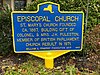 | 2017 | 315 Lake Shore Road | Lake Ronkonkoma, New York | EPISCOPAL CHURCH. ST. MARY’S CHURCH FOUNDED. CA. 1867. BUILDING GIFT OF COLONEL & MRS. J.H. PULESTON, MEMBER OF BRITISH PARLIAMENT. CHURCH REBUILT IN 1971. Lake Ronkonkoma Heritage Association / Purchased with a Grant from William G. Pomeroy Foundation |
| 5 | INDIAN PRINCESS |  | 2016 | Lake Shore Road, north of Portion Road and Shorehaven Boulevard | Lake Ronkonkoma, New York | INDIAN PRINCESS OF LAKE RONKONKOMA. LEGEND SAYS SHE CLAIMS ONE MALE EACH YEAR BY DROWNING TO BE WITH HER AT BOTTOM OF LAKE AS SHE SEEKS HER TRUE LOVE. Lake Ronkonkoma Heritage Association / NEW YORK FOLKLORE SOCIETY/ Purchased with a Grant from William G. Pomeroy Foundation |
| 6 | ARROWHEADS |  | 2017 | Cherry Street | Lake Ronkonkoma, New York | ARROWHEADS. E. Basford Hawkins And Ivar Okvist Collected Over 5000 Arrowheads & Artifacts In Lake Ronk. 1893-1988. Rest Well Gentlemen. Lake Ronkonkoma Heritage Association |
| 7 | 1853 SITE OF | 2017 | Hawkins Avenue | Lake Ronkonkoma, New York | 1853 SITE OF Methodist Episcopal CHurch. Dedicated April 1853. Incorporated 1859. Congregation Established In 1780 Home of Caleb Newton. Lake Ronkonkoma Heritage Association | |
| 1 | Brentwood, New York |  | 2013 | 1769 Brentwood Rd, Brentwood, NY 11717 | Brentwood, New York | Modern Times octagon home designed for economy of space by William Upham Dame. Residence 1st fl. & M.T. assembly hall on 2nd fl.. Historical Landmark Preservation Committee |
| 1 | BALD HILL | 2013 | Farmingville Hills Park | Farmingville, New York | One-Room Greek Revival style schoolhouse built in 1850. This school served the Farmingville community continuously until 1929. William C. Pomeroy Foundation | |
| 2 | HISTORIC FLIGHT |  | Artist Lake, NY 25 | Middle Island, New York | Ralph Johnstone landed near here on October 27, 1910, after wind forced his plane backwards from Belmont Park Altitude record of 8471 ft. Town of Brookhaven | |
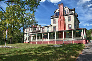
| 3 | MORICHES INN |  | 2013 | 81 Main Street | Center Moriches, New York | AKA Terry-Ketcham Inn. In 1791 Thomas Jefferson & James Madison lodged here while on a trip to visit General Wm. Floyd of Mastic. William C. Pomeroy Foundation |
| 3 | HART'S TAVERN |  | 1999 | 261 Montauk Highway | Patchogue, New York | In 1790 George Washington lodged here while on a trip to tour Long Island. The Greater Patchogue Historical Society 1999 |
| 4 | NEAR THIS SITE |  | 2013 | New York State Route 25A across from Patchogue Drive | Rocky Point, New York | Freed African-Americans owned and developed land by 1790. Davis, Jessup, Lyman, Sells, Phillips, Prince, and Miller families among early settlers. William G. Pomeroy Foundation |
| 5 | POOSPATUCK RES. |  | 2015 | Montauk Highway | Mastic, New York | Unkechaug Indian Nation recognized by State of New York 1777. Located 1 mile south at Forge River and Poospatuck Creek William G. Pomeroy Foundation |
| 6 | ROE TAVERN |  | 1936 | New York State Route 25A | East Setauket, New York | Stood here 1703–1936. Washington spent the night here April 22, 1790. Austin Roe, Inn Keeper, was one of Washington's spies. State Education Department |
| 7 | CIRCA 1740 |  | Montauk Highway | South Haven, New York | South Haven Church Cemetery (Presbyterian). Burial Ground of early settlers of Brookhaven and their descendants. Church moved to Brookhaven Hamlet 1961. New York Commission of the Bicentennial U. S. Constitution | |
East Hampton
| Marker name | Image | Date designated | Location | City or Town | Marker text | |
|---|---|---|---|---|---|---|
| 1 | East Hampton Town | 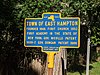 | 1975 | 732 E Hampton Sag Harbor turnpike, New York State Route 114 | Village of East Hampton, New York | Founded 1648, Dongan Patent 1686 State Education Dept. 1937 |
| 2 | Clinton Academy | 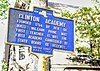 | 1975 | 151 Main Street | Village of East Hampton, New York | Founded 1784 by Rev. Dr. Buell. William Payne was first teacher. It was the first Academy Chartered by State Board of Regents. Suffolk County A.R.B.C. 1975 |
| 3 | May Groot Manson - Suffragette | 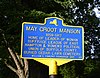 | 2017 | 117 Main St, East Hampton, NY 11937 New York State Route 27 | Village of East Hampton, New York | Inscription. MAY GROOT MANSON 1859-1917. HOME OF LEADER OF WOMAN SUFFRAGE LEAGUE OF EAST HAMPTON & WOMEN'S POLITICAL UNION William G. Pomeroy Foundation. 2017 |
| 4 | Site of Home REV. THOMAS PAYNE |  | 1975 | 38 James Lane, opposite South Hill Cemetery | Village of East Hampton, New York | Lived here 1650-96. Prepared a Catechism for Montauk Indians. Was arrested for asserting rights. Suffolk County A.R.B.C. 1975 |
| 5 | First Sheep Fold | 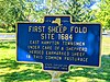 | 1950 | 3 Egypt Lane, Pantigo | Town of East Hampton, New York | First Sheep Fold pasture. c.1684. “very swampy, wet area” that was the first sheep pasture in East Hampton’s history, next to The Hiram Sanford House, restored house of the man who ran the Pantigo Windmill State Education Department 1950 |
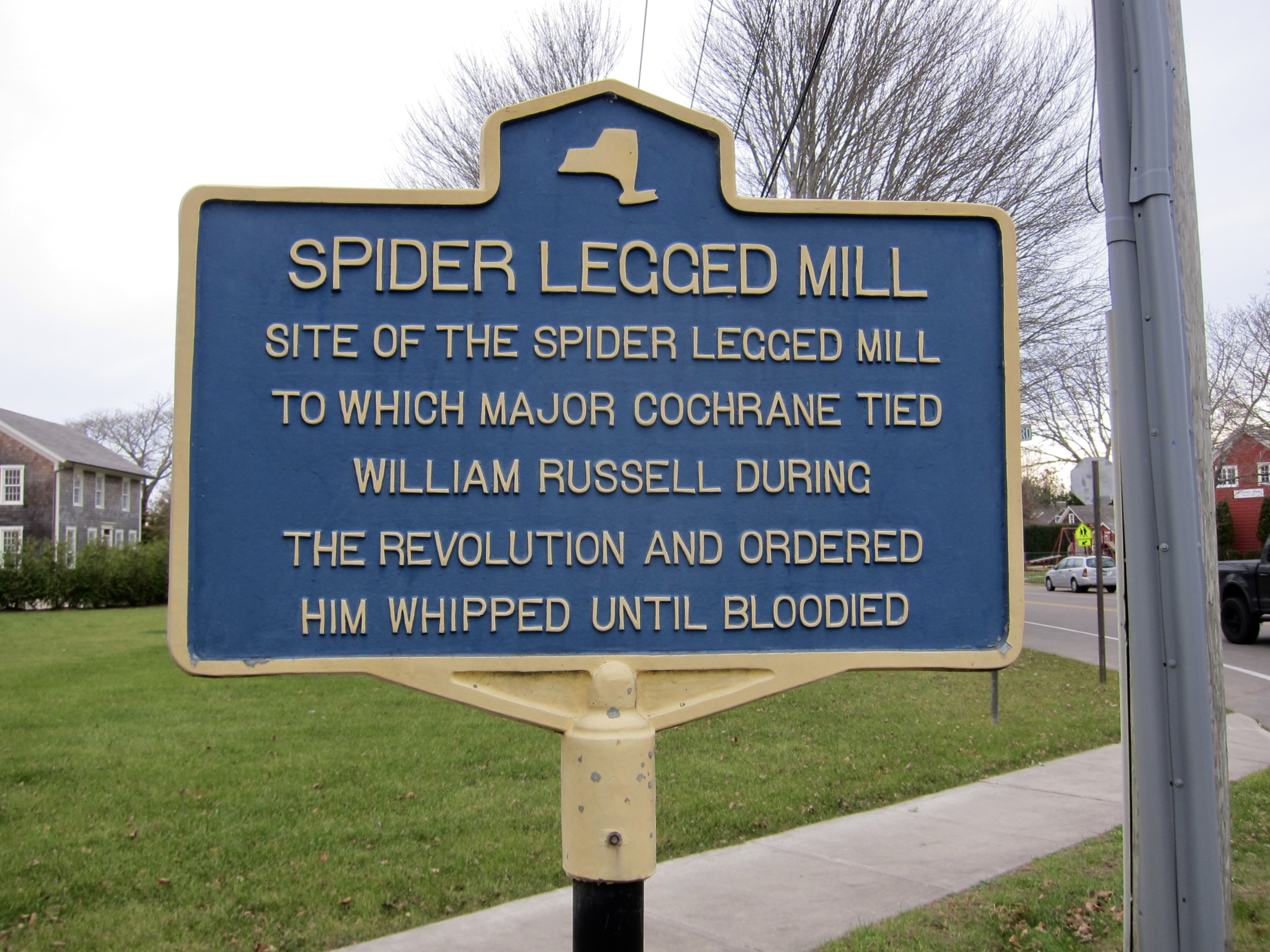
| 6 | Spider Legged Mill |  [2] [2] | 1950 | 400 Sagg Main Street, Sagaponack, NY 11962 | Town of East Hampton, New York | Inscription: Site of the Spider Legged Mill to which Major Cochrane tied William Russell to a post during the Revolution and ordered him whipped until bloodied [3] State Education Department 1950 |
| 7 | Poxabogue Mill | 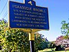 [4] [4] | 1950 | 54 Sagg Main Street, Sagaponack, NY 11962 | Town of East Hampton, New York | Inscription: Site of a spider legged mill. Subject of a famous lawsuit which decided the rights of landowners to adjacent highway New York State law 1842 [3] State Education Department 1950 |
| 8 | Town Church |  | 1935 | 158 Main St, East Hampton, NY 11937 | Village of East Hampton, New York | Inscription: Largest and most costly on Long Island. Used 1717-1861. Here were ordained Samuel Buel, Samson Occom, Lyman Beecher and Stephen Mershon State Education Department 1935 |
| 9 | Town Church site | 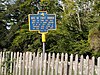 | 1975 | 39 James Lane, South Hill Cemetery | Village of East Hampton, New York | Site of the first town church. Built by town 1651. Used until 1717. A frame building 20x26 with a thached roof, stood on or very near this spot ARBC 1975 |
| 10 | First Custom House | 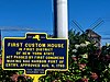 | 1936 | 3 Main St, Sag Harbor, NY 11963 | Town of East Hampton, New York | First Custom House in the First District of New York State - Act passed by Congress making Sag Harbor Port of Entry, approved Aug.4,1790 State Education Department 1936 |
Huntington
| Marker name [1] | Image | Date designated | Location | City or Town | Marker text | |
|---|---|---|---|---|---|---|
| 1 | Arthur Dove (1880–1946) Helen Torr (1886–1967) |  | 2016 | 30 Centershore Road | Centerport, New York | Early Abstract Artists Lived and Painted Here Beginning in 1938 Heckscher Museum |
| 2 | Bethel A.M.E. Church |  | 1986 | 291 Park Avenue | Huntington, New York | Incorporated in 1843, Moved in 1845 to the building called "The Seminary" standing here at that time Historian's Office, 1986 |
| 3 | Brindley Field | 1974 | Northeast corner of Larkfield Road and Jericho Turnpike | Commack, New York | World War 1, U.S. Army Signal Corps, aviation section, flying training field, June 1918 – May 1919 Town of Huntington | |
| 4 | Camp Alvernia |  | 2003 | On Prospect Road | Centerport, New York | Established 1888, First Catholic Summer Camp in the Country. Legendary Coach Vince Lombardi Practiced Football Here with St. Francis Prep 1932 & 33. - Franciscan Brothers Town of Huntington |
| 5 | CARLL HOUSE |  | 2002 | 49 Melville Road @ Eckert Street | South Huntington, New York | This is the only example of early hewn salt box architecture on Long Island. Built around 1740. Town of Huntington |
| 6 | Clay Pitts Road | 1999 | East Northport, New York | Road also called \"Water St.\" for river which once ran here. Later called \"Avery Road\" for early local farmer. East Northport Chamber of Commerce | ||
| 7 | COLD SPRING HARBOR FIRE DEPARTMENT | 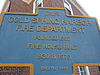 | 1993 | Main Street at Elm Place | Cold Spring Harbor, New York | Founded 1852. Fire House Built 1930 & 1970. Town of Huntington |
| 8 | Constitution Oak |  | 1988 | Old Town Green | Huntington, New York | Dedicated on the 200th anniversary of New York States Ratification of the U.S. Constitution. Town of Huntington |
| 9 | CROSS ISLAND TROLLEY 1898-1927 | 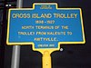 | 1990 | Halesite Fire Department on NY 110 | Halesite, New York | North Terminus of the Trolley from Halesite to Amityville. Town of Huntington |
| 10 | EATON'S NECK |  | 1964 | Eatons Neck Road, west of Ocean Avenue | Northport, New York | Home of John Sloss Hobart. Revolutionary War Patriot, U.S. Senator & Judge. He mortgaged all but honor to found this nation. Northport High School |
| 11 | FIRE DEPARTMENT |  | 1993 | 237 Main Street | Huntington, New York | This building housed the first motorized fire engines on L.I. and was the site of the Huntington Fire Department from 1911 to 1958. Town of Huntington |
| 12 | FIVE GATES | 2003 | 627 Half Hollow Hills Road | Half Hollow Hills, New York | Built by John Rogers in 1732. Oldest House in Dix Hills. Name refers to number of gates to grazing areas. Nat'l Reg. Historic Places Town of Huntington | |
| 13 | Huntington's Earliest CHURCH |  | 1965 | SW corner of New York State Route 25A and Spring Street | Huntington, New York | Stood on this corner 1665 to 1715 when it was sold for 5 lbs. and 2 shillings. Town of Huntington |
| 14 | IN MEMORIAM | Northeast corner of Larkfield Road and Jericho Turnpike | Commack, New York | On August 16, 1918, an aircraft accident at this site claimed the lives of 2nd lts. C.S. Gideon & Harold Maxson stationed at Brindley Field. The Town Historian | ||
| 15 | INTERNATIONAL BOUNDARY | 1976 | Woodbury Road and Southwest Corner of Harbor Road | Cold Spring Harbor, New York | Of New Netherland and the New England Confederation by the Treaty of Hartford 1650-1664. Bicentennial Committee | |
| 16 | INTERNATIONAL BOUNDARY |  | 2004 | Manetto Hill Road east of Plainview Road | West Hills, New York | Of New Netherland and the New England Confederation by the Treaty of Hartford 1650-1664. Town of Huntington |
| 17 | J. GARDINER FARM | 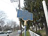 | 2006 | 900 Park Avenue | Greenlawn, New York | House Built 1750. Enlarged 1860. Site of gruesome murder in 1842. Bequeathed to H. Gardiner in 2003 to the Greenlawn - Centerport Historical Association Town of Huntington |
| 18 | ISRAEL KETCHUM | 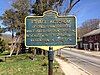 | 1985 | Harbor Road, west of Shore Road | Cold Spring Harbor, New York | Of Cold Spring Harbor while jailed for counterfeiting revealed a plot to assassinate George Washington in June 1776. Town of Huntington, Erected 1985 |
| 19 | JOSEPH LLOYD MANOR | 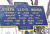 | 1976 | Lloyd Harbor Road and Lloyds Lane | Lloyd Harbor, New York | Interior by Connecticut Housewrights in 1766–67 for Joseph Lloyd 1716–1780, Patriot, Son of Henry Lloyd 1st Lord of the Manor Town of Huntington Bicentennial Commission |
| 20 | L. I. MOTOR PARKWAY | 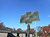 | 1973 | Half Hollow Hills Community Library | Half Hollow Hills, New York | First concrete limited-access highway built by W.K. Vanderbilt; A. Pardington, Engineer 1908–1910 Town of Huntington |
| 21 | L. I. MOTOR PARKWAY |  | 2004 | Lloyd Harbor Road and Lloyds Lane | Melville, New York | Remains of last parkway bridge in Suffolk Co., 125' east constructed 1910 for passage over 1st limited access highway preserved in 2004 Town of Huntington / Oxford Management Services |
| 22 | LLOYD MANOR |  | 1993 | Lloyd Harbor Road | Lloyd Harbor, New York | Built by Henry Lloyd in 1711. Birthplace of Jupiter Hammon, America's First Black Poet, October 17, 1711-Ca. 1790 Town of Huntington |
| 23 | MASONIC LODGE | 342 New York Avenue | Huntington, New York | Chartered on January 25, 1860. Land purchased 1869 for $1000. Cornerstone laid August 25, 1904. First meeting at this location held March 27, 1905 Jephtha Lodge No. 494 F.&A.M. | ||
| 24 | NORTHPORT RAILROAD STATION |  | 2000 | Parking Lot 33 between entrance and exit to Bellerose Avenue | East Northport, New York | Original station was 1½ miles northwest which remained open from 1867–1899. This station opened 1873-Also called Northport. In Memory of Frank C. Becher.; East Northport Chamber of Commerce. |
| 25 | OLD COUNTRY ROAD | 2000 | Melville, New York | Samuel Ketcham's hollow southern boundary of the first purchase from the Maitencock Indians in 1653 New York State Bicentennial Commission, 1976 and the Town of Huntington. | ||
| 26 | SILAS WOOD | 1936 | Huntington, New York | 1769–1847, Author of first history of Long Island, his home stood on this site until 1881. New York State Educational Department, 1936 and the Town of Huntington. | ||
| 27 | Site Of CENTERPORT (UPPER) MILL |  | 1977 | Northeast corner of Mill Dam Road and Centershore Road | Centerport, New York | Built by Sylvanus Townsend in 1774, replaced an earlier mill build further south in 1674. New York State Bicentennial Commission, 1977 and the Town of Huntington. |
| 28 | SITE OF ST. JOHN'S EPISCOPAL CHURCH AND BURIAL GROUND |  | 1989 | At Bethel AME Church and Manse | Huntington, New York | Built 1747. Samuel Seabury, Jr., Catechist, 1784 & Later. First American Bishop, 1784. Town of Huntington. |
| 29 | SKIDMORE HOUSE | 1977 | Northport, New York | Oldest House in Village of Northport. Built by Bryant Skidmore in 1761 near Great Cow Harbor and Red Hook. New York State Bicentennial Commission, 1977 and the Town of Huntington. | ||
| 30 | SUFFOLK COUNTY |  | 1937 | NY 25A, east of Nassau-Suffolk County Line | Cold Spring Harbor, New York | Organized Nov. 1, 1683. One of Original counties of New York. Originally East Riding of Yorkshire. New York State Education Department, 1937. |
Islip
| Marker name | Image | Date designated | Location | City or Town | Marker text | |
|---|---|---|---|---|---|---|
| 1 | 1859 Dame House [5] | | Third Avenue and Fourth Street | Brentwood | Modern Times Octagon Home. Designed for economy of space by William Upham Dame. Residence 1st Floor & M.T. Assembly Hall on 2nd Floor Historic Landmark Preservation Committee | |
| 2 | Gibb Patent |  | Main Street at Islip Town Hall | Islip | Islip Hamlet Land Grant by British Rulers William and Mary to Andrew Gibb in 1692. Associate of William Nichol and Leisler Rebellion Foe. Historical Society of Islip Hamlet | |
| 3 | ISLIP DEPOT |  | Islip Avenue at Parking Field 9 | Islip | South Side Railroad 1867–1876. LIRR acquired 1880. 2nd Track 1908. Station house south side 1868–1950. North 1959. Restored 1997. Historical Society of Islip Hamlet | |
| 4 | L.I. MOTOR PARKWAY 1908-1938 [6] |  | 2017 | Lakeland Fire Department on Long Island Motor Parkway | Ronkonkoma | Early Road Built Exclusively for Automobiles Eastern Terminus Completed in 1911 to Ronkonkoma Lake Lake Ronkonkoma Heritage Association / Purchased with a grant from William G. Pomeroy Foundation |
| 5 | Old '88 |  | Sayville Public Library, Greene Avenue at Swayze Street | Sayville | 1888–1969. Educated the community for Eighty-One Years. Designed by Issac H. Green, Jr. Sayville Historic Society | |
| 6 | The Green House |  | 93 Montauk Highway | West Sayville | George Washington stopped at this historic home during his historic tour of Long Island on April 21, 1790. Sayville Historic Society | |
Southold
| Marker name | Image | Date designated | Location | City or Town | Marker text | |
|---|---|---|---|---|---|---|
| 1 | First Submarine Base | 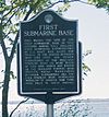 | Main Street at Cutchogue Harbor Holland Torpedo Boat Station | New Suffolk | This marks the site of the first submarine base in this country where "U.S.S. Holland" first submarine commissioned by U.S. Navy was based for trials. In the period between 1899 and 1905 six other submarines of the Holland Torpedo Boat Co. were based at this site which was known as the Holland Torpedo Boat Station. Naval maneuvers between submarines and the U.S.S. Torpedo Boat Destroyer "Winslow" of Spanish War fame were held in these waters. Cutchogue - New Suffolk Historical Society | |
| 2 | Truman's Beach |  | East Marion-Orient Causeway | East Marion | Called "Hard Beach" by the first settlers. During the War of 1812 Commodore Decatur with three ships "United States," "Macedonia" and "Hornet" lay at anchor off this sand spit. Eight times in two centuries, storms tore through here and cut Oysterponds off from the mainland. Oysterponds Historical Society | |
Smithtown
| Marker name | Image | Date designated | Location | City or Town | Marker text | |
|---|---|---|---|---|---|---|
| 1 | BATTLE OF FORT SLONGO | 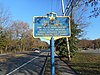 | Fort Salonga Road east of Bread and Cheese Hollow Road | Fort Salonga | Took place near this site on Oct. 3, 1781. American forced defeated British forces holding Fort Slongo Donated by Fort Salonga Association | |
| 2 | HOME OF OBADIAH SMITH | 853 Saint Johnland Road | San Remo | Circa 1700 - Grandson of the Patentee Richard Smythe | ||
| 3 | NISSEQUOGUE SCHOOL | 631 Moriches Road (now the Village Hall) | Saint James | Built 1808 - Subscribers; James Smith. Ebenezer Smith. Thomas Smith. Richard Smith. Peter Jayne. Woodhull Smith. Micah Smith. Nicholas Smith. | ||


