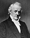
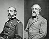
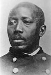
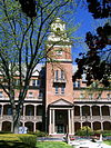
Marker title Image Date dedicated Location Marker type Topics 54th Mass. Infantry Regiment, US Colored Troops (The) November 7, 2009 Zion Union Cemetery, Bennette Ave., Mercersburg 39°49′13″N 77°54′20″W / 39.82031°N 77.90564°W / 39.82031; -77.90564 (54th Mass. Infantry Regiment, US Colored Troops, The ) Roadside African American, Civil War, Military Brown's Mill School April 20, 1966 At site - off Rt. 11 via Kaufman Rd., at Angle & Brown's Mill Rds., SE of Marion 39°49′51″N 77°42′07″W / 39.8307°N 77.702°W / 39.8307; -77.702 (Brown's Mill School ) Roadside Buildings, Education Buchanan House July 2, 1953 17 N Main St., Mercersburg 39°49′44″N 77°05′47″W / 39.8288°N 77.0963°W / 39.8288; -77.0963 (Buchanan House ) City Exploration, Government & Politics, Government & Politics 19th Century, Professions & Vocations Burning of Chambersburg December 5, 1947 SE corner of square at Rts. 30 & 11, Chambersburg 39°56′15″N 76°20′20″W / 39.9375°N 76.3389°W / 39.9375; -76.3389 (Burning of Chambersburg ) Roadside Civil War, Military Burning of Chambersburg December 5, 1947 Pa. 416, 200 yards N of state line 39°43′20″N 76°11′47″W / 39.7222°N 76.1963°W / 39.7222; -76.1963 (Burning of Chambersburg ) Roadside Civil War, Military Caledonia Furnace August 25, 1947 US 30 & PA 233, Caledonia State Park, east end of Fayetteville Roadside African American, Business & Industry, Civil War, Furnaces, Military Captain Ulric Dahlgren June 1, 1954 SE section of Square, Greencastle 39°47′24″N 77°43′39″W / 39.79°N 77.7275°W / 39.79; -77.7275 (Captain Ulric Dahlgren ) City Civil War, Military Chambersburg 1948 U.S. 11, .3 mile S of borough line Roadside Cities & Towns, Civil War, Early Settlement, Government & Politics Chambersburg n/a US 11 & Roland Ave., 1.5 miles N of Chambersburg, near borough line 39°57′21″N 77°38′42″W / 39.9559°N 77.64507°W / 39.9559; -77.64507 (Chambersburg ) Roadside Cities & Towns, Civil War, Early Settlement, Government & Politics Chambersburg 1948 US 30 W end of Chambersburg Roadside Cities & Towns, Civil War, Early Settlement, Government & Politics Chambersburg n/a US 30 at I-81, west side of intersection, E end of Chambersburg 39°55′46″N 76°21′47″W / 39.9294°N 76.3631°W / 39.9294; -76.3631 (Chambersburg ) Roadside Cities & Towns, Civil War, Government & Politics Confederate Conference August 10, 1953 SW quadrant of public square, Chambersburg 39°56′14″N 76°20′18″W / 39.9372°N 76.3384°W / 39.9372; -76.3384 (Confederate Conference ) City Civil War, Military Dr. Henry Harbaugh December 5, 1947 14301 Harbaugh Church Rd., (@ church), off Midvale Rd. south of Midvale 39°43′17″N 76°27′59″W / 39.7214°N 76.4664°W / 39.7214; -76.4664 (Dr. Henry Harbaugh ) Roadside Education, Ethnic & Immigration, Professions & Vocations, Religion Falling Spring Church May 10, 1948 US 11 at church, 2 blocks N of Square, Chambersburg City Buildings, Ethnic & Immigration, Religion First Lutheran Church August 10, 1953 W. Washington St. at church (near Black St.), Chambersburg 39°56′04″N 76°20′12″W / 39.9344°N 76.3366°W / 39.9344; -76.3366 (First Lutheran Church ) City Buildings, Religion Fort Chambers June 3, 1947 W. King St., 1 block W of US 11, Chambersburg 39°56′21″N 76°20′16″W / 39.9391°N 76.3378°W / 39.9391; -76.3378 (Fort Chambers ) City Early Settlement, Forts, French & Indian War, Military, Mills, Native American Fort Davis October 29, 1946 PA 995 & Bain Rd. (near Church of Brethren at Welsh Run) 39°45′34″N 77°51′45″W / 39.75952°N 77.86262°W / 39.75952; -77.86262 (Fort Davis ) Roadside Forts, French & Indian War, Military Fort Davis - PLAQUE June 1, 1931 on private farm, W side of Bain Rd., 1.3 mi. S of PA 995 at Welsh Run 39°44′38″N 76°07′26″W / 39.744°N 76.1239°W / 39.744; -76.1239 (Fort Davis - PLAQUE ) Plaque Forts, French & Indian War, Government & Politics 18th Century, Military Fort Loudon May 27, 1947 US 30 & Brooklyn Rd., ~1 mile E of Fort Loudon (Missing) 39°54′23″N 76°07′08″W / 39.9063°N 76.119°W / 39.9063; -76.119 (Fort Loudon ) Roadside Forts, French & Indian War, Military Fort Loudon - PLAQUE October 1, 1915 US 30 (Old Lincoln Hwy.), in center of Fort Loudon 39°54′53″N 76°05′42″W / 39.9148°N 76.0951°W / 39.9148; -76.0951 (Fort Loudon - PLAQUE ) Plaque Forts, French & Indian War, Military Fort Marshall 1946 Valley Rd. & Shimpstown Rd., S of Mercersburg Roadside Forts, French & Indian War, Military Fort McCord August 8, 1947 ~2.5 miles NE of Edenville on SR 4008 at Rumler Rd. 39°59′10″N 76°13′40″W / 39.986°N 76.2277°W / 39.986; -76.2277 (Fort McCord ) Roadside Forts, French & Indian War, Military, Native American Fort McCord - PLAQUE October 1, 1914 ~2.5 mi. NE of Edenville up SR 4008 to Rumler Rd., ~.5 mi. south to barn, plaque within fence on left 39°59′06″N 76°13′36″W / 39.985°N 76.2266°W / 39.985; -76.2266 (Fort McCord - PLAQUE ) Plaque Early Settlement, Forts, French & Indian War, Military, Native American Fort McDowell September 10, 1947 Pa. 416 at Markes, junction of Mercersburg & Lamar Rds. 39°52′29″N 76°07′42″W / 39.8747°N 76.1284°W / 39.8747; -76.1284 (Fort McDowell ) Roadside Forts, French & Indian War, Military, Mills Fort McDowell - PLAQUE October 1, 1916 PA 416 at Markes, junction of Mercersburg & Lamar Rds. 39°52′29″N 76°07′42″W / 39.8747°N 76.1284°W / 39.8747; -76.1284 (Fort McDowell - PLAQUE ) Plaque Forts, French & Indian War, Military, Mills, Roads Fort Waddell May 27, 1947 U.S. 30, near junction Pa. 416, 1 mile W of St. Thomas (MISSING) 39°57′40″N 76°10′45″W / 39.9612°N 76.1793°W / 39.9612; -76.1793 (Fort Waddell ) Roadside Early Settlement, Forts, French & Indian War, Military, Native American Fort Waddell (1754) - PLAQUE n/a Route 30, W of Chambersburg, near PA416 junction, 1 mi W of St. Thomas (N side) 39°54′40″N 76°10′46″W / 39.9112°N 76.1795°W / 39.9112; -76.1795 (Fort Waddell 1754 - PLAQUE ) Plaque Forts, French & Indian War, Military Franklin County May 15, 1982 County Courthouse, Memorial Square (N. Main St.), corner of U.S. 11 & 30, Chambersburg 39°56′15″N 76°20′20″W / 39.9376°N 76.3389°W / 39.9376; -76.3389 (Franklin County ) City Cities & Towns, Government & Politics, Government & Politics 18th Century Frederick Douglass and John Brown August 21, 1994 West Washington St., behind Southgate Mall, Chambersburg 39°56′05″N 77°40′00″W / 39.93476°N 77.66664°W / 39.93476; -77.66664 (Frederick Douglass and John Brown ) Roadside African American, Government & Politics 19th Century, Military George H. Wirt (1880 - 1961) October 1, 2005 near PSU Mont Alto campus, approx. 120 yds. E of Slabtown Rd. on south side of PA 233 Roadside Environment, Government & Politics 20th Century Gettysburg Campaign November 2, 1964 PA 16 at Roadside Ave., E of square in Waynesboro 39°45′06″N 76°25′47″W / 39.7516°N 76.4296°W / 39.7516; -76.4296 (Gettysburg Campaign ) Roadside Civil War, Military Gettysburg Campaign November 2, 1964 US 11, just N of Greencastle 39°48′15″N 76°16′39″W / 39.8041°N 76.2775°W / 39.8041; -76.2775 (Gettysburg Campaign ) Roadside Civil War, Military Gettysburg Campaign December 5, 1997 US 11, 1 mile N of State Line 39°43′56″N 76°16′30″W / 39.7321°N 76.2751°W / 39.7321; -76.2751 (Gettysburg Campaign ) Roadside Civil War, Military Gettysburg Campaign January 10, 1948 US 30E near intersection w/ Willowbrook Dr., just E of Chambersburg, ~.5 mi past I81 (at veterinary clinic) 39°55′36″N 76°22′24″W / 39.9268°N 76.3734°W / 39.9268; -76.3734 (Gettysburg Campaign ) Roadside Civil War, Military Gettysburg Campaign December 5, 1947 US 11 near Roland Ave., 1.5 mi. N of Chambersburg 39°57′25″N 76°21′21″W / 39.9569°N 76.3557°W / 39.9569; -76.3557 (Gettysburg Campaign ) Roadside Civil War, Military Gettysburg Campaign December 5, 1947 US 11 at Kriner, at Trickling Spgs. Creamery, S of Chambersburg 39°54′17″N 77°40′20″W / 39.90486°N 77.67223°W / 39.90486; -77.67223 (Gettysburg Campaign ) Roadside Civil War, Military Israel Benevolent Society Cemetery May 12, 2002 361 East Washington Street, Chambersburg 39°56′01″N 76°20′39″W / 39.9336°N 76.3441°W / 39.9336; -76.3441 (Israel Benevolent Society Cemetery ) Roadside Civil War, Military, Religion Jacob Nelson "Nellie" Fox August 3, 2001 7417 Lincoln Hwy. (US 30), at Schoolhouse Road (square), St. Thomas 39°55′03″N 76°12′06″W / 39.9174°N 76.2016°W / 39.9174; -76.2016 (Jacob Nelson "Nellie" Fox ) City Baseball, Sports James Buchanan January 1, 1955 PA 16W, @ fork of Stoney Batter & Buchanan Sts., at Buchanan State Park entrance, Cove Gap 39°51′59″N 76°03′19″W / 39.8665°N 76.0553°W / 39.8665; -76.0553 (James Buchanan ) Roadside Buildings, Education, Government & Politics, Government & Politics 18th Century John Brown n/a 225 E. King St., Chambersburg 39°56′20″N 77°39′30″W / 39.93881°N 77.65831°W / 39.93881; -77.65831 (John Brown ) City African American, Government & Politics 19th Century, Military John Brown Raid June 11, 1947 PA 233, 1 mile E of Mont Alto, across from PSU campus 39°50′25″N 76°27′19″W / 39.8404°N 76.4553°W / 39.8404; -76.4553 (John Brown Raid ) Roadside African American, Government & Politics 19th Century, Military John Wallace Jr. June 27, 1955 E. Main & Enterprise Sts., Waynesboro 39°45′04″N 76°25′54″W / 39.751°N 76.4317°W / 39.751; -76.4317 (John Wallace Jr. ) City Professions & Vocations Joseph G. Armstrong May 14, 1960 SR 4010 at Coble Rd. near Edenville 39°57′47″N 76°12′50″W / 39.9631°N 76.2139°W / 39.9631; -76.2139 (Joseph Armstrong ) Roadside Early Settlement, French & Indian War, Government & Politics 18th Century, Military, Native American Joseph Winters May 23, 2005 Junior Hose and Truck Company #2, 130 N Second St., Chambersburg City African American, Entrepreneurs, Invention, Native American, Police and Safety, Underground Railroad Lane House July 2, 1953 16 N. Main St., Mercersburg 39°49′43″N 76°05′46″W / 39.8287°N 76.0962°W / 39.8287; -76.0962 (Lane House ) City Government & Politics, Government & Politics 19th Century Margaret Cochran Corbin October 1, 1961 US 11 near Roand Ave., 1.5 miles N of Chambersburg 39°57′26″N 76°21′22″W / 39.9572°N 76.356°W / 39.9572; -76.356 (Margaret Cochran Corbin ) Roadside American Revolution, Military, Women Marshall College May 1, 1953 PA 16 at entrance to Mercersburg Academy, Mercersburg 39°49′42″N 76°06′02″W / 39.8283°N 76.1005°W / 39.8283; -76.1005 (Marshall College ) Roadside Education, Religion Martin Delany (1812-1885) October 25, 2003 566 S. Main St., Chambersburg Roadside African American, Civil Rights, Military, Professions & Vocations, Publishing, Underground Railroad Masonic Temple November 30, 1964 S. 2nd St. near E. Queen St., Chambersburg 39°56′09″N 76°20′26″W / 39.9359°N 76.3406°W / 39.9359; -76.3406 (Masonic Temple ) City Buildings, Civil War, Military Masonic Temple November 30, 1964 S 2nd St. (northbound) near E. Queen St., Chambersburg (Missing) City Religion Messersmith's Wood August 20, 1973 Lincoln Hwy. (US 30) near Colbrook Ave., Chambersburg 39°55′54″N 76°21′20″W / 39.9318°N 76.3555°W / 39.9318; -76.3555 (Messersmith's Wood ) City Civil War, Military Morrow Tavern August 1, 1953 37 S. Main St., Chambersburg 39°56′12″N 76°20′19″W / 39.9368°N 76.3385°W / 39.9368; -76.3385 (Morrow Tavern ) City Buildings, Business & Industry, George Washington, Military, Inns & Taverns, Whiskey Rebellion Old Franklin County Jail May 9, 1975 N. 2nd St. at E. King St. (US 11), Chambersburg 39°56′20″N 76°20′28″W / 39.939°N 76.341°W / 39.939; -76.341 (Old Franklin County Jail ) Roadside Government & Politics, Government & Politics 19th Century Old Log Building June 27, 1955 E. Main St. & Roadside Ave., Waynesboro 39°45′07″N 76°25′46″W / 39.752°N 76.4294°W / 39.752; -76.4294 (Old Log Building ) City Buildings, Education Patrick Gass (1771-1870) January 13, 2004 181 Franklin Farm Lane, Chambersburg, off Rt. 30 at Sheetz Roadside Environment, Exploration, Military, War of 1812 Pennsylvania January 1, 1949 US 11 at Mason Dixon Rd., Middleburg, near MD state line Roadside Early Settlement, Government & Politics 17th Century, William Penn Pennsylvania State Forest Academy May 13, 2003 just off Park St. (Rt. 233) on Campus Dr., at entrance of PSU, Mont Alto Roadside Education, Environment, Government & Politics 20th Century Philip Berlin August 10, 1953 W. Washington St. & Black Ave. at Lutheran Church, Chambersburg 39°56′04″N 76°20′13″W / 39.9345°N 76.3369°W / 39.9345; -76.3369 (Philip Berlin ) City Invention, Professions & Vocations, Railroads, Transportation Ralph Elwood Brock October 24, 2003 Park St. (Rt. 233) at Slabtown Rd., entrance to PSU, Mont Alto Roadside African American, Education, Environment, Professions & Vocations Reformed Theological Seminary May 1, 1953 PA 16 at entrance to Mercersburg Academy, Mercersburg 39°49′42″N 76°06′02″W / 39.8284°N 76.1006°W / 39.8284; -76.1006 (Reformed Theological Seminary ) Roadside Education, Religion Rev. Steel's Fort June 3, 1947 Buchanan Trail (PA 16) at Findley Rd., 2.3 miles SE of Mercersburg 39°48′14″N 76°07′49″W / 39.804°N 76.1302°W / 39.804; -76.1302 (Rev. Steel's Fort ) Roadside French & Indian War, Military, Native American Shippensburg June 1, 1948 W King St. (US 11) at Park Heights Ave., W end of Shippensburg 40°02′33″N 76°27′53″W / 40.0425°N 76.4648°W / 40.0425; -76.4648 (Shippensburg ) Roadside Cities & Towns Snow Hill Cloister December 21, 1966 PA 997 just S of Quincy 39°47′23″N 76°25′30″W / 39.7898°N 76.425°W / 39.7898; -76.425 (Snow Hill Cloister ) Roadside Religion Stuart's Raid December 5, 1947 Blair's Valley Rd., about 100 yds. N of state line Roadside Civil War, Military Suesserott House May 1, 1969 SW corner of Main & Washington Sts., Chambersburg 39°56′03″N 76°20′16″W / 39.9342°N 76.3377°W / 39.9342; -76.3377 (Suesserott House ) City Buildings, Civil War, Houses & Homesteads, Military, Professions & Vocations Thompson's Rifle Battalion: Capt. James Chambers' Company July 28, 1991 W King St., 1 block W of US 11, in Ft. Chambers Park, Chambersburg 39°56′20″N 76°20′16″W / 39.9388°N 76.3377°W / 39.9388; -76.3377 (Thompson's Rifle Battalion: Capt. James Chambers' Company ) Roadside American Revolution, Military Underground Railroad Activity in Chambersburg January 15, 2003 Main St. & Lincoln Hwy. (Rt. 30), on NE quadrant of the "diamond," Chambersburg Roadside African American, Underground Railroad Widow Barr Place June 20, 1955 PA 75, 1.4 miles S of Fort Loudon (Missing) 39°53′40″N 76°06′08″W / 39.8944°N 76.1023°W / 39.8944; -76.1023 (Widow Barr Place ) Roadside American Revolution, Buildings, Early Settlement, Native American William Findlay April 1, 1950 N. Main St. at Mill Rd., Mercersburg 39°49′49″N 76°05′46″W / 39.8303°N 76.096°W / 39.8303; -76.096 (William Findlay ) City Government & Politics, Government & Politics 18th Century, Governors Wilson College October 10, 1952 Edgar Ave. near Ramsey Ave., off US 11 at campus, Chambersburg 39°57′00″N 76°21′05″W / 39.9499°N 76.3515°W / 39.9499; -76.3515 (Wilson College ) Roadside Education, Women