This page documents all tornadoes confirmed by various weather forecast offices of the National Weather Service in the United States in August, and September 2024. Tornado counts are considered preliminary until final publication in the database of the National Centers for Environmental Information. [1]
Similar to July, the northern states nearer the Canadian border are most favored for tornadoes in August, including the Upper Midwest, the Great Lakes, and the Northeastern states, due to the positioning of the summertime jet stream. In addition, there can also be occasional increases in the southern and eastern United States as a result of tornadoes from landfalling tropical cyclones should such occur. [2] On average, there are 81 confirmed tornadoes in August. [3] In September, tornadoes are most likely to occur in relation to the Atlantic hurricane season (as September is the peak month of hurricane season), and they can occur almost anywhere in the southern and eastern states as a result of landfalling tropical cyclones should such occur. A secondary focal point lies in the Midwest and Great Lakes as a result of early-autumn frontal systems. On average, there are 66 confirmed tornadoes in the United States in September.
Similar to the previous month, activity during the beginning of the month was mainly due to the tropics as Hurricane Debby spawned 24 tornadoes. Simultaneous tornado activity also occurred in the Midwestern United States and Great Lakes region during that time. However, tornado activity then went dormant until the last few days of the month as non-tornadic severe storms became the norm. August ended with a slightly below average number of 70 confirmed tornadoes.
EFU | EF0 | EF1 | EF2 | EF3 | EF4 | EF5 | Total |
---|---|---|---|---|---|---|---|
10 | 20 | 35 | 4 | 1 | 0 | 0 | 70 |
EF# | Location | County / Parish | State | Start Coord. | Time (UTC) | Path length | Max width |
---|---|---|---|---|---|---|---|
EF1 | Fuquay-Varina (1st tornado) | Wake | NC | 35°35′N78°49′W / 35.59°N 78.82°W | 21:28–21:31 | 0.89 mi (1.43 km) | [ to be determined ] |
A tornado initially touched down in a field on the northside of town before moving east deeper into the town. Several large trees were snapped or uprooted. The tornado then impacted a church, damaging the roof, an awning, and outdoor electrical equipment. It lifted shortly after. [4] | |||||||
EF0 | Fuquay-Varina (2nd tornado) | Wake | NC | 35°36′N78°47′W / 35.6°N 78.79°W | 21:31 | 0.1 mi (0.16 km) | [ to be determined ] |
This brief high-end EF0 tornado touched down on the eastern portion of the Fuquay-Varina High School campus. Two baseball dugouts had their roofs torn off and a small building was overturned off its foundation before lifting. [4] | |||||||
EF1 | Western Melrose to SW of New Munich | Stearns | MN | 45°41′N94°50′W / 45.69°N 94.83°W | 01:11–01:20 | 5.36 mi (8.63 km) | 1,000 yd (910 m) |
This tornado tracked through the west side of Melrose, damaging some homes and businesses. The tornado continued south of the town, striking a few farmsteads and causing minor damage before lifting. [4] [5] | |||||||
Event is associated with Hurricane Debby.
EF# | Location | County / Parish | State | Start Coord. | Time (UTC) | Path length | Max width |
---|---|---|---|---|---|---|---|
EF1 | W of Lake Butler | Union | FL | 30°00′00″N82°30′23″W / 29.9999°N 82.5064°W | 23:40 | 0.18 mi (0.29 km) | 20 yd (18 m) |
A trailer was overturned, the roof of a shed was torn off, a wooden fence was knocked down, and a few trees were snapped or uprooted. [6] | |||||||
Events in South Carolina are associated with Hurricane Debby.
EF# | Location | County / Parish | State | Start Coord. | Time (UTC) | Path length | Max width |
---|---|---|---|---|---|---|---|
EF1 | Fort Erie, ON to Buffalo, NY | Niagara (ON), Erie (NY) | ON, NY | 42°53′20″N78°55′49″W / 42.8889°N 78.9303°W | 16:40–16:51 | 3.23 mi (5.20 km) | 300 yd (270 m) |
A weak tornado began in Canada, doing weak damage to trees. The tornado then crossed the Niagara River and made landfall at LaSalle Park in Buffalo. At the park, multiple large trees were damaged on the south end of the it. The first structural damage noted was to the air conditioners on the roofs of apartments, townhouses, and other multi-story buildings. Significant loss of roofing material was also noted. Several chimneys were toppled from homes on the northern side of the downtown area. Continuing eastward, multiple trees were snapped at Johnson Park with some of their limbs being found further east. The final observed damage was two cars overturned and some minor roof damage right where the tornado lifted. [7] [8] [9] | |||||||
EF1 | SE of Sveadahl | Watonwan | MN | 44°02′N94°43′W / 44.04°N 94.72°W | 22:26–22:28 | 2.29 mi (3.69 km) | 150 yd (140 m) |
This tornado uprooted trees, damaged power poles, and caused non-continuous crop damage. [4] [10] | |||||||
EF1 | SW of Smiths Mill to S of Janesville | Blue Earth, Waseca | MN | 44°08′N93°49′W / 44.13°N 93.81°W | 23:19–23:33 | 6.25 mi (10.06 km) | 150 yd (140 m) |
A garage door was blown in, an empty farm trailer was tipped over, a couple power poles were downed, and numerous trees were uprooted and snapped. [4] [10] | |||||||
EF1 | N of Otisco | Waseca | MN | 44°01′N93°30′W / 44.01°N 93.5°W | 23:58–00:00 | 1.45 mi (2.33 km) | 75 yd (69 m) |
Multiple large trees were snapped or uprooted. [4] [10] | |||||||
EF1 | NW of Emmons to SE of Twin Lakes | Freeborn | MN | 43°32′N93°32′W / 43.53°N 93.53°W | 00:50–01:06 | 6.57 mi (10.57 km) | 150 yd (140 m) |
Outbuildings were heavily damaged and a silo was lofted towards a tree line. Trees were uprooted and snapped as well. [4] [10] | |||||||
EFU | ESE of Emmons | Worth | IA | 43°29′N93°23′W / 43.48°N 93.39°W | 01:07–01:08 | 0.28 mi (0.45 km) | 20 yd (18 m) |
A brief tornado remained over open cropland. [4] | |||||||
EF0 | SSW of Renova | Mower | MN | 43°40′32″N92°49′40″W / 43.6755°N 92.8277°W | 01:18–01:20 | 1.01 mi (1.63 km) | 30 yd (27 m) |
A brief tornado stayed mostly in open farm fields and caused light damage to one farmstead. [11] | |||||||
EF0 | S of Wells to S of Baroda | Faribault | MN | 43°44′N93°44′W / 43.73°N 93.74°W | 01:28–01:42 | 4.87 mi (7.84 km) | 50 yd (46 m) |
An EF-0 tornado uprooted trees and downed large 12" diameter limbs halfway up the base. One fallen limb damaged the roof of a house. Crop damage was also observed adjacent to a home 1 mile south of Wells. [4] | |||||||
EF1 | Isle of Palms | Charleston | SC | 32°30′08″N80°17′46″W / 32.5023°N 80.2962°W | 01:33–01:37 | 0.72 mi (1.16 km) | 75 yd (69 m) |
This tornado was likely a waterspout over the Atlantic Ocean before moving onto land where it immediately caused minor damage to the roof of a house and also pulled the home's front door out of frame. The tornado continued north-northwest, damaging a few windows and snapping or uprooting some trees. Shingles were removed from portions of roofs of a few homes. The tornado lifted over the Intracoastal Waterway just to the east of the Isle of Palms Connector Bridge. [12] | |||||||
EF1 | Eastern Edisto Beach | Colleton, Charleston | SC | 32°30′08″N80°17′46″W / 32.5023°N 80.2962°W | 01:35–01:45 | 2.89 mi (4.65 km) | 300 yd (270 m) |
A waterspout moved onshore on the extreme eastern of Edisto Beach, removing roof decking, shingles, and siding to several homes. A nearby gas station also had some roof damage and air conditioning units ripped from its windows. The tornado exited town and entered Edisto Beach State Park, snapping and uprooting numerous trees in the park. The tornado exited the park and struck a small community, removing the entire roof off of at least three homes and part of the roof decking of at least one. The tornado continued northwest, dissipating over marshland. More damage likely occurred but wasn't documented as of now due to limited to survey. [13] | |||||||
EF0 | NNE of Taopi | Mower | MN | 43°37′38″N92°37′20″W / 43.6273°N 92.6221°W | 01:43–01:48 | 2.05 mi (3.30 km) | 70 yd (64 m) |
This tornado remained over open fields and was discovered via satellite imagery. [14] | |||||||
EFU | WNW of Carpenter | Worth | IA | 43°26′N93°05′W / 43.43°N 93.08°W | 01:43–01:44 | 0.12 mi (0.19 km) | 20 yd (18 m) |
This brief tornado was observed by storm spotters as it remained over open cropland. [4] | |||||||
EFU | WNW of Carpenter | Worth | IA | 43°26′N93°04′W / 43.43°N 93.06°W | 01:43–01:47 | 1.59 mi (2.56 km) | 30 yd (27 m) |
A tornado that did a loop through a farm field was observed by storm chasers. No damage occurred. [4] | |||||||
EF0 | Kiawah Island | Charleston | SC | 32°36′13″N80°04′26″W / 32.6035°N 80.074°W | 01:55–01:59 | 1.18 mi (1.90 km) | 150 yd (140 m) |
This high-end EF0 tornado was originally a waterspout over the Atlantic Ocean before moving onshore and impacting a golf course. Trees and limbs were snapped throughout the center of the golf course. The tornado continued north, uprooting and snapping some more trees before dissipating over marshland. [15] | |||||||
EF1 | Edisto Beach | Colleton | SC | 32°28′44″N80°19′51″W / 32.479°N 80.3307°W | 02:08–02:11 | 0.56 mi (0.90 km) | 100 yd (91 m) |
A second tornado struck Edisto Beach, this time in the main town area. It moved onshore, snapping and twisting some small trees and removing shingles from at least one home. The tornado then intensified, collapsing the porch of a home and significantly damaging a portion of its roof. The tornado continued northwestward through town, doing more minor damage to homes before dissipating at a golf course. [16] | |||||||
EF0 | SSW of Burr Oak | Winneshiek | IA | 43°23′N91°53′W / 43.39°N 91.89°W | 02:57–02:58 | 0.33 mi (0.53 km) | 30 yd (27 m) |
This brief tornado damaged several trees. [4] | |||||||
EF0 | NNE of Decorah | Winneshiek | IA | 43°23′N91°45′W / 43.38°N 91.75°W | 03:11–03:14 | 0.98 mi (1.58 km) | 80 yd (73 m) |
A high-end EF0 tornado that was embedded in a downburst damaged trees, crops and an outbuilding. [4] | |||||||
EF1 | S of Hanover | Allamakee | IA | 43°20′31″N91°33′24″W / 43.342°N 91.5568°W | 03:29–03:38 | 3.79 mi (6.10 km) | 50 yd (46 m) |
This tornado mainly damaged trees along its path but one home and several vehicles and outbuildings were damaged as well. [17] | |||||||
Events in South Carolina and North Carolina are associated with Hurricane Debby.
EF# | Location | County / Parish | State | Start Coord. | Time (UTC) | Path length | Max width |
---|---|---|---|---|---|---|---|
EF0 | Western Charleston | Charleston | SC | 32°48′00″N80°02′06″W / 32.8°N 80.035°W | 04:14–04:22 | 3.88 mi (6.24 km) | 200 yd (180 m) |
This tornado began just to the northwest of Citadel Mall, damaging small tree limbs. The tornado continued northwest snapping and uprooting several trees within the West Ashley district of Charleston before lifting. [18] | |||||||
EF0 | Lady's Island | Beaufort | SC | 32°26′21″N80°36′31″W / 32.4393°N 80.6085°W | 04:53–04:56 | 2.14 mi (3.44 km) | 60 yd (55 m) |
A short-lived, high-end EF0 tornado moved across marshlands on Lady's Island, inflicting damage to several trees. [19] | |||||||
EF1 | Northeastern Moncks Corner to Pinopolis | Berkeley | SC | 33°12′28″N79°58′51″W / 33.2079°N 79.9807°W | 05:53–06:00 | 3.88 mi (6.24 km) | 150 yd (140 m) |
A tornado began in the northeastern side of Moncks Corner, snapping trees in a commercial area. The windows of an Arby's were blown out and the rooftop air conditioning unit was tossed into the parking lot. The nearby Walmart also sustained minor roof fascia damage. The tornado continued northwest, uprooting several trees and a few large branches snapped. The tornado then crossed onto Lake Moultrie before landfalling into Pinopolis, causing some more tree damage before finally lifting. [20] | |||||||
EF2 | E of Marcellus to northern Three Rivers | St. Joseph | MI | 42°02′00″N85°45′42″W / 42.0333°N 85.7616°W | 12:19–12:33 | 8.46 mi (13.62 km) | 700 yd (640 m) |
This low-end EF2 tornado began on the eastern side of the Cass-St. Joseph county line. The tornado did significant damage to trees and power poles almost immediately as it was moving southeast. The tornado then caused a well-anchored manufactured home to slide off its foundation and significantly damaged nearby trees. A barn was completely destroyed and another barn had its entire roof ripped off and tossed. As the tornado reached peak intensity, another barn roof suffered significant damage to its roof, a home had its roof partially removed, and major tree damage occurred. The tornado continued to track southeast, overturning and twisting center pivots, snapping power poles, and doing minor to moderate roof damage to more homes. A well-constructed shed was moved a short distance from its foundation and part of it was thrown into a nearby river. The tornado then entered the northside of Three Rivers, causing minor damage to the roof of a warehouse before the tornado lifted. [21] | |||||||
EF1 | Northwestern Avon to Rocky River | Lorain, Cuyahoga | OH | 41°28′36″N82°03′46″W / 41.4768°N 82.0628°W | 19:41–19:56 | 11.93 mi (19.20 km) | 200 yd (180 m) |
This high-end EF1 tornado touched down on the northwest side of Avon then proceeded to Avon Lake, snapping multiple trees and lofting a trampoline from a backyard. The tornado continued eastward, snapping multiple trees and removing shingles from a roof. Sporadic tree damage occurred as the tornado entered Bay Village. Widespread tree damage continued with structures also being damaged in town. One roof was crushed by a fallen tree and a front porch was also damaged. The tornado then moved into Rocky River where a large tree fell onto two brick homes, heavily damaging both of them. The tornado dissipated just before reaching the West Branch Rocky River. [22] | |||||||
EF1 | Bay Village to Westlake | Cuyahoga | OH | 41°29′27″N81°56′29″W / 41.4909°N 81.9413°W | 19:54–19:56 | 1.75 mi (2.82 km) | 250 yd (230 m) |
This short-lived tornado caused extensive tree damage, some of which affected some structures. The tornado's path crossed the path of the simultaneous Avon – Rocky River tornado. [22] | |||||||
EF1 | Brook Park to Seven Hills to Bedford | Cuyahoga | OH | 41°23′48″N81°49′57″W / 41.3968°N 81.8325°W | 19:59–20:24 | 17 mi (27 km) | 350 yd (320 m) |
A tornado began to the east of Cleveland Hopkins International Airport where it immediately tore off a portion of a metal roof at a recreation center in Brook Park. Numerous trees landed on homes, cars, and took down power lines. A garage with metal siding collapsed and a nearby patio covering was also destroyed. Damage continued into the suburbs of Parma Heights and Parma where numerous power poles were leaning and partially down in yards and near homes. The tornado continued intermittently into Seven Hills and Independence, doing minor damage. Damage intensified again after crossing the Cuyahoga River into Valley View, where several large trees were uprooted, some of them falling onto homes. Strips of siding were torn off of many homes in this area as well. The tornado then entered Bedford where another neighborhood saw significant damage occur. Trees were downed on several homes, including one home which had a portion of its roof ripped off and damage to its chimney. A new, strongly secured shed was obliterated here as well. The tornado then weakened before lifting just after crossing east of I-480/I-271. [23] | |||||||
EF0 | SW of Longwood | Brunswick | NC | 33°58′42″N78°35′24″W / 33.9782°N 78.5899°W | 20:09–20:12 | 0.33 mi (0.53 km) | 40 yd (37 m) |
Several trees were uprooted and snapped along the driveway of a property. Minor damage occurred to fencing and a panel of roof of a nearby house as well. [24] | |||||||
EF1 | Southern Brecksville to N of Peninsula | Summit | OH | 41°16′36″N81°36′53″W / 41.2767°N 81.6146°W | 20:20–20:25 | 3.32 mi (5.34 km) | 150 yd (140 m) |
This tornado first struck a warehouse, removing the east end of the building's roof. Eleven empty semi-truck trailers were blown over nearby as well. The tornado tracked southeastward, intermittently damaging trees and power poles in the Cuyahoga Valley National Park. The tornado lifted just before crossing I-80. [25] | |||||||
EF1 | Western Kirtland to NE of Chesterland | Lake, Geauga | OH | 41°34′56″N81°23′27″W / 41.5821°N 81.3907°W | 20:31–20:38 | 4.79 mi (7.71 km) | 200 yd (180 m) |
A high-end EF1 tornado caused extensive tree damage with a few trees damaging some houses. [26] | |||||||
EFU | E of Hermitage | Mercer | PA | [ to be determined ] | [ to be determined ] | [ to be determined ] | [ to be determined ] |
An EFU tornado was confirmed by NWS Pittsburgh. Preliminary information. [27] | |||||||
Events are associated with Hurricane Debby.
EF# | Location | County / Parish | State | Start Coord. | Time (UTC) | Path length | Max width |
---|---|---|---|---|---|---|---|
EF2 | S of Harrells | Pender, Sampson | NC | 34°41′02″N78°09′00″W / 34.684°N 78.1501°W | 18:09–18:20 | 4.6 mi (7.4 km) | 40 yd (37 m) |
This small but strong low-end EF2 tornado ripped part of the roof off of one home, shattered windows of another home, removed roofing off a mobile home, flattened corn, and uprooted or snapped trees. [28] | |||||||
EF0 | Maple Hill | Pender | NC | 34°39′42″N77°41′25″W / 34.6617°N 77.6903°W | 18:43–18:45 | 1.81 mi (2.91 km) | 35 yd (32 m) |
This tornado downed numerous large tree limbs and snapped a tree. [29] | |||||||
Events are associated with Hurricane Debby.
EF# | Location | County / Parish | State | Start Coord. | Time (UTC) | Path length | Max width |
---|---|---|---|---|---|---|---|
EF2 | Western Snow Hill to NE of Faro | Greene | NC | 35°26′41″N77°41′16″W / 35.4448°N 77.6878°W | 05:08–05:25 | 9.48 mi (15.26 km) | 750 yd (690 m) |
This tornado first started on the west side of Snow Hill, doing significant damage to a wooden billboard and some minor damage to trees. The tornado moved northwest, damaging several barns, carports, outbuildings, and a house. Parallel to NC 58, a mobile home was destroyed, multiple wooden power poles were snapped, a barn was destroyed, and a pickup truck was rolled several yards. The tornado continued northwest as it snapped numerous trees at their base, with minor damage occurring to outbuildings and a home in the area. The tornado then intensified, significantly damaging farm buildings and a garage. Numerous trees were snapped at their base nearby as well. This tornado possibly continued into Wilson and/or Wayne counties, so additional surveying will be ongoing. [30] | |||||||
EF3 | NNE of Lucama | Wilson | NC | 35°41′N78°04′W / 35.69°N 78.07°W | 06:45–06:54 | 5.97 mi (9.61 km) | 200 yd (180 m) |
1 death – A low-end EF3 tornado began to the northeast of Lucama, snapping numerous trees and severely damaging several homes. One home's roof covering was completely removed in this area. The tornado tracked northwest, doing intense damage to a middle school. Multiple sections of the school's roof were completely ripped off and several exterior walls were blown out. After striking the school, the tornado collapsed a two-story house, killing a man. The tornado then destroyed a barn and snapped or uprooted numerous trees before lifting shortly after crossing I-95. [31] | |||||||
EF1 | ENE of Louisburg | Franklin | NC | 36°05′N78°10′W / 36.09°N 78.17°W | 12:07–12:13 | 2.9 mi (4.7 km) | 125 yd (114 m) |
This tornado snapped and uprooted numerous trees. [32] | |||||||
EF0 | NNE of Nashville | Nash | NC | 36°06′N77°56′W / 36.1°N 77.94°W | 14:35–14:36 | 0.22 mi (0.35 km) | 50 yd (46 m) |
A high-end EF0 tornado uprooted several trees. [33] | |||||||
EF0 | Rocky Ford | Franklin | NC | 36°12′N78°20′W / 36.2°N 78.33°W | 19:29–19:30 | 1 mi (1.6 km) | 75 yd (69 m) |
A high-end EF0 tornado snapped a utility pole and snapped or uprooted several trees. [34] | |||||||
EF0 | Southeastern Rocky Mount | Edgecombe | NC | 35°56′N77°46′W / 35.93°N 77.76°W | 21:04–21:05 | 0.16 mi (0.26 km) | 50 yd (46 m) |
This high-end EF0 tornado snapped and uprooted a few trees. Crop damage also occurred in a nearby field. [35] | |||||||
EF1 | SW of Ladysmith | Caroline | VA | 37°58′27″N77°31′16″W / 37.9741°N 77.5210°W | 22:54–22:59 | 1.75 mi (2.82 km) | 700 yd (640 m) |
This tornado snapped and uprooted several trees and damaged the roofs and siding of numerous homes. Power lines and trees also fell onto some homes. [36] | |||||||
EF1 | E of Epsom | Franklin, Vance | NC | 36°14′N78°19′W / 36.24°N 78.32°W | 23:00–23:04 | 2 mi (3.2 km) | 100 yd (91 m) |
A tornado completely destroyed a mobile home and snapped or uprooted several trees. [37] | |||||||
EF1 | NW of Stanton | New Castle | DE | 39°43′29″N75°39′04″W / 39.7246°N 75.6511°W | 23:11–23:13 | 1.13 mi (1.82 km) | 150 yd (140 m) |
A store at a strip mall lost a portion of its roof and damage occurred to a light pole. Several trees were uprooted and snapped as well. [38] | |||||||
EF1 | NW of Glendie to W of Heflin | Stafford | VA | 38°24′35″N77°30′47″W / 38.4097°N 77.5131°W | 23:49–00:01 | 7.1 mi (11.4 km) | 150 yd (140 m) |
A tornado snapped and uprooted multiple large trees. One tree fell onto a home, damaging the roof and garage, and another tree fell onto a different structure. [39] | |||||||
EF1 | N of Willisville to SW of Bluemont | Loudoun, Clarke | VA | 39°01′13″N77°49′52″W / 39.0202°N 77.831°W | 01:19–01:30 | 4.7 mi (7.6 km) | 100 yd (91 m) |
This tornado damaged several trees by uprooting or snapping them along its path. [39] | |||||||
EF0 | Hedgesville | Berkeley | WV | 39°33′04″N78°06′40″W / 39.551°N 78.111°W | 03:50–03:51 | 0.3 mi (0.48 km) | 150 yd (140 m) |
A weak tornado tracked through Hedgesville, uprooting and/or snapping numerous trees. Several large branches were downed as well. [39] | |||||||
Events in Pennsylvania and New York are associated with Hurricane Debby.
EF# | Location | County / Parish | State | Start Coord. | Time (UTC) | Path length | Max width |
---|---|---|---|---|---|---|---|
EF1 | Eastern Harrisburg to northwestern Progress | Dauphin | PA | 40°14′45″N76°50′50″W / 40.2457°N 76.8473°W | 08:33–08:40 | 3.48 mi (5.60 km) | 300 yd (270 m) |
This high-end EF1 tornado began in eastern Harrisburg, blowing in doors at a warehouse. The tornado moved north, causing sporadic tree damage before significantly damaging the roof of a church. A nearby house had its roof partially blown off and several trees uprooted nearby. Further north, a couple houses sustained severe roof and structural damage from fallen trees. Tree damage also occurred on the property of the National Civil War Museum before lifting near the Pennsylvania State Police headquarters. [40] | |||||||
EF1 | NNE of Cripple Creek | Teller | CO | 38°48′31″N105°08′25″W / 38.8087°N 105.1404°W | 21:08–21:09 | 0.92 mi (1.48 km) | 400 yd (370 m) |
This tornado occurred at 10,050 ft (3,060 m) of elevation to the southwest of Pikes Peak. Numerous trees were snapped, uprooted, and twisted, and a window was broken on a home. [41] | |||||||
EF0 | SE of New Paltz | Ulster | NY | 41°43′32″N74°04′15″W / 41.7256°N 74.0708°W | 21:51–21:52 | 0.59 mi (0.95 km) | 30 yd (27 m) |
A weak tornado was recorded uprooting a few trees. [42] | |||||||
EF# | Location | County / Parish | State | Start Coord. | Time (UTC) | Path length | Max width |
---|---|---|---|---|---|---|---|
EFU | SW of Gouverneur | St. Lawrence | NY | 44°16′31″N75°30′52″W / 44.2754°N 75.5144°W | 18:18–18:19 | 0.25 mi (0.40 km) | 10 yd (9.1 m) |
A brief tornado was recorded and photographed. The tornado likely did weak damage to trees but was non-surveyable, resulting in an EFU rating. [43] | |||||||
EF# | Location | County / Parish | State | Start Coord. | Time (UTC) | Path length | Max width |
---|---|---|---|---|---|---|---|
EF1 | ESE of Centerville to SW of Toulon | Stark | IL | 41°02′28″N89°59′05″W / 41.041°N 89.9847°W | 04:06–04:12 | 3.53 mi (5.68 km) | 50 yd (46 m) |
This tornado snapped trees and moved through farm fields, damaging crops. [44] | |||||||
EF# | Location | County / Parish | State | Start Coord. | Time (UTC) | Path length | Max width |
---|---|---|---|---|---|---|---|
EF1 | SSW of Alva | Crook | WY | 44°34′39″N104°29′51″W / 44.5776°N 104.4974°W | 00:12–00:22 | 2.67 mi (4.30 km) | 300 yd (270 m) |
A high-end EF1 tornado touched down east of Devils Tower in the Black Hills National Forest, where numerous pine trees were either uprooted or snapped. [45] | |||||||
EF# | Location | County / Parish | State | Start Coord. | Time (UTC) | Path length | Max width |
---|---|---|---|---|---|---|---|
EFU | N of Benson | Cochise | AZ | 32°05′N110°19′W / 32.08°N 110.32°W | 23:31 | [ to be determined ] | [ to be determined ] |
An EFU tornado was confirmed by NWS Tucson. Preliminary information. [46] | |||||||
EF# | Location | County / Parish | State | Start Coord. | Time (UTC) | Path length | Max width |
---|---|---|---|---|---|---|---|
EFU | E of Burlington | Kit Carson | CO | 39°19′08″N102°11′52″W / 39.3188°N 102.1978°W | 23:59–00:03 | 1.85 mi (2.98 km) | 15 yd (14 m) |
A tornado was photographed crossing I-70. No damage was observed. [47] | |||||||
EFU | ESE of Burlington to WSW of Kanorado | Kit Carson | CO | 39°17′25″N102°09′44″W / 39.2903°N 102.1622°W | 00:06–00:11 | 1.61 mi (2.59 km) | 15 yd (14 m) |
This tornado was observed over open fields. [47] | |||||||
EF# | Location | County / Parish | State | Start Coord. | Time (UTC) | Path length | Max width |
---|---|---|---|---|---|---|---|
EF1 | E of Steele | Kidder | ND | 46°51′06″N99°53′52″W / 46.8516°N 99.8978°W | 00:53–00:55 | 0.86 mi (1.38 km) | 300 yd (270 m) |
A tornado damaged oat crops, twisting and downing the plants. The tornado then knocked forty empty train cars off of tracks and uprooted a few trees in a nearby grove. [48] | |||||||
EF2 | WSW of Mound City | Campbell | SD | 45°40′31″N100°14′11″W / 45.6753°N 100.2365°W | 00:50–01:10 | 2.44 mi (3.93 km) | 150 yd (140 m) |
This strong tornado began in a soybean field where it toppled three electrical transmission towers. The tornado moved to the east-southeast, uprooting and snapping multiple large trees at a farmstead. One small shed was lifted, another shed's walls collapsed, and a machine shed had its doors blown out. The house at the farmstead had windows blown out. A tractor lost its doors and a trailer was rolled. Hay bales were tossed as well. [49] | |||||||
EFU | SW of Mound City | Campbell | SD | 45°39′41″N100°10′15″W / 45.6613°N 100.1707°W | 01:10–01:15 | 0.87 mi (1.40 km) | 50 yd (46 m) |
A brief tornado was noted from a path it left in corn field. [49] | |||||||
EF1 | SW of Mound City | Campbell | SD | 45°40′08″N100°09′51″W / 45.6688°N 100.1643°W | 01:20–01:25 | 0.19 mi (0.31 km) | 50 yd (46 m) |
This tornado uprooted a tree, dented a silo, and ripped paneling and doors off of two shop buildings. A house trailer was rolled 100 ft (30 m) with debris tossed into a corn field. [49] | |||||||
EFU | SE of Mound City | Campbell | SD | 45°43′N100°00′W / 45.71°N 100°W | 01:50–01:52 | [ to be determined ] | [ to be determined ] |
A tornado was photographed. [49] | |||||||
EF# | Location | County / Parish | State | Start Coord. | Time (UTC) | Path length | Max width |
---|---|---|---|---|---|---|---|
EF1 | SSW of Roaring Spring | Blair | PA | 40°19′01″N78°24′30″W / 40.3169°N 78.4082°W | 20:17–20:20 | 0.81 mi (1.30 km) | 100 yd (91 m) |
This tornado damaged about two dozen trees; snapping and uprooting them. One tree landed on the garage of a repair shop, heavily damaging the shop's roof. A narrow swath of corn in a nearby field was flattened before the tornado dissipated. [50] | |||||||
EF1 | W of Pierz to Lastrup | Morrison | MN | 45°58′N94°10′W / 45.97°N 94.17°W | 20:35–20:43 | 7.47 mi (12.02 km) | 50 yd (46 m) |
This tornado heavily damaged to barns northwest of Pierz before tracking into Lastrup. In town, dozens of trees were downed and half of the roof of an outbuilding was torn off. The tornado lifted shortly after exiting town. [4] | |||||||
EF1 | Northern Andover to eastern Oak Grove | Anoka | MN | 45°17′09″N93°18′30″W / 45.2859°N 93.3083°W | 21:26–21:29 | 3.58 mi (5.76 km) | 250 yd (230 m) |
Several trees were snapped or uprooted. [51] | |||||||
EF1 | Northern Oak Grove to WSW of Weber | Anoka, Isanti | MN | 45°22′15″N93°18′19″W / 45.3709°N 93.3054°W | 21:32–21:43 | 9.75 mi (15.69 km) | 250 yd (230 m) |
Trees were uprooted, a farm outbuilding was destroyed, and another outbuilding sustained roof damage. [51] | |||||||
EF0 | N of Miesville, MN to SE of Prescott, WI | Dakota (MN), Goodhue (MN), Pierce (WI) | MN, WI | 44°38′42″N92°50′20″W / 44.645°N 92.839°W | 22:47–22:57 | 7.96 mi (12.81 km) | 150 yd (140 m) |
A tornado began at a golf course, uprooting several trees. Tree damage continued along the path before lifting to the east of the Mississippi River in Wisconsin, where trailer was flipped and several more trees were downed or broken. [4] | |||||||
EF1 | WNW of Beldenville to WNW of Martell | Pierce | WI | 44°47′07″N92°34′32″W / 44.7853°N 92.5756°W | 23:06–23:15 | 6.63 mi (10.67 km) | 50 yd (46 m) |
Trees were uprooted or broken and an outbuilding was damaged. [52] | |||||||
EF0 | S of Hersey | St. Croix | WI | 44°55′58″N92°13′54″W / 44.9328°N 92.2317°W | 23:30–23:33 | 1.7 mi (2.7 km) | 50 yd (46 m) |
A brief tornado damaged several trees as it crossed I-94. [53] | |||||||
EF# | Location | County / Parish | State | Start Coord. | Time (UTC) | Path length | Max width |
---|---|---|---|---|---|---|---|
EF0 | NW of Chester | Randolph | IL | 37°56′22″N89°50′46″W / 37.9394°N 89.8462°W | 17:45 | 0.05 mi (0.080 km) | 20 yd (18 m) |
This brief landspout did minor damage to two outbuildings and several trees. [54] | |||||||
EF# | Location | County / Parish | State | Start Coord. | Time (UTC) | Path length | Max width |
---|---|---|---|---|---|---|---|
EF0 | N of Frostburg | Somerset | PA | 39°44′11″N78°56′05″W / 39.7364°N 78.9348°W | 19:33 | 0.1 mi (0.16 km) | 50 yd (46 m) |
A weather spotter recorded a high-end EF0 tornado downing several trees and destroying a medium-sized barn. [55] | |||||||
EFU | EF0 | EF1 | EF2 | EF3 | EF4 | EF5 | Total |
---|---|---|---|---|---|---|---|
2 | 9 | 6 | 0 | 0 | 0 | 0 | 17 |
EF# | Location | County / Parish | State | Start Coord. | Time (UTC) | Path length | Max width |
---|---|---|---|---|---|---|---|
EF1 | NNW of Richburg to SE of Friendship | Allegany | NY | 42°08′05″N78°10′33″W / 42.1347°N 78.1758°W | 02:34-02:50 | 6 mi (9.7 km) | 200 yd (180 m) |
Extensive tree damage was noted in a sporadic path where one tree fell on a residence. [56] | |||||||
EF# | Location | County / Parish | State | Start Coord. | Time (UTC) | Path length | Max width |
---|---|---|---|---|---|---|---|
EF0 | Grand Island | Erie | NY | 43°02′00″N79°00′37″W / 43.0333°N 79.0102°W | 20:33-20:36 | 1.2 mi (1.9 km) | 75 yd (69 m) |
A waterspout began on the Niagara River and moved ashore into Grand Island. A couple of trees were uprooted with mainly tree limb damage occurring. [57] | |||||||
EFU | Worth | Jefferson | NY | 43°45′23″N75°53′01″W / 43.7565°N 75.8837°W | 21:15-21:17 | 0.1 mi (0.16 km) | 50 yd (46 m) |
Using Sentinel-2 satellite imagery, a scar was observed in a very rural area that is inaccessible. No damage survey could be conducted. [58] | |||||||
EF0 | Pembroke | Genesee | NY | 43°01′27″N78°23′55″W / 43.0241°N 78.3987°W | 00:32-00:34 | 0.2 mi (0.32 km) | 50 yd (46 m) |
This tornado snapped and uprooted several trees and blew down multiple large tree limbs. One home and garage suffered some roof damage due to tree limbs falling on them. [57] | |||||||
Event is associated with Potential Tropical Cyclone Eight.
EF# | Location | County / Parish | State | Start Coord. | Time (UTC) | Path length | Max width |
---|---|---|---|---|---|---|---|
EF0 | Eastern Bald Head Island | Brunswick | NC | 33°51′23″N77°57′34″W / 33.8565°N 77.9595°W | 14:52-14:54 | 0.49 mi (0.79 km) | 20 yd (18 m) |
A waterspout was recorded moving onshore from the Atlantic Ocean and across marshes in eastern Bald Head Island. No damage was observed. [59] | |||||||
Event is associated with Potential Tropical Cyclone Eight.
EF# | Location | County / Parish | State | Start Coord. | Time (UTC) | Path length | Max width |
---|---|---|---|---|---|---|---|
EF0 | Eastern Cape Carteret | Carteret | NC | 34°41′N77°02′W / 34.69°N 77.04°W | 22:26-22:27 | 0.35 mi (0.56 km) | 60 yd (55 m) |
Mainly minor tree damage occurred, but one home had shingles from the roof of a well-pump house removed and light metal flashing torn off the side of the house. [60] | |||||||
EF# | Location | County / Parish | State | Start Coord. | Time (UTC) | Path length | Max width |
---|---|---|---|---|---|---|---|
EF1 | N of Canyon to S of Cotton | St. Louis | MN | 47°05′53″N92°28′21″W / 47.0981°N 92.4726°W | 22:05-22:18 | 5.9 mi (9.5 km) | 200 yd (180 m) |
This high-end EF1 tornado began just west of US-53, snapping pine trees at their base. The tornado crossed the road and intensified, snapping and uprooting numerous pine and aspen trees. Minor to moderate structure damage occurred in the area as well. The tornado uprooted a few more trees before lifting. [61] | |||||||
EF# | Location | County / Parish | State | Start Coord. | Time (UTC) | Path length | Max width |
---|---|---|---|---|---|---|---|
EF0 | Northern Yorktown | Delaware | IN | 40°12′45″N85°29′39″W / 40.2125°N 85.4942°W | 23:39 | 0.07 mi (0.11 km) | 10 yd (9.1 m) |
A pole barn was heavily damaged. [62] | |||||||
EFU | NNE of Blaine | Jay | IN | 40°25′37″N85°02′18″W / 40.427°N 85.0383°W | 23:42–23:44 | 0.21 mi (0.34 km) | 50 yd (46 m) |
A small tornado occurred in a corn field. No damage occurred. [63] | |||||||
EF1 | NE of Blaine to western Portland | Jay | IN | 40°25′39″N85°01′39″W / 40.4274°N 85.0274°W | 23:45–23:51 | 2.19 mi (3.52 km) | 75 yd (69 m) |
This high-end EF1 tornado struck the local high school, heavily damaging the roof. Several homes nearby and further east into Portland also sustained roof damage. Considerable tree damage also occurred. [63] | |||||||
EF# | Location | County / Parish | State | Start Coord. | Time (UTC) | Path length | Max width |
---|---|---|---|---|---|---|---|
EF0 | Northern Clarksville to northern Jeffersonville | Clark | IN | 38°21′N85°45′W / 38.35°N 85.75°W | 16:40–16:46 | 3.88 mi (6.24 km) | 100 yd (91 m) |
An EF0 tornado was confirmed by NWS Louisville. Preliminary information. [4] | |||||||
EF1 | SSE of Ligonier to ESE of Topeka | Noble | IN | 41°25′55″N85°34′25″W / 41.4319°N 85.5737°W | 20:13–20:36 | 7.47 mi (12.02 km) | [ to be determined ] |
An EF1 tornado was confirmed by NWS Northern Indiana. Preliminary information. [64] | |||||||
EF0 | E of Eaton to WNW of West Alexandria | Preble | OH | 39°44′34″N84°35′49″W / 39.7429°N 84.597°W | 20:47–20:50 | 1.45 mi (2.33 km) | 30 yd (27 m) |
A weak tornado caused minor damage to a barn, trees and some lawn furniture. The path of this tornado may be extended if additional information is provided. [65] | |||||||
EF1 | NE of Valentinee to SSW of Plato | LaGrange | IN | 41°25′55″N85°34′25″W / 41.4319°N 85.5737°W | 21:01–21:08 | 1.92 mi (3.09 km) | 125 yd (114 m) |
An EF1 tornado was confirmed by NWS Northern Indiana. 2 injuries occurred. Preliminary information. [64] | |||||||
EF0 | Northern Mishawaka | St. Joseph | IN | 41°42′23″N86°11′06″W / 41.7065°N 86.185°W | 21:49–21:51 | 0.29 mi (0.47 km) | 260 yd (240 m) |
An EF0 tornado was confirmed by NWS Northern Indiana. Preliminary information. [64] | |||||||
EF1 | ENE of Sneedville to SSE of Kyles Ford | Hancock | TN | 36°32′37″N83°08′45″W / 36.5437°N 83.1459°W | 22:20–22:25 | 6.08 mi (9.78 km) | 250 yd (230 m) |
This high-end EF1 tornado snapped numerous tree trunks and uprooted a few more trees. Some metal roofing pieces were tossed into a field too. This is the third recorded tornado in Hancock County since reliable records began in 1950. [66] | |||||||
EF0 | SE of Camden | Hillsdale | MI | 41°44′15″N84°44′08″W / 41.7376°N 84.7356°W | 22:22–22:23 | 0.11 mi (0.18 km) | 50 yd (46 m) |
An EF0 tornado was confirmed by NWS Northern Indiana. Preliminary information. [64] | |||||||
This article lists various tornado records. The most "extreme" tornado in recorded history was the Tri-State tornado, which spread through parts of Missouri, Illinois, and Indiana on March 18, 1925. It is considered an F5 on the Fujita Scale, holds records for longest path length at 219 miles (352 km) and longest duration at about 3+1⁄2 hours, and held the fastest forward speed for a significant tornado at 73 mph (117 km/h) anywhere on Earth until 2021. In addition, it is the deadliest single tornado in United States history with 695 fatalities. It was also the second costliest tornado in history at the time, and when costs are normalized for wealth and inflation, it still ranks third today.
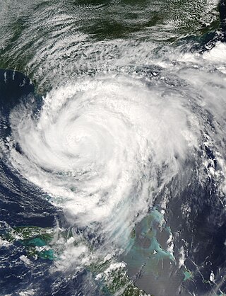
Hurricane Gaston was a minimal hurricane that made landfall in South Carolina on August 29, 2004. It then crossed North Carolina and Virginia before exiting to the northeast and dissipating. The storm killed nine people – eight of them directly – and caused $130 million (2004 USD) in damage. Gaston produced torrential downpours that inundated Richmond, Virginia. Although originally designated a tropical storm, Gaston was reclassified as a hurricane when post-storm analysis revealed it had maximum sustained winds of 75 mph (120 km/h).
The Hurricane Ivan tornado outbreak was a three-day tornado outbreak that was associated with the passage of Hurricane Ivan across the Southern United States starting on September 15, 2004, across the Gulf Coast states of Alabama and Florida as well as southern Georgia before ending in the Middle Atlantic Coast on September 18.
The Hurricane Frances tornado outbreak was a widespread tornado outbreak associated with Hurricane Frances that came ashore on eastern Florida on September 4–5, 2004. Outer bands from the hurricane and its remnants, when it moved across the Appalachian Mountains, produced one of the largest tornado outbreaks ever spawned by a tropical cyclone in the United States in terms of number of tornadoes confirmed since records were kept in 1950. In addition, it was the largest tornado outbreak in South Carolina history, with nearly half of the tornadoes in that state.
The tornado outbreak of March 28–29, 2010 affected the Southeast United States and The Bahamas on March 28-29, 2010.
A significant and deadly severe weather event that affected the Southeastern United States on March 3, 2019. Over the course of 6 hours, a total of 42 tornadoes touched down across portions of Alabama, Georgia, Florida, and South Carolina. The strongest of these was an EF4 tornado that devastated rural communities from Beauregard, Alabama, through Smiths Station, Alabama to Talbotton, Georgia, killing 23 people and injuring at least 100 others. Its death toll represented more than twice the number of tornado deaths in the United States in 2018 as well as the deadliest single tornado in the country since the 2013 Moore EF5 tornado. An EF3 tornado also destroyed residences to the east of Tallahassee in Leon County, Florida, and was only the second tornado of that strength in the county since 1945. Several other strong tornadoes occurred across the region throughout the evening of March 3 and caused significant damage. A large number of EF0 and EF1 tornadoes also touched down.
This page documents notable tornadoes and tornado outbreaks worldwide in 2020. Strong and destructive tornadoes form most frequently in the United States, Argentina, Brazil, Bangladesh, and eastern India, but can occur almost anywhere under the right conditions. Tornadoes also develop occasionally in southern Canada during the Northern Hemisphere's summer and somewhat regularly at other times of the year across Europe, Asia, Argentina, Australia and New Zealand. Tornadic events are often accompanied by other forms of severe weather, including strong thunderstorms, strong winds, and hail. There were 1,243 preliminary filtered reported tornadoes in 2020 in the United States in 2020, and 1,086 confirmed tornadoes in the United States in 2020. Worldwide, at least 93 tornado-related deaths were confirmed with 78 in the United States, eight in Vietnam, two each in Canada, Indonesia, and Mexico, and one in South Africa.
As Hurricane Isaias moved up the East Coast of the United States, a damaging outbreak of 39 tornadoes impacted areas from South Carolina to Connecticut between August 3–4, 2020. The most significant tornado of the outbreak was a large and intense EF3 tornado that obliterated a mobile home park near Windsor, North Carolina, killing two and injuring 14. This was the strongest tornado in the United States to be spawned by a tropical cyclone since 2005. In the end, the outbreak killed two and injured 26.
Hurricane Dorian caused severe flooding and hurricane-force winds over parts of the coastal Carolinas during early September 2019. After stalling over The Bahamas for three days as a Category 5 hurricane, Dorian proceeded generally to the northwest, before moving along the Atlantic Coast, striking the town of Buxton, North Carolina, on September 6.
This page documents notable tornadoes and tornado outbreaks worldwide in 2021. Strong and destructive tornadoes form most frequently in the United States, Argentina, Brazil, Bangladesh, and Eastern India, but can occur almost anywhere under the right conditions. Tornadoes also develop occasionally in southern Canada during the Northern Hemisphere's summer and somewhat regularly at other times of the year across Europe, Asia, Argentina, Australia and New Zealand. Tornadic events are often accompanied by other forms of severe weather, including strong thunderstorms, strong winds, and hail. Worldwide, 150 tornado-related deaths were confirmed with 103 in the United States, 28 in China, six in the Czech Republic, four in Russia, three in Italy, two in India, and one each in Canada, New Zealand, Indonesia, and Turkey.
This page documents notable tornadoes and tornado outbreaks worldwide in 2024. Strong and destructive tornadoes form most frequently in the United States, Argentina, Southern Brazil, the Bengal region and China, but can occur almost anywhere under the right conditions. Tornadoes also develop occasionally in southern Canada during summer in the Northern Hemisphere and somewhat regularly at other times of the year across Europe, South Africa, Japan, Australia and New Zealand. Tornadic events are often accompanied by other forms of severe weather, including thunderstorms, strong winds and hail.
A tornado outbreak spawned by Hurricane Beryl and its remnants impacted the South Central United States, Mississippi Valley, and Northeastern United States between July 8–10, 2024. Hurricane Beryl, which was the first major hurricane of the 2024 Atlantic hurricane season, made landfall in Texas as a Category 1 hurricane, and moved inland over the Southern United States, spawning numerous tornadoes across the states of Texas, Louisiana, and Arkansas on July 8. 110 tornado warnings were issued on July 8 alone, the most for any day in July. The outbreak also set new records for tornado warning issuances in a single day for the National Weather Service Offices in Shreveport and Buffalo, New York, at 67 and 9 respectively. With 67 recorded tornadoes, this was the most prolific tropical cyclone-related tornado outbreak in the United States since Hurricane Rita in 2005.
Hurricane Debby was a slow-moving and erratic Category 1 hurricane that caused widespread flooding across the Southeastern United States in early August 2024. The fourth named storm and second hurricane of the 2024 Atlantic hurricane season, Debby developed from a tropical wave that was first noted by the National Hurricane Center (NHC) on July 26. After crossing the Greater Antilles, the system began to organize over Cuba and was designated a potential tropical cyclone on August 2. After exiting off the southern coast of Cuba, the disturbance organized into a tropical depression early on August 3. Later that day, it became a tropical storm in the Florida Straits, being named Debby. It moved northwards and gradually intensified into a Category 1 hurricane before making landfall near Steinhatchee, Florida, early on August 5. Debby weakened once inland and began to slow down over the Southeastern United States, causing widespread flooding from heavy rain. It re-emerged in the Atlantic on August 7 before slowly moving northwards again, making landfall in South Carolina early on August 8 before weakening and becoming post-tropical the next day.