World Heritage Sites
† In danger
* Trans-border site
| Site | Image | Location | Criteria | Area ha (acre) | Year | Description | Refs |
|---|---|---|---|---|---|---|---|
| Antigua Guatemala |  | Sacatepéquez Department, 14°34′N90°40′W / 14.567°N 90.667°W | Cultural: (ii), (iii), (iv) | 49 (120) | 1979 | Founded in the early 16th century, Antigua was the capital of the Kingdom of Guatemala and its cultural, economic, religious, political and educational centre until a devastating earthquake in 1773. Its principal monuments have been preserved largely as ruins and are an excellent example of Spanish colonial architecture. | [3] |
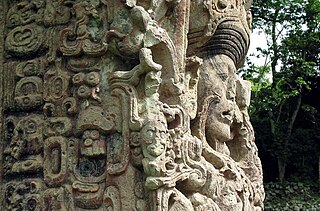
| Archaeological Park and Ruins of Quirigua |  | Izabal Department, 15°16′14″N89°2′25″W / 15.27056°N 89.04028°W | Cultural: (i), (ii), (iv) | — | 1981 | Quiriguá is an ancient Maya archaeological site that flourished during the Late Classic. The ruins of the site contain outstanding carved stelae and sculpted calendars. | [4] |
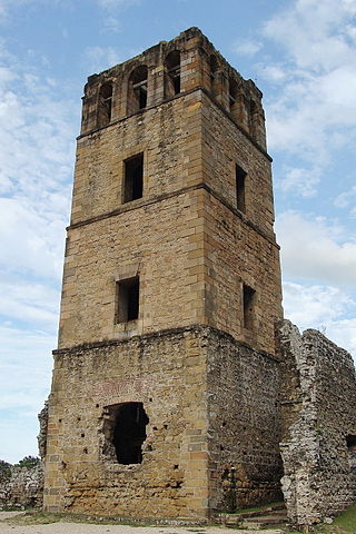
| Archaeological Site of Panamá Viejo and Historic District of Panamá |  | Panamá District, Panamá Province, 9°00′24″N79°29′06″W / 9.00667°N 79.48500°W | Cultural: (ii), (iv), (vi) | 57 (140) | 1997 [nb 1] | Founded in 1519, Panamá Viejo was the first European settlement on the Pacific coast of the Americas. The Historic District is a 17th-century replacement of the original town and preserves its street plan, architecture and blend of Spanish, French and early American styles. | [5] [6] |
| Area de Conservación Guanacaste |  | Guanacaste and Alajuela Provinces, 10°51′N85°37′W / 10.850°N 85.617°W | Natural: (ix), (x) | 147,000 (360,000) | 1999 [nb 2] | Stretching from the Pacific across the Cordillera de Guanacaste to the Atlantic, the site contains a range of habitats, including some of the most pristine wetland forests worldwide and the best dry forest habitats in Central America; that provide space for several threatened plant and animal species such as the saltwater crocodile, leatherback sea turtle, jaguar, jabiru, mahogany or guayacán. | [7] |
| Belize Barrier Reef Reserve System |  | Belize, Stann Creek and Toledo Districts, 17°19′N87°32′W / 17.317°N 87.533°W | Natural: (vii), (ix), (x) | 96,300 (238,000) | 1996 | The Belize Barrier Reef Reserve System is the largest reef system on the Northern Hemisphere and harbors several threatened species including sea turtles, manatees and the American crocodile. The site was listed as endangered from 2009 to 2018 due to mangrove cutting and overdevelopment. It was removed from the List in danger after a moratorium on oil exploration in the entire maritime zone of Belize and the strengthening of forestry regulations allowing for better protection of mangroves. | [8] [9] |
| Cocos Island National Park |  | Puntarenas Province, 5°32′N87°4′W / 5.533°N 87.067°W | Natural: (ix), (x) | 199,790 (493,700) | 1997 [nb 3] | As the only island in the tropical eastern Pacific, Cocos Island provides unique marine habitats for large pelagic fish such as sharks, tuna, dolphins or rays. | [10] [11] |
| Coiba National Park and its Special Zone of Marine Protection |  | Veraguas and Chiriquí Provinces, 7°26′N81°46′W / 7.433°N 81.767°W | Natural: (ix), (x) | 270,125 (667,490) | 2005 | The park protects islands and marine areas in the Gulf of Chiriquí and is home to an exceptionally large number of endemic mammals, birds and plants as well as to several threatened species. The marine ecosystem is characterized by a very large biodiversity with 760 species of marine fishes, 33 species of sharks and 20 species of cetaceans. | [12] |
| Darien National Park |  | Darién Province, 7°44′N77°33′W / 7.733°N 77.550°W | Natural: (vii), (ix), (x) | 597,000 (1,480,000) | 1981 | Situated on the border between South and Central America, the park consists of a wide range of habitats including sandy and rocky coastlines, mangroves, swamps, upland and lowland tropical forests. Two Indian tribes, the Chocó and the Kuna live in the property. | [13] |
| Fortifications on the Caribbean Side of Panama: Portobelo-San Lorenzo † |  | Colón Province, 9°33′14″N79°39′21″W / 9.55389°N 79.65583°W | Cultural: (i), (iv) | — | 1980 | As outstanding examples of Spanish military architecture, the forts were constructed in the 17th and 18th centuries to protect the Isthmus of Panama which had been of great importance to European colonial trade. | [14] |
| Joya de Cerén Archaeological Site |  | Opico, La Libertad Department, 13°49′39″N89°22′9″W / 13.82750°N 89.36917°W | Cultural: (iii), (iv) | — | 1993 | Joya de Cerén are the remains of a pre-Hispanic farming community that has been preserved largely intact buried under a volcanic eruption around 590 AD. It provides valuable archaeological for everyday life in the 6th century. | [15] |
| León Cathedral |  | León 12°26′06″N86°52′41″W / 12.43500°N 86.87806°W | Cultural: (ii), (iv) | 0.77 (1.9); buffer zone 13 (32) | 2011 | Built over more than 150 years starting in the mid-18th century, the cathedral's architecture is a fusion of different styles from Baroque to Neoclassicism and an expression of a new Latin American society that developed around the 18th century. | [16] |
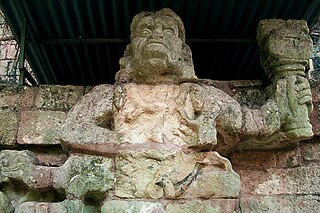
| Maya Site of Copan |  | Copán Department, 14°51′0″N89°8′0″W / 14.85000°N 89.13333°W | Cultural: (iv), (vi) | 15.095 (37.30); buffer zone 258.365 (638.43) | 1980 | Image is of Maya stelae H from Copán in Honduras | [17] |
| National Archaeological Park Tak’alik Ab’aj | 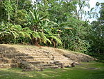 | Retalhuleu Department, 14°38′19″N91°42′57″W / 14.63861°N 91.71583°W | Cultural: (ii), (iii) | 14.88 (36.8) | 2023 | Archaeological site that that the transition from the Olmec civilization to the emergence of Early Mayan culture. | [18] |
| Precolumbian Chiefdom Settlements with Stone Spheres of the Diquís |  | Palmar Sur, 8°54′41″N83°28′39″W / 8.911389°N 83.477500°W | Cultural: (iii) | 6,172 (15,250); buffer zone 6,080 (15,000) | 2014 | [19] | |
| Río Plátano Biosphere Reserve † | 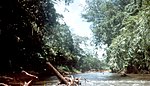 | La Mosquitia, 15°44′40″N84°40′30″W / 15.74444°N 84.67500°W | Natural: (vii), (viii), (ix), (x) | 500,000 (1,200,000) | 1982 | Endangered since 2011 | [20] |
| Ruins of León Viejo |  | Puerto Momotombo, Municipality La Paz Centro, Department of León, 12°23′50″N86°36′37″W / 12.39722°N 86.61028°W | Cultural: (iii), (iv) | — | 2000 | [21] | |
| Talamanca Range-La Amistad Reserves / La Amistad National Park |  | San José, Cartago, Limón and Puntarenas Provinces, 9°24′26″N82°56′20″W / 9.40722°N 82.93889°W | Natural: (vii), (viii), (ix), (x) | 567,845 (1,403,180) | 1983 [nb 4] | [22] [23] | |
| Tikal National Park |  | Petén Department, 17°13′N89°37′W / 17.217°N 89.617°W | Mixed: (i), (iii), (iv), (ix), (x) | 57,600 (142,000) | 1979 | [24] | |