List of World Heritage Sites in Eastern Asia

Last updated

The UNESCO (United Nations Educational, Scientific and Cultural Organization) has designated 99 World Heritage Sites in 5 countries (also called "state parties") of East Asia: China, Mongolia, North Korea, South Korea and Japan. [1] [2]

Contents

In this region, China is home to the most inscribed sites with number of 55. [3] The first sites from the region (and only sites designated in the 1980s or before) were the Great Wall of China, Mount Tai, the Peking Man Site at Zhoukoudian, Imperial Palace of the Ming and Qing Dynasties, the Mogao Caves and the Mausoleum of the First Qin Emperor, and all of them were in China. [4] Each year, UNESCO's World Heritage Committee may inscribe new sites on the list, or delist sites that no longer meet the criteria. Selection is based on ten criteria: six for cultural heritage (i–vi) and four for natural heritage (vii–x). [5] Some sites, designated "mixed sites," represent both cultural and natural heritage. In Eastern Asia, there are 74 cultural, 21 natural, and four mixed sites. [6]

The World Heritage Committee may also specify that a site is endangered, citing "conditions which threaten the very characteristics for which a property was inscribed on the World Heritage List." In this region there are no sites currently listed as endangered, nor have been listed previously. Possible danger listing has been considered by UNESCO in a number of other cases. [7]

Although a number of sites in Taiwan have been proposed, interference from PRC has prevented any site on the island from being listed. [8]

Legend

The table is sortable by column by clicking on the Sort both.gif at the top of the appropriate column; alphanumerically for the site, area, and year columns; by state party for the location column; and by criteria type for the criteria column. Transborder sites sort at the bottom.
Site; named after the World Heritage Committee's official designation [6]
Location; at city, regional, or provincial level and geocoordinates
Criteria; as defined by the World Heritage Committee [5]
Area; in hectares and acres. If available, the size of the buffer zone has been noted as well. A value of zero implies that no data has been published by UNESCO
Year; during which the site was inscribed to the World Heritage List
Description; brief information about the site, including reasons for qualifying as an endangered site, if applicable

World Heritage Sites

  * Trans-border site
SiteImageLocation Criteria Area
ha (acre)
YearDescriptionRefs
Ancient Building Complex in the Wudang Mountains Wudangshan pic 2.jpg Danjiangkou, Hubei, Flag of the People's Republic of China.svg  China
32°28′0″N111°0′0″E / 32.46667°N 111.00000°E / 32.46667; 111.00000 (Ancient Building Complex in the Wudang Mountains)
Cultural:
(i)(ii)(vi)
1994 [9]
Ancient City of Ping Yao Pingyao-oldtown.jpg Pingyao County, Shanxi, Flag of the People's Republic of China.svg  China
37°12′5″N112°9′16″E / 37.20139°N 112.15444°E / 37.20139; 112.15444 (Ancient City of Ping Yao)
Cultural:
(ii)(iii)(iv)
1997 [10]
Ancient Villages in Southern Anhui – Xidi and Hongcun Xidi - 05.JPG Huangshan City, Yi County, Anhui, Flag of the People's Republic of China.svg  China
29°54′16″N117°59′15″E / 29.90444°N 117.98750°E / 29.90444; 117.98750 (Ancient Villages in Southern Anhui – Xidi and Hongcun)
Cultural:
(iii)(iv)(v)
52 (130); buffer zone 730 (1,800)2000 [11]
Archaeological Ruins of Liangzhu City Liangzhu Ancient City Site, 2016-06-18 12.jpg Zhejiang, Flag of the People's Republic of China.svg  China
30°23′44″N119°59′27″E / 30.39556°N 119.99083°E / 30.39556; 119.99083 (Archaeological Ruins of Liangzhu City)
Cultural:
(iii)(iv)
1,433.66 (3,542.7); buffer zone 9,980.29 (24,661.8)2019 [12]
Baekje Historic Areas gongsanseong geumseoru.jpg Buyeo, Gongju and Iksan, Flag of South Korea.svg  South Korea
36°27′43″N127°07′38″E / 36.46194°N 127.12722°E / 36.46194; 127.12722 (Baekje Historic Areas)
Cultural:
(ii)(iii)
135.1 (334); buffer zone 303.64 (750.3)2015 [13]
Buddhist Monuments in the Horyu-ji Area Horyu-ji11s3200.jpg Nara Prefecture, Flag of Japan.svg  Japan
34°37′0″N135°44′0″E / 34.61667°N 135.73333°E / 34.61667; 135.73333 (Buddhist Monuments in the Horyu-ji Area)
Cultural:
(i)(ii)(iv)(vi)
15 (37); buffer zone 571 (1,410)1993 [14]
Capital Cities and Tombs of the Ancient Koguryo Kingdom Kevsunblush2.JPG Huanren Manchu Autonomous County, Liaoning and Ji'an, Jilin, Flag of the People's Republic of China.svg  China
41°9′25″N126°11′14″E / 41.15694°N 126.18722°E / 41.15694; 126.18722 (Capital Cities and Tombs of the Ancient Koguryo Kingdom)
Cultural:
(i)(ii)(iii)(iv)(v)
4,165 (10,290); buffer zone 14,142 (34,950)2004 [15]
Changdeokgung Palace Complex Changdeokgung-Injeongjeon.jpg Seoul, Flag of South Korea.svg  South Korea
37°34′46″N126°59′28″E / 37.57944°N 126.99111°E / 37.57944; 126.99111 (Changdeokgung Palace Complex)
Cultural:
(ii)(iii)(iv)
1997 [16]
Chengjiang Fossil Site
Haikouella lanceolata China.jpg
Yunnan, Flag of the People's Republic of China.svg  China
28°25′19″N106°2′33″E / 28.42194°N 106.04250°E / 28.42194; 106.04250 (Chengjiang Fossil Site)
Natural:
(viii)
512 (1,270); buffer zone 220 (540)2012 [17]
China Danxia Danxia 0822.JPG Various regions of China, Flag of the People's Republic of China.svg  China
28°25′19″N106°2′33″E / 28.42194°N 106.04250°E / 28.42194; 106.04250 (China Danxia)
Natural:
(vii)(viii)
82,151 (203,000); buffer zone 218,357 (539,570)2010 [18]
Classical Gardens of Suzhou Xiangzhou of Zhuozhengyuan Suzhou 4th Aug 2006.jpg Suzhou, Jiangsu, Flag of the People's Republic of China.svg  China
31°19′0″N120°27′0″E / 31.31667°N 120.45000°E / 31.31667; 120.45000 (Classical Gardens of Suzhou)
Cultural:
(i)(ii)(iii)(iv)(v)
12 (30); buffer zone 27 (67)1997 [nb 1] [19]
Complex of Koguryo Tombs Tomb of King Dongmyeong of Goguryeo in Pyongyang.jpg Pyongyang and Nampho, Flag of North Korea.svg  North Korea
38°51′47″N125°24′54″E / 38.86306°N 125.41500°E / 38.86306; 125.41500 (Complex of Koguryo Tombs)
Cultural:
(i)(ii)(iii)(iv)
233 (580); buffer zone 1,701 (4,200)2004 [20]
Cultural Landscape of Honghe Hani Rice Terraces Subsistent Farming Southern China.jpg Yuanyang County, Yunnan, Flag of the People's Republic of China.svg  China
23°5′36″N102°46′48″E / 23.09333°N 102.78000°E / 23.09333; 102.78000 (Cultural Landscape of Honghe Hani Rice Terraces)
Cultural:
(iii)(v)
16,603 (41,030); buffer zone 29,501 (72,900)2013 [21]
Dazu Rock Carvings Da Zu Shi Ke .JPG Chongqing, Flag of the People's Republic of China.svg  China
29°42′4″N105°42′18″E / 29.70111°N 105.70500°E / 29.70111; 105.70500 (Dazu Rock Carvings)
Cultural:
(i)(ii)(iii)
20 (49); buffer zone 211 (520)1999 [22]
Fanjingshan Fan Jing Shan Hong Yun Jin Ding (Xin Jin Ding ).jpg Guizhou, Flag of the People's Republic of China.svg  China
27°53′44″N108°40′48″E / 27.89556°N 108.68000°E / 27.89556; 108.68000 (Fanjingshan)
Natural:
(x)
40,275 (99,520); buffer zone 37,239 (92,020)2018 [23]
Fujian Tulou Snail pit tulou.jpg Fujian, Flag of the People's Republic of China.svg  China
25°1′23″N117°41′9″E / 25.02306°N 117.68583°E / 25.02306; 117.68583 (Fujian Tulou)
Cultural:
(iii)(iv)(v)
153 (380); buffer zone 935 (2,310)2008 [24]
Fujisan, sacred place and source of artistic inspiration 080103 hakkai fuji.jpg Chūbu region, Flag of Japan.svg  Japan
35°21′39″N138°43′39″E / 35.36083°N 138.72750°E / 35.36083; 138.72750 (Fujisan, sacred place and source of artistic inspiration)
Cultural:
(iii)(vi)
20,702 (51,160); buffer zone 49,628 (122,630)2013 [25]
Gaya Tumuli Changnyeong royal graves.JPG Changnyeong, Gimhae, Goryeong, Goseong, Haman, Hapcheon and Namwon, Flag of South Korea.svg  South Korea
35°14′14.15″N128°52′25.41″E / 35.2372639°N 128.8737250°E / 35.2372639; 128.8737250 (Gaya Tumuli)
Cultural:
(iii)
189 (470); buffer zone 964.8 (2,384)2023 [26]
Getbol, Korean Tidal Flats gocanggaesbeol.jpg Boseong, Gochang, Seocheon, Sinan and Suncheon, Flag of South Korea.svg  South Korea
35°27′35″N126°26′42″E / 35.45972°N 126.44500°E / 35.45972; 126.44500 (Getbol, Korean Tidal Flats)
Natural:
(x)
128,411 (317,310); buffer zone 74,592 (184,320)2021 [27]
Gochang, Hwasun and Ganghwa Dolmen Sites Korea-Gwangju-Gochang Dolmens 5350-06.JPG Gochang, Jeollabuk-do; Hwasun, Jeollanam-do and Ganghwa, Incheon, Flag of South Korea.svg  South Korea
34°58′0″N126°55′45″E / 34.96667°N 126.92917°E / 34.96667; 126.92917 (Gochang, Hwasun and Ganghwa Dolmen Sites)
Cultural:
(iii)
52 (130); buffer zone 315 (780)2000 [28]
Gusuku Sites and Related Properties of the Kingdom of Ryukyu Naha Shuri Castle16s5s3200.jpg Okinawa Prefecture, Flag of Japan.svg  Japan
26°12′31″N127°40′58″E / 26.20861°N 127.68278°E / 26.20861; 127.68278 (Gusuku Sites and Related Properties of the Kingdom of Ryukyu)
Cultural:
(ii)(iii)(vi)
55 (140); buffer zone 560 (1,400)2000 [29]
Gyeongju Historic Areas Gyeongju, South Korea Gjt0001.jpg Gyeongju, Gyeongsangbuk-do, Flag of South Korea.svg  South Korea
35°47′20″N129°13′36″E / 35.78889°N 129.22667°E / 35.78889; 129.22667 (Gyeongju Historic Areas)
Cultural:
(ii)(iii)
2,880 (7,100); buffer zone 350 (860)2000 [30]
Haeinsa Temple Janggyeong Panjeon, the Depositories for the Tripitaka Koreana Woodblocks Korea-Haeinsa-Tripitaka Koreana-01.jpg Hapcheon, Gyeongsangnam-do, Flag of South Korea.svg  South Korea
35°48′0″N128°6′0″E / 35.80000°N 128.10000°E / 35.80000; 128.10000 (Haeinsa Temple Janggyeong Panjeon, the Depositories for the Tripitaka Koreana Woodblocks)
Cultural:
(iv)(vi)
1995 [31]
Hidden Christian Sites in the Nagasaki Region Oura Cathoilc Church.jpg Nagasaki Prefecture, Flag of Japan.svg  Japan
32°44′03″N129°52′13″E / 32.734106°N 129.870236°E / 32.734106; 129.870236 (Ōura Cathedral)
Cultural:
(iii)
5,566.55 (13,755.2); buffer zone 12,252.52 (30,276.6)2018 [32]
Himeji-jo Himeji Castle The Keep Towers.jpg Hyōgo Prefecture, Flag of Japan.svg  Japan
34°50′0″N134°42′0″E / 34.83333°N 134.70000°E / 34.83333; 134.70000 (Himeji-jo)
Cultural:
(i)(iv)
107 (260); buffer zone 143 (350)1993 [33]
Hiraizumi – Temples, Gardens and Archaeological Sites Representing the Buddhist Pure Land 230728 Motsuji Hiraizumi Iwate pref Japan13s3.jpg Iwate Prefecture, Flag of Japan.svg  Japan
34°37′0″N135°44′0″E / 34.61667°N 135.73333°E / 34.61667; 135.73333 (Hiraizumi – Temples, Gardens and Archaeological Sites Representing the Buddhist Pure Land)
Cultural:
(ii)(vi)
176 (430); buffer zone 6,008 (14,850)2011 [34]
Hiroshima Peace Memorial (Genbaku Dome) HiroshimaGembakuDome6747.jpg Hiroshima, Hiroshima Prefecture, Flag of Japan.svg  Japan
34°23′0″N132°27′0″E / 34.38333°N 132.45000°E / 34.38333; 132.45000 (Hiroshima Peace Memorial (Genbaku Dome))
Cultural:
(vi)
0.40 (0.99); buffer zone 43 (110)1996 [35]
Historic Centre of Macao Ruinas de Sao Paulo.jpg Flag of Macau.svg  Macau Special Administrative Region, Flag of the People's Republic of China.svg  China
22°11′29″N113°32′11″E / 22.19139°N 113.53639°E / 22.19139; 113.53639 (Historic Centre of Macao)
Cultural:
(ii)(iii)(iv)(vi)
16 (40); buffer zone 107 (260)2005 [36]
Historic Ensemble of the Potala Palace, Lhasa SG105186.jpg Lhasa, Tibet Autonomous Region, Flag of the People's Republic of China.svg  China
29°39′29″N91°7′2″E / 29.65806°N 91.11722°E / 29.65806; 91.11722 (Historic Ensemble of the Potala Palace, Lhasa)
Cultural:
(i)(iv)(vi)
61 (150); buffer zone 199 (490)1994 [nb 2] [37]
[38]
[39]
Historic Monuments and Sites in Kaesong Nam Gate in Kaesong (5063812320).jpg Kaesong, Flag of North Korea.svg  North Korea
37°58′54″N126°30′29″E / 37.98167°N 126.50806°E / 37.98167; 126.50806 (Historic Monuments and Sites in Kaesong)
Cultural:
(ii)(iii)
494 (1,220); buffer zone 5,222 (12,900)2013 [40]
Historic Monuments of Ancient Kyoto (Kyoto, Uji and Otsu Cities) Kinkakuji 2004-09-21.jpg Kyoto and Shiga Prefectures, Flag of Japan.svg  Japan
34°58′50″N135°46′10″E / 34.98056°N 135.76944°E / 34.98056; 135.76944 (Historic Monuments of Ancient Kyoto (Kyoto, Uji and Otsu Cities))
Cultural:
(ii)(iv)
1,056 (2,610); buffer zone 3,579 (8,840)1994 [41]
Historic Monuments of Ancient Nara Kofukuji0411.jpg Nara, Nara Prefecture, Flag of Japan.svg  Japan
34°40′32″N135°50′22″E / 34.67556°N 135.83944°E / 34.67556; 135.83944 (Historic Monuments of Ancient Nara)
Cultural:
(ii)(iii)(iv)(vi)
617 (1,520); buffer zone 2,502 (6,180)1998 [42]
Historic Monuments of Dengfeng in “The Centre of Heaven and Earth” Shaolinsi.JPG Henan, Flag of the People's Republic of China.svg  China
34°27′32″N113°4′4″E / 34.45889°N 113.06778°E / 34.45889; 113.06778 (Historic Monuments of Dengfeng in “The Centre of Heaven and Earth”)
Cultural:
(iii)(vi)
825 (2,040); buffer zone 3,438 (8,500)2010 [43]
Historic Villages of Korea: Hahoe and Yangdong Korea-Gyeongju-Yangdong.Village.jpg Andong and Gyeongju, Gyeongsangbuk-do, Flag of South Korea.svg  South Korea
36°32′21″N128°31′0″E / 36.53917°N 128.51667°E / 36.53917; 128.51667 (Historic Villages of Korea: Hahoe and Yangdong)
Cultural:
(iii)(iv)
600 (1,500); buffer zone 885 (2,190)2010 [44]
Historic Villages of Shirakawa-go and Gokayama Ogi Shirakawa-go, Gifu, Japan.jpg Gifu and Toyama Prefectures, Flag of Japan.svg  Japan
36°24′0″N136°53′0″E / 36.40000°N 136.88333°E / 36.40000; 136.88333 (Historic Villages of Shirakawa-go and Gokayama)
Cultural:
(iv)(v)
68 (170); buffer zone 58,873 (145,480)1995 [45]
Huanglong Scenic and Historic Interest Area 1 huanglong 2011x.jpg Songpan County, Sichuan, Flag of the People's Republic of China.svg  China
32°45′15″N103°49′20″E / 32.75417°N 103.82222°E / 32.75417; 103.82222 (Huanglong Scenic and Historic Interest Area)
Natural:
(vii)
60,000 (150,000)1992 [46]
Hwaseong Fortress Bifyu 8.jpg Suwon, Gyeonggi-do, Flag of South Korea.svg  South Korea
37°16′20″N127°0′30″E / 37.27222°N 127.00833°E / 37.27222; 127.00833 (Hwaseong Fortress)
Cultural:
(ii)(iii)
1997 [47]
Imperial Palaces of the Ming and Qing Dynasties in Beijing and Shenyang Forbidden City Courtyard.jpg Beijing and Shenyang, Flag of the People's Republic of China.svg  China
41°47′39″N123°26′49″E / 41.79417°N 123.44694°E / 41.79417; 123.44694 (Imperial Palaces of the Ming and Qing Dynasties in Beijing and Shenyang)
Cultural:
(i)(ii)(iii)(iv)
13 (32); buffer zone 153 (380)1987 [nb 3] [48]
Imperial Tombs of the Ming and Qing Dynasties Mingdynastytombs3.jpg Nanjing, Jiangsu; Changping District, Beijing; Liaoning; Hubei, Flag of the People's Republic of China.svg  China
41°42′26″N124°47′38″E / 41.707222°N 124.793889°E / 41.707222; 124.793889 (Imperial Tombs of the Ming and Qing Dynasties)
Cultural:
(i)(ii)(iii)(iv)(vi)
3,435 (8,490); buffer zone 23,429 (57,890)2000 [nb 4] [49]
[50]
[51]
Itsukushima Shinto Shrine Itsukushima torii distance.jpg Itsukushima, Hiroshima Prefecture, Flag of Japan.svg  Japan
34°17′40″N132°19′29″E / 34.29444°N 132.32472°E / 34.29444; 132.32472 (Itsukushima Shinto Shrine)
Cultural:
(i)(ii)(iv)(vi)
431 (1,070); buffer zone 2,634 (6,510)1996 [52]
Iwami Ginzan Silver Mine and its Cultural Landscape 180504 Shimizudani Refinery Ruins of Iwami Ginzan Silver Mine Oda Shimane pref Japan04s.jpg Ōda, Shimane Prefecture, Flag of Japan.svg  Japan
35°6′46″N132°26′6″E / 35.11278°N 132.43500°E / 35.11278; 132.43500 (Iwami Ginzan Silver Mine and its Cultural Landscape)
Cultural:
(ii)(iii)(v)
529 (1,310); buffer zone 3,134 (7,740)2007 [nb 5] [53]
[54]
Jeju Volcanic Island and Lava Tubes Halasan.jpg Jeju-do, Flag of South Korea.svg  South Korea
33°28′8″N126°43′13″E / 33.46889°N 126.72028°E / 33.46889; 126.72028 (Jeju Volcanic Island and Lava Tubes)
Natural:
(vii)(viii)
9,475 (23,410); buffer zone 9,371 (23,160)2007 [55]
Jiuzhaigou Valley Scenic and Historic Interest Area
1 jiuzhaigou valley national park wu hua hai.jpg
Jiuzhaigou County, Sichuan, Flag of the People's Republic of China.svg  China
33°5′0″N103°55′0″E / 33.08333°N 103.91667°E / 33.08333; 103.91667 (Jiuzhaigou Valley Scenic and Historic Interest Area)
Natural:
(vii)
72,000 (180,000)1992 [56]
Jongmyo Shrine Jongmyo-Jeongjeon.jpg Seoul, Flag of South Korea.svg  South Korea
37°33′0″N126°59′0″E / 37.55000°N 126.98333°E / 37.55000; 126.98333 (Jongmyo Shrine)
Cultural:
(iv)
19 (47)1995 [57]
Kaiping Diaolou and Villages
Kaiping September 2007.jpg
Guangdong, Flag of the People's Republic of China.svg  China
29°54′16″N117°59′15″E / 29.90444°N 117.98750°E / 29.90444; 117.98750 (Kaiping Diaolou and Villages)
Cultural:
(ii)(iii)(iv)
372 (920); buffer zone 2,738 (6,770)2007 [58]
Landscapes of Dauria]] Sopki na severe ozera Zun-Torei.jpg Dornod Province, Flag of Mongolia.svg  Mongolia*; Zabaykalsky Krai, Flag of Russia.svg  Russia*
49°55′N115°25′E / 49.917°N 115.417°E / 49.917; 115.417 (Landscapes of Dauria)
Natural:
(ix), (x)
912,624 (2,255,140); buffer zone 307,317 (759,400)2017 [59]
Longmen Grottoes Longmen-lu-she-na-1.jpg Luoyang, Henan, Flag of the People's Republic of China.svg  China
34°28′0″N112°28′0″E / 34.46667°N 112.46667°E / 34.46667; 112.46667 (Longmen Grottoes)
Cultural:
(i)(ii)(iii)
331 (820); buffer zone 1,042 (2,570)2000 [60]
Lushan National Park Lu Lin Hu .JPG Jiujiang, Jiangxi, Flag of the People's Republic of China.svg  China
29°26′0″N115°52′0″E / 29.43333°N 115.86667°E / 29.43333; 115.86667 (Lushan National Park)
Cultural:
(ii)(iii)(iv)(vi)
1996 [61]
Mausoleum of the First Qin Emperor Terracotta Army-China2.jpg Lintong District, Xi'an, Shaanxi, Flag of the People's Republic of China.svg  China
34°23′0″N109°6′0″E / 34.38333°N 109.10000°E / 34.38333; 109.10000 (Mausoleum of the First Qin Emperor)
Cultural:
(i)(iii)(iv)(vi)
1987 [62]
Migratory Bird Sanctuaries along the Coast of Yellow SeaBohai Gulf of China (Phase I) Jiangsu, Flag of the People's Republic of China.svg  China
32°55′55″N121°1′0.53″E / 32.93194°N 121.0168139°E / 32.93194; 121.0168139 (Migratory Bird Sanctuaries along the Coast of Yellow Sea–Bohai Gulf of China (Phase I))
Natural:
(x)
188,643 (466,150); buffer zone 80,056 (197,820)2019 [63]
Mogao Caves Bandit attack.JPG Dunhuang, Gansu, Flag of the People's Republic of China.svg  China
40°8′0″N94°49′0″E / 40.13333°N 94.81667°E / 40.13333; 94.81667 (Mogao Caves)
Cultural:
(i)(ii)(iii)(iv)(v)(vi)
1987 [64]
Mountain Resort and its Outlying Temples, Chengde Chengde Mountain Resort 1.jpg Chengde, Hebei, Flag of the People's Republic of China.svg  China
40°59′13″N117°56′18″E / 40.98694°N 117.93833°E / 40.98694; 117.93833 (Mountain Resort and its Outlying Temples, Chengde)
Cultural:
(ii)(iv)
1994 [65]
Mount Emei Scenic Area, including Leshan Giant Buddha Scenic Area Leshan Buddha Statue View.JPG Emeishan City, Sichuan, Flag of the People's Republic of China.svg  China
29°32′42″N103°46′10″E / 29.54500°N 103.76944°E / 29.54500; 103.76944 (Mount Emei Scenic Area, including Leshan Giant Buddha Scenic Area)
Mixed:
(iv)(vi)(x)
15,400 (38,000)1996 [66]
Mount Huangshan Huangshan pic 4.jpg Anhui, Flag of the People's Republic of China.svg  China
30°10′N118°11′E / 30.167°N 118.183°E / 30.167; 118.183 (Mount Huangshan)
Mixed:
(ii)(vii)(x)
15,400 (38,000)1990 [67]
Mount Qingcheng and the Dujiangyan Irrigation System Da Zu Shi Ke .JPG Dujiangyan City, Sichuan, Flag of the People's Republic of China.svg  China
29°42′4″N105°42′18″E / 29.70111°N 105.70500°E / 29.70111; 105.70500 (Mount Qingcheng and the Dujiangyan Irrigation System)
Cultural:
(ii)(iv)(vi)
2000 [68]
Mount Sanqingshan National Park Sanqingshan 1461.JPG Jiangxi, Flag of the People's Republic of China.svg  China
28°54′57″N118°3′52″E / 28.91583°N 118.06444°E / 28.91583; 118.06444 (Mount Sanqingshan National Park)
Natural:
(vii)
22,950 (56,700); buffer zone 16,850 (41,600)2008 [69]
Mount Taishan Mount tai azure clouds temple.jpg Tai'an and Jinan, Shandong, Flag of the People's Republic of China.svg  China
36°16′N117°6′E / 36.267°N 117.100°E / 36.267; 117.100 (Mount Taishan)
Mixed:
(i)(ii)(iii)(iv)(v)(vi)(vii)
25,000 (62,000)1987 [70]
Mount Wutai Wu Tai Shan -Bai Ta .JPG Shanxi, Flag of the People's Republic of China.svg  China
39°1′50″N113°33′48″E / 39.03056°N 113.56333°E / 39.03056; 113.56333 (Mount Wutai)
Cultural:
(ii)(iii)(iv)(vi)
18,415 (45,500); buffer zone 42,312 (104,560)2009 [71]
Mount Wuyi Wuyi Mountains Sea of clouds 4.jpg Wuyishan City, Fujian, Flag of the People's Republic of China.svg  China
27°43′N117°41′E / 27.717°N 117.683°E / 27.717; 117.683 (Mount Wuyi)
Mixed:
(iii)(vi)(vii)(x)
99,975 (247,040); buffer zone 27,888 (68,910)1999 [72]
Mozu-Furuichi Kofun Group NintokuTomb Aerial photograph 2007.jpg Osaka Prefecture, Flag of Japan.svg  Japan
34°33′44″N135°36′34″E / 34.56222°N 135.60944°E / 34.56222; 135.60944 (Mozu-Furuichi Kofun Group)
Cultural:
(iii)(iv)
166.66 (411.8); buffer zone 890 (2,200)2019 [73]
Namhansanseong namhansanseong nammun.jpg Gwangju, Gyeonggi-do, Flag of South Korea.svg  South Korea
37°28′44″N127°10′52″E / 37.47889°N 127.18111°E / 37.47889; 127.18111 (Namhansanseong)
Cultural:
(ii)(iv)
409.06 (1,010.8); buffer zone 853.71 (2,109.6)2014 [74]
Ogasawara Islands Minamijima, Ogasawara, Tokyo.jpg Ogasawara Subprefecture, Flag of Japan.svg  Japan
27°43′6″N142°5′59″E / 27.71833°N 142.09972°E / 27.71833; 142.09972 (Ogasawara Islands)
Natural:
(ix)
7,939 (19,620)2011 [75]
Old Town of Lijiang 1 lijiang old town 2012a.jpg Lijiang, Yunnan, Flag of the People's Republic of China.svg  China
26°52′0″N100°14′0″E / 26.86667°N 100.23333°E / 26.86667; 100.23333 (Old Town of Lijiang)
Cultural:
(ii)(iv)(v)
1997 [76]
Orkhon Valley Cultural Landscape Orchon-mongolei.JPG Orkhon Province, Flag of Mongolia.svg  Mongolia
47°33′N102°50′E / 47.550°N 102.833°E / 47.550; 102.833 (Orkhon Valley Cultural Landscape)
Cultural:
(ii)(iii)(iv)
121,976 (301,410); buffer zone 61,044 (150,840)2004 [77]
Peking Man Site at Zhoukoudian Zhoukoudian Peking Man Site.jpg Fangshan District, Beijing, Flag of the People's Republic of China.svg  China
39°44′0″N115°55′0″E / 39.73333°N 115.91667°E / 39.73333; 115.91667 (Peking Man Site at Zhoukoudian)
Cultural:
(iii)(vi)
1987 [78]
Petroglyphic Complexes of the Mongolian Altai Petroglyphic Complexes of the Altai, Mongolia.jpg Flag of Mongolia.svg  Mongolia
49°20′N88°24′E / 49.333°N 88.400°E / 49.333; 88.400 (Petroglyphic Complexes of the Mongolian Altai)
Cultural:
(iii)
11,300 (28,000); buffer zone 10,700 (26,000)2011 [79]
Royal Tombs of the Joseon Dynasty Sejong tomb 1.jpg Flag of South Korea.svg  South Korea
37°11′50″N128°27′10″E / 37.19722°N 128.45278°E / 37.19722; 128.45278 (Royal Tombs of the Joseon Dynasty)
Cultural:
(iii)(iv)(vi)
1,891 (4,670); buffer zone 4,660 (11,500)2009 [80]
Sacred Sites and Pilgrimage Routes in the Kii Mountain Range
Danjogaran Koyasan12n3200.jpg
Mie, Nara and Wakayama Prefectures, Flag of Japan.svg  Japan
33°50′13″N135°46′35″E / 33.83694°N 135.77639°E / 33.83694; 135.77639 (Sacred Sites and Pilgrimage Routes in the Kii Mountain Range)
Cultural:
(ii)(iii)(iv)(vi)
495 (1,220); buffer zone 1,137 (2,810)2004 [81]
Sansa, Buddhist Mountain Monasteries in Korea Korea-Boeun-Beopjusa Palsangjeon 1782-06.JPG Tongdosa, Buseoksa, Bongjeongsa, Beopjusa, Magoksa, Seonamsa and Daeheungsa, Flag of South Korea.svg  South Korea.
35°29′17″N129°03′56″E / 35.48806°N 129.06556°E / 35.48806; 129.06556 (Sansa, Buddhist Mountain Monasteries in Korea)
Cultural:
(iii)
55.43 (137.0); buffer zone 1,323.11 (3,269.5)2018 [82]
Seokguram Grotto and Bulguksa Temple
Seokguram Buddha.JPG
Gyeongju, Gyeongsangbuk-do, Flag of South Korea.svg  South Korea
35°47′0″N129°21′0″E / 35.78333°N 129.35000°E / 35.78333; 129.35000 (Seokguram Grotto and Bulguksa Temple)
Cultural:
(i)(iv)
1995 [83]
Seowon, Korean Neo-Confucian Academies Korea-Andong-Dosan Seowon 3015-06.JPG Flag of South Korea.svg  South Korea
36°43′38.27″N128°50′36.34″E / 36.7272972°N 128.8434278°E / 36.7272972; 128.8434278 (Seowon)
Cultural:
(iii)
102.49 (253.3); buffer zone 796.74 (1,968.8)2019 [84]
Shirakami-Sanchi Sirakami santi.JPG Ajigasawa and Fukaura, Nishitsugaru District, Aomori Prefecture; Fujisato, Yamamoto District, Akita Prefecture, Flag of Japan.svg  Japan
40°28′12″N140°7′48″E / 40.47000°N 140.13000°E / 40.47000; 140.13000 (Shirakami-Sanchi)
Natural:
(ix)
16,939 (41,860)1993 [85]
Shiretoko 140829 Ichiko of Shiretoko Goko Lakes Hokkaido Japan01s5.jpg Hokkaido Prefecture, Flag of Japan.svg  Japan
43°56′58″N144°57′57″E / 43.94944°N 144.96583°E / 43.94944; 144.96583 (Shiretoko National Park)
Natural:
(ix)(x)
71,100 (176,000)2005 [86]
Shrines and Temples of Nikko Taiyu-in Mausoleum Niomon.jpg Nikkō, Tochigi Prefecture, Flag of Japan.svg  Japan
36°44′51″N139°36′38″E / 36.74750°N 139.61056°E / 36.74750; 139.61056 (Shrines and Temples of Nikko)
Cultural:
(i)(iv)(vi)
51 (130); buffer zone 373 (920)1999 [87]
Sichuan Giant Panda Sanctuaries Chengdu-pandas-d10.jpg Sichuan, Flag of the People's Republic of China.svg  China
30°50′0″N103°0′0″E / 30.83333°N 103.00000°E / 30.83333; 103.00000 (Sichuan Giant Panda Sanctuaries)
Natural:
(x)
924,500 (2,284,000); buffer zone 527,100 (1,302,000)2006 [88]
Silk Roads: the Routes Network of Chang'an-Tianshan Corridor Dayanta Gisela-Brantl 01.JPG 22 sites in Flag of the People's Republic of China.svg  China*: Luoyang, Lingbao and Xin'an of Henan Province; Xi'an, Bin County and Chenggu of Shaanxi Province; Tianshui, Yongjing, Dunhuang and Anxi of Gansu Province; Turpan, Jimsar and Kuqa of Xinjiang Uyghur Autonomous Region. 8 sites in Flag of Kazakhstan.svg  Kazakhstan*: Almaty Region and Jambyl Region. 3 sites in Flag of Kyrgyzstan (2023).svg  Kyrgyzstan*: Chüy Region
34°18′16″N108°51′26″E / 34.304444°N 108.857222°E / 34.304444; 108.857222 (Silk Roads: the Routes Network of Chang'an-Tianshan Corridor)
Cultural:
(ii)(iii)(iv)(vi)
42,668.16 (105,435.3); buffer zone 189,963.13 (469,409.1)2014 [89]
Site of Xanadu John-Speed-The-Kingdome-of-China-1626-2544.jpg Inner Mongolia, Flag of the People's Republic of China.svg  China
30°50′0″N103°0′0″E / 30.83333°N 103.00000°E / 30.83333; 103.00000 (Site of Xanadu)
Cultural:
(ii) (iii) (iv) (vi)
25,131 (62,100); buffer zone 150,722 (372,440)2012 [90]
South China Karst Shi Lin Zheng Men .JPG Guangxi, Guizhou and Yunnan, Flag of the People's Republic of China.svg  China
25°13′15″N107°58′30″E / 25.22083°N 107.97500°E / 25.22083; 107.97500 (South China Karst)
Natural:
(vii)(viii)
47,588 (117,590); buffer zone 98,428 (243,220)2007 [91]
Summer Palace, an Imperial Garden in Beijing Pai Yun Dian.jpg Beijing, Flag of the People's Republic of China.svg  China
39°54′38″N116°8′28″E / 39.91056°N 116.14111°E / 39.91056; 116.14111 (Summer Palace, an Imperial Garden in Beijing)
Cultural:
(i)(ii)(iii)
1998 [92]
Temple and Cemetery of Confucius and the Kong Family Mansion in Qufu
Confuciustempleapricotplatform.jpg
Qufu, Shandong, Flag of the People's Republic of China.svg  China
35°36′42″N116°58′30″E / 35.61167°N 116.97500°E / 35.61167; 116.97500 (Temple and Cemetery of Confucius and the Kong Family Mansion in Qufu)
Cultural:
(i)(iv)(vi)
1994 [93]
Temple of Heaven: an Imperial Sacrificial Altar in Beijing 11 Temple of Heaven.jpg Beijing, Flag of the People's Republic of China.svg  China
39°50′44″N116°26′41″E / 39.84556°N 116.44472°E / 39.84556; 116.44472 (Temple of Heaven: an Imperial Sacrificial Altar in Beijing)
Cultural:
(i)(ii)(iii)
1998 [94]
The Architectural Work of Le Corbusier, an Outstanding Contribution to the Modern Movement National museum of western art05s3200.jpg Flag of Argentina.svg  Argentina*, Flag of Belgium (civil).svg  Belgium*, Flag of France.svg  France*, Flag of Germany.svg  Germany*, Flag of India.svg  India*, Flag of Japan.svg  Japan*, Flag of Switzerland (Pantone).svg   Switzerland*
35°42′55″N139°46′33″E / 35.71528°N 139.77583°E / 35.71528; 139.77583 (The Architectural Work of Le Corbusier, an Outstanding Contribution to the Modern Movement)
Cultural:
(i)(ii)(vi)
2016 [95]
The Great Wall Great Wall of China July 2006.JPG Various regions of China, Flag of the People's Republic of China.svg  China
40°25′N116°5′E / 40.417°N 116.083°E / 40.417; 116.083 (The Great Wall)
Cultural:
(i)(ii)(iii)(iv)(vi)
1987 [96]
Three Parallel Rivers of Yunnan Protected Areas Yangzi River - by Peter Morgan.jpg Yunnan, Flag of the People's Republic of China.svg  China
27°53′42″N98°24′23″E / 27.89500°N 98.40639°E / 27.89500; 98.40639 (Three Parallel Rivers of Yunnan Protected Areas)
Natural:
(vii)(viii)(ix)(x)
2003 [nb 6] [97]
[98]
Uvs Nuur Basin Uvs-noor.jpg Uvs, Zavkhan and Khövsgöl Provinces Flag of Mongolia.svg  Mongolia*; Mongun-Tayginsky, Ovyursky, Tes-Khemsky and Erzinsky Districts, Tuva Republic, Flag of Russia.svg  Russia*
50°16′30″N92°43′1″E / 50.27500°N 92.71694°E / 50.27500; 92.71694 (Uvs Nuur Basin))
Natural:
(ix)(x)
898,064 (2,219,160); buffer zone 170,790 (422,000)2003 [99]
West Lake Cultural Landscape of Hangzhou Pagoda on Lake (2514).jpg Hangzhou, Zhejiang, Flag of the People's Republic of China.svg  China
30°14′15″N120°8′27″E / 30.23750°N 120.14083°E / 30.23750; 120.14083 (West Lake Cultural Landscape of Hangzhou)
Cultural:
(ii)(iii)(vi)
3,323 (8,210); buffer zone 7,270 (18,000)2011 [100]
Wulingyuan Scenic and Historic Interest Area 1 zhangjiajie huangshizhai wulingyuan panorama 2012.jpg Wulingyuan District, Zhangjiajie, Hunan, Flag of the People's Republic of China.svg  China
29°20′0″N110°30′0″E / 29.33333°N 110.50000°E / 29.33333; 110.50000 (Wulingyuan Scenic and Historic Interest Area)
Natural:
(vii)
26,400 (65,000)1992 [101]
Xinjiang Tianshan Fei Yue Tian Shan fly over Tian Shan mountains (4117410958).jpg Xinjiang, Flag of the People's Republic of China.svg  China
41°58′6″N80°21′15″E / 41.96833°N 80.35417°E / 41.96833; 80.35417 (Xinjiang Tianshan)
Natural:
(vii)(ix)
606,833 (1,499,520)2013 [102]
Yakushima Jhomonsugi in Yaku Island Japan 001.JPG Yakushima, Kumage District, Kagoshima Prefecture, Flag of Japan.svg  Japan
30°20′0″N130°32′0″E / 30.33333°N 130.53333°E / 30.33333; 130.53333 (Yakushima)
Natural:
(vii)(ix)
10,747 (26,560)1993 [103]
Yin Xu Oracle bones pit.JPG Henan, Flag of the People's Republic of China.svg  China
36°7′36″N114°18′50″E / 36.12667°N 114.31389°E / 36.12667; 114.31389 (Yin Xu)
Cultural:
(ii)(iii)(iv)(vi)
414 (1,020); buffer zone 720 (1,800)2006 [104]
Yungang Grottoes Side wall statues Yungang.jpg Datong, Shanxi, Flag of the People's Republic of China.svg  China
40°6′35″N113°7′20″E / 40.10972°N 113.12222°E / 40.10972; 113.12222 (Yungang Grottoes)
Cultural:
(i)(ii)(iii)(iv)
349 (860); buffer zone 847 (2,090)2001 [105]

Performance of East Asia in UNESCO

The performance of Southeast Asia is contrasted by the performance of South and East Asia. Eastern Asian countries are noted with 'EA'.

List of World Heritage Sites in Eastern Asia

Notes

  1. Extended in 2000 to include the Great Wave Pavilion, the Lion Grove Garden, the Garden of Cultivation, the Couple's Retreat Garden, and the Retreat & Reflection Garden.
  2. Extended in 2000 to include the Jokhang Temple and in 2001 to include the Norbulingka area. Accordingly the name of the site changed from Potala Palace at time of first inscription over Potala Palace and the Jokhang Temple Monastery in 2000 to the present name in 2001.
  3. Extended in 2004 to include the Mukden Palace and name change from Imperial Palace of the Ming and Qing Dynasties to the present name.
  4. Extended in 2003 to include the Ming Dynasty Tombs, the Ming Xiaoling Mausoleum and the tombs of Chang Yuchun, Qiu Cheng, Wu Liang, Wu Zhen, Xu Da and Li Wenzhong; and in 2004 to include the Liaoning Tombs (Yongling, Fuling and Zhaoling).
  5. Minor modification of boundaries in 2010.
  6. Minor modification in 2010.

Related Research Articles

<span class="mw-page-title-main">Forbidden City</span> Imperial palace complex in Beijing, China

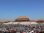
The Forbidden City is a palace complex in Dongcheng District, Beijing, China, at the center of the Imperial City of Beijing. It is surrounded by numerous opulent imperial gardens and temples including the 22 ha (54-acre) Zhongshan Park, the sacrificial Imperial Ancestral Temple, the 69 ha (171-acre) Beihai Park, and the 23 ha (57-acre) Jingshan Park. It is officially administered by the Palace Museum.

<span class="mw-page-title-main">Lhasa</span> Urban district of the City of Lhasa in Tibet

Lhasa, officially the Chengguan District of Lhasa City, is the inner urban district of Lhasa City, Tibet Autonomous Region, Southwestern China.

<span class="mw-page-title-main">Palace Museum</span> Museum in the Forbidden City, Beijing, China

The Palace Museum is a large national museum complex housed in the Forbidden City at the core of Beijing, China. With 720,000 square metres, the museum inherited the imperial royal palaces from the Ming and Qing dynasties of China and opened to the public in 1925 after the last Emperor of China was evicted.

<span class="mw-page-title-main">Potala Palace</span> Fortress in Lhasa, Tibet

The Potala Palace is a dzong fortress in Lhasa, capital of the Tibet Autonomous Region in China. It was the winter palace of the Dalai Lamas from 1649 to 1959, has been a museum since then, and a World Heritage Site since 1994.

<span class="mw-page-title-main">Ming tombs</span> Collection of mausoleums built by emperors of China

The Ming tombs are a collection of mausoleums built by the emperors of the Ming dynasty of China. The first Ming emperor's tomb is located near his capital Nanjing. However, the majority of the Ming tombs are located in a cluster near Beijing and collectively known as the Thirteen Tombs of the Ming dynasty. They are located within the suburban Changping District of Beijing Municipality, 42 kilometers (26 mi) north-northwest of Beijing's city center. The site, on the southern slope of Tianshou Mountain, was chosen based on the principles of feng shui by the third Ming emperor, the Yongle Emperor. After the construction of the Imperial Palace in 1420, the Yongle Emperor selected his burial site and created his own mausoleum. The subsequent emperors placed their tombs in the same valley.

<span class="mw-page-title-main">Purple Mountain (Nanjing)</span> Mountain in Nanjing, Jiangsu, China

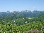
Purple Mountain or Zijin Shan is located on the eastern side of Nanjing in Jiangsu province, China. It is 448.2 metres (1,470 ft) high. Its peaks are often found enveloped in purple and golden clouds at dawn and dusk, hence its name.

<span class="mw-page-title-main">Jokhang</span> Tibetan Buddhist monastery in Lhasa, Tibet, China

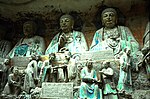
The Jokhang, also known as the Qoikang Monastery, Jokang, Jokhang Temple, Jokhang Monastery and Zuglagkang, is a Buddhist temple in Barkhor Square in Lhasa, the capital city of Tibet Autonomous Region of China. Tibetans, in general, consider this temple as the most sacred and important temple in Tibet. The temple is currently maintained by the Gelug school, but they accept worshipers from all sects of Buddhism. The temple's architectural style is a mixture of Indian vihara design, Tibetan and Nepalese design.

Imperial Tombs of the Ming and Qing Dynasties is the designation under which the UNESCO has included several tombs and burial complexes in the list of World Heritage Sites. These tombs date from the Ming and Qing dynasties of China.

<span class="mw-page-title-main">Zhao Mausoleum (Qing dynasty)</span> UNESCO World Heritage Site in Liaoning, China

Zhaoling, also known as Beiling is the tomb of the first Qing emperor, Hong Taiji, and his Empress Xiaoduanwen.

<span class="mw-page-title-main">Puning Temple (Hebei)</span> Buddhist temple in Chengde, China

The Puning Temple, commonly called the Big Buddha Temple, is a Buddhist temple complex in Chengde, Hebei province, China. It was built in 1755 during the reign of the Qianlong Emperor in the Qing dynasty. It is near the Chengde Mountain Resort and alongside the equally famed Putuo Zongcheng Temple. Puning is one of the "Eight Outer Temples" of Chengde.

<span class="mw-page-title-main">Pagoda Forest at Shaolin Temple</span> Buddhist cemetery of Shaolin Temple under Mount Song.

Pagoda Forest at Shaolin Temple refers to the main cemetery for Buddhist monks at the Shaolin Temple under Mount Song. Consisting of about 250 memorial pagodas beneath or in which the ashes of the deceased were placed, the cemetery covers about 21,000 m2. The cemetery is forested. Its name, "tower forest" (Chinese 塔林, Ta Lin) reflects that fact, whether because the pagodas are like a forest, or are in a forest. The usual English translation is "Pagoda Forest." Its center is about 250 m (270 yd) from monastery grounds.

<span class="mw-page-title-main">Fuling Mausoleum</span> Heritage site in Liaoning Province, China

The Fuling or Fu Mausoleum, also known as the East Mausoleum, is the mausoleum of Nurhaci, the founding monarch of the Later Jin dynasty and his wife, Empress Xiaocigao. It served as the main site for ritual ceremonies conducted by the imperial family during the entire Qing dynasty. Located in the eastern part of Shenyang city, Liaoning Province, northeastern China, Fuling has been a UNESCO World Heritage Site since 2004.

<span class="mw-page-title-main">Architecture of Lhasa</span>

Lhasa is noted for its historic buildings and structures related to Tibetan Buddhism. Several major architectural works have been included as UNESCO's World Heritage Sites.

<span class="mw-page-title-main">Cemetery of Confucius</span> UNESCO World Heritage Site in China

The Cemetery of Confucius is a cemetery of the Kong clan in Confucius' hometown Qufu in Shandong province. Confucius himself and some of his disciples are buried there, as well as many thousands of his descendants.

<span class="mw-page-title-main">Silk Roads: the Routes Network of Chang'an-Tianshan Corridor</span> UNESCO World Heritage Site in Central Asia

Silk Roads: The Routes Network of Chang'an-Tian Shan Corridor is a UNESCO World Heritage Site which covers the Chang'an-Tianshan portion of the ancient Silk Road and historical sites along the route. On June 22, 2014, UNESCO designated a 5,000 km stretch of the Silk Road network from Central China to the Zhetysu region of Central Asia as a World Heritage site. The corridor spans China, Kazakhstan and Kyrgyzstan and includes 33 new sites and several previously designated heritage sites.

<span class="mw-page-title-main">Baekje Historic Areas</span> UNESCO World Heritage Site in South Korea

The Baekje Historic Areas are a group of monuments located in three South Korean cities: Gongju, Buyeo, and Iksan. They relate to the last period of the Baekje Kingdom, representing the period from 475 to 660 CE, which was one of the three kingdoms that flourished from 18 BC to 660 CE. The property designated as a UNESCO World Heritage Site has eight archaeological sites. These are: The Gongsanseong fortress and the royal tombs at Songsan-ri, related to the capital city of Ungjin, now Gongju; the Busosanseong Fortress and Gwanbuk-ri administrative buildings, the Jeongnimsa Temple, the Neungsan-ri royal tombs, and the Naseong city wall in Sabi, now Buyeo; and the Wanggung-ri Palace and the Mireuksa Temple in Iksan, a subsidiary capital region of Sabi.

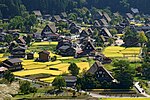
AAAAA (5A) is awarded to the most important and best-maintained tourist attractions in the People's Republic of China, given the highest level in the rating categories used by the Ministry of Culture and Tourism. As of 2020, there are 279 tourist attractions listed as 5A.

<span class="mw-page-title-main">Tomb of Chang Yuchun</span>

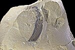
The Tomb of Chang Yuchun is the tomb of Chang Yuchun (1330–1369), a military general in late Yuan and early Ming dynasties. The tomb dates from 1369, and is located on Purple Mountain in Nanjing. There are stone horses, stone tigers, stone sheep and stone warriors in front of the tomb. It has been categorized as a "Major National Historical and Cultural Site in Jiangsu" by the State Council of China. In addition, the tomb was inscribed on the UNESCO World Heritage List in 2003 as an extension of the Imperial Tombs of the Ming and Qing Dynasties site, for its outstanding preservation and its contribution to the medieval history of China.

References

  1. "Number of World Heritage Properties by region". UNESCO . Retrieved 10 September 2011.
  2. "Composition of macro geographical (continental) regions, geographical sub-regions, and selected economic and other groupings". Geographical region and composition of each region. United Nations Statistics Division. 2010. Retrieved 20 October 2011.
  3. "World Heritage List in China". UNESCO . Retrieved 23 August 2016.
  4. "Number of World Heritage properties inscribed each Year". UNESCO . Retrieved 8 September 2011.
  5. 1 2 "The Criteria for Selection". UNESCO . Retrieved 10 September 2011.
  6. 1 2 "World Heritage List Nominations". UNESCO . Retrieved 28 May 2010.
  7. "World Heritage in Danger". UNESCO . Retrieved 28 May 2010.
  8. Taipei Times
  9. "Ancient Building Complex in the Wudang Mountains". UNESCO . Retrieved 17 Aug 2011.
  10. "Ancient City of Ping Yao". UNESCO . Retrieved 17 Aug 2011.
  11. "Ancient Villages in Southern Anhui – Xidi and Hongcun". UNESCO . Retrieved 17 Aug 2011.
  12. "Archaeological Ruins of Liangzhu City". UNESCO . Retrieved 11 Jul 2019.
  13. "Baekje Historic Areas". UNESCO . Retrieved 2 Mar 2023.
  14. "Buddhist Monuments in the Horyu-ji Area". UNESCO . Retrieved 17 Aug 2011.
  15. "Capital Cities and Tombs of the Ancient Koguryo Kingdom". UNESCO . Retrieved 17 Aug 2011.
  16. "Changdeokgung Palace Complex". UNESCO . Retrieved 17 Aug 2011.
  17. "Chengjiang Fossil Site". UNESCO . Retrieved 9 Jul 2012.
  18. "China Danxia". UNESCO . Retrieved 4 Aug 2013.
  19. "Classical Gardens of Suzhou". UNESCO . Retrieved 17 Aug 2011.
  20. "Complex of Koguryo Tombs". UNESCO . Retrieved 17 Aug 2011.
  21. "Cultural Landscape of Honghe Hani Rice Terraces". UNESCO . Retrieved 16 July 2013.
  22. "Dazu Rock Carvings". UNESCO . Retrieved 17 Aug 2011.
  23. "Fanjingshan". UNESCO . Retrieved 4 July 2018.
  24. "Fujian Tulou". UNESCO . Retrieved 17 Aug 2011.
  25. "Fujisan, sacred place and source of artistic inspiration". UNESCO . Retrieved 4 Aug 2013.
  26. "Gaya Tumuli". UNESCO . Retrieved 9 Sep 2023.
  27. "Getbol, Korean Tidal Flats". UNESCO . Retrieved 29 Jul 2021.
  28. "Gochang, Hwasun and Ganghwa Dolmen Sites". UNESCO . Retrieved 17 Aug 2011.
  29. "Gusuku Sites and Related Properties of the Kingdom of Ryukyu". UNESCO . Retrieved 17 Aug 2011.
  30. "Gyeongju Historic Areas". UNESCO . Retrieved 17 Aug 2011.
  31. "Haeinsa Temple Janggyeong Panjeon, the Depositories for the Tripitaka Koreana Woodblocks". UNESCO . Retrieved 17 Aug 2011.
  32. "Hidden Christian Sites in the Nagasaki Region". UNESCO . Retrieved 30 Jun 2018.
  33. "Himeji-jo". UNESCO . Retrieved 17 Aug 2011.
  34. "Hiraizumi – Temples, Gardens and Archaeological Sites Representing the Buddhist Pure Land". UNESCO . Retrieved 17 Aug 2011.
  35. "Hiroshima Peace Memorial (Genbaku Dome)". UNESCO . Retrieved 17 Aug 2011.
  36. "Historic Centre of Macao". UNESCO . Retrieved 17 Aug 2011.
  37. "Historic Ensemble of the Potala Palace, Lhasa". UNESCO . Retrieved 17 Aug 2011.
  38. "Decision – 24COM X.C.2 – The Potala Palace and the Jokhang Temple Monastery, Lhasa (China)". UNESCO . Retrieved 17 Aug 2011.
  39. "Decision – 25COM X.B – Historic Ensemble of the Potala Palace, Lhasa [Extension to include the Norbulingka area] (China)". UNESCO . Retrieved 17 Aug 2011.
  40. "Historic Monuments and Sites in Kaesong". UNESCO . Retrieved 4 Aug 2013.
  41. "Historic Monuments of Ancient Kyoto (Kyoto, Uji and Otsu Cities)". UNESCO . Retrieved 17 Aug 2011.
  42. "Historic Monuments of Ancient Nara". UNESCO . Retrieved 17 Aug 2011.
  43. "Historic Monuments of Dengfeng in "The Centre of Heaven and Earth"". UNESCO . Retrieved 11 Nov 2017.
  44. "Historic Villages of Korea: Hahoe and Yangdong". UNESCO . Retrieved 17 Aug 2011.
  45. "Historic Villages of Shirakawa-go and Gokayama". UNESCO . Retrieved 17 Aug 2011.
  46. "Huanglong Scenic and Historic Interest Area". UNESCO . Retrieved 17 Aug 2011.
  47. "Hwaseong Fortress". UNESCO . Retrieved 17 Aug 2011.
  48. "Imperial Palaces of the Ming and Qing Dynasties in Beijing and Shenyang". UNESCO . Retrieved 17 Aug 2011.
  49. "Imperial Tombs of the Ming and Qing Dynasties". UNESCO . Retrieved 17 Aug 2011.
  50. "DECISIONS ADOPTED BY THE 27TH SESSION OF THE WORLD HERITAGE COMMITTEE IN 2003". UNESCO . Retrieved 17 Aug 2011.
  51. "Decision – 28COM 14B.31 – Extension of Properties Inscribed on the World Heritage List (Imperial Tombs of the Ming and Qing Dynasties)". UNESCO . Retrieved 17 Aug 2011.
  52. "Itsukushima Shinto Shrine". UNESCO . Retrieved 17 Aug 2011.
  53. "Iwami Ginzan Silver Mine and its Cultural Landscape". UNESCO . Retrieved 17 Aug 2011.
  54. "Decision – 34COM 8B.53 – Cultural Properties – Examination of minor boundary modifications – Iwami Ginzan Silver Mine and its Cultural Landscape (Japan)". UNESCO . Retrieved 17 Aug 2011.
  55. "Jeju Volcanic Island and Lava Tubes". UNESCO . Retrieved 17 Aug 2011.
  56. "Jiuzhaigou Valley Scenic and Historic Interest Area". UNESCO . Retrieved 17 Aug 2011.
  57. "Jongmyo Shrine". UNESCO . Retrieved 17 Aug 2011.
  58. "Kaiping Diaolou and Villages". UNESCO . Retrieved 17 Aug 2011.
  59. Centre, UNESCO World Heritage. "Landscapes of Dauria". whc.unesco.org. Retrieved 2018-07-03.
  60. "Longmen Grottoes". UNESCO . Retrieved 17 Aug 2011.
  61. "Lushan National Park". UNESCO . Retrieved 17 Aug 2011.
  62. "Mausoleum of the First Qin Emperor". UNESCO . Retrieved 17 Aug 2011.
  63. "Migratory Bird Sanctuaries along the Coast of Yellow Sea-Bohai Gulf of China (Phase I)". UNESCO . Retrieved 11 Jul 2019.
  64. "Mogao Caves". UNESCO . Retrieved 17 Aug 2011.
  65. "Mountain Resort and its Outlying Temples, Chengde". UNESCO . Retrieved 17 Aug 2011.
  66. "Mount Emei Scenic Area, including Leshan Giant Buddha Scenic Area". UNESCO . Retrieved 17 Aug 2011.
  67. "Mount Huangshan". UNESCO . Retrieved 17 Aug 2011.
  68. "Mount Qingcheng and the Dujiangyan Irrigation System". UNESCO . Retrieved 17 Aug 2011.
  69. "Mount Sanqingshan National Park". UNESCO . Retrieved 17 Aug 2011.
  70. "Mount Taishan". UNESCO . Retrieved 17 Aug 2011.
  71. "Mount Wutai". UNESCO . Retrieved 17 Aug 2011.
  72. "Mount Wuyi". UNESCO . Retrieved 17 Aug 2011.
  73. "Mozu-Furuichi Kofun Group: Mounded Tombs of Ancient Japan". UNESCO . Retrieved 11 Jul 2019.
  74. "Namhansanseong". UNESCO . Retrieved 2 Mar 2023.
  75. "Ogasawara Islands". UNESCO . Retrieved 7 Dec 2011.
  76. "Old Town of Lijiang". UNESCO . Retrieved 17 Aug 2011.
  77. "Orkhon Valley Cultural Landscape". UNESCO . Retrieved 17 Aug 2011.
  78. "Peking Man Site at Zhoukoudian". UNESCO . Retrieved 17 Aug 2011.
  79. "Petroglyphic Complexes of the Mongolian Altai". UNESCO . Retrieved 7 Dec 2011.
  80. "Royal Tombs of the Joseon Dynasty". UNESCO . Retrieved 17 Aug 2011.
  81. "Sacred Sites and Pilgrimage Routes in the Kii Mountain Range". UNESCO . Retrieved 17 Aug 2011.
  82. "Sansa, Buddhist Mountain Monasteries in Korea". UNESCO . Retrieved 30 June 2018.
  83. "Seokguram Grotto and Bulguksa Temple". UNESCO . Retrieved 17 Aug 2011.
  84. "Seowon, Korean Neo-Confucian Academies". UNESCO . Retrieved 11 Jul 2019.
  85. "Shirakami-Sanchi". UNESCO . Retrieved 17 Aug 2011.
  86. "Shiretoko National Park". UNESCO . Retrieved 7 Dec 2011.
  87. "Shrines and Temples of Nikko". UNESCO . Retrieved 17 Aug 2011.
  88. "Sichuan Giant Panda Sanctuaries". UNESCO . Retrieved 17 Aug 2011.
  89. "Silk Road". UNESCO . Retrieved 22 June 2014.
  90. "Site of Xanadu". UNESCO . Retrieved 9 Jul 2012.
  91. "South China Karst". UNESCO . Retrieved 17 Dec 2011.
  92. "Summer Palace, an Imperial Garden in Beijing". UNESCO . Retrieved 17 Aug 2011.
  93. "Temple and Cemetery of Confucius and the Kong Family Mansion in Qufu". UNESCO . Retrieved 17 Aug 2011.
  94. "Temple of Heaven: an Imperial Sacrificial Altar in Beijing". UNESCO . Retrieved 17 Aug 2011.
  95. "The Architectural Work of Le Corbusier, an Outstanding Contribution to the Modern Movement". UNESCO . Retrieved 23 Aug 2017.
  96. "The Great Wall". UNESCO . Retrieved 17 Aug 2011.
  97. "Three Parallel Rivers of Yunnan Protected Areas". UNESCO . Retrieved 17 Aug 2011.
  98. "Decision – 34COM 8B.44 – Natural Properties – Examination of minor boundary modifications – Three Parallel Rivers of Yunnan Protected Areas (China)". UNESCO . Retrieved 17 Aug 2011.
  99. "Uvs Nuur Basin". UNESCO . Retrieved 20 October 2011.
  100. "West Lake Cultural Landscape of Hangzhou". UNESCO . Retrieved 17 Dec 2011.
  101. "Wulingyuan Scenic and Historic Interest Area". UNESCO . Retrieved 17 Aug 2011.
  102. "Xinjiang Tianshan". UNESCO . Retrieved 16 July 2013.
  103. "Yakushima". UNESCO . Retrieved 17 Aug 2011.
  104. "Yin Xu". UNESCO . Retrieved 17 Aug 2011.
  105. "Yungang Grottoes". UNESCO . Retrieved 17 Aug 2011.