List of bridges on the National Register of Historic Places in Nebraska

Last updated

This is a list of bridges and tunnels on the National Register of Historic Places in the U.S. state of Nebraska. [1]

Many of the bridges were the works of the Nebraska Department of Roads or its predecessors, including the Nebraska Bureau of Roads & Bridges. Many were registered after a study in the 1990s seeking to inventory historic bridges in Nebraska and pursuant to a Multiple Property Submission titled "Highway Bridges in Nebraska." [2] [3] [4]

NameImageBuiltListedLocationCountyType
Adamson Bridge 19161992-06-29 Valentine
42°48′26″N100°40′20″W / 42.80722°N 100.67222°W / 42.80722; -100.67222 (Adamson Bridge)
Cherry Timber stringer trestle
Ashland Bridge (Ashland, Nebraska) Ashland bridge from NE.JPG 19361992-06-29 Ashland
41°02′04″N96°22′01″W / 41.034444°N 96.366944°W / 41.034444; -96.366944 (Ashland Bridge)
Saunders Warren pony truss, one of two surviving in Nebraska
Beal Slough Bridge 19371992-06-29 Lincoln
40°46′13″N96°42′46″W / 40.77028°N 96.71278°W / 40.77028; -96.71278 (Beal Slough Bridge)
Lancaster Concrete rigid frame bridge
Bell Bridge Bell Bridge (Niobrara River) 1.JPG 19031992-06-29 Valentine
42°53′42″N100°19′20″W / 42.89500°N 100.32222°W / 42.89500; -100.32222 (Bell Bridge)
Cherry Pratt through truss
Berry State Aid Bridge Berry Bridge (Niobrara River) from US 3.JPG 1920, 19211992-06-29 Valentine
42°54′7″N100°21′44″W / 42.90194°N 100.36222°W / 42.90194; -100.36222 (Berry State Aid Bridge)
Cherry Pratt through truss
Big Blue River Bridge (Surprise, Nebraska) Big Blue bridge (Butler County) from SW 1.JPG 1897, 18981992-06-29 Surprise
41°6′3″N97°17′28″W / 41.10083°N 97.29111°W / 41.10083; -97.29111 (Big Blue River Bridge)
Butler Pin-connected Pratt truss
Big Blue River Bridge (Grafton, Nebraska) Big Blue River Bridge 5.jpg 19181992-06-29 Grafton
40°41′47″N97°43′44″W / 40.69639°N 97.72889°W / 40.69639; -97.72889 (Big Blue River Bridge)
Fillmore Concrete spandrel arch
Big Indian Creek Bridge 19031992-06-29 Wymore
40°5′13″N96°43′22″W / 40.08694°N 96.72278°W / 40.08694; -96.72278 (Big Indian Creek Bridge)
Gage Warren pony truss
Big Papillion Creek Bridge ca. 19401992-06-29 La Vista
41°10′27″N96°6′1″W / 41.17417°N 96.10028°W / 41.17417; -96.10028 (Big Papillion Creek Bridge)
Sarpy Tied arch pony truss
Bloody Run Bridge 18981992-06-29 Virginia
40°12′39″N96°33′29″W / 40.21083°N 96.55806°W / 40.21083; -96.55806 (Bloody Run Bridge)
Gage Warren pony truss
Borman Bridge Borman Bridge (Niobrara River) from SE 2.JPG 19161992-06-29 Valentine
42°51′7″N100°31′15″W / 42.85194°N 100.52083°W / 42.85194; -100.52083 (Borman Bridge)
Cherry Pratt through truss
Brewer Bridge Brewer Bridge.JPG 1899, 19211992-06-29 Valentine
42°52′34″N100°15′58″W / 42.87611°N 100.26611°W / 42.87611; -100.26611 (Brewer Bridge)
Cherry Pratt through truss
Bridge Nebraska City concrete arch bridge 5.JPG 19121992-06-29 Nebraska City
40°39′39″N95°52′41″W / 40.66083°N 95.87806°W / 40.66083; -95.87806 (Bridge)
Otoe Concrete spandrel arch
Bridge 18761992-06-29 Lorton
40°34′1″N96°5′26″W / 40.56694°N 96.09056°W / 40.56694; -96.09056 (Bridge)
Otoe Bowstring pony arch-truss
Bridge 19111992-06-29 Royal
42°24′50″N98°4′2″W / 42.41389°N 98.06722°W / 42.41389; -98.06722 (Bridge)
Antelope Kingpost pony truss
Mynard Road Bridge Mynard Road Bridge1.jpg ca. 19001992-06-29 Louisville
40°58′22″N96°4′55″W / 40.97278°N 96.08194°W / 40.97278; -96.08194 (Bridge)
Cass Warren truss leg bedstead
Bridge 18981992-06-29 Wymore
40°9′6″N96°47′3″W / 40.15167°N 96.78417°W / 40.15167; -96.78417 (Bridge)
Gage Warren pony truss
Bridge Ideal Cement bridge from S.jpg 19081992-06-29 Stratton
40°9′7″N101°11′29″W / 40.15194°N 101.19139°W / 40.15194; -101.19139 (Bridge)
Hitchcock Reinforced concrete slab
Brownson Viaduct 19421992-06-29 Brownson
41°11′22″N103°7′17″W / 41.18944°N 103.12139°W / 41.18944; -103.12139 (Brownson Viaduct)
Cheyenne Timber stringer trestle
Brownville Bridge Brownville-bridge.jpg 19391993-06-17 Brownville
40°23′57″N95°39′6″W / 40.39917°N 95.65167°W / 40.39917; -95.65167 (Brownville Bridge)
Nemaha
Bryan Bridge Bryan Bridge in Nebraska.JPG 19321988-06-23 Valentine
42°49′56″N100°31′41″W / 42.83222°N 100.52806°W / 42.83222; -100.52806 (Bryan Bridge)
Cherry Pin-connected arch bridge
Burwell Bridge Burwell, Nebraska Hwy 11 bridge from SW 3.JPG 1940, 19411992-06-29 Burwell
41°46′4″N99°7′31″W / 41.76778°N 99.12528°W / 41.76778; -99.12528 (Burwell Bridge)
Garfield Steel stringer bridge
Cambridge State Aid Bridge Cambridge Republican bridge from NW.JPG 19141992-06-29 Cambridge
40°16′25″N100°9′56″W / 40.27361°N 100.16556°W / 40.27361; -100.16556 (Cambridge State Aid Bridge)
Furnas Spandrel arch bridge
Camp Clarke Bridge Site Camp Clarke bridge site view from N.JPG 1875, 18801974-11-08 Bridgeport Morrill
Carns State Aid Bridge Carns bridge from SW 3.JPG 1912, 19131992-06-29 Bassett
42°44′1″N99°28′52″W / 42.73361°N 99.48111°W / 42.73361; -99.48111 (Carns State Aid Bridge)
Rock Parker & Pratt through truss
Cincinnati Bridge 1879, 18801992-06-29 Du Bois
40°0′47″N96°2′40″W / 40.01306°N 96.04444°W / 40.01306; -96.04444 (Cincinnati Bridge)
Pawnee Bowstring through arch truss
Clear Creek Bridge Butler County Clear Creek bridge from W.JPG 1891, 19281992-06-29 Bellwood
41°23′3″N97°20′6″W / 41.38417°N 97.33500°W / 41.38417; -97.33500 (Clear Creek Bridge)
Butler Warren through truss
Colclesser Bridge 1888, 1933, 19341992-06-29 Rushville
42°33′3″N102°29′9″W / 42.55083°N 102.48583°W / 42.55083; -102.48583 (Colclesser Bridge)
Sheridan Baltimore through truss
Columbus Doo Doo River Bridge Columbus Loup River Bridge from NW 1.JPG 1932, 19331992-06-29 Columbus
41°25′1″N97°22′4″W / 41.41694°N 97.36778°W / 41.41694; -97.36778 (Columbus Loup River Bridge)
Platte Parker through truss
Deering Bridge Deering Bridge 3.jpg 19161992-06-29 Sutton
40°38′26″N97°49′27″W / 40.64056°N 97.82417°W / 40.64056; -97.82417 (Deering Bridge)
Clay
Fillmore
Concrete spandrel arch
DeWitt Flour Mills and King Iron Bridge ca. 1888, 1911, 19201978-12-27 DeWitt Gage Pratt Through Truss
Elkhorn River Bridge Old Elkhorn River bridge at 519 Av from W 2.JPG 1883, 19291992-06-29 Clearwater
42°9′36″N98°7′33″W / 42.16000°N 98.12583°W / 42.16000; -98.12583 (Elkhorn River Bridge)
Antelope Bowstring through arch-truss
Franklin Bridge Franklin Bridge (Nebraska) from SE.JPG 1932, 19351992-06-29 Franklin
40°4′33″N98°57′8″W / 40.07583°N 98.95222°W / 40.07583; -98.95222 (Franklin Bridge)
Franklin Warren pony truss
Gross State Aid Bridge Gross State Aid Bridge from SW 3.JPG 19181992-06-29 Verdigre
42°39′16″N98°2′34″W / 42.65444°N 98.04278°W / 42.65444; -98.04278 (Gross State Aid Bridge)
Knox Parker through truss
Henry State Aid Bridges Henry State Aid bridges N bridge from SW.JPG 19191992-06-29 Henry
41°59′50″N104°2′50″W / 41.99722°N 104.04722°W / 41.99722; -104.04722 (Henry State Aid Bridges)
Scotts Bluff Concrete spandrel arch
Hoyt Street Bridge ca. 1870, 18901992-06-29 Beatrice
40°16′39″N96°46′40″W / 40.27750°N 96.77778°W / 40.27750; -96.77778 (Hoyt Street Bridge)
Gage Bowstring through arch-truss
Interstate Canal Bridge Interstate Canal (Scotts Bluff County) old bridge 2.JPG ca. 19151992-06-29 Scottsbluff
41°59′50″N103°38′18″W / 41.99722°N 103.63833°W / 41.99722; -103.63833 (Interstate Canal Bridge)
Scotts Bluff Pratt pony truss
Keim Stone Arch Bridge Keim Stone Arch Bridge from SW 2.JPG 19161992-06-29 Tecumseh
40°23′32″N96°7′22″W / 40.39222°N 96.12278°W / 40.39222; -96.12278 (Keim Stone Arch Bridge)
Johnson Limestone arch
Kilgore Bridge Kilgore Bridge 1.jpg 19151992-06-29 Kearney
40°41′2″N98°57′3″W / 40.68389°N 98.95083°W / 40.68389; -98.95083 (Kilgore Bridge)
Buffalo Pratt pony truss
Lewellen State Aid Bridge Lewellen, Nebraska bridge from S 4.JPG 1926, 19271992-06-29 Lewellen
41°19′3″N102°8′34″W / 41.31750°N 102.14278°W / 41.31750; -102.14278 (Lewellen State Aid Bridge)
Garden Pratt pony truss
Lewis Bridge Keya Paha Lewis Bridge from US 1.JPG 19221992-06-29 Springview
42°59′53″N99°38′8″W / 42.99806°N 99.63556°W / 42.99806; -99.63556 (Lewis Bridge)
Keya Paha Pratt pony truss
Lisco State Aid Bridge Lisco bridge from S 2.JPG 1927, 19281992-06-29 Lisco
41°29′22″N102°37′30″W / 41.48944°N 102.62500°W / 41.48944; -102.62500 (Lisco State Aid Bridge)
Garden Pratt pony truss
Little Nemaha River Bridge (Dunbar, Nebraska) 18741992-06-29 Dunbar
40°40′57″N96°2′42″W / 40.68250°N 96.04500°W / 40.68250; -96.04500 (Little Nemaha River Bridge)
Otoe Bowstring pony arch-truss
Loosveldt Bridge 1888, 1933, 19341992-06-29 Rushville
42°34′53″N102°23′2″W / 42.58139°N 102.38389°W / 42.58139; -102.38389 (Loosveldt Bridge)
Sheridan Baltimore through truss
Main Street Bridge 1915, 19201992-06-29 Elkhorn
41°16′54″N96°14′14″W / 41.28167°N 96.23722°W / 41.28167; -96.23722 (Main Street Bridge)
Douglas Steel stringer bridge
Meridian Bridge Meridian Bridge.jpg 19241993-06-17 South Yankton
42°51′35″N97°23′37″W / 42.85972°N 97.39361°W / 42.85972; -97.39361 (Meridian Bridge)
Cedar Prat vertical-lift truss
Mission Creek Bridge 18981992-06-29 Barneston
40°0′15″N96°27′48″W / 40.00417°N 96.46333°W / 40.00417; -96.46333 (Mission Creek Bridge)
Gage Warren pony truss
Neligh Mill Bridge Neligh Mill Bridge from SW.JPG 19101992-06-29 Neligh
42°7′32″N98°1′51″W / 42.12556°N 98.03083°W / 42.12556; -98.03083 (Neligh Mill Bridge)
Antelope Pratt through truss
Nine Bridges Bridge Nine Bridges pier.jpg 19131992-06-29 Doniphan
40°49′40″N98°22′47″W / 40.82778°N 98.37972°W / 40.82778; -98.37972 (Nine Bridges Bridge)
Hall Pratt half-hip pony truss
Niobrara River Bridge Niobrara State Park bridge from NW 2.JPG 19291992-11-12 Niobrara
42°45′53″N98°2′39″W / 42.76472°N 98.04417°W / 42.76472; -98.04417 (Niobrara River Bridge)
Knox Warren through truss
North Loup Bridge North Loup bridge (806 Rd) from SW 2.JPG 19121992-06-29 North Loup
41°30′38″N98°45′4″W / 41.51056°N 98.75111°W / 41.51056; -98.75111 (North Loup Bridge)
Valley Pratt through truss
North Omaha Creek Bridge North Omaha Creek Bridge 26 Rd from S.JPG ca. 19051992-06-29 Winnebago
42°11′38″N96°31′50″W / 42.19389°N 96.53056°W / 42.19389; -96.53056 (North Omaha Creek Bridge)
Thurston Pin-connected Pratt truss
Olive Branch Bridge 18971992-06-29 Sprague
40°36′37″N96°46′27″W / 40.61028°N 96.77417°W / 40.61028; -96.77417 (Olive Branch Bridge)
Lancaster Warren truss leg bedstead
Plattsmouth Bridge Plattsmouth-bridge.jpg 19291993-04-15 Plattsmouth
41°0′2″N95°51′58″W / 41.00056°N 95.86611°W / 41.00056; -95.86611 (Plattsmouth Bridge)
Cass Cantlevered through truss
Ponca Creek Bridge 19041992-06-29 Lynch
42°49′27″N98°24′24″W / 42.82417°N 98.40667°W / 42.82417; -98.40667 (Ponca Creek Bridge)
Boyd Pratt half-hip pony truss
Prairie Dog Creek Bridge Prairie Dog Creek Bridge 5.jpg 19131992-06-29 Orleans
40°0′16″N99°28′48″W / 40.00444°N 99.48000°W / 40.00444; -99.48000 (Prairie Dog Creek Bridge)
Harlan Camelback pony truss
Rattlesnake Creek Bridge Rattlesnake Creek Bridge from SW.JPG 19031992-06-29 Bancroft
42°2′39″N96°36′48″W / 42.04417°N 96.61333°W / 42.04417; -96.61333 (Rattlesnake Creek Bridge)
Cuming Pratt half-hip pony truss
Red Cloud Bridge Red Cloud Republican bridge from NW.JPG 19351992-06-29 Red Cloud
40°3′46″N98°31′7″W / 40.06278°N 98.51861°W / 40.06278; -98.51861 (Red Cloud Bridge)
Webster Warren pony/through truss
Republican River Bridge Farmers Bridge 1.jpg 19111992-06-29 Riverton
40°4′10″N98°44′38″W / 40.06944°N 98.74389°W / 40.06944; -98.74389 (Republican River Bridge)
Franklin Pratt through truss
Roscoe State Aid Bridge Roscoe, Nebraska bridge from SW 2.jpg 1934, 19351992-06-29 Roscoe
41°7′33″N101°34′35″W / 41.12583°N 101.57639°W / 41.12583; -101.57639 (Roscoe State Aid Bridge)
Keith Steel cantilevered stringer
Rulo Bridge Rulo-bridge.jpg 1938, 19391993-01-04 Rulo
40°3′14″N95°25′14″W / 40.05389°N 95.42056°W / 40.05389; -95.42056 (Rulo Bridge)
Richardson Pennsylvania through truss
Saddle Creek Underpass Saddle Creek Underpass.jpg 19341992-06-29 Omaha
41°15′35″N95°58′49″W / 41.25972°N 95.98028°W / 41.25972; -95.98028 (Saddle Creek Underpass)
Douglas Concrete rigid frame bridge
Sappa Creek Bridge Sappa Creek Bridge 2.jpg 19161992-06-29 Stamford
40°7′53″N99°33′17″W / 40.13139°N 99.55472°W / 40.13139; -99.55472 (Sappa Creek Bridge)
Harlan Pratt pony truss
Sargent Bridge Sargent bridge from S.JPG 19081992-06-29 Sargent
41°37′38″N99°22′18″W / 41.62722°N 99.37167°W / 41.62722; -99.37167 (Sargent Bridge)
Custer Pratt through truss
South Omaha Bridge South-omaha-bridge.jpg 1933–19351992-06-29 Omaha
41°12′47″N95°55′57″W / 41.21306°N 95.93250°W / 41.21306; -95.93250 (South Omaha Bridge)
Douglas Warren through truss
Stewart Bridge 19151992-06-29 Oak
40°21′2″N97°52′38″W / 40.35056°N 97.87722°W / 40.35056; -97.87722 (Stewart Bridge)
Nuckolls Concrete spandrel arch
Sutherland State Aid Bridge Sutherland State Aid Bridge N half from W.jpg 1914, 19151992-06-29 Sutherland
41°12′41″N100°59′51″W / 41.21139°N 100.99750°W / 41.21139; -100.99750 (Sutherland State Aid Bridge)
Lincoln Concrete spandrel arch
Sweetwater Mill Bridge Sweetwater bridge from S 2.JPG 19091992-06-29 Sweetwater
41°2′27″N99°0′27″W / 41.04083°N 99.00750°W / 41.04083; -99.00750 (Sweetwater Mill Bridge)
Buffalo Pratt pony truss
Tekamah City Bridge Tekamah City Bridge DS 1.JPG 19341992-06-29 Tekamah
41°46′36″N96°13′15″W / 41.77667°N 96.22083°W / 41.77667; -96.22083 (Tekamah City Bridge)
Burt Concrete rigid frame bridge
Turkey Creek Bridge Turkey Creek Bridge 4.jpg 18991992-06-29 Ragan
40°17′33″N99°19′57″W / 40.29250°N 99.33250°W / 40.29250; -99.33250 (Turkey Creek Bridge)
Harlan Pin-connected Pratt truss
Twin Bridge (Brownlee, Nebraska) Twin Bridge (Cherry Co, NE) from S bank 3.JPG 19001992-06-29 Brownlee
42°20′0″N100°45′43″W / 42.33333°N 100.76194°W / 42.33333; -100.76194 (Twin Bridge)
Cherry Steel stringer bridge
Verdigris Creek Bridge Verdigris Creek Bridge (520 Ave) E truss from NW 3.JPG ca. 19181992-06-29 Royal
42°21′31″N98°6′23″W / 42.35861°N 98.10639°W / 42.35861; -98.10639 (Verdigris Creek Bridge)
Antelope Kingpost pony truss
Willow Creek Bridge Willow Creek Bridge, Gilman Park, Pierce, Nebraska from SW.JPG 19131992-06-29 Foster
42°10′38″N97°40′1″W / 42.17722°N 97.66694°W / 42.17722; -97.66694 (Willow Creek Bridge)
Pierce Lattice pony truss
Wolf Creek Bridge 18891992-06-29 Dunbar
40°47′2″N95°54′57″W / 40.78389°N 95.91583°W / 40.78389; -95.91583 (Wolf Creek Bridge)
Otoe Pratt through truss
Wyoming Bridge 18781992-06-29 Dunbar
40°44′43″N95°53′32″W / 40.74528°N 95.89222°W / 40.74528; -95.89222 (Wyoming Bridge)
Otoe Bowstring pony arch-truss
York Subway York Subway 4.jpg 1938, 19391992-06-29 York
40°52′27″N97°35′34″W / 40.87417°N 97.59278°W / 40.87417; -97.59278 (York Subway)
York Concrete rigid frame bridge
Little Nemaha River Bridge (Syracuse, Nebraska) 19011992-06-29
removed 2012-12-19
Syracuse
40°40′0″N96°14′9″W / 40.66667°N 96.23583°W / 40.66667; -96.23583 (Little Nemaha River Bridge)
Otoe Pratt pony truss

See also

Related Research Articles

<span class="mw-page-title-main">United States National Register of Historic Places listings</span> Register for landmarks in the United States

The National Register of Historic Places in the United States is a register including buildings, sites, structures, districts, and objects. The Register automatically includes all National Historic Landmarks as well as all historic areas administered by the U.S. National Park Service. Since its introduction in 1966, more than 90,000 separate listings have been added to the register.

<span class="mw-page-title-main">National Register of Historic Places listings in Oregon</span>

This is a list of properties and historic districts in Oregon that are listed on the National Register of Historic Places. There are listings in all of Oregon's 36 counties.

<span class="mw-page-title-main">Nebraska Department of Roads</span>

The Nebraska Department of Roads (NDOR) was the state government agency charged with building and maintaining the state and federal highways in the U.S. State of Nebraska from 1957 to 2017. The main headquarters of the agency was located in Lincoln, the capital city. At the time of its dissolution, there were eight NDOR district offices located across the state. Since 2017 the NDOR merged with the Nebraska Department of Aeronautics and is now a part of the Nebraska Department of Transportation.

The Nebraska Department of Transportation (NDOT) is the state government agency charged with building and maintaining the state highways in the U.S. state of Nebraska, as well as the state's airports. The main headquarters of the agency is located in Lincoln, the capital city. There are currently eight NDOT district offices located across the state.

<span class="mw-page-title-main">Nebraska State Highway System</span>

The Nebraska State Highway System consists of all the state highways in Nebraska maintained by the Nebraska Department of Roads. This includes federally designated Interstates and US Highways as well as state highways, links and spurs. The system comprises 9,942 miles (16,000 km) of state highways in all 93 counties. Highways within the system range in scale and quality from 10-lane urban freeways, such as I-80 around Omaha, to standard two-lane rural undivided highways as well as 39 miles (63 km) of state highways that remain unpaved such as N-67 north of Dunbar. Surrounding landscapes along the highway system range from the urban areas in Omaha and Lincoln to scenic journeys through uninhabited grasslands in the Nebraska Sandhills.

<span class="mw-page-title-main">Interstate 80 in Nebraska</span> Highway in Nebraska

Interstate 80 (I-80) in the US state of Nebraska runs east from the Wyoming state border across the state to Omaha. Construction of the stretch of I-80 spanning the state was completed on October 19, 1974. Nebraska was the first state in the nation to complete its mainline Interstate Highway System.

<span class="mw-page-title-main">Meridian Highway Bridge</span> Bridge in South Dakota and Cedar County, Nebraska

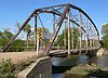
The Meridian Highway Bridge is a bridge that formerly carried U.S. Route 81 across the Missouri River between Nebraska and South Dakota. The Meridian Highway Bridge connects Yankton, South Dakota with rural Cedar County, Nebraska. The Meridian Bridge is a double-deck bridge, with the top level having carried traffic into South Dakota from Nebraska, and the lower level having carried traffic into Nebraska from South Dakota. It was closed to all traffic in 2008, but reopened for use only by pedestrians and bicycles in 2011.

<span class="mw-page-title-main">Lincoln Highway (Omaha)</span>

The Lincoln Highway in Omaha, Nebraska, runs east–west from near North 183rd Street and West Dodge Road in Omaha, Nebraska, towards North 192nd Street outside of Elkhorn. This section of the Lincoln Highway, one of only 20 miles (32 km) that were paved with brick in Nebraska, is one of the most well-preserved in the country. The roadway was listed on the National Register of Historic Places in 1984. The Lincoln Highway was the first road across the United States, traversing coast-to-coast from Times Square in New York City to Lincoln Park in San Francisco, California.

<span class="mw-page-title-main">Transportation in Omaha</span>

Transportation in Omaha, Nebraska, includes most major modes, such as pedestrian, bicycle, automobile, bus, train and airplane. While early transportation consisted of ferries, stagecoaches, steamboats, street railroads, and railroads, the city's transportation systems have evolved to include the Interstate Highway System, parklike boulevards and a variety of bicycle and pedestrian trails. The historic head of several important emigrant trails and the First transcontinental railroad, its center as a national transportation hub earned Omaha the nickname "Gate City of the West" as early as the 1860s.

The South Dakota Department of Transportation (SDDOT) is a state government organization in charge of maintaining public roadways of the U.S. state of South Dakota. South Dakota has 82,447 miles of highways, roads and streets, as well as 5,905 bridges. The SDDOT is responsible for 7,830 miles of the roadway system.

Franklin Bridge is a bridge in Franklin County, Nebraska. The road bridge was built over the Republican River in 1932 and features Warren pony trusses. In 1935, a flood swept away one truss and one approach span. The bridge was listed on the National Register of Historic Places in 1992, and was delisted in 2020.

Dodge Street is the main east–west street in Omaha, Nebraska. Numbered as U.S. Route 6 (US 6), the street starts in Downtown Omaha and connects to West Dodge Road just west of 78th Street. From there, it continues westward through the remainder of Douglas County.

<span class="mw-page-title-main">Western Bridge and Construction Company</span>

The Western Bridge and Construction Company, located in Omaha, Nebraska, was one of the foremost bridge engineering and manufacturing companies in the Midwestern United States. Several of their bridges are now listed on the National Register of Historic Places. Their headquarters were located in the Bee Building in Downtown Omaha.

<span class="mw-page-title-main">Lisco State Aid Bridge</span> United States historic place

The Lisco State Aid Bridge is located on a county road over the North Platte River south of Lisco, Nebraska. Completed in 1928, the bridge today "is distinguished as an important crossing of the Platte River and one of the last two intact multiple-span state aid truss bridges" in Nebraska.

<span class="mw-page-title-main">U.S. Route 64 in Arkansas</span>

U.S. Route 64 is a U.S. highway running from Teec Nos Pos, Arizona east to Nags Head, North Carolina. In the U.S. state of Arkansas, the route runs 246.35 miles (396.46 km) from the Oklahoma border in Fort Smith east to the Tennessee border in Memphis. The route passes through several cities and towns, including Fort Smith, Clarksville, Russellville, Conway, Searcy, and West Memphis. US 64 runs parallel to Interstate 40 until Conway, when I-40 takes a more southerly route.

<span class="mw-page-title-main">AJX Bridge over South Fork and Powder River</span> United States historic place

The AJX Bridge is a historic Pratt truss bridge in southwestern Johnson County, Wyoming. The bridge was built in 1931 across the South Fork of the Powder River near Kaycee, Wyoming. AJX Bridge was built to provide a river crossing for U.S. Route 87. It was placed on the National Register of Historic Places in 1985 as part of a Multiple Property Submission devoted to historic bridges in Wyoming.

<span class="mw-page-title-main">Lincoln Construction Co.</span>

The Lincoln Construction Company was an American construction company in Nebraska. The company built several bridges in Nebraska between 1913 and 1916. A state engineer, after inspecting one of the company's bridge, found that "the workmanship as a whole was decidedly poor" and recommended suspending all payments on the bridge until the "poor appearance" was remedied. Company president, W.S. Collett, stated that the company's experience in the bridge business had been "more or less disastrous, from a financial point... which leads me to the conclusion that I had better quit while my credit remains good."

<span class="mw-page-title-main">Big Blue River Bridge (Grafton, Nebraska)</span> United States historic place

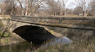
The Big Blue River Bridge is a National Register of Historic Places-listed bridge located in Fillmore County, Nebraska, near the village of Grafton. The bridge is one of two listed on the Register within Fillmore County, the other being the Deering Bridge. The bridge is a single-span, concrete, spandrel arch facility. The site was first designed by state engineers in 1917, and was constructed in 1918. At the time of the construction, the facility's architectural style was the main bridge design in the state. The bridge still retains all original building materials, and has only undergone slight maintenance since construction. The bridge carries Fillmore County Road 6 over the West Fork of the Big Blue River.

<span class="mw-page-title-main">Sargent Bridge</span> United States historic place

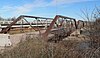
Sargent Bridge was a Pratt through truss steel bridge that spanned the Middle Loup River near Sargent, Nebraska. In 1992, it was listed in the National Register of Historic Places, as one of the few remaining steel truss bridges constructed in Nebraska during the early 20th century. It was destroyed by flooding in 2019, and was delisted in 2020.

References

Map all coordinates using: OpenStreetMap
  1. "National Register Information System". National Register of Historic Places . National Park Service. July 9, 2010.
  2. Highway Bridges in Nebraska MPS
  3. "Historic Preservation". Nebraska Department of Roads.
  4. "National Register Evaluation of Nebraska Bridges 1947 to 1965" (PDF). Mead Hunt for Nebraska Department of Roads. May 2007.