List of cities and largest towns in Myanmar

Last updated

The following is a list of cities and largest towns in Myanmar with populations above 5,000, according to UNFPA Myanmar. [1] The capitals of states and regions in Myanmar are bolded. Myanmar - Location Map (2013) - MMR - UNOCHA.svg

Contents

An enlargeable map of Myanmar. Un-myanmar.png
An enlargeable map of Myanmar.
An ethnolinguistic map of Burma. Ethnolinguistic map of Burma 1972 en.svg
An ethnolinguistic map of Burma.

List of cities by urban population

RankCityState/Region2014 Census2019 EstimateChange
1 Yangon Flag of Yangon Region.svg  Yangon Region 5,160,5123,361,741−34.86%
2 Mandalay Flag of Mandalay Region.svg  Mandalay Region 1,319,452885,287−32.90%
3 Naypyidaw Naypyidaw Union Territory 375,189375,1890.00%
4 Mawlamyine Flag of Mon State (2018).svg  Mon State 231,894307,615+32.65%
5 Taunggyi Flag of the Shan State.svg  Shan State 304,253131,483−56.78%
6 Bago Flag of Bago Region.png  Bago Region 220,487190,930−13.41%
7 Monywa Flag of Sagaing Region (2019).svg  Sagaing Region 201,446138,576−31.21%
8 Myitkyina Flag of Kachin State.svg  Kachin State 180,49171,320−60.49%
9 Pathein Flag of Ayeyarwady Region.svg  Ayeyarwady Region 172,923183,903+6.35%
10 Sittwe Flag of Rakhine.svg  Rakhine State 124,679137,608+10.37%
11 Pyay Flag of Bago Region.png  Bago Region 123,247105,698−14.24%
12 Pakokku Flag of Magway Region.svg  Magway Region 107,55790,783−15.60%
13 Myeik Flag of Tanintharyi Region (2010-2021).svg  Tanintharyi Region 107,185122,670+14.45%
14 Meiktila Flag of Mandalay Region.svg  Mandalay Region 102,405129,674+26.63%
15 Taungoo Flag of Bago Region.png  Bago Region 98,82283,538−15.47%
16 Myingyan Flag of Mandalay Region.svg  Mandalay Region 91,542103,555+13.12%
17 Mogok Flag of Mandalay Region.svg  Mandalay Region 89,85566,374−26.13%
18 Magway Flag of Magway Region.svg  Magway Region 84,75472,388−14.59%
19 Hinthada Flag of Ayeyarwady Region.svg  Ayeyarwady Region 80,956104,660+29.28%
20 Sagaing Flag of Sagaing Region (2019).svg  Sagaing Region 79,94459,937−25.03%
21 Thanlyin Flag of Yangon Region.svg  Yangon Region 79,52656,654−28.76%
22 Dawei Flag of Tanintharyi Region (2010-2021).svg  Tanintharyi Region 73,47096,755+31.69%
23 Nyaunglebin Flag of Bago Region.png  Bago Region 72,87370,008−3.93%
24 Shwebo Flag of Sagaing Region (2019).svg  Sagaing Region 72,33767,684−6.43%
25 Bhamo Flag of Kachin State.svg  Kachin State 54,71139,092−28.55%
26 Aunglan Flag of Magway Region.svg  Magway Region 52,86543,223−18.24%
27 Yenangyaung Flag of Magway Region.svg  Magway Region 49,58890,845+83.20%
28 Bogale Flag of Ayeyarwady Region.svg  Ayeyarwady Region 48,33553,462+10.61%
29 Minbu Flag of Magway Region.svg  Magway Region 39,88442,809+7.33%
30 Hlegu Flag of Yangon Region.svg  Yangon Region 38,75720,675−46.65%
31 Tharrawaddy Flag of Bago Region.png  Bago Region 38,11642,478+11.44%
32 Hakha Flag of Chin State.svg  Chin State 27,65410,699−61.31%
33 Thayet Flag of Magway Region.svg  Magway Region 20,27846,361+128.63%

List of towns by urban population

RankTownState/Region2014 Census1993 EstimateChange
1 Lashio Flag of the Shan State.svg  Shan State 144,031107,604+33.85%
2 Pyin Oo Lwin Flag of Mandalay Region.svg  Mandalay Region 128,78385,712+50.25%
3 Kalay Flag of Sagaing Region (2019).svg  Sagaing Region 120,50668,259+76.54%
4 Myawaddy Flag of Kayin State.svg  Kayin State 113,155113,1550.00%
5 Taikkyi Flag of Yangon Region.svg  Yangon Region 88,00088,0000.00%
6 Hpa-An Flag of Kayin State.svg  Kayin State 75,14175,1410.00%
7 Muse Flag of the Shan State.svg  Shan State 74,31374,3130.00%
8 Pyinmana Naypyidaw Union Territory 72,01072,0100.00%
9 Pyu Flag of Bago Region.png  Bago Region 63,88032,946+93.89%
10 Hpakant Flag of Kachin State.svg  Kachin State 60,12360,1230.00%
11 Myaungmya Flag of Ayeyarwady Region.svg  Ayeyarwady Region 58,69858,6980.00%
12 Shwegu Flag of Kachin State.svg  Kachin State 58,69658,6960.00%
13 Kawthaung Flag of Tanintharyi Region (2010-2021).svg  Tanintharyi Region 57,94957,9490.00%
14 Kalaw Flag of the Shan State.svg  Shan State 57,79757,7970.00%
15 Thanbyuzayat Flag of Mon State (2018).svg  Mon State 57,20857,2080.00%
16 Thaton Flag of Mon State (2018).svg  Mon State 55,04786,413−36.30%
17 Mudon Flag of Mon State (2018).svg  Mon State 52,51462,222−15.60%
18 Tachileik Flag of the Shan State.svg  Shan State 51,55351,5530.00%
19 Loikaw Flag of Kayah State.svg  Kayah State 51,34951,3490.00%
20 Pyapon Flag of Ayeyarwady Region.svg  Ayeyarwady Region 49,12850,874−3.43%
21 Nyaung-U Flag of Mandalay Region.svg  Mandalay Region 48,52848,5280.00%
22 Taungdwingyi Flag of Magway Region.svg  Magway Region 46,02352,330−12.05%
23 Chauk Flag of Magway Region.svg  Magway Region 45,07667,845−33.56%
24 Kengtung Flag of the Shan State.svg  Shan State 44,28957,022−22.33%
25 Tamu Flag of Sagaing Region (2019).svg  Sagaing Region 43,73743,7370.00%
26 Ma-ubin Flag of Ayeyarwady Region.svg  Ayeyarwady Region 43,11142,047+2.53%
27 Twante Flag of Yangon Region.svg  Yangon Region 43,09237,947+13.56%
28 Kawkareik Flag of Kayin State.svg  Kayin State 42,95042,9500.00%
29 Kyaukpadaung Flag of Mandalay Region.svg  Mandalay Region 42,81742,8170.00%
30 Kyauktan Flag of Yangon Region.svg  Yangon Region 42,77842,7780.00%
31 Tatkon Naypyidaw Union Territory 41,68341,6830.00%
32 Kyaukse Flag of Mandalay Region.svg  Mandalay Region 41,48237,207+11.49%
33 Kyaukme Flag of the Shan State.svg  Shan State 39,93039,9300.00%
34 Daik-U Flag of Bago Region.png  Bago Region 38,47738,4770.00%
35 Mrauk U Flag of Rakhine.svg  Rakhine State 36,13936,1390.00%
36 Kyaikto Flag of Mon State (2018).svg  Mon State 35,22439,694−11.26%
37 Ye Flag of Mon State (2018).svg  Mon State 34,43038,838−11.35%
38 Tangyan Flag of the Shan State.svg  Shan State 33,60333,6030.00%
39 Mohnyin Flag of Kachin State.svg  Kachin State 33,29033,2900.00%
40 Kayan Flag of Yangon Region.svg  Yangon Region 32,97732,894+0.25%
41 Mawlamyinegyun Flag of Ayeyarwady Region.svg  Ayeyarwady Region 32,91531,909+3.15%
42 Wundwin Flag of Mandalay Region.svg  Mandalay Region 32,55832,5580.00%
43 Pyawbwe Flag of Mandalay Region.svg  Mandalay Region 32,21432,2140.00%
44 Tanai Flag of Kachin State.svg  Kachin State 31,99831,9980.00%
45 Kyauktaga Flag of Bago Region.png  Bago Region 31,65631,6560.00%
46 Labutta Flag of Ayeyarwady Region.svg  Ayeyarwady Region 31,17434,074−8.51%
47 Aungpan Flag of the Shan State.svg  Shan State 30,31330,3130.00%
48 Namhkan Flag of the Shan State.svg  Shan State 30,26930,2690.00%
49 Lewe Naypyidaw Union Territory 30,20830,2080.00%
50 Lawksawk Flag of the Shan State.svg  Shan State 29,53329,5330.00%
51 Paung Flag of Mon State (2018).svg  Mon State 29,43429,4340.00%
52 Taungup Flag of Rakhine.svg  Rakhine State 28,65228,6520.00%
53 Thongwa Flag of Yangon Region.svg  Yangon Region 28,01842,825−34.58%
54 Yamethin Flag of Mandalay Region.svg  Mandalay Region 27,69836,395−23.90%
55 Payathonzu Flag of Kayin State.svg  Kayin State 27,31127,3110.00%
56 Panglong Flag of the Shan State.svg  Shan State 27,11527,1150.00%
57 Katha Flag of Sagaing Region (2019).svg  Sagaing Region 26,73231,517−15.18%
58 Hmawbi Flag of Yangon Region.svg  Yangon Region 25,96025,9600.00%
59 Paungde Flag of Bago Region.png  Bago Region 25,45530,160−15.60%
60 Kanbalu Flag of Sagaing Region (2019).svg  Sagaing Region 25,02225,0220.00%
61 Mogaung Flag of Kachin State.svg  Kachin State 25,01225,0120.00%
62 Kutkai Flag of the Shan State.svg  Shan State 24,96324,9630.00%
63 Letpadan Flag of Bago Region.png  Bago Region 24,79231,763−21.95%
64 Shwegyin Flag of Bago Region.png  Bago Region 24,57924,5790.00%
65 Kyaiklat Flag of Ayeyarwady Region.svg  Ayeyarwady 24,47940,655−39.79%
66 Nyaungdon Flag of Ayeyarwady Region.svg  Ayeyarwady Region 24,45532,706−25.23%
67 Yedashe Flag of Bago Region.png  Bago Region 24,42024,4200.00%
68 Madaya Flag of Mandalay Region.svg  Mandalay Region 24,23424,2340.00%
69 Kyonpyaw Flag of Ayeyarwady Region.svg  Ayeyarwady Region 23,96623,9660.00%
70 Nansang Flag of the Shan State.svg  Shan State 23,79223,7920.00%
71 Laukkai Flag of the Shan State.svg  Shan State 23,43523,4350.00%
72 Hopin Flag of Kachin State.svg  Kachin State 23,35223,3520.00%
Yesagyo Flag of Magway Region.svg  Magway Region 23,32923,3290.00%
73 Waw Flag of Bago Region.png  Bago Region 23,14323,1430.00%
74 Gyobingauk Flag of Bago Region.png  Bago Region 22,94722,9470.00%
75 Minbya Flag of Rakhine.svg  Rakhine State 22,94422,9440.00%
76 Hopong Flag of the Shan State.svg  Shan State 22,84022,8400.00%
77 Myanaung Flag of Ayeyarwady Region.svg  Ayeyarwady Region 22,55034,468−34.58%
78 Wakema Flag of Ayeyarwady Region.svg  Ayeyarwady Region 22,18134,838−36.33%
79 Waingmaw Flag of Kachin State.svg  Kachin State 21,96921,9690.00%
80 Chaung-U Flag of Sagaing Region (2019).svg  Sagaing Region 21,92921,9290.00%
81 Danubyu Flag of Ayeyarwady Region.svg  Ayeyarwady Region 21,76221,7620.00%
82 Kawlin Flag of Sagaing Region (2019).svg  Sagaing Region 21,43121,4310.00%
83 Zalun Flag of Ayeyarwady Region.svg  Ayeyarwady Region 21,25421,2540.00%
84 Homalin Flag of Sagaing Region (2019).svg  Sagaing Region 21,22021,2200.00%
85 Hsipaw Flag of the Shan State.svg  Shan State 20,89720,8970.00%
86 Kyaukpyu Flag of Rakhine.svg  Rakhine State 20,86620,8660.00%
87 Mong La Flag of the Shan State.svg  Shan State 20,74520,7450.00%
88 Thazi Flag of Mandalay Region.svg  Mandalay Region 20,56120,5610.00%
89 Ye-U Flag of Sagaing Region (2019).svg  Sagaing Region 20,45820,4580.00%
90 Pantanaw Flag of Ayeyarwady Region.svg  Ayeyarwady Region 19,82019,8200.00%
91 Kyangin Flag of Ayeyarwady Region.svg  Ayeyarwady Region 19,49519,4950.00%
92 Kyauktaw Flag of Rakhine.svg  Rakhine State 19,49219,4920.00%
93 Myittha Flag of Mandalay Region.svg  Mandalay Region 19,34219,3420.00%
94 Palaw Flag of Tanintharyi Region (2010-2021).svg  Tanintharyi Region 18,93618,9360.00%
95 Nattalin Flag of Bago Region.png  Bago Region 18,92918,9290.00%
96 Nawnghkio Flag of the Shan State.svg  Shan State 18,82218,8220.00%
97 Ngathaingchaung Flag of Ayeyarwady Region.svg  Ayeyarwady Region 18,74318,7430.00%
98 Bilin Flag of Mon State (2018).svg  Mon State 18,39218,3920.00%
99 Shwedaung Flag of Bago Region.png  Bago Region 17,68117,6810.00%
100 Pandaung Flag of Bago Region.png  Bago Region 17,67817,6780.00%
101 Taungtha Flag of Mandalay Region.svg  Mandalay Region 17,52817,5280.00%
102 Kawa Flag of Bago Region.png  Bago Region 17,39617,3960.00%
103 Papun Flag of Kayin State.svg  Kayin State 17,32017,3200.00%
104 Hopang Flag of the Shan State.svg  Shan State 16,89316,8930.00%
105 Myinmu Flag of Sagaing Region (2019).svg  Sagaing Region 16,55816,5580.00%
106 Pekon Flag of the Shan State.svg  Shan State 16,54616,5460.00%
107 Nyaungshwe Flag of the Shan State.svg  Shan State 16,20816,2080.00%
108 Thandanggyi Flag of Kayin State.svg  Kayin State 16,05616,0560.00%
109 Kyaunggon Flag of Ayeyarwady Region.svg  Ayeyarwady Region 16,05216,0520.00%
110 Putao Flag of Kachin State.svg  Kachin State 15,97815,9780.00%
111 Pangkham Flag of the Shan State.svg  Shan State 15,93615,9360.00%
112 Thanatpin Flag of Bago Region.png  Bago Region 15,82231,048−49.04%
113 Thegon Flag of Bago Region.png  Bago Region 15,75215,7520.00%
114 Dedaye Flag of Ayeyarwady Region.svg  Ayeyarwady Region 15,32015,3200.00%
115 Zigon Flag of Bago Region.png  Bago Region 15,23315,2330.00%
116 Hainggyikyun Flag of Ayeyarwady Region.svg  Ayeyarwady Region 14,79414,7940.00%
117 Natmauk Flag of Magway Region.svg  Magway Region 14,73714,7370.00%
118 Tamoenye Flag of the Shan State.svg  Shan State 14,67514,6750.00%
119 Khampat Flag of Sagaing Region (2019).svg  Sagaing Region 14,55914,5590.00%
120 Ngwesaung Flag of Ayeyarwady Region.svg  Ayeyarwady Region 14,48914,4890.00%
121 Taze Flag of Sagaing Region (2019).svg  Sagaing Region 14,36114,3610.00%
122 Thandwe Flag of Rakhine.svg  Rakhine State 14,32748,873−70.69%
123 Oktwin Flag of Bago Region.png  Bago Region 14,14314,1430.00%
124 Paukkhaung Flag of Bago Region.png  Bago Region 14,03714,0370.00%
125 Kamamaung Flag of Kayin State.svg  Kayin State 13,99213,9920.00%
126 Gangaw Flag of Magway Region.svg  Magway Region 13,93913,9390.00%
127 Mahlaing Flag of Mandalay Region.svg  Mandalay Region 13,85013,8500.00%
128 Lamaing Flag of Mon State (2018).svg  Mon State 13,61413,6140.00%
129 Einme Flag of Ayeyarwady Region.svg  Ayeyarwady Region 13,55413,5540.00%
130 Htigyaing Flag of Sagaing Region (2019).svg  Sagaing Region 13,53513,5350.00%
131 Loilem Flag of the Shan State.svg  Shan State 13,46013,4600.00%
132 Tedim Flag of Chin State.svg  Chin State 13,45213,4520.00%
133 Ingapu Flag of Ayeyarwady Region.svg  Ayeyarwady Region 13,32013,3200.00%
134 Namtu Flag of the Shan State.svg  Shan State 13,29813,2980.00%
135 Natogyi Flag of Mandalay Region.svg  Mandalay Region 12,81812,8180.00%
136 Pauktaw Flag of Rakhine.svg  Rakhine State 12,71412,7140.00%
137 Ponnagyun Flag of Rakhine.svg  Rakhine State 12,69112,6910.00%
138 Pinlaung Flag of the Shan State.svg  Shan State 12,62912,6290.00%
139 Minhla Flag of Magway Region.svg  Magway Region 12,51012,5100.00%
140 Tada-U Flag of Mandalay Region.svg  Mandalay Region 12,38912,3890.00%
141 Salin Flag of Magway Region.svg  Magway Region 12,15812,1580.00%
142 Kyunhla Flag of Sagaing Region (2019).svg  Sagaing Region 12,14812,1480.00%
143 Hsi Hseng Flag of the Shan State.svg  Shan State 12,07312,0730.00%
144 Wuntho Flag of Sagaing Region (2019).svg  Sagaing Region 11,97211,9720.00%
145 Maungdaw Flag of Rakhine.svg  Rakhine State 11,74211,7420.00%
146 Minhla, Bago Flag of Bago Region.png  Bago Region 11,69711,6970.00%
147 Myebon Flag of Rakhine.svg  Rakhine State 11,56611,5660.00%
148 Hkamti Flag of Sagaing Region (2019).svg  Sagaing Region 11,55111,5510.00%
149 Okpho Flag of Bago Region.png  Bago Region 11,52511,5250.00%
150 Hlaingbwe Flag of Kayin State.svg  Kayin State 11,51111,5110.00%
151 Mindat Flag of Chin State.svg  Chin State 11,50511,5050.00%
152 Khin-U Flag of Sagaing Region (2019).svg  Sagaing Region 11,33411,3340.00%
153 Thayetchaung Flag of Tanintharyi Region (2010-2021).svg  Tanintharyi Region 11,30511,3050.00%
154 Kangyidaut Flag of Ayeyarwady Region.svg  Ayeyarwady Region 11,09211,0920.00%
155 Kyaikmaraw Flag of Mon State (2018).svg  Mon State 11,02111,0210.00%
156 Kyaukkyi Flag of Bago Region.png  Bago Region 10,81510,8150.00%
157 Wetlet Flag of Sagaing Region (2019).svg  Sagaing Region 10,81410,8140.00%
158 Pindaya Flag of the Shan State.svg  Shan State 10,76210,7620.00%
159 Khamaukkyi Flag of Tanintharyi Region (2010-2021).svg  Tanintharyi Region 10,75710,7570.00%
160 Momauk Flag of Kachin State.svg  Kachin State 10,74110,7410.00%
161 Kyaukmyaung Flag of Sagaing Region (2019).svg  Sagaing Region 10,70310,7030.00%
162 Ngapudaw Flag of Ayeyarwady Region.svg  Ayeyarwady Region 10,68210,6820.00%
163 Yekyi Flag of Ayeyarwady Region.svg  Ayeyarwady Region 10,62710,6270.00%
164 Mongyai Flag of the Shan State.svg  Shan State 10,62010,6200.00%
165 Momeik Flag of the Shan State.svg  Shan State 10,26010,2600.00%
166 Kengtung Flag of the Shan State.svg  Shan State 9,9919,9910.00%
167 Tantabin Flag of Bago Region.png  Bago Region 9,8899,8890.00%
168 Ramree Flag of Rakhine.svg  Rakhine State 9,8749,8740.00%
169 Mong Hsu Flag of the Shan State.svg  Shan State 9,8099,8090.00%
170 Mong Nai Flag of the Shan State.svg  Shan State 9,7679,7670.00%
171 Buthidaung Flag of Rakhine.svg  Rakhine State 9,7129,7120.00%
172 Pang Hseng Flag of the Shan State.svg  Shan State 9,5309,5300.00%
173 Ayadaw Flag of Sagaing Region (2019).svg  Sagaing Region 9,5169,5160.00%
174 Gwa Flag of Rakhine.svg  Rakhine State 9,5109,5100.00%
175 Kholan Flag of the Shan State.svg  Shan State 9,4709,4700.00%
176 Monyo Flag of Bago Region.png  Bago Region 9,4579,4570.00%
177 Theinni Flag of the Shan State.svg  Shan State 9,1529,1520.00%
178 Falam Flag of Chin State.svg  Chin State 9,0929,0920.00%
179 Kyainseikgyi Flag of Kayin State.svg  Kayin State 9,0859,0850.00%
180 Seikphyu Flag of Magway Region.svg  Magway Region 9,0819,0810.00%
181 Mong Pan Flag of the Shan State.svg  Shan State 8,9728,9720.00%
182 Mong Ko Flag of the Shan State.svg  Shan State 8,8478,8470.00%
183 Kalewa Flag of Sagaing Region (2019).svg  Sagaing Region 8,8198,8190.00%
184 Matupi Flag of Chin State.svg  Chin State 8,6228,6220.00%
185 Mawlaik Flag of Sagaing Region (2019).svg  Sagaing Region 8,5568,5560.00%
186 Indaw Flag of Sagaing Region (2019).svg  Sagaing Region 8,5298,5290.00%
187 Ann Flag of Rakhine.svg  Rakhine State 8,5148,5140.00%
188 Lweje Flag of Kachin State.svg  Kachin State 8,3758,3750.00%
189 Sintgaing Flag of Mandalay Region.svg  Mandalay Region 8,2908,2900.00%
190 Indaw Flag of the Shan State.svg  Shan State 8,2528,2520.00%
191 Mansi Flag of Kachin State.svg  Kachin State 8,1468,1460.00%
192 Tagaung Flag of Mandalay Region.svg  Mandalay Region 8,1358,1350.00%
193 Myothit Flag of Magway Region.svg  Magway Region 8,0808,0800.00%
194 Mong Hsat Flag of the Shan State.svg  Shan State 8,0048,0040.00%
195 Lai-Hka Flag of the Shan State.svg  Shan State 8,0018,0010.00%
196 Myaung Flag of Sagaing Region (2019).svg  Sagaing Region 7,7957,7950.00%
197 Karli Flag of the Shan State.svg  Shan State 7,7797,7790.00%
198 Chaungzon Flag of Mon State (2018).svg  Mon State 7,7277,7270.00%
199 Myaing Flag of Magway Region.svg  Magway Region 7,7067,7060.00%
200 Than Tlang Flag of Chin State.svg  Chin State 7,5877,5870.00%
201 Kunhing Flag of the Shan State.svg  Shan State 7,5817,5810.00%
202 Rathedaung Flag of Rakhine.svg  Rakhine State 7,5117,5110.00%
203 Singu Flag of Mandalay Region.svg  Mandalay Region 7,3937,3930.00%
204 Thabaung Flag of Ayeyarwady Region.svg  Ayeyarwady Region 7,3007,3000.00%
205 Pauk Flag of Magway Region.svg  Magway Region 7,2867,2860.00%
206 Nganzun Flag of Mandalay Region.svg  Mandalay Region 7,0807,0800.00%
207 Mineye Flag of the Shan State.svg  Shan State 7,0467,0460.00%
208 Pinlebu Flag of Sagaing Region (2019).svg  Sagaing Region 6,9636,9630.00%
209 Mine Pyin Flag of the Shan State.svg  Shan State 6,8416,8410.00%
210 Sidoktaya Flag of Magway Region.svg  Magway Region 6,5146,5140.00%
211 Langhko Flag of the Shan State.svg  Shan State 6,4846,4840.00%
212 Paletwa Flag of Chin State.svg  Chin State 6,3746,3740.00%
213 Pwintbyu Flag of Magway Region.svg  Magway Region 6,3506,3500.00%
214 Palauk Flag of Tanintharyi Region (2010-2021).svg  Tanintharyi Region 6,1766,1760.00%
215 Banmauk Flag of Sagaing Region (2019).svg  Sagaing Region 6,1656,1650.00%
216 Mong Hpayak Flag of the Shan State.svg  Shan State 6,0746,0740.00%
217 Kyeintali Flag of Rakhine.svg  Rakhine State 5,8785,8780.00%
218 Mong Ton Flag of the Shan State.svg  Shan State 5,8195,8190.00%
219 Ngathayauk Flag of Mandalay Region.svg  Mandalay Region 5,8155,8150.00%
220 Kamaing Flag of Kachin State.svg  Kachin State 5,7345,7340.00%
221 Mongmao Flag of the Shan State.svg  Shan State 5,6555,6550.00%
222 Thabeikkyin Flag of Mandalay Region.svg  Mandalay Region 5,6305,6300.00%
223 Demoso Flag of Kayah State.svg  Kayah State 5,6215,6210.00%
224 Salingyi Flag of Sagaing Region (2019).svg  Sagaing Region 5,5535,5530.00%
225 Kunlon Flag of the Shan State.svg  Shan State 5,5495,5490.00%
226 Kyunsu Flag of Tanintharyi Region (2010-2021).svg  Tanintharyi Region 5,5485,5480.00%
227 Tanintharyi Flag of Tanintharyi Region (2010-2021).svg  Tanintharyi Region 5,5145,5140.00%
228 Maei Flag of Rakhine.svg  Rakhine State 5,4355,4350.00%
229 Shingbwiyang Flag of Kachin State.svg  Kachin State 5,4175,4170.00%
230 Bokpyin Flag of Tanintharyi Region (2010-2021).svg  Tanintharyi Region 5,3845,3840.00%
231 Launglon Flag of Tanintharyi Region (2010-2021).svg  Tanintharyi Region 5,3345,3340.00%
232 Manaung Flag of Rakhine.svg  Rakhine State 5,2465,2460.00%
233 Mawkmai Flag of the Shan State.svg  Shan State 5,2225,2220.00%
234 Budalin Flag of Sagaing Region (2019).svg  Sagaing Region 5,2105,2100.00%
235 Kamma Flag of Magway Region.svg  Magway Region 5,2025,2020.00%
236 Sinpaungwe Flag of Magway Region.svg  Magway Region 5,0895,0890.00%
237 Kyaikkhami Flag of Mon State (2018).svg  Mon State 39,23939,2390.00%
238 Mottama Flag of Mon State (2018).svg  Mon State 39,67139,6710.00%

See also

Related Research Articles

<span class="mw-page-title-main">Myanmar</span> Country in Southeast Asia

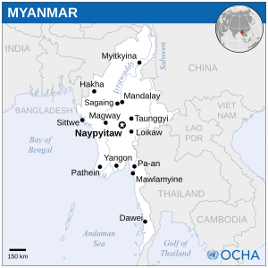
Myanmar, officially the Republic of the Union of Myanmar, also known as Burma, is a country in Southeast Asia. It is the largest country by area in Mainland Southeast Asia and has a population of about 55 million. It is bordered by Bangladesh and India to its northwest, China to its northeast, Laos and Thailand to its east and southeast, and the Andaman Sea and the Bay of Bengal to its south and southwest. The country's capital city is Naypyidaw, and its largest city is Yangon.

<span class="mw-page-title-main">Yangon</span> Largest city of Myanmar (Burma)

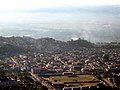
Yangon, formerly romanized as Rangoon, is the capital of the Yangon Region and the largest city of Myanmar. Yangon served as the capital of Myanmar until 2006, when the military government relocated the administrative functions to the purpose-built capital city of Naypyidaw in north central Myanmar. With over five million people, Yangon is Myanmar's most populous city and its most important commercial centre.

<span class="mw-page-title-main">United Nations Population Fund</span> United Nations organization

The United Nations Population Fund (UNFPA), formerly the United Nations Fund for Population Activities, is a UN agency aimed at improving reproductive and maternal health worldwide. Its work includes developing national healthcare strategies and protocols, increasing access to birth control, and leading campaigns against child marriage, gender-based violence, obstetric fistula, and female genital mutilation.

<span class="mw-page-title-main">Mandalay</span> Second-largest city in Myanmar

Mandalay is the second-largest city in Myanmar, after Yangon. Located on the east bank of the Irrawaddy River, 631 km north of Yangon, the city has a population of 1,225,553.

<span class="mw-page-title-main">Magway Region</span> Region of Myanmar

Magway Region is an administrative division in central Myanmar. It is the second largest of Myanmar's seven divisions, with an area of 44,820 km2. Pa Del Dam (ပဒဲဆည်) is one of the dams in Aunglan Township, Magway Division. The capital and second largest city of the Magway Division is Magway. The largest city is Pakokku. The major cities of Magway Division are Magway, Pakokku, Aunglan, Yenangyaung, Taungdwingyi, Chauk, Minbu, Thayet and Gangaw.

<span class="mw-page-title-main">Sagaing Region</span> Region of Myanmar

Sagaing Region is an administrative region of Myanmar, located in the north-western part of the country between latitude 21° 30' north and longitude 94° 97' east. It is bordered by India's Nagaland, Manipur, and Arunachal Pradesh States to the north, Kachin State, Shan State, and Mandalay Region to the east, Mandalay Region and Magway Region to the south, with the Ayeyarwady River forming a greater part of its eastern and also southern boundary, and Chin State and India to the west. The region has an area of 93,527 square kilometres (36,111 sq mi). In 1996, it had a population of over 5,300,000 while its population in 2012 was 6,600,000. The urban population in 2012 was 1,230,000 and the rural population was 5,360,000. The Capital city and the largest city of Sagaing Region is Monywa.

<span class="mw-page-title-main">Rakhine State</span> State of Myanmar

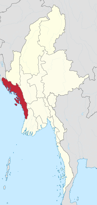
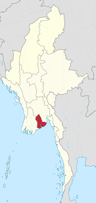
Rakhine State, formerly known as Arakan State, is a state in Myanmar (Burma). Situated on the western coast, it is bordered by Chin State to the north, Magway Region, Bago Region and Ayeyarwady Region to the east, the Bay of Bengal to the west and the Chittagong Division of Bangladesh to the northwest. It is located approximately between latitudes 17°30' north and 21°30' north and longitudes 92°10' east and 94°50' east. The Arakan Mountains or Rakhine Yoma separated Rakhine State from central Burma from North to South. Off the coast of Rakhine State there are some fairly large islands such as Ramree, Cheduba and Myingun. Rakhine State has an area of 36,762 square kilometres (14,194 sq mi) and its capital is Sittwe.

<span class="mw-page-title-main">Administrative divisions of Myanmar</span> First-level political subdivisions of Myanmar

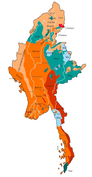
Myanmar is divided into 21 administrative divisions, which include seven regions, seven states, one union territory, one self-administered division, and five self-administered zones.

<span class="mw-page-title-main">Hinduism in Myanmar</span> Overview of the presence, role and impact of Hinduism in Myanmar

Hinduism is the Fourth-largest religion in Myanmar, being practised by 1.7% of the population of Myanmar. Hinduism is practised by about 890,000 people in Myanmar, and has been influenced by elements of Buddhism, with many Hindu temples in Myanmar housing statues of the Buddha. There are also a large population of Hindus in which the Myanmar Tamils and minority Bengali Hindus having the biggest population share.

<span class="mw-page-title-main">Yangon Region</span> Region of Myanmar

Yangon Region(Burmese: ရန်ကုန်တိုင်းဒေသကြီး; MLCTS: rankun tuing desa. kri:, pronounced[jàɰ̃ɡòʊɰ̃táɪɰ̃dèθa̰dʑí]; formerly Rangoon Division and Yangon Division) is an administrative region of Myanmar. Located in central Myanmar, the division is bordered by Bago Region to the north and east, the Gulf of Martaban to the south, and Ayeyarwady Region to the west. Yangon Region is dominated by its capital city of Yangon, the former national capital and the largest city in the country. Other important cities are Thanlyin and Twante. The division is the most developed region of the country and the main international gateway. The division measures 10,170 km2 (3,930 sq mi).

<span class="mw-page-title-main">Western Area</span> Subdivision of Sierra Leone

The Western Area or Freetown Peninsula is one of five principal divisions of Sierra Leone. It comprises the oldest city and national capital Freetown and its surrounding towns and countryside. It covers an area of 557 km2 and has a population of 1,447,271. The Western Area is located mostly around the peninsula and is divided into two districts: the Western Area Rural and the Western Area Urban.

<span class="mw-page-title-main">Taunggyi</span> City in Shan State,Taunggyi, Myanmar

Taunggyi is the capital and largest city of Shan State, Myanmar (Burma) and lies on the Thazi-Kyaingtong road at an elevation of 4,712 feet (1,436 m), just north of Shwenyaung and Inle Lake within the Myelat region. Taunggyi is the fifth largest city of Myanmar, and has an estimated population of 380,665 as of 2014. The city is famous for its hot air balloon festival held annually on the full moon day of Tazaungmon.

<span class="mw-page-title-main">Burmese Americans</span> Americans of Burmese birth or descent

Burmese Americans are Americans of full or partial Burmese ancestry, encompassing individuals of all ethnic backgrounds with ancestry in present-day Myanmar, regardless of specific ethnicity. As a subgroup of Asian Americans, Burmese Americans have largely integrated into the broader Southeast Asian and South Asian American communities.

<span class="mw-page-title-main">Kengtung</span> Town in Shan State, Myanmar

Kengtung, also spelt Kyaingtong, is a town in Shan State, Myanmar. It is the principal town of Kengtung Township and the former seat of Kengtung State, a minor principality. Kengtung is located on the National Highway 4 (NH4) and at the AH2 and AH3 of the Asian Highway.

<span class="mw-page-title-main">Landhi</span> Residential neighbourhood in Karchi, Pakistan

Landhi is a residential neighbourhood and an industrial municipality in the eastern part of Karachi, Pakistan. It is bordered by the Faisal Cantonment and Shah Faisal Colony to the north across the Malir River, Bin Qasim Port to the south and east, and Korangi to the west.

<span class="mw-page-title-main">Pathein District</span> District of Ayeyarwady Division in Myanmar

Pathein District is a district of Ayeyawady Division, Myanmar. It is located around and includes the urban area of the city of Pathein. The area of the Pathein District is 10,899.8 km2 (4,208.4 sq mi). Its population was 1,630,716 in 2014.

The Lai people mainly inhabit the southern parts of Chin Hills in Myanmar's Chin State, in the townships of Falam, Thantlang and Hakha. They are also found in the Lawngtlai district of Mizoram, India, where they have been granted the Lai Autonomous District Council. Outside this area they are scattered in Mizoram and in Manipur. Their languages "Laizo Lai" and "Hakha Lai" are classified as Central Kuki-Chin languages.

Hlaing Township, also spelt Hline, is an area of Yangon, Myanmar in the West Yangon District of Yangon Region. The township is entirely urban and comprises 16 wards. In 2000, the township's population was estimated to be about 125,000.

7 Billion Actions is a worldwide campaign established by the United Nations Population Fund (UNFPA) in 2011 to commemorate the world population milestone of 7 billion people. UNFPA is a United Nations organization that works on population and development issues, with an emphasis on reproductive health and gender equality. 7 Billion Actions works with multiple corporations, organizations and individuals to address the 7 Key Issues such as poverty, gender equality, youth, ageing, urbanization, environment, and reproductive health and rights. The UN has declared the World Population surpassing 7 billion on 31 October 2011. Prior to this date, the UN celebrated the Day of Six Billion in October 1999.

<span class="mw-page-title-main">2014 Myanmar census</span> National census of Myanmar undertaken in 2014

The Myanmar census 2014 was a nationwide census between 30 March and 10 April 2014 in Myanmar (Burma). 100,000 school teachers counted the population at midnight 29 March. The theme of the census campaign was A nationwide census – Let us all Participate.

References

  1. "UNFPA Myanmar - Census". Myanmar.unfpa.org. Retrieved 5 February 2019.