List of council estates in the United Kingdom

Last updated

This is a list of notable council estates. Public housing in the United Kingdom has typically consisted of council houses, often built in the form of large estates by local government councils.

Contents

Becontree in The London Borough of Barking & Dagenham is generally considered to be the largest council estate (in terms of population).

Some council estates, such as Heygate Estate (setting of the movie Harry Brown ) in London, or Hulme Crescents in Manchester, have since been demolished.

England

London

Largest

EstateImageDatesLocationSize (units)Notes/Description
1 Churchill Gardens Churchill Gardens Estate, Churchill Gardens Road (geograph 2678683).jpg 1946-62 built Pimlico area of Westminster, London
51°29′13″N0°08′24″W / 51.487°N 0.140°W / 51.487; -0.140 (Churchill Gardens)
1,600Designed by architects Powell and Moya to replace Victorian terraced houses extensively damaged during the Blitz; won RIBA London Architectural Bronze Medal (1950); model for many later projects.
2 Grahame Park Graham Park.JPG 1971 first move-in Colindale area of Barnet, London
51°36′07″N0°14′53″W / 51.602°N 0.248°W / 51.602; -0.248 (Grahame Park)
1,177Built on site of the old Hendon Aerodrome in North West London. Named for Claude Grahame-White, aviation pioneer who established the aerodrome. Plain, square, brick terraced houses and "Brick Brutalist" low-rise flats. Brick Brutalist Colindale, currently being demolished/refurbished
3 Becontree Homes Fit for Heroes Dagenham - geograph.org.uk - 50407.jpg 1921-35 built Barking and Dagenham, London
51°32′55″N0°08′34″E / 51.5487°N 0.1427°E / 51.5487; 0.1427 (Becontree)
26,000Built by London County Council outside of the then-limits of County of London. Population over 100,000; asserted to be the largest public housing development in the world.
Chalkhill Estate 1966-70 built Wembley Park area of Brent, London
51°33′50″N0°16′12″W / 51.564°N 0.270°W / 51.564; -0.270 (Chalkhill Estate)
1,900Early example of compulsory purchase; many homes of 1921 era Metroland-type development had to be demolished. Charges of engineering area to swing MP seat from Conservative to Labour were levied, though in fact Conservative served from 1974 to 1997. Low—rises and 30 high-rise "Bison" built blocks. Design based on that of Park Hill in Sheffield.
Stonebridge Estate Stonebridge Estate 2007.jpg 1960s-1970s built Brent, London
51°32′30″N0°15′40″W / 51.541637°N 0.261200°W / 51.541637; -0.261200 (Stonebridge Estate)
1,775Highest recorded gun crime of any ward in London.
South Kilburn South Kilburn Estate - geograph.org.uk - 417246.jpg 1959-1970s built; redevelopments 2014- Brent, London
51°31′48″N0°11′49″W / 51.530°N 0.197°W / 51.530; -0.197 (South Kilburn)
Low-rise flats and 11 concrete tower blocks in Brutalist style. Severe crime problems.
St Raphael's Estate built Brent, London
51°33′02″N0°15′54″W / 51.550536°N 0.264883°W / 51.550536; -0.264883 (St. Raphael's Estate)
1,174Low density.


Other

West Midlands

EstateImageDatesLocationSize (units)Notes/Description
2 Austin Village Austin Village 8.jpg 1917 built Northfield, Birmingham-adjacent
52°24′04″N1°58′23″W / 52.401°N 1.973°W / 52.401; -1.973 (Austin Village)
200 Cedar prefabricated bungalows erected during the First World War to support Austin Motor Company's manufacture of tanks and aircraft.
Brierley Hill flats in Dudley Brierley hill flats 2.jpg
Brierley Hill flats in Dudley

Birmingham

Dudley

Sandwell

Solihull

Walsall

Wolverhampton

Telford

Greater Manchester

Flats on Birchtree Court, Wythenshawe, Manchester Edwards ^ Birchtree Court, Wythenshawe - panoramio.jpg
Flats on Birchtree Court, Wythenshawe, Manchester

City of Manchester

Tameside

West Yorkshire

Queensview Tower in Seacroft, Leeds Seacroft Green shopping centre and Queensview (11th June 2010).jpg
Queensview Tower in Seacroft, Leeds
Lovell Park Flats, Leeds Lovell Park (left to right) Towers, Grange, Heights, Little London, Leeds (29th March 2018).jpg
Lovell Park Flats, Leeds

Leeds

Bradford

Reyhill Grove, Bradford Reyhill Grove - Manchester Road - geograph.org.uk - 1021762.jpg
Reyhill Grove, Bradford

South Yorkshire

Renovated Park Hill flats in Sheffield Sheffield - renovated Park Hill flats.jpg
Renovated Park Hill flats in Sheffield

Sheffield

North Yorkshire

Middlesbrough

Block of Council Flats in Middlesbrough The Roman Catholic cemetery in Thorntree - geograph.org.uk - 1691557.jpg
Block of Council Flats in Middlesbrough

East Riding of Yorkshire

High Rise Flats on Anlaby Road, Hull Great Thornton Street flats, Hull - geograph.org.uk - 1249532.jpg
High Rise Flats on Anlaby Road, Hull

Kingston upon Hull

Merseyside

Knowsley

Liverpool

Norfolk

Norwich

Hampshire

Portsmouth

Havant

Southampton

Oxfordshire

Oxford

Surrey

Mole Valley

Tyne and Wear

Tom Collins House, Byker Wall Estate, Newcastle Upon Tyne Tomcollinshouse 1.jpg
Tom Collins House, Byker Wall Estate, Newcastle Upon Tyne

Newcastle upon Tyne

Sunderland


Bristol Pre-war estates

Knowle West Estate Southmead Estate Hillfields Estate Horfield Estate Bedminster Down Estate

Parts of Bishopsworth and Withywood area also house many pre-war cottage style council housing.

Post-war estates

Hartcliffe, Withywood Estate Lockleaze Estate Lawrence Weston Estate Lawrence Hill and Barton Hill Estates Patchway Estate Redcliffe Estate St Jude's Estate

Parts of Horfield, Bedminster, Avonmouth areas also house post-war council housing.

Scotland

Glasgow

High rise flats in Wyndford Road, Glasgow Flats at Wyndford Road, Glasgow (geograph 4205923).jpg
High rise flats in Wyndford Road, Glasgow
Tower Blocks in Hutchesontown in Glasgow Housing in Hutchesontown (geograph 3894101).jpg
Tower Blocks in Hutchesontown in Glasgow
Anniesland Court in Anniesland, North West Glasgow Tower Block at Anniesland Cross - geograph.org.uk - 382234.jpg
Anniesland Court in Anniesland, North West Glasgow

Edinburgh

Tower Block in Muirhouse, Edinburgh Tower Block in Muirhouse (geograph 2872883).jpg
Tower Block in Muirhouse, Edinburgh

Dundee

Other

Northern Ireland

Greater Belfast

Derry

Related Research Articles

<span class="mw-page-title-main">West Midlands (county)</span> County of England

West Midlands is a metropolitan and ceremonial county in the larger West Midlands region of England. A landlocked county, it is bordered by Staffordshire to the north and west, Worcestershire to the south, and is surrounded by Warwickshire to the east. The largest settlement is the city of Birmingham.

<span class="mw-page-title-main">Walsall</span> Market town in West Midlands County, England

Walsall is a market town and administrative centre in the West Midlands County, England. Historically part of Staffordshire, it is located 9 miles (14 km) north-west of Birmingham, 7 miles (11 km) east of Wolverhampton and 9 miles (14 km) from Lichfield.

<span class="mw-page-title-main">West Bromwich</span> Town in West Midlands, England

West Bromwich is a market town in the borough of Sandwell, West Midlands, England. Historically part of Staffordshire, it is 7 miles northwest of Birmingham. West Bromwich is part of the area known as the Black Country, in terms of geography, culture and dialect. West Bromwich had a population of 103,112 in the 2021 Census.

<span class="mw-page-title-main">Tipton</span> Town in the West Midlands, England

Tipton is an industrial town in the Metropolitan Borough of Sandwell in the West Midlands County in England. It had a population of 38,777 at the 2011 UK Census. It is located northwest of Birmingham and southeast of Wolverhampton. It is also contiguous with nearby towns of Darlaston, Dudley, Wednesbury and Bilston.

<span class="mw-page-title-main">Smethwick</span> Town in West Midlands, England

Smethwick is an industrial town in Sandwell, West Midlands, England. It lies 4 miles (6 km) west of Birmingham city centre. Historically it was in Staffordshire and then Worcestershire before being placed into then West Midlands county.

<span class="mw-page-title-main">Wednesbury</span> Town in West Midlands, England

Wednesbury is a market town in Sandwell in the West Midlands County, England. It is located near the source of the River Tame, and is part of the Black Country. Wednesbury is situated 5 miles (8km) south-east of Wolverhampton, 2.7 miles (4.4km) south-west of Walsall, and 7.3 miles (11.8km) north-west of Birmingham. At the 2011 Census the town had a population of 37,817.

<span class="mw-page-title-main">Bilston</span> Market town in the West Midlands, England

Bilston is a town in Wolverhampton, in the West Midlands, England. It is close to the borders of Sandwell and Walsall. The nearest towns are Darlaston, Wednesbury, and Willenhall. Historically in Staffordshire, three wards of Wolverhampton City Council now cover the town: Bilston East and Bilston North, which almost entirely comprise parts of the historic Borough of Bilston, and Ettingshall, which comprises a part of Bilston and parts of Wolverhampton.

<span class="mw-page-title-main">Darlaston</span> Town in West Midlands, England

Darlaston is an industrial town in the Metropolitan Borough of Walsall in the West Midlands of England. It is located near Wednesbury and Willenhall.

The West Midlands region straddles the historic borders between the counties of Warwickshire, Staffordshire in the north, and Worcestershire in the south.

<span class="mw-page-title-main">Tividale</span> Human settlement in England

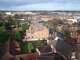
Tividale is a district of the Metropolitan Borough of Sandwell, West Midlands.

<span class="mw-page-title-main">Coseley</span> Human settlement in England

Coseley is a village in the Dudley Metropolitan Borough, in the West Midlands County, England. It is situated three miles north of Dudley itself, on the border with Wolverhampton. Though it is a part of the Dudley North constituency. It also falls within the Wolverhampton South-East parliamentary constituency.

<span class="mw-page-title-main">Parliamentary constituencies in London</span>

The region of Greater London, including the City of London, is divided into 73 parliamentary constituencies which are sub-classified as borough constituencies, affecting the type of electoral officer and level of expenses permitted.

The Priory Estate is a housing estate in Dudley, West Midlands, England, which has largely been developed since 1929.

<span class="mw-page-title-main">A4123 road</span>

The A4123, is a major road in the West Midlands of the UK linking Wolverhampton with Birmingham via Dudley, also known as the Birmingham New Road and Wolverhampton Road. It was one of the first major new roads constructed for use by motor traffic, and was designed as an unemployment relief project. It runs roughly northwest to southeast from the Wolverhampton Ring Road via Dudley to Harborne, west Birmingham. Until the 1960s, the road continued along the former B4123 to the A441 near Kings Norton. This became part of the A4040 during the 1960s when the Outer Ring Road came into existence.

<span class="mw-page-title-main">Coseley Urban District</span> Local government district in Staffordshire, England

Coseley Urban District was a local government district in Staffordshire which was created in 1894.

<span class="mw-page-title-main">Eve Hill</span>

Eve Hill is a residential area of Dudley in the West Midlands of England. It was part of Worcestershire until 1966 and briefly part of Staffordshire until 1974.

The South Staffordshire and Birmingham District Steam Tramways Company which became the South Staffordshire Tramways Company operated a tramway service from their depot in Wednesbury between 1883 and 1924.

South Bristol is the part of Bristol, England south of the Bristol Avon. It is almost entirely made up of the areas of the city historically in Somerset, and since the abolition of the county Avon, consists of the southern suburbs in the county of Bristol. Definitions sometimes also include areas of North Somerset, including Long Ashton, Nailsea and Backwell.

References

  1. The Byker Redevelopment, BBC, 6/1/2007.