Islamabad Capital Territory is located on the Pothohar Plateau where excavations have revealed evidence of a prehistoric culture. [1] [2] Relics and human skulls have been found dating back to 5000 BC that show this region was home to Neolithic people who settled on the banks of the Soan River, and developed small communities in the region at around 3000 BC. [2] Islamabad's cultural heritage includes various archaeological sites, government buildings, shrines, stupas, landmarks, and national monuments. According to one survey by Quaid-i-Azam University in 2010, there are around 450 heritage sites in the capital territory and the adjoining Rawalpindi district. [3] The Capital Development Authority formed a committee in 2011 to locate and preserve 150 of these historical and archaeological sites. [4]
Following is an incomplete list of the cultural heritage sites in Islamabad Capital Territory.
| ID | Name | Type | Location | District | Coordinates | Image |
|---|---|---|---|---|---|---|
| ICT-1 | Mausoleum of Meher Ali Shah | Shrine | In Golra Sharif, Sector E-11 | Islamabad | 33°41′29″N72°58′27″E / 33.6915°N 72.9742°E |  |
| ICT-2 | Golra Sharif Railway Museum and Station | Museum and historical site | Located on Golra Road | Islamabad Capital Territory | 33°40′15″N72°56′51″E / 33.6708°N 72.9476°E |  |
| ICT-3 | Saidpur Village | Historical site | On Khayaban-e-Iqbal, opposite Sector F-6, parallel to Islamabad Zoo | Islamabad Capital Territory | 33°44′34″N73°04′04″E / 33.7427°N 73.0678°E | 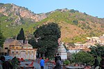 |
| ICT-4 | Pakistan Monument | Landmark | Located on Shakarparian near Zero Point Interchange | Islamabad | 33°41′36″N73°04′06″E / 33.6933°N 73.0682°E |  |
| ICT-5 | Faisal Mosque | Mosque | Located at end of Shahrah-e-Faisal at the foot of Margalla Hills | Islamabad Capital Territory | 33°43′47″N73°02′15″E / 33.7297°N 73.0376°E |  |
| ICT-6 | Bari Imam | Shrine | Nurpur Shahan village - 4 kilometres (2.5 mi) northeast of the Diplomatic Enclave [5] | Islamabad Capital Territory | 33°44′43″N73°06′40″E / 33.7453°N 73.1112°E | 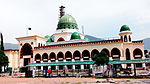 |
| ICT-7 | Pakistan Museum of Natural History | Museum | Garden Avenue, Shakarparian [6] | Islamabad | 33°41′10″N73°04′35″E / 33.6862°N 73.0765°E |  |
| ICT-8 | Parliament House | Official building | on Constitution Avenue [7] | Islamabad city | 33°43′55″N73°05′45″E / 33.7319°N 73.0957°E |  |
| ICT-9 | Supreme Court of Pakistan | Official building | on Constitution Avenue | Islamabad city | 33°43′39″N73°05′54″E / 33.7275°N 73.0984°E |  |
| ICT-10 | Aiwan-e-Sadr | Official building | on Constitution Avenue | Islamabad | 33°43′53″N73°05′51″E / 33.7315°N 73.0974°E |  |
| ICT-11 | Prime Minister's Secretariat | Official building | on Constitution Avenue | Islamabad | 33°43′33″N73°06′00″E / 33.7257°N 73.0999°E |  |
| ICT-12 | Pak Secretariat buildings | Official building | on Constitution Avenue | Islamabad | 33°44′07″N73°05′34″E / 33.7353°N 73.0929°E |  |
| ICT-13 | National Archives of Pakistan | Official building | on Constitution Avenue | Islamabad | 33°44′24″N73°05′41″E / 33.7399°N 73.0947°E |  Upload Photo |
| ICT-14 | National Library of Pakistan | Official building | Behind Prime Minister's Secretariat | Islamabad | 33°43′34″N73°06′07″E / 33.7262°N 73.1019°E |  |
| ICT-15 | Jinnah Convention Centre | Building | On Murree Road near Kashmir Chowk | Islamabad | 33°42′45″N73°06′17″E / 33.7126°N 73.1047°E |  |
| ICT-16 | Punjab House | Official building | Sector F-5 | Islamabad | 33°44′34″N73°05′25″E / 33.7427°N 73.0902°E |  |
| ICT-17 | Sindh House | Official building | Sector F-5 | Islamabad | 33°44′20″N73°05′16″E / 33.7390°N 73.0879°E | 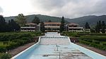 |
| ICT-18 | Kashmir House | Official building | Sector F-5 | Islamabad | 33°44′13″N73°05′01″E / 33.7370°N 73.0837°E | Upload Photo |
| ICT-19 | Balochistan House | Official building | Sector F-5 | Islamabad | 33°44′06″N73°05′23″E / 33.7351°N 73.0896°E |  |
| ICT-20 | Khyber Pakhtunkhwa House | Official building | Sector F-5 | Islamabad | 33°44′05″N73°05′13″E / 33.7346°N 73.0869°E | Upload Photo |
| ICT-21 | Buddhist and Hindu sites at Shah Allah Ditta village | Archaeological site | various sites in Shah Allah Ditta village | Islamabad Capital Territory |  | |
| ICT-22 | Shah Allah Ditta caves | Archaeological site | Near the shrine of Shah Allah Ditta [8] | Islamabad Capital Territory | 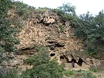 | |
| ICT-23 | Sadhu ka Bagh | Archaeological site | In Shah Allah Ditta village near the caves [8] | Islamabad Capital Territory |  | |
| ICT-24 | Jira rock shelters | Archaeological site | near the village of Bobri [9] | Islamabad Capital Territory |  | |
| ICT-25 | Bobri rock shelters | Archaeological site | South of the village of Bobri [9] | Islamabad Capital Territory | Upload Photo | |
| ICT-26 | Phulgran rock shelter and natural menhirs | Archaeological site | In Phulgran village [9] | Islamabad Capital Territory | Upload Photo | |
| ICT-27 | Darwala rock shelters and natural menhirs | Archaeological site | In Darwala village [9] | Islamabad Capital Territory | Upload Photo | |
| ICT-28 | Bora Bangial rock shelters and natural menhirs | Archaeological site | In Bora Bangial village [9] | Islamabad Capital Territory | Upload Photo | |
| ICT-29 | Peja rock shelters and natural menhirs | Archaeological site | In Peja village [9] | Islamabad Capital Territory | Upload Photo | |
| ICT-30 | Gora Mast rock shelters and natural menhirs | Archaeological site | In Gora Mast village [9] | Islamabad Capital Territory | Upload Photo | |
| ICT-31 | Bhimbar Tarar rock shelters and natural menhirs | Archaeological site | In Bhimbar Tarar village [9] | Islamabad Capital Territory | Upload Photo | |
| ICT-32 | Bagh Jogian caves | Archaeological site | In Bagh Jogian village [9] | Islamabad Capital Territory | Upload Photo | |
| ICT-33 | Meharabad Buddhist mound and stupas | Archaeological site | Meharabad, Sector G-12 | Islamabad Capital Territory | Upload Photo | |
| ICT-34 | Chauntra caves | Archaeological site | North of Sector E-11 | Islamabad Capital Territory |  | |
| ICT-35 | Ban Faqiraan stupas | Archaeological site | Ban Faqiraan [9] | Islamabad Capital Territory | Upload Photo | |
| ICT-36 | Ban Faqiraan mosque | Mosque | Ban Faqiraan [9] | Islamabad Capital Territory | Upload Photo | |
| ICT-37 | Lizard Rock (rock shelter) | Archaeological site | Lizard Rock Park, Sector G-13 [4] | Islamabad Capital Territory |  | |
| ICT-38 | Islamabad di daat | Landmark | Fatima Jinnah Park, Sector F-9 | Islamabad | 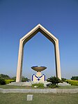 | |
| ICT-39 | Fatima Jinnah Park baradri | Landmark | Near the Bolan Gate of Fatima Jinnah Park, Sector F-9 | Islamabad | 33°41′49″N73°01′03″E / 33.6969°N 73.0175°E | 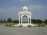 |
| ICT-40 | Three domes | Landmark | Fatima Jinnah Park, Sector F-9 | Islamabad | 33°42′16″N73°01′04″E / 33.7044°N 73.0178°E |  |
| ICT-41 | Reflecting ponds (poetry walls) | Landmark | Fatima Jinnah Park, Sector F-9 | Islamabad | 33°42′21″N73°01′02″E / 33.7057°N 73.0173°E |  |
| ICT-42 | Chaghi Monument | Landmark | Faizabad Interchange | Islamabad | 33°40′00″N73°05′10″E / 33.6668°N 73.0861°E |  |
| ICT-43 | Chan Pir Badsah Darbar | Shrine | In Pandorian, Shehzad Town | Islamabad Capital Territory | 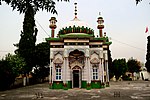 | |
| ICT-44 | Lok Virsa Museum | Museum | Garden Avenue, Shakarparian | Islamabad | 33°41′20″N73°04′21″E / 33.6889°N 73.0725°E |  |
| ICT-45 | Saudi-Pak Tower | Building | Blue Area | Islamabad | 33°42′51″N73°03′47″E / 33.7142°N 73.063°E |  |
| ICT-46 | Crescent and Star monument | Landmark | on Garden Avenue near Rose and Jasmine Garden | Islamabad | 33°41′53″N73°05′10″E / 33.698027°N 73.086183°E | 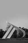 |
| ICT-47 | Sain cup marks | Archaeological site | Sain village [10] | Islamabad Capital Territory | Upload Photo | |
| ICT-48 | Gumbat cup marks | Archaeological site | Gumbat village [10] | Islamabad Capital Territory | Upload Photo | |
| ICT-49 | G-10 rock shelter, petroglyphs, and cup marks | Archaeological site | Next to Usman Mosque near Buland Market, G-10/1 [10] | Islamabad | 33°40′24″N73°00′47″E / 33.673215°N 73.013163°E |  |
| ICT-50 | Arazi Sahal cup marks | Archaeological site | Arazi Sahal village [10] | Islamabad Capital Territory | Upload Photo | |
| ICT-51 | G-13 petroglyphs | Archaeological site | Sector G-13/4 [10] | Islamabad Capital Territory | Upload Photo |