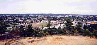
The following list includes all of the Canadian Register of Historic Places listings in North Shore, British Columbia, including:
- North Shore Mountains,
- North Vancouver City,
- North Vancouver District Municipality, and
- West Vancouver District Municipality.
| Name | Address | Coordinates | IDF | IDP | IDM | | Image |
|---|---|---|---|---|---|---|---|
| 214 West 6th Street | 214 West 6th Street, North Vancouver, BC | 49°19′04″N123°04′41″W / 49.3178°N 123.078°W | 2435 |  More images | |||
| 240 East 10th Street Residence | 240 East 10th Street, North Vancouver, BC | 49°19′02″N123°04′01″W / 49.3171°N 123.067°W | 6208 |  More images | |||
| 254 Keith Road East Residence | 254 Keith Road East, North Vancouver, BC | 49°18′54″N123°04′05″W / 49.3149°N 123.068°W | 6197 |  More images | |||
| 256 East 10th Street Residence | 256 East 10th Street, North Vancouver, BC | 49°19′02″N123°04′01″W / 49.3171°N 123.067°W | 6325 |  | |||
| 268 West 6th Street | 268 West 6th Street, North Vancouver City, BC | 49°19′07″N123°04′48″W / 49.3187°N 123.08°W | 3819 |  More images | |||
| 832 Cumberland Crescent | 832 Cumberland Crescent, North Vancouver City, BC | 49°19′34″N123°05′46″W / 49.326°N 123.096°W | 3812 | | |||
| 842 Cumberland Crescent | 842 Cumberland Cresecent, North Vancouver City, BC | 49°19′34″N123°05′46″W / 49.3261°N 123.096°W | 3811 | | |||
| 852 Cumberland Crescent | 852 Cumberland Crescent, North Vancouver City, BC | 49°19′34″N123°05′46″W / 49.3261°N 123.096°W | 3810 | | |||
| 862 Cumberland Crescent | 862 Cumberland Crescent, North Vancouver City, BC | 49°19′34″N123°05′49″W / 49.3261°N 123.097°W | 3809 | | |||
| 872 Cumberland Crescent | 872 Cumberland Crescent, North Vancouver City, BC | 49°19′34″N123°05′49″W / 49.3261°N 123.097°W | 3808 | | |||
| Aberdeen Block | 90 Lonsdale Avenue, North Vancouver, BC | 49°18′43″N123°04′41″W / 49.3119°N 123.078°W | 2403 | 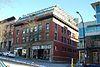 More images | |||
| Administration Building | 131 East 2nd Street, North Vancouver, BC | 49°18′44″N123°04′37″W / 49.3122°N 123.077°W | 2402 |  More images | |||
| Archibald Residence | 227 East 10th Street, North Vancouver, BC | 49°19′00″N123°04′05″W / 49.3166°N 123.068°W | 2480 |  More images | |||
| Armoury | West 15th Street at Forbes Avenue, North Vancouver, BC | 49°19′20″N123°05′06″W / 49.3222°N 123.0851°W | 3608 | | |||
| B.C. Telephone Building | 117 West 1st Street, North Vancouver, BC | 49°18′43″N123°04′44″W / 49.312°N 123.079°W | 2410 | 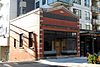 More images | |||
| Baker Residence | 650 Keith Road West, North Vancouver, BC | 49°19′13″N123°05′24″W / 49.3204°N 123.09°W | 2442 | | |||
| Bank of Hamilton Chambers | 92 Lonsdale Avenue, North Vancouver, BC | 49°18′42″N123°04′41″W / 49.3117°N 123.078°W | 2408 |  More images | |||
| Beasley Block | 101 Lonsdale Avenue, North Vancouver, BC | 49°18′43″N123°04′44″W / 49.312°N 123.079°W | 2407 |  More images | |||
| Binning Residence National Historic Site of Canada | 2968 Mathers Crescent, West Vancouver, BC | 49°20′25″N123°11′49″W / 49.3403°N 123.197°W | 11968 | | |||
| Bow Residence | 320 Tempe Crescent, North Vancouver, BC | 49°20′07″N123°03′54″W / 49.3354°N 123.065°W | 2400 | | |||
| Brown Residence | 238 East 11th Street, North Vancouver, BC | 49°19′04″N123°04′05″W / 49.3179°N 123.068°W | 2485 | | |||
| Burrard Dry Dock Company | 109 East Esplanade, North Vancouver, BC | 49°18′30″N123°04′44″W / 49.3084°N 123.079°W | 2443 | 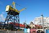 More images | |||
| Captain Archibald Residence | 2735 Lonsdale Avenue, North Vancouver, BC | 49°20′05″N123°04′19″W / 49.3348°N 123.072°W | 2399 | | |||
| Central School | 333 Chesterfield Avenue, North Vancouver, BC | 49°18′55″N123°04′47″W / 49.3153°N 123.0797°W | 2436 | | |||
| Chubb Residence | 345 East 9th Street, North Vancouver City, BC | 49°18′55″N123°03′50″W / 49.3154°N 123.064°W | 3830 |  More images | |||
| Church of St. John the Evangelist | 333 Chesterfield Avenue, North Vancouver, BC | 49°18′55″N123°04′52″W / 49.3153°N 123.081°W | 2440 |  More images | |||
| Clapham Residence | 736 East 3rd Street, North Vancouver, BC | 49°18′32″N123°03′32″W / 49.3088°N 123.059°W | 6328 |  More images | |||
| Colonial Apartments | 160 East 10th Street, North Vancouver, BC | 49°19′01″N123°04′12″W / 49.317°N 123.07°W | 2439 |  More images | |||
| Commercial Block | 277 East 8th Street, North Vancouver, BC | 49°18′54″N123°04′01″W / 49.3151°N 123.067°W | 2467 | 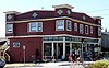 More images | |||
| Coronation Block | 105 Esplanade Avenue West, North Vancouver, BC | 49°18′40″N123°04′48″W / 49.3111°N 123.08°W | 2438 |  More images | |||
| Crease Residence | 246 East 10th Street, North Vancouver, BC | 49°19′02″N123°04′01″W / 49.3171°N 123.067°W | 6324 | | |||
| Cunliffe Residence | 419 East 13th Street, North Vancouver, BC | 49°19′11″N123°03′43″W / 49.3196°N 123.062°W | 6205 |  More images | |||
| Cunningham Residence | 172 East 25th Street, North Vancouver City, BC | 49°19′57″N123°04′08″W / 49.3325°N 123.069°W | 3806 | | |||
| Deptford Residence | 426 Keith Road West, North Vancouver, BC | 49°19′13″N123°04′59″W / 49.3204°N 123.083°W | 6203 |  More images | |||
| Doherty Residence | 309 East 12th Street, North Vancouver, BC | 49°19′07″N123°03′58″W / 49.3186°N 123.066°W | 6327 |  More images | |||
| Doney Residence | 745 Grand Boulevard, North Vancouver, BC | 49°18′49″N123°03′29″W / 49.3136°N 123.058°W | 2423 |  More images | |||
| Drysdale Residence | 266 West 6th Street, North Vancouver City, BC | 49°19′07″N123°04′48″W / 49.3187°N 123.08°W | 3818 |  More images | |||
| Edington Residence | 848 East 6th Street, North Vancouver, BC | 49°18′42″N123°03′07″W / 49.3117°N 123.052°W | 6331 | | |||
| Ellis Residence | 800 Grand Boulevard, North Vancouver, BC | 49°18′53″N123°03′22″W / 49.3148°N 123.056°W | 2424 |  More images | |||
| Emery Residence | 256 East 1st Street, North Vancouver, BC | 49°18′36″N123°04′23″W / 49.3099°N 123.073°W | 6206 | | |||
| Falcioni Residence | 168 East 1st Street, North Vancouver City, BC | 49°18′40″N123°04′34″W / 49.3111°N 123.076°W | 3833 |  More images | |||
| Fawcett Residence | 442 East 2nd Street, North Vancouver, BC | 49°18′30″N123°04′01″W / 49.3083°N 123.067°W | 6333 | | |||
| Finlay's Row | 200 Block East 19th Street, North Vancouver, BC | 49°19′33″N123°04′05″W / 49.3259°N 123.068°W | 2465 |  More images | |||
| First Church of Christ Scientist | 185 Keith Road, North Vancouver, BC | 49°18′55″N123°04′16″W / 49.3153°N 123.071°W | 2412 |  More images | |||
| Foster Residence | 276 Keith Road East, North Vancouver, BC | 49°18′53″N123°04′01″W / 49.3147°N 123.067°W | 6198 |  More images | |||
| Gill Residence | 1617 Grand Boulevard, North Vancouver, BC | 49°19′24″N123°03′29″W / 49.3232°N 123.058°W | 2415 |  More images | |||
| Gill Residence | 231 East 10th Street, North Vancouver, BC | 49°19′00″N123°04′05″W / 49.3168°N 123.0680°W | 2415 | | |||
| Gill Residence | 736 East 6th Street, North Vancouver, BC | 49°18′41″N123°03′20″W / 49.3115°N 123.0555°W | 6332 | | |||
| Gladwin Residence | 225 East 10th Street, North Vancouver, BC | 49°19′00″N123°04′05″W / 49.3166°N 123.068°W | 2479 | | |||
| Grand Boulevard | Grand Boulevard, North Vancouver, BC | 49°19′11″N123°03′29″W / 49.3198°N 123.058°W | 2425 |  More images | |||
| Grant Residence | 278 West 5th Street, North Vancouver, BC | 49°19′04″N123°04′52″W / 49.3179°N 123.081°W | 6330 |  More images | |||
| H.D. Green-Armytage Residence | 116 West 23rd Street, North Vancouver City, BC | 49°19′50″N123°04′23″W / 49.3306°N 123.073°W | 3807 |  More images | |||
| Hall Residence | 315 East 10th Street, North Vancouver City, BC | 49°18′59″N123°03′58″W / 49.3165°N 123.066°W | 2418 |  More images | |||
| Hamersley Gardener's Cottage | 364 East 1st Street, North Vancouver, BC | 49°18′30″N123°04′12″W / 49.3084°N 123.07°W | 2406 | | |||
| Hamersley House | 350 East 2nd Street, North Vancouver, BC | 49°18′34″N123°04′12″W / 49.3095°N 123.07°W | 2484 | | |||
| Hansbrough Residence | 426 East 10th Street, North Vancouver, BC | 49°19′02″N123°03′43″W / 49.3171°N 123.062°W | 6326 |  More images | |||
| Harbour Manor | 250 East 1st Street, North Vancouver, BC | 49°18′35″N123°04′23″W / 49.3098°N 123.073°W | 2405 | | |||
| Harrison Residence | 346 East Fifth Street, North Vancouver, BC | 49°18′42″N123°04′03″W / 49.3117°N 123.0676°W | 6329 | | |||
| Harvie Residence | 952 Grand Boulevard, North Vancouver City, BC | 49°18′59″N123°03′22″W / 49.3164°N 123.056°W | 3829 |  More images | |||
| Haswell Residence | 910 Grand Boulevard, North Vancouver, BC | 49°18′57″N123°03′22″W / 49.3158°N 123.056°W | 2421 |  More images | |||
| Henderson Residence | 405 East 4th Street, North Vancouver, BC | 49°18′36″N123°04′01″W / 49.3101°N 123.067°W | 2478 | | |||
| Hoare Residence | 387 East 5th Street, North Vancouver City, BC | 49°18′39″N123°04′01″W / 49.3109°N 123.067°W | 3834 |  More images | |||
| Howard-Gibbon Residence | 262 West 6th Street, North Vancouver City, BC | 49°19′07″N123°04′48″W / 49.3186°N 123.08°W | 3817 |  More images | |||
| Huggett Residence | 1533 Grand Boulevard, North Vancouver City, BC | 49°19′21″N123°03′29″W / 49.3225°N 123.058°W | 3814 |  More images | |||
| Hughes Residence | 152 East 3rd Street, North Vancouver City, BC | 49°18′47″N123°04′30″W / 49.313°N 123.075°W | 3831 |  More images | |||
| Humphreys Residence | 1500 Grand Boulevard, North Vancouver City, BC | 49°19′20″N123°03′22″W / 49.3221°N 123.056°W | 3815 |  More images | |||
| Hutchinson Residence | 241 Keith Road East, North Vancouver, BC | 49°18′53″N123°04′08″W / 49.3148°N 123.069°W | 6199 | | |||
| Jones Residence, West 16th Street | 343 West 16th Street, North Vancouver City, BC | 49°19′22″N123°04′48″W / 49.3228°N 123.08°W | 3813 |  More images | |||
| Keith Block | 93 Lonsdale Avenue, North Vancouver, BC | 49°18′43″N123°04′44″W / 49.3119°N 123.079°W | 2409 |  More images | |||
| Keith Residence | 750 Grand Boulevard, North Vancouver, BC | 49°18′49″N123°03′22″W / 49.3137°N 123.056°W | 2422 |  More images | |||
| Keller Residence | 524 East 11th Street, North Vancouver City, BC | 49°19′05″N123°03′32″W / 49.318°N 123.059°W | 3823 |  More images | |||
| Kinder Residence | 209 West 13th Street, North Vancouver City, BC | 49°19′11″N123°04′34″W / 49.3197°N 123.076°W | 3835 |  | |||
| Kitchin Residence | 1509 Mahon Avenue, North Vancouver City, BC | 49°19′21″N123°04′43″W / 49.3224°N 123.0786°W | 3838 | | |||
| Knowles Residence | 328 West 14th Street, North Vancouver, BC | 49°19′17″N123°04′48″W / 49.3213°N 123.08°W | 2463 |  More images | |||
| Larson Residence | 254 West 6th Street, North Vancouver, BC | 49°19′07″N123°04′44″W / 49.3185°N 123.079°W | 2462 |  More images | |||
| Law Block | 123 East 3rd Street, North Vancouver, BC | 49°18′47″N123°04′34″W / 49.313°N 123.076°W | 2482 |  More images | |||
| Logan Residence | 508-510 St. George's Avenue, North Vancouver, BC | 49°18′50″N123°04′19″W / 49.3138°N 123.072°W | 2401 |  More images | |||
| Lonsdale School | 2151 Lonsdale Avenue, North Vancouver, BC | 49°19′45″N123°04′26″W / 49.3292°N 123.074°W | 2445 | | |||
| MacLeod Residence | 233 West 6th Street, North Vancouver City, BC | 49°19′03″N123°04′44″W / 49.3175°N 123.079°W | 3828 |  More images | |||
| McDowell Residence | 1160 Grand Boulevard, North Vancouver City, BC | 49°19′07″N123°03′22″W / 49.3186°N 123.056°W | 3821 | | |||
| McEwen Residence | 346 East 8th Street, North Vancouver, BC | 49°18′54″N123°03′50″W / 49.315°N 123.064°W | 6336 |  More images | |||
| McNair Residence | 288 East 6th Street, North Vancouver, BC | 49°18′50″N123°04′08″W / 49.314°N 123.069°W | 2483 |  More images | |||
| Milne Residence | 1849 Moody Avenue, North Vancouver, BC | 49°19′33″N123°03′36″W / 49.3257°N 123.06°W | 6200 | More images | |||
| Mount Crown Block | 109 East 1st Street, North Vancouver, BC | 49°18′42″N123°04′41″W / 49.3118°N 123.078°W | 2404 |  More images | |||
| Nixon Residence | 1234 Ridgeway Avenue, North Vancouver, BC | 49°19′10″N123°03′47″W / 49.3194°N 123.063°W | 6202 |  More images | |||
| North Vancouver Cartage Company | 7A Lonsdale Avenue, North Vancouver, BC | 49°18′39″N123°04′48″W / 49.3109°N 123.08°W | 2444 | | |||
| North Vancouver General Hospital | 240 East 13th Street, North Vancouver, BC | 49°19′13″N123°04′01″W / 49.3204°N 123.067°W | 2466 |  More images | |||
| North Vancouver Masonic Temple | 1140 Lonsdale Avenue, North Vancouver City, BC | 49°19′07″N123°04′19″W / 49.3185°N 123.072°W | 3822 |  More images | |||
| Ottawa Gardens | West 6th Street, North Vancouver, BC | 49°19′05″N123°04′44″W / 49.318°N 123.079°W | 2427 |  More images | |||
| Pacific Great Eastern Railway Station | 107 Carrie Cates Court, North Vancouver, BC | 49°18′34″N123°04′55″W / 49.3095°N 123.082°W | 2414 | | |||
| Paine Residence | 217 East Keith Road, North Vancouver City, BC | 49°19′N123°04′W / 49.31°N 123.07°W | 3836 |  More images | |||
| Peers Residence | 1450 Jones Avenue, North Vancouver, BC | 49°19′19″N123°04′52″W / 49.3219°N 123.081°W | 6201 |  More images | |||
| Perry Residence | 324 East 10th Street, North Vancouver, BC | 49°19′02″N123°03′54″W / 49.3171°N 123.065°W | 6207 |  More images | |||
| Point Atkinson Lighthouse National Historic Site of Canada | Burrard Inlet, West Vancouver, BC | 49°19′52″N123°15′50″W / 49.331°N 123.264°W | 12768 9677 |  More images | |||
| Post Office and Federal Building | 100 East 1st Street, North Vancouver, BC | 49°18′43″N123°04′41″W / 49.312°N 123.078°W | 2437 | | |||
| Purse Residence | 513 East Keith Road, North Vancouver City, BC | 49°18′47″N123°03′36″W / 49.3131°N 123.06°W | 3837 |  More images | |||
| Queen Mary School | 230 Keith Road West, North Vancouver, BC | 49°19′09″N123°04′41″W / 49.3191°N 123.078°W | 11314 |  More images | |||
| Ridgeway School | 420 East 8th Street, North Vancouver, BC | 49°18′54″N123°03′43″W / 49.3151°N 123.062°W | 2468 |  More images | |||
| Saint Paul's Roman Catholic Church National Historic Site of Canada | 426 Esplanade Street West, North Vancouver, BC | 49°18′57″N123°05′17″W / 49.3159°N 123.088°W | 12683 |  More images | |||
| Sicot/Burmester Residence | 621 West 15th Street, North Vancouver, BC | 49°19′19″N123°05′20″W / 49.3219°N 123.089°W | 6335 | | |||
| Sisters of St. Paul School | 524 West 6th Street, North Vancouver, BC | 49°19′10″N123°05′10″W / 49.3195°N 123.086°W | 2434 |  More images | |||
| St. Andrew's United Church | 1044 St. George's Avenue, North Vancouver, BC | 49°19′01″N123°04′08″W / 49.317°N 123.069°W | 2464 |  More images | |||
| St. Edmund's Church | 535 Mahon Avenue, North Vancouver, BC | 49°19′06″N123°04′52″W / 49.3184°N 123.081°W | 2441 |  More images | |||
| Steacy Residence | 557 Lonsdale Avenue, North Vancouver, BC | 49°18′57″N123°04′30″W / 49.3159°N 123.075°W | 2411 |  More images | |||
| Stephens Residence | 234 West 6th Street, North Vancouver, BC | 49°19′06″N123°04′44″W / 49.3182°N 123.079°W | 2433 |  More images | |||
| Stewart Residence | 1105 Grand Boulevard, North Vancouver City, BC | 49°19′04″N123°03′29″W / 49.3179°N 123.058°W | 3820 |  More images | |||
| Sutherland Residence | 2144 Mahon Avenue, North Vancouver, BC | 49°19′45″N123°04′41″W / 49.3291°N 123.078°W | 6195 | | |||
| Syndicate Block | 104 West Esplanade, North Vancouver, BC | 49°18′42″N123°04′48″W / 49.3116°N 123.08°W | 6334 | 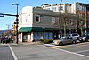 More images | |||
| Taylor Residence | 1653 Grand Boulevard, North Vancouver, BC | 49°18′49″N123°03′29″W / 49.3136°N 123.058°W | 2419 | | |||
| Tesky Residence | 244 East 10th Street, North Vancouver, BC | 49°19′02″N123°04′01″W / 49.3171°N 123.067°W | 6322 | | |||
| Vance Residence | 620 West 15th Street, North Vancouver, BC | 49°19′21″N123°05′20″W / 49.3225°N 123.089°W | 2416 | | |||
| Victoria Park | 650 Lonsdale Avenue, North Vancouver, BC | 49°19′01″N123°04′26″W / 49.3169°N 123.074°W | 2426 | 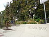 More images | |||
| Wright Residence | 146 East 3rd Street, North Vancouver, BC | 49°18′46″N123°04′30″W / 49.3129°N 123.075°W | 6204 | | |||
| Wynard and Charlotte Gladwin Residence | 260 Keith Road East, North Vancouver, BC | 49°18′54″N123°04′05″W / 49.3149°N 123.068°W | 6196 |  More images | |||
| Young Residence | 1312 Grand Boulevard, North Vancouver, BC | 49°19′12″N123°03′23″W / 49.3200°N 123.0564°W | 3816 | | |||
| Young Residence | 1753 Grand Boulevard, North Vancouver, BC | 49°19′29″N123°03′29″W / 49.3248°N 123.058°W | 2420 |  More images |