Related Research Articles

City status in the United Kingdom is granted by the monarch of the United Kingdom to a select group of communities: as of 2014, there are 69 cities in the United Kingdom – 51 in England, six in Wales, seven in Scotland and five in Northern Ireland. Although it carries no special rights, the status of city can be a marker of prestige and confer local pride.

A conurbation is a region comprising a number of metropolises, cities, large towns, and other urban areas that, through population growth and physical expansion, have merged to form one continuous urban or industrially developed area. In most cases, a conurbation is a polycentric urbanised area, in which transportation has developed to link areas to create a single urban labour market or travel to work area.
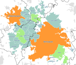
The West Midlands conurbation is the large conurbation that includes the cities of Birmingham and Wolverhampton and the towns of Sutton Coldfield, Dudley, Walsall, West Bromwich, Solihull, Stourbridge and Halesowen in the English West Midlands.
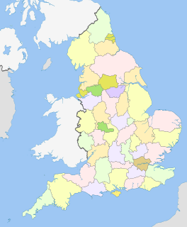
The counties and areas for the purposes of the lieutenancies, also referred to as the lieutenancy areas of England and informally known as ceremonial counties, are areas of England to which lords-lieutenant are appointed. Legally, the areas in England, as well as in Wales and Scotland, are defined by the Lieutenancies Act 1997 as "counties and areas for the purposes of the lieutenancies in Great Britain", in contrast to the areas used for local government. They are also informally known as "geographic counties", to distinguish them from other types of counties of England.
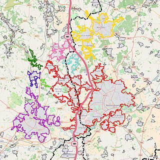
The Nottingham Built-up Area (BUA), Nottingham Urban Area, or Greater Nottingham is an area of land defined by the Office for National Statistics as which is built upon, with nearby areas linked if within 200 metres - see the List of urban areas in the United Kingdom article for a broader definition. It consists of the city of Nottingham and the adjoining urban areas of Nottinghamshire and Derbyshire, in the East Midlands of England. It had a total population of 729,977 at the time of the 2011 census. This was an increase of almost 10% since the 2001 census recorded population of 666,358,, due to population increases, reductions and several new sub-divisions.

Greater Glasgow is an urban settlement in Scotland consisting of all localities which are physically attached to the city of Glasgow, forming with it a single contiguous urban area. It does not relate to municipal government boundaries and its territorial extent is defined by the General Register Office for Scotland, which determines settlements in Scotland for census and statistical purposes. Greater Glasgow had a population of 1,199,629 at the time of the 2001 UK Census making it the largest urban area in Scotland and the fifth-largest in the United Kingdom. However, the population estimate for the Greater Glasgow 'settlement' in mid-2016 was 985,290 – the reduced figure explained by the removal of the Motherwell & Wishaw (124,790), Coatbridge & Airdrie (91,020) and Hamilton (83,730) settlement areas east of the city due to small gaps between the populated postcodes. The 'new towns' of Cumbernauld and East Kilbride (75,120) were never included in these figures despite their close ties to Glasgow due to having a clear geographical separation from the city.

South Hampshire is a term used mainly to refer to the metropolitan area formed by the cities of Portsmouth and Southampton and their suburbs and commuter towns, in southern Hampshire, England. The area had a population of around 1 million based on the 2001 census, and estimated population of over 1.5 million in 2013. It is the most populated part of South East England, excluding London. The area is sometimes referred to as Solent City particularly in relation to local devolution but the term is controversial.

The Greater Manchester Built-up Area is an area of land defined by the Office for National Statistics (ONS), consisting of the large conurbation that encompasses the urban element of the city of Manchester and the continuous metropolitan area that spreads outwards from it, forming much of Greater Manchester in North West England. According to the United Kingdom Census 2011, the Greater Manchester Built-up Area has a population of 2,553,379 making it the second most populous conurbation in the United Kingdom after the Greater London Built-up Area. This was an increase of 14% from the population recorded at the United Kingdom Census 2001 of 2,240,230, when it was known as the Greater Manchester Urban Area.

The demography of London is analysed by the Office for National Statistics and data is produced for each of the Greater London wards, the City of London and the 32 London boroughs, the Inner London and Outer London statistical sub-regions, each of the Parliamentary constituencies in London, and for all of Greater London as a whole. Additionally, data is produced for the Greater London Urban Area. Statistical information is produced about the size and geographical breakdown of the population, the number of people entering and leaving country and the number of people in each demographic subgroup.
The wards and electoral divisions in the United Kingdom are electoral districts at sub-national level represented by one or more councillors. The ward is the primary unit of English electoral geography for civil parishes and borough and district councils, electoral ward is the unit used by Welsh principal councils, while the electoral division is the unit used by English county councils and some unitary authorities. Each ward/division has an average electorate of about 5,500 people, but ward-population counts can vary substantially. As at the end of 2014 there were 9,456 electoral wards/divisions in the UK.

A Travel to Work Area or TTWA is a statistical tool used by UK Government agencies and local authorities, especially by the Department for Work and Pensions and Jobcentres, to indicate an area where the population would generally commute to a larger town, city or conurbation for the purposes of employment.

The demography of Greater Manchester is analysed by the Office for National Statistics and data is produced for each of its ten metropolitan boroughs, each of the Greater Manchester electoral wards, the NUTS3 statistical sub-regions, each of the Parliamentary constituencies in Greater Manchester, the 15 civil parishes in Greater Manchester, and for all of Greater Manchester as a whole; the latter of which had a population of 2,682,500 at the 2011 UK census. Additionally, data is produced for the Greater Manchester Urban Area. Statistical information is produced about the size and geographical breakdown of the population, the number of people entering and leaving country and the number of people in each demographic subgroup.
A Primary Urban Area (PUA) is an area defined by the Department for Communities and Local Government in the United Kingdom as a statistical tool for analysing the major cities of England, originating as part of their State of the English Cities report and database.
A census of the population of the United Kingdom is taken every ten years. The 2011 census was held in all countries of the UK on 27 March 2011. It was the first UK census which could be completed online via the Internet. The Office for National Statistics (ONS) is responsible for the census in England and Wales, the General Register Office for Scotland (GROS) is responsible for the census in Scotland, and the Northern Ireland Statistics and Research Agency (NISRA) is responsible for the census in Northern Ireland.
The Cannock Built-up Area is an area of land in the central southern part of Staffordshire in the West Midlands region of England defined by the United Kingdom Office for National Statistics (ONS) for population monitoring purposes. It is an urban conurbation centred on Cannock that is covered by the settlements listed in the table below. It is not conterminous with administrative boundaries. Two of the settlements are towns.
Towns and cities in England can be defined either by their local government administrative boundaries or by the physical extent of their built-up areas.

The Newport Built-up area is an area of land defined by the United Kingdom Office for National Statistics (ONS) for population monitoring purposes. It is an urban conurbation and is not coterminous with the city boundaries. It consists of the urban area centred on Newport as well as contiguous settlements in the eastern and western valleys extending north of the city – including Cwmbran, Pontypool, Risca, Abercarn and Blackwood. It does however exclude physically detached urban areas within the city boundaries, such as Marshfield.

Greater London is a ceremonial county of England that makes up the majority of the London region. This region forms the administrative boundaries of London and is organised into 33 local government districts—the 32 London boroughs and the City of London, which is located within the region but is separate from the county. The Greater London Authority, based in Southwark, is responsible for strategic local government across the region and consists of the Mayor of London and the London Assembly. The City of London Corporation is the principal local authority for the City of London, with a similar role to that of the 32 London borough councils.
References
- ↑ Office for National Statistics (2004). "Key Statistics for urban areas in the North" (PDF). The Stationery Office. p. 3. Archived from the original (PDF) on 2004-07-24. Retrieved 2011-01-11.
- ↑ Office for National Statistics