List of major snow and ice events in the United States

Last updated

The following is a list of major snow and ice events in the United States that have caused noteworthy damage and destruction in their wake. The categories presented below are not used to measure the strength of a storm, but are rather indicators of how severely the snowfall affected the population in the storm's path. Some information such as snowfall amounts or lowest pressure may be unavailable due to a lack of documentation. Winter storms can produce both ice and snow, but are usually more notable in one of these two categories. The "Maximum accumulation" sections reflect the more notable category which is represented in inches of snow unless otherwise stated. Only category 1 and higher storms as defined by their regional snowfall index are included here.

Contents

Regional Snowfall Index
CategoryRSI valueDescription
Five 18.0+    Extreme  
Four  10–18    Crippling  
Three  6–10    Major  
Two  3–6    Significant  
One  1–3    Notable  
Zero  <1.0    Nuisance  

Seasonal summaries

The following is a table that shows North American winter season summaries dating back to 2009. While there is no well-agreed-upon date used to indicate the start of winter in the Northern Hemisphere, there are two definitions of winter which may be used. The first is astronomical winter, which has the season starting on a date known as the winter solstice, often on or around December 21. The season lasts until the spring equinox, which often occurs on or around March 20. The second has to do with meteorological winter which varies with latitude for a start date. [1] Winter is often defined by meteorologists to be the three calendar months with the lowest average temperatures. Since both definitions span the start of the calendar year, it is possible to have a winter storm occur two different years.

Winter SeasonMaximum accumulationNumber of RSI events
2009–2010 53 inches (130 cm)
(February 25–27, 2010)
7
2010–2011 50 inches (130 cm)
(January 16–20, 2012)
10
2011–2012 53 inches (130 cm)
(February 25–27, 2010)
3
2012–2013 40 inches (100 cm)
(February 7–18, 2013)
9
2013–2014 58 inches (150 cm)
(October 3–7, 2013)
10
2014–2015 88 inches (220 cm)
(November 13–21, 2014)
9
2015–2016 51.3 inches (130 cm)
(April 15–23, 2016)
4
2016–2017 58 inches (150 cm)
(March 11–15, 2017)
4
2017–2018 39.3 inches (100 cm)
(March 1–3, 2018)
7
2018–2019 52 inches (130 cm)
(March 8–16, 2019)
8
2019–2020 114 inches (290 cm)
(Mid-March blizzard)
1
2020–2021 107 inches (270 cm)
(January 25–February 3, 2021)
6
2021–2022 60 inches (150 cm)
(December 13–18, 2021)
4
2022–2023 81.2 inches (206 cm)
(November 16–20, 2022)
3

18th–19th century

YearDateMaximum accumulationLowest pressureType
1717 [lower-alpha 1] February 27 – March 7 Storm
1804 October 4–11 48 inches (120 cm)977 hPa (28.9 inHg) [lower-alpha 2] Blizzard
1886 January 6–11 18.5 inches (47 cm) Blizzard
1888 January 12–13 6 inches (15 cm)
March 11–14 58 inches (150 cm)982 hPa (29.0 inHg)
1899 February 10–14 [2]

20th century

The Great Blizzard of 1978 was the most intense storm of the 20th century. Great Blizzard 1978-01-26 weather map.png
The Great Blizzard of 1978 was the most intense storm of the 20th century.
YearDateMaximum accumulationLowest pressureTypeCategory
(RSI)
1905 November 27–28 [3] 991 hPa (29.3 inHg) Storm
1913 November 6–11 24 inches (61 cm)968.5 hPa (28.60 inHg) Blizzard
1920 March 15–18 Blizzard
1922 January 27–29 BlizzardCategory 5
1940 November 10–12 27 inches (69 cm)971 hPa (28.7 inHg)Blizzard
1944 December 10-13 36 inches (91 cm)StormCategory 3
1947 December 25–26 26.4 inches (67 cm)BlizzardCategory 3
1950 November 24–30 57 inches (140 cm)978 hPa (28.9 inHg)BlizzardCategory 5
1952 February 17–18 Storm
1956 March 18–19 Blizzard
1958 March 18–21 StormCategory 3
1960 December 11–12 21.4 inches (54 cm)966 hPa (28.5 inHg)BlizzardCategory 2
1961 January 1–3 8 inches (20 cm) [lower-alpha 3] Ice storm
1963 October 25–30 48 inches (120 cm)948 hPa (28.0 inHg) [lower-alpha 4] Storm
1966 January 27–31 103 inches (260 cm)BlizzardCategory 4
1967 January 26–27 23 inches (58 cm)997 hPa (29.4 inHg)BlizzardCategory 5
1969 February 8–10 970 hPa (29 inHg)BlizzardCategory 2
March 5–8 Storm
December 25–28 976 hPa (28.8 inHg)Storm
1971 March 3–5 Blizzard
1973 December 16–17 1 inch (2.5 cm) [lower-alpha 3] 992 hPa (29.3 inHg)Ice storm
1975 January 9–12 27 inches (69 cm)961 hPa (28.4 inHg)BlizzardCategory 3
1976 February 2 56 inches (140 cm)957 hPa (28.3 inHg)Blizzard
1977 January 28 – February 1 100 inches (250 cm)Blizzard
1978 January 25–27 36 inches (91 cm)955.5 hPa (28.22 inHg)BlizzardCategory 5
February 5–7 40 inches (100 cm)BlizzardCategory 5
1979 January 13–14 21 inches (53 cm)BlizzardCategory 4
1991 October 31 – November 3 37 inches (94 cm)984 hPa (29.1 inHg)BlizzardCategory 5
1992 December 10–12 48 inches (120 cm)985 hPa (29.1 inHg)BlizzardCategory 2
1993 March 12–15 69 inches (180 cm)960 hPa (28 inHg)BlizzardCategory 5
1995 February 2–6 20 inches (51 cm)962 hPa (28.4 inHg)StormCategory 2
1996 January 6–10 48 inches (120 cm)980 hPa (29 inHg)BlizzardCategory 5
1997 March 31 – April 1 979 hPa (28.9 inHg)BlizzardCategory 2
October 24–26 Storm
1998 January 4–10 5 inches (13 cm) [lower-alpha 3] Ice storm
1999 January 2–4 21.6 inches (55 cm)StormCategory 4
January 14–15 Ice storm

21st century

The 2016 United States winter storm is the latest "Category 5" (Extreme) storm to hit the United States as classified by NOAA. January 2016 United States winter storm 2016-01-23 0715Z (alternate).jpg
The 2016 United States winter storm is the latest "Category 5" (Extreme) storm to hit the United States as classified by NOAA.

2000s

YearDateMaximum accumulationLowest pressureTypeCategory
(RSI)
2000 January 18–30 30 inches (76 cm)BlizzardCategory 3
December 27–31 30 inches (76 cm)StormCategory 2
2002 January 29–31 3 inches (7.6 cm) [lower-alpha 3] Ice storm Category 2
February 7 994 hPa (29.4 inHg) Storm
December 4–5 Ice storm
2003 February 14–19 44 inches (110 cm)999 hPa (29.5 inHg) Blizzard Category 4
December 5–8 35.6 inches (90 cm)992 hPa (29.3 inHg)BlizzardCategory 3
2004 December 21–24 39 inches (99 cm)984 hPa (29.1 inHg)StormCategory 4
December 24–28 18 inches (46 cm) [lower-alpha 5] 964 hPa (28.5 inHg)Storm
2005 January 20–23 40.5 inches (103 cm)BlizzardCategory 4
December 14–16 0.75 inches (1.9 cm) [lower-alpha 3] Ice storm
2006 February 11–13 30.2 inches (77 cm)971 hPa (28.7 inHg)BlizzardCategory 2
October 11–13 24 inches (61 cm)980 hPa (29 inHg)Storm
November 20–24 5 inches (13 cm) [lower-alpha 6] 944 hPa (27.9 inHg)Storm
November 26 – December 1 Storm
December 20–31 32 inches (81 cm) [lower-alpha 1] Blizzard
2007 January 11–24 4 inches (10 cm) [lower-alpha 3] 961 hPa (28.4 inHg)Ice stormCategory 2
February 12–20 48 inches (120 cm)970 hPa (29 inHg)BlizzardCategory 3
April 13–17 23 inches (58 cm)969 hPa (28.6 inHg)StormCategory 1
November 29 – December 4 14 inches (36 cm) [lower-alpha 1] 952 hPa (28.1 inHg)Storm
November 29 – December 5 44 inches (110 cm)976 hPa (28.8 inHg)Storm
December 8–18 24 inches (61 cm) [lower-alpha 1] 974 hPa (28.8 inHg)Various
2008 January 3–11 956 hPa (28.2 inHg)Blizzard
March 6–10 28.5 inches (72 cm)984 hPa (29.1 inHg)Blizzard
December 11–12 Ice storm
December 19–25 Storm
2009 January 25–30 2.5 inches (6.4 cm) [lower-alpha 3] 999 hPa (29.5 inHg)Ice storm
October 13–20 23 inches (58 cm)966 hPa (28.5 inHg)Blizzard
December 16–20 26.3 inches (67 cm)968 hPa (28.6 inHg)BlizzardCategory 4
December 22–28 40 inches (100 cm)985 hPa (29.1 inHg)BlizzardCategory 5

2010s

YearDateMaximum accumulationLowest pressureTypeCategory
(RSI)
2010 February 5–6 38.3 inches (97 cm)978 hPa (28.9 inHg) Blizzard Category 4
February 9–10 27.5 inches (70 cm)969 hPa (28.6 inHg)BlizzardCategory 2
February 25–27 53 inches (130 cm)972 hPa (28.7 inHg)BlizzardCategory 4
March 12–16 993 hPa (29.3 inHg) Storm
October 23–28 9 inches (23 cm)955.2 hPa (28.21 inHg)Blizzard
December 5–29 36 inches (91 cm)960 hPa (28 inHg)BlizzardCategory 2
2011 January 8–13 40.5 inches (103 cm)BlizzardCategory 2
January 25–27 BlizzardCategory 1
January 31 – February 2 27 inches (69 cm)996 hPa (29.4 inHg)BlizzardCategory 5
October 28 – November 1 32 inches (81 cm)971 hPa (28.7 inHg)BlizzardCategory 1
November 8–10 6.4 inches (16 cm)943 hPa (27.8 inHg)Blizzard
2012 January 16–20 50 inches (130 cm)992 hPa (29.3 inHg)Blizzard
October 29 – November 2 36 inches (91 cm)940 hPa (28 inHg) [lower-alpha 7] Storm
November 7–10 13.5 inches (34 cm)984 hPa (29.1 inHg)StormCategory 1
December 17–22 15.2 inches (39 cm)971 hPa (28.7 inHg)BlizzardCategory 2
December 25–28 27 inches (69 cm)968 hPa (28.6 inHg)BlizzardCategory 1
2013 February 7–18 40 inches (100 cm)968 hPa (28.6 inHg)BlizzardCategory 3
March 1–10 36 inches (91 cm)986 hPa (29.1 inHg)BlizzardCategory 2
October 3–5 58 inches (150 cm)999 hPa (29.5 inHg)BlizzardCategory 3
November 22-27 48 inches (120 cm) N/AStorm
December 19–23 14 inches (36 cm)997 hPa (29.4 inHg)Storm
2014 December 30 – January 6 23.8 inches (60 cm)936 hPa (27.6 inHg)StormCategory 2
January 19–24 18.3 inches (46 cm)962 hPa (28.4 inHg)BlizzardCategory 1
January 27–31 10 inches (25 cm)999 hPa (29.5 inHg)BlizzardCategory 1
February 11–24 27.5 inches (70 cm)968 hPa (28.6 inHg)BlizzardCategory 4
November 7–13 Blizzard
November 13–21 88 inches (220 cm)961 hPa (28.4 inHg)Storm
2015 January 23–30 36 inches (91 cm)970 hPa (29 inHg)BlizzardCategory 3
January 31 – February 2 24.1 inches (61 cm)978 hPa (28.9 inHg)BlizzardCategory 3
February 12–17 27.4 inches (70 cm)958 hPa (28.3 inHg)BlizzardCategory 1
March 1–6 54.6 inches (139 cm)993 hPa (29.3 inHg)Blizzard
November 24–27 1.5 inches (3.8 cm) [lower-alpha 3] 994 hPa (29.4 inHg) Ice storm
December 26–30 41 inches (100 cm)989 hPa (29.2 inHg)Blizzard
2016 January 21–24 42 inches (110 cm)983 hPa (29.0 inHg)BlizzardCategory 5
January 29 – February 7 41 inches (100 cm)BlizzardCategory 2
February 7–10 11 inches (28 cm)976 hPa (28.8 inHg)Blizzard
February 23–24 17 inches (43 cm)Storm
March 21–25 32.5 inches (83 cm)989 hPa (29.2 inHg)Blizzard
April 15–23 51.3 inches (130 cm)999 hPa (29.5 inHg)Blizzard
2017 January 4–8 56 inches (140 cm)987 hPa (29.1 inHg)BlizzardCategory 2
January 7–13, 19–24
February 8–22
Storm
January 10–17 1 inch (2.5 cm) [lower-alpha 3] 999 hPa (29.5 inHg)Ice storm
February 6–10 24 inches (61 cm)969 hPa (28.6 inHg)BlizzardCategory 1
February 12–15 40 inches (100 cm)968 hPa (28.6 inHg)Blizzard
March 11–15 58 inches (150 cm)974 hPa (28.8 inHg)BlizzardCategory 4
October 29-31 8.4 inches (21 cm)975 hPa (28.8 inHg)Storm
December 8-10 25 inches (64 cm)StormCategory 2
2018 January 2–4 22 inches (56 cm)949 hPa (28.0 inHg)BlizzardCategory 1
March 1–3 39.3 inches (100 cm)974 hPa (28.8 inHg)BlizzardCategory 1
March 6–8 36 inches (91 cm)986 hPa (29.1 inHg)BlizzardCategory 1
March 20–22 20.1 inches (51 cm)988 hPa (29.2 inHg)StormCategory 2
April 13–15 33 inches (84 cm)985 hPa (29.1 inHg)StormCategory 4
2019 January 16–21 52 inches (130 cm)StormCategory 1
February 11–13 26.5 inches (67 cm)Blizzard
March 8–16 52 inches (130 cm)968 hPa (28.6 inHg)BlizzardCategory 1
April 10–14 30 inches (76 cm)982 hPa (29.0 inHg)BlizzardCategory 3
November 26 – December 3 973 hPa (28.7 inHg)BlizzardCategory 2

2020s

YearDateMaximum accumulationLowest pressureTypeCategory
(RSI)
2020 January 15–18 37 inches (94 cm)979 hPa (28.9 inHg)Blizzard
February 2–5 23.5 inches (60 cm)943 hPa (27.8 inHg) [lower-alpha 8] Storm
February 9–13 13 inches (33 cm)920 hPa (27 inHg) [lower-alpha 9] Blizzard
October 29–30 6.5 inches (17 cm)970 hPa (29 inHg) [lower-alpha 10] Storm
November 29–December 2 24 inches (61 cm)989 hPa (29.2 inHg)Storm
December 4–6 18 inches (46 cm)976 hPa (28.8 inHg)Blizzard
December 14–18 44 inches (110 cm)995 hPa (29.4 inHg)StormCategory 2
December 30–January 2, 2021 24 inches (61 cm)1,001 hPa (29.6 inHg)StormCategory 1
2021 January 25–February 3 36.1 inches (92 cm)984 hPa (29.1 inHg)BlizzardCategory 3
February 6–8 14 inches (36 cm)960 hPa (28 inHg)Storm
February 13–17 26 inches (66 cm)960 hPa (28 inHg)BlizzardCategory 3
February 15–20 24 inches (61 cm)948 hPa (28.0 inHg)StormCategory 3
March 10–16 52.5 inches (133 cm)980 hPa (29 inHg)BlizzardCategory 3
March 16–17 6.2 inches (16 cm)997 hPa (29.4 inHg)Blizzard
April 15–17 14 inches (36 cm)988 hPa (29.2 inHg)Storm
2022 January 3-4 15.5 inches (39 cm)980 hPa (29 inHg)Storm
January 14–17 27.5 inches (70 cm)981 hPa (29.0 inHg)StormCategory 2
January 28–30 30.4 inches (77 cm)969 hPa (28.6 inHg)BlizzardCategory 1
February 1–5 37 inches (94 cm)1,004 hPa (29.6 inHg)StormCategory 2
February 22-26 12.2 inches (31 cm) N/AStorm
April 11-13 47 inches (120 cm)983 hPa (29.0 inHg)Storm
November 16–20 81.6 inches (207 cm)Storm
December 21–26 56.5 inches (144 cm)963 hPa (28.4 inHg)BlizzardCategory 4
2023 January 31 - February 2 N/A1,016 hPa (30.0 inHg)Storm
February 21-28 N/A N/ABlizzardCategory 2
March 9-15 42.1 inches (107 cm) N/AStormCategory 2

See also

Notes

  1. 1 2 3 4 This event included multiple different storms.
  2. The 1804 New England hurricane caused a major snow event.
  3. 1 2 3 4 5 6 7 8 9 Freezing rain
  4. Hurricane Ginny caused a major snow event.
  5. This storm was significant for its snow impact on Texas.
  6. While this nor'easter was not a major snow event, it was notable for the earliest snowfall ever recorded in Charleston, South Carolina and Savannah, Georgia.
  7. Hurricane Sandy caused a major snow event.
  8. Storm Ciara caused a major snow event.
  9. Storm Dennis caused a major snow event.
  10. Hurricane Zeta caused a moderate snow event.

Related Research Articles

<span class="mw-page-title-main">Blizzard</span> Type of snowstorm

A blizzard is a severe snowstorm characterized by strong sustained winds and low visibility, lasting for a prolonged period of time—typically at least three or four hours. A ground blizzard is a weather condition where snow is not falling but loose snow on the ground is lifted and blown by strong winds. Blizzards can have an immense size and usually stretch to hundreds or thousands of kilometres.

<span class="mw-page-title-main">Winter storm</span> Low-temperature extreme weather events of high winds and freezing precipitation forms

A winter storm is an event in which wind coincides with varieties of precipitation that only occur at freezing temperatures, such as snow, mixed snow and rain, or freezing rain. In temperate continental and subarctic climates, these storms are not necessarily restricted to the winter season, but may occur in the late autumn and early spring as well. A snowstorm with strong winds and other conditions meeting certain criteria is called a blizzard.

<span class="mw-page-title-main">North American blizzard of 2003</span>

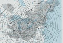
The Blizzard of 2003, also known as the Presidents' Day Storm II or simply PDII, was a historic and record-breaking snowstorm on the East Coast of the United States and Canada, which lasted from February 14 to February 19, 2003. It spread heavy snow across the major cities of the Northeastern and Mid-Atlantic states, making it the defining snowstorm of the very snowy winter of 2002–2003.

The Northeast snowfall impact scale (NESIS) was created to measure snowstorms in the U.S. Northeast in much the same way the Saffir–Simpson hurricane scale records hurricane intensity and the enhanced Fujita scale with tornadoes. This scale takes into account the very high population of the Northeast, and thus snowfall amounts are often smaller compared to what other areas of the USA would consider significant snowfall amounts.

This article describes severe weather terminology used by the Meteorological Service of Canada, a branch within Environment and Climate Change Canada. The article primarily describes various weather warnings, and their criteria. Related weather scales and general weather terms are also addressed in this article. Some terms are specific to certain regions.

The climate of Houston is classified as a humid subtropical climate, with tropical influences. August normally ranks as the warmest month at an average temperature of 84.6 °F (29.2 °C) and January the coldest month at an average temperature of 53.1 °F (11.7 °C).

The Climate of Beaumont, Texas covers the averages and extremes in past weather seen within the city of Beaumont, Texas. The city is within the humid subtropical climate regime, and is within the Piney Woods region of eastern Texas. The area around Beaumont receives the most rainfall in the state: more than 65 inches (1,700 mm) annually. Summers in the area are usually hot and humid, due to the moisture that flows inland off of the Gulf of Mexico. Winters are usually kept mild by the warm gulf waters. Hurricanes also pose a threat to the area. Hurricane Harvey in 2017, Hurricane Rita in 2005, and Hurricane Ike in 2008 were the most recent significant storms to strike.

<span class="mw-page-title-main">Climate of Allentown, Pennsylvania</span> Overview of the climate of Allentown, Pennsylvania, United States

The climate of Allentown, Pennsylvania is classified as a humid continental climate. Allentown's warmest month is July with a daily average temperature of 74.7 °F (23.7 °C) and the coldest month being January with a daily average of 29.4 °F (−1.4 °C). The average precipitation of Allentown is 45.35 inches (1,152 mm) per year.

<span class="mw-page-title-main">Geography of Atlanta</span>

The Geography of Atlanta encompasses 132.4 square miles (342.9 km2), of which 131.7 square miles (341.1 km2) is land and 0.7 square miles (1.8 km2) is water. The city is situated among the foothills of the Appalachian Mountains, and at 1,050 feet (320 m) above mean sea level, Atlanta has the highest elevation among major cities east of the Mississippi River. Atlanta straddles the Eastern Continental Divide, such that rainwater that falls on the south and east side of the divide flows into the Atlantic Ocean, while rainwater on the north and west side of the divide flows into the Gulf of Mexico. Atlanta sits atop a ridge south of the Chattahoochee River, which is part of the ACF River Basin. Located at the far northwestern edge of the city, much of the river's natural habitat is preserved, in part by the Chattahoochee River National Recreation Area.

<span class="mw-page-title-main">2013–14 North American winter</span>

The 2013–14 North American winter was one of the most significant for the United States, due in part to the breakdown of the polar vortex in November 2013, which allowed very cold air to travel down into the United States, leading to an extended period of very cold temperatures. The pattern continued mostly uninterrupted throughout the winter and numerous significant winter storms affected the Eastern United States, with the most notable one being a powerful winter storm that dumped ice and snow in the Southeastern United States and the Northeastern United States in mid-February. Most of the cold weather abated by the end of March, though a few winter storms did affect the Western United States towards the end of the winter.

<span class="mw-page-title-main">2015–16 North American winter</span>

The 2015–16 North American winter was not as frigid across North America and the United States as compared to the 2013–14 and 2014–15 winters. This was mainly due to a strong El Niño, which caused generally warmer-than-average conditions. However, despite the warmth, significant weather systems still occurred, including a snowstorm and flash flooding in Texas at the end of December and a large tornado outbreak at the end of February. The main event of the winter season, by far and large, was when a crippling and historic blizzard struck the Northeastern United States in late January, dumping up to 3 feet of snow in and around the metropolitan areas. Several other smaller snow events affected the Northeast as well, but for the most part the heaviest snowstorms and ice stayed out further west, such as a severe blizzard in western Texas in late December, and a major late-season snowstorm in Colorado in mid-April.

<span class="mw-page-title-main">2012–13 North American winter</span>

The 2012–13 North American winter started out somewhat early, as the remnants of Hurricane Sandy brought heavy snow to the mountains of West Virginia in late October. Later, a strong nor'easter affected the weary Northeastern United States, hampering storm recovery efforts and dropping several inches of snow. The rest of the winter featured several other notable events, such as a Christmas winter storm that affected most of the Eastern United States, and the most notable event occurring in early February, when a powerful blizzard struck the Northeast and brought record snow to some areas. During the winter, a weak El Nino was expected to influence weather conditions across the continent.

<span class="mw-page-title-main">2011–12 North American winter</span>

The 2011–12 North American winter by and large saw above normal average temperatures across North America, with the Contiguous United States encountering its fourth-warmest winter on record, along with an unusually low number of significant winter precipitation events. The primary outlier was Alaska, parts of which experienced their coldest January on record.

<span class="mw-page-title-main">2009–10 North American winter</span>

The 2009–10 North American winter saw several major blizzards affect the Northeastern United States. It refers to winter as it occurred across the North American continent from late 2009 to early 2010. While there is no well-agreed-upon date used to indicate the start of winter in the Northern Hemisphere, there are two definitions of winter which may be used. Based on the astronomical definition, winter begins at the winter solstice, which in 2009 occurred on December 21, and ends at the March equinox, which in 2010 occurred on March 20. Based on the meteorological definition, the first day of winter is December 1 and the last day February 28. Both definitions involve a period of approximately three months, with some variability.

<span class="mw-page-title-main">2010–11 North American winter</span>

The 2010–11 North American winter was influenced by an ongoing La Niña, seeing winter storms and very cold temperatures affect a large portion of the Continental United States, even as far south as the Texas Panhandle. Notable events included a major blizzard that struck the Northeastern United States in late December with up to 2 feet (24 in) of snowfall and a significant tornado outbreak on New Year's Eve in the Southern United States. By far the most notable event was a historic blizzard that impacted areas from Oklahoma to Michigan in early February. The blizzard broke numerous snowfall records, and was one of the few winter storms to rank as a Category 5 on the Regional Snowfall Index. In addition, Oklahoma set a statewide low temperature record in February.

<span class="mw-page-title-main">2016–17 North American winter</span>

The 2016–17 North American winter was quite warm across North America in general, due in part to a weak La Niña that was expected to influence weather conditions across the continent. Several notable events occurred during the season, including a potent winter storm that affected the East Coast of the United States in early January, the second-largest winter tornado outbreak on record later that month, and an unusually warm February. In addition, towards the end of the season, a large cyclonic storm system that caused a large tornado outbreak, flooding, and a potent blizzard occurred in the Heartland of the country. However, the most notable event of the winter was a powerful blizzard that impacted the Northeast and New England in mid-March, towards the end of the season.

<span class="mw-page-title-main">2017–18 North American winter</span> Weather summary

The 2017–18 North American winter saw weather patterns across North America that were very active, erratic, and protracted, especially near the end of the season, resulting in widespread snow and cold across the continent during the winter. Significant events included rare snowfall in the South, an outbreak of frigid temperatures that affected the United States during the final week of 2017 and early weeks of January, and a series of strong nor'easters that affected the Northeastern United States during the month of March. In addition, flooding also took place during the month of February in the Central United States. Finally the winter came to a conclusion with a powerful storm system that caused a tornado outbreak and blizzard in mid-April. The most intense event, however, was an extremely powerful cyclonic blizzard that impacted the Northeastern United States in the first week of 2018. Similar to the previous winter, a La Niña was expected to influence the winter weather across North America.

<span class="mw-page-title-main">2018–19 North American winter</span> North American winter of 2018–19

The 2018–19 North American winter was unusually cold within the Northern United States, with frigid temperatures being recorded within the middle of the season. Several notable events occurred, such as a rare snow in the Southeast in December, a strong cold wave and several major winter storms in the Midwest, and upper Northeast and much of Canada in late January and early February, record snowstorms in the Southwest in late February, deadly tornado outbreaks in the Southeast and a historic mid-April blizzard in the Midwest, but the most notable event of the winter was a record-breaking bomb cyclone that affected much of the Central United States and Canada in mid-March. Unlike previous winters, a developing weak El Niño was expected to influence weather patterns across North America. Overall, however, winter of 2018–19 was mild along the mid- and lower parts of the East Coast, the West Coast, and most of the southern Plains. Overall, the meteorological winter of 2018-19 became the wettest on record for the United States.

<span class="mw-page-title-main">2019–20 North American winter</span>

The 2019–20 North American winter was unusually warm for many parts of the United States; in many areas, neutral ENSO conditions controlled the weather patterns, resulting in the sixth-warmest winter on record, and many areas in the Northeastern United States saw one of the least snowy winters in years. In fact, Baltimore and Islip saw no snow in February for the first time. Some notable events still occurred, such as a powerful blizzard that impacted the Western United States in late November, a series of cold shots in January and February, a snowstorm within the Texas Panhandle and a late-season blizzard in the High Plains.

<span class="mw-page-title-main">2020–21 North American winter</span> Winter season in North America

The 2020–21 North American winter was the most significant winter season to affect North America in several years, and the costliest on record, with a damage total of at least $33.35 billion. The season featured 6 storms ranking on the Regional Snowfall Index scale (RSI), with 4 storms ranking as at least a Category 3. Most of the winter's damage and fatalities occurred due to a historic and major cold wave in mid-February. Several other significant events occurred, including a crippling early-season ice storm in the Southern Plains, a powerful nor'easter in mid-December, another major nor'easter in early February, two major and widespread winter storms in mid-February, and a major blizzard in the Rocky Mountains in mid-March. The winter-related events were responsible for at least 358 fatalities, making it the deadliest season since 1992–93. A La Niña pattern influenced much of the winter in North America.

References

  1. "Winter's Been Here Despite What the Calendar Says". NOAA Magazine. 22 December 2003. Archived from the original on 16 July 2011. Retrieved 22 December 2011.
  2. Griffin, Melissa (February 11, 2015). "The Great Blizzard of 1899". WeatherSTEM.
  3. C.P. Labadie. "Famous for all the wrong reasons". Duluth Seaway Port Authority. Archived from the original on June 8, 2010. Retrieved December 8, 2017.