Whistler Blackcomb is a ski resort located in Whistler, British Columbia, Canada. By many measures it is the largest ski resort in North America and has the greatest uphill lift capacity. It features the Peak 2 Peak Gondola for moving between Whistler and Blackcomb mountains at the top. With all of this capacity, Whistler Blackcomb is also often the busiest ski resort, often surpassing 2 million visitors a year.
Whistler is a resort municipality in the southern Pacific Ranges of the Coast Mountains in the unceded territories of Squamish, British Columbia. Approximately 125 km (78 mi) north of Vancouver and 36 km (22 mi) south of Pemberton, it is incorporated as the Resort Municipality of Whistler (RMOW). It has a permanent population of approximately 13,982 (2021), as well as a larger but rotating population of seasonal workers.

Mount Garibaldi is a dormant stratovolcano in the Garibaldi Ranges of the Pacific Ranges in southwestern British Columbia, Canada. It has a maximum elevation of 2,678 metres and rises above the surrounding landscape on the east side of the Cheakamus River in New Westminster Land District. Mount Garibaldi contains three summits, two of which are individually named. Atwell Peak is a sharp, conical summit slightly higher than the more rounded summit of Dalton Dome. Both summits were volcanically active at different times throughout Mount Garibaldi's eruptive history. The northern and eastern flanks of Mount Garibaldi are obscured by the Garibaldi Névé, a large snowfield containing several radiating glaciers. Flowing from the steep western face of Mount Garibaldi is the Cheekye River, a tributary of the Cheakamus River. Opal Cone on the southeastern flank is a small volcanic cone from which a lengthy lava flow descends. The western face is a landslide feature that formed in a series of collapses between 12,800 and 11,500 years ago. These collapses resulted in the formation of a large debris flow deposit that fans out into the Squamish Valley.
Highway 99, also known as the Fraser Delta Thruway south of Vancouver, and the Sea to Sky Highway, Squamish Highway, or Whistler Highway north of Vancouver, is the major north–south artery running through the Greater Vancouver area of British Columbia from the U.S. border, up Howe Sound through the Sea to Sky Country to Lillooet, and connecting to Highway 97 just north of Cache Creek. The highway's number was derived from the former U.S. Route 99, with which the highway originally connected to at the border. The highway currently connects with Interstate 5 at the United States border.
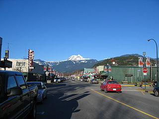
Squamish is a community and a district municipality in the Canadian province of British Columbia, located at the north end of Howe Sound on the Sea to Sky Highway. The population of the Squamish census agglomeration, which includes First Nation reserves of the Squamish Nation although they are not governed by the municipality, is 19,893.

The Squamish-Lillooet Regional District is a quasi-municipal administrative area in British Columbia, Canada. It stretches from Britannia Beach in the south to Pavilion in the north. Lillooet, Pemberton, Whistler and Squamish are the four municipalities in the regional district. Its administrative offices are in the Village of Pemberton, although the district municipalities of Squamish and Whistler are larger population centres. The district covers 16,353.68 km² of land area.

Garibaldi Provincial Park, also called Garibaldi Park, is a wilderness park located on the coastal mainland of British Columbia, Canada, 70 kilometres (43.5 mi) north of Vancouver. It was established in 1920 and named a Class A Provincial Park of British Columbia in 1927. The park is a popular destination for outdoor recreation, with over 30,000 overnight campers and over 106,000 day users in the 2017/2018 season.
Garibaldi, originally named Daisy Lake and also known as Garibaldi Lodge and Garibaldi Townsite, is a locality and ghost town in British Columbia, Canada, on the Cheakamus River around its confluence with Rubble Creek and just south of Daisy Lake. The CN railway and British Columbia Highway 99 traverses it north–south.

The Cheakamus River is a tributary of the Squamish River, beginning on the west slopes of Outlier Peak in Garibaldi Provincial Park upstream from Cheakamus Lake on the southeastern outskirts of the resort area of Whistler. The river flows into Cheakamus Lake before exiting it and flowing northwest until it turns south and enters Daisy Lake. Between the outlet of Daisy Lake and its mouth, much of its length is spent going through Cheakamus Canyon, where the river flows through swift rapids and even one good sized waterfall. The river flows south from the lake and through the canyon before joining the Squamish River at Cheekye, a few miles north of the town of Squamish. The river's name is an anglicization of the name of Chiyakmesh, a village of the Squamish people and a reserve of the Squamish Nation.

The Pacific Ranges are the southernmost subdivision of the Coast Mountains portion of the Pacific Cordillera. Located entirely within British Columbia, Canada, they run northwest from the lower stretches of the Fraser River to Bella Coola and Burke Channel, north of which are the Kitimat Ranges. The Coast Mountains lie between the Interior Plateau and the Coast of British Columbia.
The Garibaldi Ranges are the next-to-southwesternmost subdivision of the Pacific Ranges of the Coast Mountains; only the North Shore Mountains are farther southwest. They lie between the valley formed by the pass between the Cheakamus River and Green River on the west and the valley of the Lillooet River on the east, and extend south into Maple Ridge, an eastern suburb of Vancouver, and the northern District of Mission. To their south are the North Shore Mountains overlooking Vancouver while to their southeast are the Douglas Ranges.
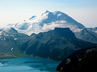
The Garibaldi Lake volcanic field is a volcanic field, located in British Columbia, Canada. It was formed by a group of nine small andesitic stratovolcanoes and basaltic andesite vents in the scenic Garibaldi Lake area immediately north of Mount Garibaldi was formed during the late Pleistocene and early Holocene. The oldest stratovolcano, The Black Tusk, formed between about 1.3 and 1.1 million years ago (Ma). Following glacial dissection, renewed volcanism produced the lava dome and flow forming its summit. Other Pleistocene vents are located along and to the west of the Cheakamus River. Cinder Cone, to the east of The Black Tusk, produced a 9-km-long lava flow during the late Pleistocene or early Holocene.

The Sea-to-Sky Corridor, often referred to as the Corridor or the Sea to Sky Country, is a region in British Columbia spreading from Horseshoe Bay through Whistler to the Pemberton Valley and sometimes beyond to include Birken and D'Arcy. From Whistler on up, the region overlaps with the older and more historic Lillooet Country, of which Squamish, at the region's centre, was once the southward extension in the days when it was the rail-port terminus from the Interior, via Lillooet, and accessible from the Lower Mainland only by sea. Most of the region is in the Squamish-Lillooet Regional District, although south of Britannia Beach a small part of the region is in the Greater Vancouver Regional District.
Alta Lake is a lake in the Resort Municipality of Whistler, British Columbia, Canada.
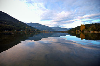
Green Lake is the largest and most northerly lake in the Resort Municipality of Whistler, British Columbia, Canada. It is the source of the Green River, a tributary of the Lillooet River, and is fed by the River of Golden Dreams, which issues from Alta Lake, which is at the height of land dividing the Green River drainage from that of the Cheakamus River to the south, which is a tributary of the Squamish River. Also feeding Green Lake are Fitzsimmons Creek, which originates in the valley above Whistler Village between Blackcomb and Whistler Mountains, and Rainbow Creek, which descends from Rainbow Mountain via the Alpine Meadows subdivision. A former minor ski hill, Rainbow, is located midway between Alpine Meadows and Emerald Estates near the lake's western extremity.
The Pemberton Icefield or Pemberton Icecap, is the southernmost of the series of very large icefields studding the Pacific Ranges of the southern Coast Mountains in British Columbia, Canada.
Birken is an unincorporated community on the north shore of Gates Lake in the Squamish-Lillooet region of southwestern British Columbia. On Pemberton Portage Road, the locality is by road about 182 kilometres (113 mi) north of Vancouver and 62 kilometres (39 mi) northeast of Whistler.
The Fitzsimmons Range is a small mountain range on the northwestern edge of the Garibaldi Ranges in southwestern British Columbia, Canada, located between the valleys of Cheakamus Lake (SW) and Fitzsimmons Creek (NE). Its most famous summit is Whistler Mountain, which overlooks the resort town of Whistler and is one of the two mountains forming the Whistler Blackcomb ski resort. Most of the range is within Garibaldi Provincial Park, while its northeastern extremity is part of the resort municipality, and of the lands associated with the ski resort operation. Other summits in the range include Oboe Summit, Piccolo Summit and Flute Summit, which are hillocks along the ridge running southeast from Whistler Mountain and were named in association with the renaming of Whistler. Beyond them is Singing Pass and Mount Fitzsimmons 2603 m (8540 ft) which is at the opposite end of the range from Whistler Mountain and the location of Fitzsimmons Glacier, which is the source of Fitzsimmons Creek.

Mount Cayley is an eroded but potentially active stratovolcano in the Pacific Ranges of southwestern British Columbia, Canada. Located 45 km (28 mi) north of Squamish and 24 km (15 mi) west of Whistler, the volcano resides on the edge of the Powder Mountain Icefield. It consists of massif that towers over the Cheakamus and Squamish river valleys. All major summits have elevations greater than 2,000 m (6,600 ft), Mount Cayley being the highest at 2,385 m (7,825 ft). The surrounding area has been inhabited by indigenous peoples for more than 7,000 years while geothermal exploration has taken place there for the last four decades.