
Shepparton is a city located on the floodplain of the Goulburn River in northern Victoria, Australia, approximately 181 kilometres (112 mi) north-northeast of Melbourne. As of June 2018 the estimated population of Shepparton, including the adjacent town of Mooroopna, was 51,631.
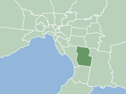
The City of Greater Dandenong is a local government area in Victoria, Australia in the southeastern suburbs of Melbourne. It has an area of just under 130 square kilometres and 166,094 residents in 2018. 29% of its land area forms part of the South East Green Wedge. It was formed in 1994 by the merger of parts of the former City of Dandenong and City of Springvale.
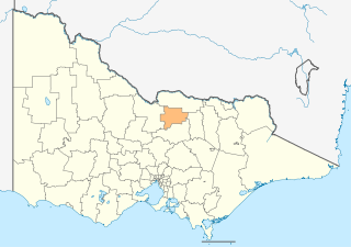
The City of Greater Shepparton is a local government area in the Hume region of Victoria, Australia, located in the north-east part of the state. It covers an area of 2,422 square kilometres (935 sq mi) and, in June 2018, had a population of 66,007. It includes the city of Shepparton and the towns of Arcadia, Ardmona, Congupna, Dookie, Grahamvale, Kialla, Lemnos, Merrigum, Mooroopna, Murchison, Tallygaroopna, Tatura, Toolamba and Undera. It was formed in 1994 from the amalgamation of the City of Shepparton, Shire of Shepparton, and parts of the Shire of Rodney, Shire of Euroa, Shire of Goulburn, Shire of Tungamah, Shire of Violet Town and Shire of Waranga.

Mooroopna is a rural town located 181 kilometres (112 mi) north of Melbourne, Victoria, Australia. It is on the banks of the Goulburn River opposite the larger town of Shepparton. The Midland Highway crosses the river between the two towns. At the 2016 census, Mooroopna had a population of 7,942.

Goulburn Valley Highway is a highway located in Victoria, Australia. The section north of the Hume Freeway is part of the Melbourne to Brisbane National Highway and is the main link between these two cities as well as a major link between Victoria and inland New South Wales. It is also the most direct route between Melbourne and the major regional centre of Shepparton in Victoria.

The Victorian Heritage Register (VHR) lists places deemed to be of cultural heritage significance to the State of Victoria, Australia. It has statutory weight under the Heritage Act 2017. The Minister for Planning is the responsible Minister. Heritage Victoria was established as the State Government listing and permit authority in 1995, replacing the original authority, the Historic Buildings Preservation Council, established in 1974. Listing on the Victorian Heritage Register is separate from listing by a local Council or Shire, known as a Heritage Overlay. Heritage Victoria is currently part of the Department of Environment, Land, Water and Planning of the Government of Victoria, Australia. Heritage Victoria reports to the Heritage Council who approve recommendations to the Register and hear appeals when a registration is disputed. The council also hears appeals by an owner to a permit issued by Heritage Victoria. As of 2021, there are over 2,400 places and objects listed on the VHR.

The Shire of Rodney was a local government area in the Goulburn Valley region, about 170 kilometres (106 mi) north of Melbourne, the state capital of Victoria, Australia, located between Kyabram and Shepparton. The shire covered an area of 1,009.92 square kilometres (389.9 sq mi), and existed from 1886 until 1994.

The Shire of Shepparton was a local government area in the Goulburn Valley region, about 180 kilometres (112 mi) north of Melbourne, the state capital of Victoria, Australia. The shire covered an area of 927.49 square kilometres (358.1 sq mi), and existed from 1884 until 1994. From 1927 onwards, Shepparton itself was managed by a separate entity, ultimately known as the City of Shepparton.

The City of Shepparton was a local government area in the Goulburn Valley region, about 180 kilometres (112 mi) north of Melbourne, the state capital of Victoria, Australia. The city covered an area of 26.71 square kilometres (10.3 sq mi), and existed from 1927 until 1994. It excluded areas such as Mooroopna and Kialla, which are now considered to be suburbs.
The Bunurong Land Council Aboriginal Corporation is a Registered Aboriginal Party and incorporated association representing the Bunurong community in the state of Victoria, Australia, particularly in matters relating to the Victorian Aboriginal Heritage Act 2006.


