This table shows an overview of the protected heritage sites in the Walloon town Arlon . This list is part of Belgium's national heritage.

Beschermd erfgoed is the official term to describe Flemish National Heritage Sites listed by law to protect and spread awareness of Belgian cultural heritage, specifically in Flanders. The term is also used nationwide to refer to national heritage sites. Because Belgium is officially a tri-lingual country, the other nationwide terms used in the rest of the country are the French term Bien classé and the German term Kulturdenkmal.

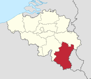
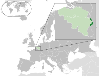
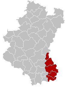
Arlon is a Walloon municipality of Belgium located in and capital of the province of Luxembourg. With a population of just over 28,000, it is the smallest provincial capital in Belgium. Arlon is also the capital of its cultural region: the Arelerland.
| Object | Year/architect | Town/section | Address | Coordinates | Number? | Image |
|---|---|---|---|---|---|---|
| Provincial palace and surroundings (nl)(fr) | Arlon | place Léopold n°1 | 49°40′58″N5°48′46″E / 49.682824°N 5.812677°E | 81001-CLT-0002-01 Info |  | |
| Castle Sterpenich (nl)(fr) | Arlon Sterpenich | rue de Berlaymont, Autelbas | 49°38′51″N5°53′20″E / 49.647411°N 5.888999°E | 81001-CLT-0003-01 Info |  | |
| Castle Autelbas (nl)(fr) | Arlon Autelbas | Neiewee | 49°38′49″N5°51′54″E / 49.64705°N 5.86505°E | 81001-CLT-0004-01 Info |  | |
| Castle Guirsch (nl)(fr) | Arlon | 49°43′08″N5°51′19″E / 49.719014°N 5.855268°E | 81001-CLT-0005-01 Info |  | ||
| Castle Guirsch extension to chateau (nl)(fr) | Arlon | rue du Château (S). | 49°43′10″N5°51′18″E / 49.719335°N 5.854910°E | 81001-CLT-0006-01 Info | 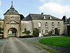 | |
| Chapel of St. Aubin de Heckbous (nl)(fr) | Arlon | Guirsch | 49°42′35″N5°51′46″E / 49.709767°N 5.862761°E | 81001-CLT-0007-01 Info |  | |
| Les Marais de Heinsch | Arlon | 49°41′38″N5°43′35″E / 49.693959°N 5.726252°E | 81001-CLT-0009-01 Info | 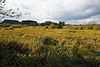 | ||
| Ossuary (nl)(fr) | Arlon | rue Dominique (actuellement rue Saint-Servais, devant le n°55) | 49°38′11″N5°46′20″E / 49.636266°N 5.772295°E | 81001-CLT-0010-01 Info |  | |
| Cross placed at roadside (nl)(fr) | Arlon | rue de Habergy, à gauche du n°1 | 49°38′09″N5°46′12″E / 49.635919°N 5.770082°E | 81001-CLT-0011-01 Info |  | |
| Ossuary in the graveyard of Udange (nl)(fr) | Arlon | 49°38′22″N5°45′42″E / 49.639563°N 5.761574°E | 81001-CLT-0012-01 Info |  | ||
| Ossuary (nl)(fr) | Arlon | rue Haute, links van nummer 56 | 49°39′09″N5°46′47″E / 49.652553°N 5.779790°E | 81001-CLT-0013-01 Info | 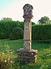 | |
| Stations of the Cross (nl)(fr) | Arlon | 49°38′25″N5°46′29″E / 49.640374°N 5.774672°E | 81001-CLT-0015-01 Info |  | ||
| Public toilet (nl)(fr) | Arlon | 49°41′56″N5°44′51″E / 49.698901°N 5.747556°E | 81001-CLT-0017-01 Info |  | ||
| Stations of the Cross (nl)(fr) | Arlon | rue de la Gendarmerie, face au n°8, à Sterpenich | 49°38′52″N5°53′25″E / 49.647741°N 5.890263°E | 81001-CLT-0022-01 Info | 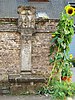 | |
| Stations of the Cross (nl)(fr) | Arlon | rue du Hämmelsmarsch, devant le n°32 | 49°39′04″N5°51′57″E / 49.651034°N 5.865937°E | 81001-CLT-0023-01 Info | 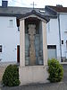 | |
| Stations of the Cross (nl)(fr) | Arlon | Sterpenich cemetery | 49°38′59″N5°53′20″E / 49.649629°N 5.888999°E | 81001-CLT-0024-01 Info |  | |
| Stations of the Cross (nl)(fr) | Arlon | rue du Centre across from number 6 | 49°40′58″N5°50′12″E / 49.682754°N 5.836784°E | 81001-CLT-0025-01 Info |  | |
| Stations of the Cross (nl)(fr) | Arlon | 23 rue de Hondelange | 49°39′03″N5°50′32″E / 49.650890°N 5.842245°E | 81001-CLT-0026-01 Info | ||
| Stations of the Cross (nl)(fr) | Arlon | De Cle des Champs, in front of number 3 | 49°39′30″N5°50′14″E / 49.658372°N 5.837184°E | 81001-CLT-0027-01 Info |  | |
| Stations of the Cross (nl)(fr) | Arlon | Grubermühle | 49°43′23″N5°50′13″E / 49.722928°N 5.837051°E | 81001-CLT-0028-01 Info |  | |
| Stations of the Cross (nl)(fr) | Arlon | Heckbous-Guirsch | 49°43′14″N5°51′27″E / 49.720588°N 5.857557°E | 81001-CLT-0029-01 Info |  | |
| Stations of the Cross (nl)(fr) | Arlon | corner of rue de la Sablière and Fouche road | 49°41′06″N5°42′42″E / 49.685016°N 5.711800°E | 81001-CLT-0030-01 Info |  | |
| Stations of the Cross (nl)(fr) | Arlon | vallée des Trois Moulins | 49°42′22″N5°51′03″E / 49.706089°N 5.850906°E | 81001-CLT-0031-01 Info |  | |
| Stations of the Cross (nl)(fr) | Arlon | rue de Hachy, near number 95 | 49°41′35″N5°41′42″E / 49.693086°N 5.695096°E | 81001-CLT-0032-01 Info | 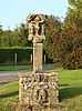 | |
| Trail to St. Donat (nl)(fr) | Arlon | 49°41′03″N5°48′57″E / 49.684129°N 5.815854°E | 81001-CLT-0033-01 Info | 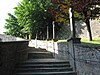 | ||
| Old house (nl)(fr) | Arlon | avenue de la Gare, 29 | 49°40′50″N5°48′37″E / 49.680610°N 5.810376°E | 81001-CLT-0034-01 Info |  | |
| Parts of building called "Les Caves" (nl)(fr) | Arlon | Grand-Rue, 57 | 49°40′59″N5°48′58″E / 49.682961°N 5.816242°E | 81001-CLT-0035-01 Info | ||
| Du Landbrough House (nl)(fr) | Arlon | 49°39′17″N5°41′01″E / 49.654740°N 5.683657°E | 81001-CLT-0039-01 Info |  | ||
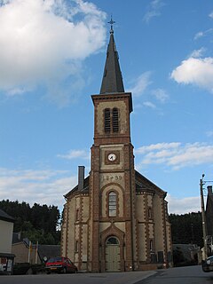
| St. Martin's church (nl)(fr) | 1907-1914 | Arlon | 49°40′58″N5°48′33″E / 49.682656°N 5.809241°E | 81001-CLT-0040-01 Info |  | |
| Synagogue (nl)(fr) | Arlon | rue Saint Jean | 49°40′59″N5°49′07″E / 49.683115°N 5.818718°E | 81001-CLT-0041-01 Info | 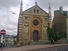 | |
| Old church of St. Martin and Gallo-Roman ruins (nl)(fr) | Arlon | rue de Thermes | 49°40′51″N5°49′02″E / 49.680738°N 5.817102°E | 81001-CLT-0042-01 Info |  | |
| Center of the village of Guirsch (nl)(fr) | Arlon | 49°43′03″N5°51′07″E / 49.717552°N 5.851842°E | 81001-CLT-0043-01 Info |  | ||
| parts of the building "Les Caves" (nl)(fr) | Arlon | 49°40′59″N5°48′58″E / 49.682961°N 5.816242°E | 81001-PEX-0001-01 Info | |||
| Church of St. Martin excepting the organ (nl)(fr) | Arlon | 49°40′58″N5°48′33″E / 49.682656°N 5.809241°E | 81001-PEX-0002-01 Info | | ||
| Du Landbrough (nl)(fr) | Arlon | 49°39′17″N5°41′01″E / 49.654740°N 5.683657°E | 81001-PEX-0003-01 Info |