This table shows an overview of the protected heritage sites in the Flemish town Beringen, Belgium . This list is part of Belgium's national heritage.

Beschermd erfgoed is the official term to describe Flemish National Heritage Sites listed by law to protect and spread awareness of Belgian cultural heritage, specifically in Flanders. The term is also used nationwide to refer to national heritage sites. Because Belgium is officially a tri-lingual country, the other nationwide terms used in the rest of the country are the French term Bien classé and the German term Kulturdenkmal.

Beringen is a city and municipality located in the Belgian province of Limburg The Beringen municipality includes the town of Beringen proper and the old communes of Beverlo, Koersel, and Paal.
| Object | Status? | Year/architect | Town/section | Address | Coordinates | Number? | Image |
|---|---|---|---|---|---|---|---|
| Watermill, "Holy Ghost Mill" (nl)(fr) | Beringen | Beekstraat 50 | 51°02′38″N5°12′21″E / 51.04381°N 5.20592°E | 21407 Info | |||
| Chapel of Broekhoven Smeedkapel (nl)(fr) | Beringen | Broekhovenstraat | 51°02′38″N5°13′39″E / 51.04391°N 5.22752°E | 21408 Info | |||
| Former cafe "The Crown" (nl)(fr) | Beringen | Brugstraat 1 | 51°02′54″N5°13′12″E / 51.04833°N 5.21989°E | 21409 Info | |||
| Former cafe "The Crown" (nl)(fr) | Beringen | Brugstraat 3 | 51°02′54″N5°13′12″E / 51.04833°N 5.21989°E | 21409 Info | |||
| Watermill and mill house (nl)(fr) | Beringen | Brulmolenstraat 2 | 51°03′07″N5°13′36″E / 51.05197°N 5.22671°E | 21410 Info | |||
| Soldiers Chapel of 1915 (nl)(fr) | Beringen | Everselstraat | 51°02′21″N5°13′48″E / 51.03921°N 5.23005°E | 21411 Info | |||
| Corner house "Saint Anthony" of 1634 (nl)(fr) | Beringen | Hoogstraat 5 | 51°02′53″N5°13′24″E / 51.04806°N 5.22340°E | 21413 Info | |||
| St. Peter in Chains Church (nl)(fr) | Beringen | Markt 6 | 51°02′54″N5°13′30″E / 51.04838°N 5.22489°E | 21415 Info | 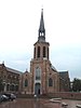 | ||
| Farm (former) (nl)(fr) | Beringen | Markt 7 | 51°02′54″N5°13′31″E / 51.04824°N 5.22523°E | 21417 Info | |||
| Property in eclectic style (nl)(fr) | Beringen | Markt 11 | 51°02′52″N5°13′33″E / 51.04786°N 5.22570°E | 21418 Info | |||
| Neoclassical house, now pub (nl)(fr) | Beringen | Markt 17 | 51°02′51″N5°13′29″E / 51.04763°N 5.22476°E | 21419 Info | |||
| Kapelanie (former) (nl)(fr) | Beringen | Markt 18 | 51°02′51″N5°13′29″E / 51.04763°N 5.22462°E | 21420 Info | |||
| Empire-style dwelling (nl)(fr) | Beringen | Markt 20 | 51°02′52″N5°13′28″E / 51.04764°N 5.22437°E | 21421 Info |  | ||
| Neoclassical corner house (nl)(fr) | Beringen | Markt 23 | 51°02′53″N5°13′26″E / 51.04792°N 5.22376°E | 21422 Info | |||
| Parish Church Saint-Lambert (nl)(fr) | Beringen | Beverlo-Dorp | 51°05′14″N5°13′13″E / 51.08721°N 5.22018°E | 21423 Info |  | ||
| Neoclassical mansion (nl)(fr) | Beringen | Beverlo-Dorp 19 | 51°05′17″N5°13′16″E / 51.08802°N 5.22113°E | 21424 Info | |||
| Mattress Factory, former wolweverij (nl)(fr) | Beringen | Eindekenstraat 45 | 51°05′38″N5°13′38″E / 51.09399°N 5.22726°E | 21426 Info | |||
| Long stretched farm (nl)(fr) | Beringen | Korspelsesteenweg 104 | 51°05′20″N5°14′07″E / 51.08891°N 5.23540°E | 21427 Info | |||
| Saint Anthony's Chapel of 1680 (nl)(fr) | Beringen | Groenhoekstraat | 51°05′19″N5°14′52″E / 51.08866°N 5.24791°E | 21428 Info | |||
| St. Bridget Parish (nl)(fr) | Beringen | Kerkplein 2 | 51°03′32″N5°16′22″E / 51.05901°N 5.27282°E | 21431 Info |  | ||
| House, double house (nl)(fr) | Beringen | Koersel-Dorp 6 | 51°03′33″N5°16′23″E / 51.05917°N 5.27316°E | 21432 Info | |||
| double house (nl)(fr) | Beringen | Koersel-Dorp 8 | 51°03′33″N5°16′23″E / 51.05917°N 5.27316°E | 21432 Info | |||
| section house of 1851 (nl)(fr) | Beringen | Koersel-Dorp 25 | 51°03′32″N5°16′26″E / 51.05885°N 5.27376°E | 21434 Info | |||
| elongated farm (nl)(fr) | Beringen | Leemstraat | 51°04′16″N5°17′59″E / 51.07111°N 5.29963°E | 21435 Info | |||
| Watermill, "Vurtense mill" (nl)(fr) | Beringen | Molendijk 103 | 51°03′30″N5°14′33″E / 51.05828°N 5.24261°E | 21438 Info | |||
| Farm (nl)(fr) | Beringen | Pannehoefstraat 31 | 51°04′01″N5°17′43″E / 51.06696°N 5.29534°E | 21439 Info | |||
| Farm (nl)(fr) | Beringen | Pannehoefstraat 33 | 51°04′01″N5°17′43″E / 51.06696°N 5.29534°E | 21439 Info | |||
| Farm (nl)(fr) | Beringen | Pannehoefstraat 35 | 51°04′01″N5°17′43″E / 51.06696°N 5.29534°E | 21439 Info | |||
| St. Joseph Chapel (nl)(fr) | Beringen | Pastorijstraat | 51°03′42″N5°16′26″E / 51.06164°N 5.27379°E | 21440 Info | |||
| Our Lady Chapel (nl)(fr) | Beringen | Pastorijstraat | 51°03′38″N5°16′44″E / 51.06043°N 5.27879°E | 21441 Info | |||
| Castle "Quanonen" (former) (nl)(fr) | Beringen | Pastorijstraat 2 | 51°03′39″N5°16′15″E / 51.06091°N 5.27079°E | 21442 Info | |||
| Long stretched farm (nl)(fr) | Beringen | Pastorijstraat 29 | 51°03′41″N5°16′28″E / 51.06140°N 5.27448°E | 21443 Info | |||
| Rectory (nl)(fr) | Beringen | Pastorijstraat 49 | 51°03′40″N5°16′35″E / 51.06119°N 5.27645°E | 21444 Info | |||
| Our Lady Chapel (nl)(fr) | Beringen | Trompetstraat | 51°03′15″N5°15′15″E / 51.05408°N 5.25412°E | 21450 Info | |||
| Chapel of Our Lady-to-the-Stake of 1833 (nl)(fr) | Beringen | Fonteintjestraat 18 | 51°04′59″N5°19′20″E / 51.08300°N 5.32221°E | 21451 Info | |||
| Chapel of Our Lady of Peace- (nl)(fr) | Beringen | Heerbaan | 51°04′19″N5°14′59″E / 51.07206°N 5.24964°E | 21453 Info | |||
| Watermill "Stalse Mill" (nl)(fr) | Beringen | Stalse Molenstraat 20 | 51°03′48″N5°14′42″E / 51.06338°N 5.24510°E | 21457 Info | |||
| section house (nl)(fr) | Beringen | Beverlosesteenweg 1 | 51°02′27″N5°10′20″E / 51.04071°N 5.17227°E | 21458 Info | |||
| Parish Church of St John the Baptist (nl)(fr) | Beringen | Paal-Dorp | 51°02′22″N5°10′24″E / 51.03934°N 5.17325°E | 21461 Info | |||
| Corner (nl)(fr) | Beringen | Pater Carremansstraat 2 | 51°02′20″N5°10′23″E / 51.03888°N 5.17295°E | 21462 Info | |||
| House with barn transverse (nl)(fr) | Beringen | Schoolstraat 26 | 51°02′18″N5°10′31″E / 51.03825°N 5.17540°E | 21464 Info | |||
| House with barn transverse (nl)(fr) | Beringen | Schoolstraat 28 | 51°02′18″N5°10′31″E / 51.03825°N 5.17540°E | 21464 Info | |||
| Watermill, "Gestelse mill" (nl)(fr) | Beringen | Maalbeekstraat 101 | 51°01′45″N5°11′32″E / 51.02913°N 5.19222°E | 21472 Info | |||
| elongated farm (nl)(fr) | Beringen | Sint-Janstraat 42 | 51°02′15″N5°10′36″E / 51.03760°N 5.17677°E | 21473 Info | |||
| Parish of Our Lady Immaculate-Received (nl)(fr) | Beringen | Pastoor Grausstraat | 51°03′42″N5°11′53″E / 51.06153°N 5.19810°E | 21474 Info | |||
| Road chapel (nl)(fr) | Beringen | Schipperstraat | 51°03′57″N5°11′58″E / 51.06583°N 5.19932°E | 21475 Info | |||
| Long stretched farm XIX (nl)(fr) | Beringen | Schipperstraat 25 | 51°03′54″N5°11′54″E / 51.06508°N 5.19832°E | 21476 Info | |||
| Parish Church St. Theodardus (nl)(fr) | Beringen | Koolmijnlaan | 51°04′33″N5°13′16″E / 51.07576°N 5.22110°E | 21477 Info |  | ||
| Sacred Heart Parish (nl)(fr) | Beringen | Kroonstraat | 51°05′23″N5°14′59″E / 51.08962°N 5.24960°E | 83613 Info |  | ||
| Shafts, shaft towers and buildings pickup (nl)(fr) | Beringen | Koolmijnlaan | 51°04′05″N5°13′24″E / 51.06801°N 5.22328°E | 200555 Info |  | ||
| Reception buildings (nl)(fr) | Beringen | Koolmijnlaan | 51°04′10″N5°13′22″E / 51.06939°N 5.22285°E | 200556 Info | |||
| Coal washing and kolenzeverij (nl)(fr) | Beringen | Koolmijnlaan | 51°04′11″N5°13′26″E / 51.06960°N 5.22399°E | 200557 Info |  | ||
| Stone Deposit (nl)(fr) | Beringen | Koolmijnlaan | 51°04′10″N5°13′38″E / 51.06944°N 5.22735°E | 200558 Info |  | ||
| Stone Deposit (nl)(fr) | Beringen | Koolmijnlaan | 51°04′10″N5°13′38″E / 51.06944°N 5.22735°E | 200558 Info | |||
| Electric central (nl)(fr) | Beringen | Koolmijnlaan | 51°04′08″N5°13′22″E / 51.06886°N 5.22270°E | 200560 Info | |||
| Cooling towers (nl)(fr) | Beringen | Koolmijnlaan | 51°04′04″N5°13′19″E / 51.06783°N 5.22192°E | 200561 Info |  | ||
| Central Water (nl)(fr) | Beringen | Koolmijnlaan | 51°04′04″N5°13′21″E / 51.06791°N 5.22246°E | 200562 Info | 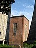 | ||
| Concrete clear ponds (nl)(fr) | Beringen | Koolmijnlaan | 51°03′53″N5°13′29″E / 51.06464°N 5.22475°E | 200563 Info | |||
| Work houses (nl)(fr) | Beringen | Koolmijnlaan | 51°04′01″N5°13′24″E / 51.06699°N 5.22327°E | 200564 Info |  | ||
| Passerelle and water tower (nl)(fr) | Beringen | Stationsstraat | 51°04′23″N5°13′26″E / 51.07313°N 5.22394°E | 200566 Info | |||
| Coal Harbour (nl)(fr) | Beringen | Olmsesteenweg | 51°04′08″N5°11′45″E / 51.06882°N 5.19595°E | 200567 Info | |||
| Central offices (nl)(fr) | Beringen | Koolmijnlaan | 51°04′12″N5°13′19″E / 51.07003°N 5.22207°E | 200568 Info | | ||
| Changing rooms and showers (nl)(fr) | Beringen | Koolmijnlaan | 51°04′13″N5°13′21″E / 51.07040°N 5.22260°E | 200569 Info |  | ||
| Fence, control building, dining room and locker room building and social (nl)(fr) | Beringen | Koolmijnlaan | 51°04′16″N5°13′15″E / 51.07115°N 5.22096°E | 200571 Info | 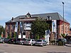 | ||
| Fence, control building, dining room and locker room building and social (nl)(fr) | Beringen | Koolmijnlaan | 51°04′16″N5°13′15″E / 51.07115°N 5.22096°E | 200571 Info | |||
| Fence, control building, dining room and locker room building and social (nl)(fr) | Beringen | Koolmijnlaan | 51°04′16″N5°13′15″E / 51.07115°N 5.22096°E | 200571 Info | |||
| Directors and engineering properties (nl)(fr) | Beringen | Koolmijnlaan 152 | 51°03′48″N5°13′15″E / 51.06326°N 5.22097°E | 200572 Info |  | ||
| Directors and engineering properties (nl)(fr) | Beringen | Koolmijnlaan 158 | 51°03′48″N5°13′15″E / 51.06326°N 5.22097°E | 200572 Info | |||
| Directors and engineering properties (nl)(fr) | Beringen | Koolmijnlaan 162 | 51°03′48″N5°13′15″E / 51.06326°N 5.22097°E | 200572 Info |  | ||
| Directors and engineering properties (nl)(fr) | Beringen | Koolmijnlaan 164 | 51°03′48″N5°13′15″E / 51.06326°N 5.22097°E | 200572 Info | |||
| Directors and engineering properties (nl)(fr) | Beringen | Koolmijnlaan 166 | 51°03′48″N5°13′15″E / 51.06326°N 5.22097°E | 200572 Info | |||
| Directors and engineering properties (nl)(fr) | Beringen | Koolmijnlaan 168 | 51°03′48″N5°13′15″E / 51.06326°N 5.22097°E | 200572 Info | |||
| Directors and engineering properties (nl)(fr) | Beringen | Koolmijnlaan 170 | 51°03′48″N5°13′15″E / 51.06326°N 5.22097°E | 200572 Info | |||
| Directors and engineering properties (nl)(fr) | Beringen | Koolmijnlaan 172 | 51°03′48″N5°13′15″E / 51.06326°N 5.22097°E | 200572 Info | |||
| Directors and engineering properties (nl)(fr) | Beringen | Koolmijnlaan 174 | 51°03′48″N5°13′15″E / 51.06326°N 5.22097°E | 200572 Info | |||
| Directors and engineering properties (nl)(fr) | Beringen | Koolmijnlaan 176 | 51°03′48″N5°13′15″E / 51.06326°N 5.22097°E | 200572 Info | |||
| Directors and engineering properties (nl)(fr) | Beringen | Koolmijnlaan 178 | 51°03′48″N5°13′15″E / 51.06326°N 5.22097°E | 200572 Info | |||
| Directors and engineering properties (nl)(fr) | Beringen | Koolmijnlaan 180 | 51°03′48″N5°13′15″E / 51.06326°N 5.22097°E | 200572 Info | |||
| Directors and engineering properties (nl)(fr) | Beringen | Koolmijnlaan 182 | 51°03′48″N5°13′15″E / 51.06326°N 5.22097°E | 200572 Info | |||
| Directors and engineering properties (nl)(fr) | Beringen | Koolmijnlaan 184 | 51°03′48″N5°13′15″E / 51.06326°N 5.22097°E | 200572 Info | |||
| Directors and engineering properties (nl)(fr) | Beringen | Koolmijnlaan 186 | 51°03′48″N5°13′15″E / 51.06326°N 5.22097°E | 200572 Info | |||
| Directors and engineering properties (nl)(fr) | Beringen | Koolmijnlaan 188 | 51°03′48″N5°13′15″E / 51.06326°N 5.22097°E | 200572 Info |  | ||
| Directors and engineering properties (nl)(fr) | Beringen | Koolmijnlaan 190 | 51°03′48″N5°13′15″E / 51.06326°N 5.22097°E | 200572 Info | |||
| Directors and engineering properties (nl)(fr) | Beringen | Koolmijnlaan 192 | 51°03′48″N5°13′15″E / 51.06326°N 5.22097°E | 200572 Info |  | ||
| Directors and engineering properties (nl)(fr) | Beringen | Koolmijnlaan 194 | 51°03′48″N5°13′15″E / 51.06326°N 5.22097°E | 200572 Info | |||
| Directors and engineering properties (nl)(fr) | Beringen | Koolmijnlaan 196 | 51°03′48″N5°13′15″E / 51.06326°N 5.22097°E | 200572 Info | |||
| Directors and engineering properties (nl)(fr) | Beringen | Koolmijnlaan 198 | 51°03′48″N5°13′15″E / 51.06326°N 5.22097°E | 200572 Info |  | ||
| Directors and engineering properties (nl)(fr) | Beringen | Koolmijnlaan 200 | 51°03′48″N5°13′15″E / 51.06326°N 5.22097°E | 200572 Info | |||
| Directors and engineering properties (nl)(fr) | Beringen | Koolmijnlaan 206 | 51°03′48″N5°13′15″E / 51.06326°N 5.22097°E | 200572 Info | |||
| Railways (nl)(fr) | Beringen | Koolmijnlaan | 201200 Info |
| Object | Status? | Year/architect | Town/section | Address | Coordinates | Number? | Image |
|---|---|---|---|---|---|---|---|
| Coalmine in Beringen (nl)(fr) | Beringen | Koolmijnlaan 201-203 | 20883 Info | ||||
| Coalmine of Beringen: Tuinwijk (nl)(fr) | Beringen | Aakstraat 1-3 Alfred Habetslaan 2-40 Berkenstraat 1-23 en 2-28 Beverlosesteenweg 444-454 en 445-451 Bootstraat 1-11 Duinenstraat 1-9 en 2-8 Dwarsstraat 1-23 en 2-16 Eeuwfeestplein 1-33 en 2-40 Gouden Jubileumplein 1-23 en 2-24 Havenlaan 3-7 en 68-134 Hotelstraat 1-9 en 2-8 Kanaalstraat 1-75 en 2-34 Kastanjestraat 1-9 en 2-20 Kioskplein 1-25 en 2-28 Klimopstraat 1, 2-24 Koolmijnlaan 152, 158, 162-224 en 337-343 Krommestraat 1-3, 2-8 Laan op Vurten 1-135 en 2-130 Leysestraat 1-135 en 2-130 Lindestraat 1-5 en 2-6 Louis Sauvestrelaan 1-67 en 2-92 Mijnschoolstraat 84-88 Oosterspeelplein Plataanstraat 1-7 en 2-8 Randstraat 8-20 Rondplein 1-23, Sorbebomenstraat 1-7 en 2-14 Spoorwegstraat 1-7 en 2-24 Stadionlaan 1-83 en 2-62 Stationkaai 1-59 Stationsstraat 59-111 en 84-110 Tennisstraat 1-39 en 2-16 Visvangststraat 24-46 Vossenbergstraat 1-31 Watersportlaan 1-15 en 2-16 Westerspeelplein 2-8 Wilgenstraat 1-21 en 2-20 Zandhoefstraat 1-25 en 2-4 | 22159 Info | ||||
| Coalmine of Beringen: Tuinwijk of Koersel (nl)(fr) | Beringen | Aakstraat 1-3 en 2-4 Beverlosesteenweg 444-454 en 445-451 Bootstraat 1-11 Eeuwfeestplein 1-33 en 2-40 Gouden Jubileumplein 1-23 en 2-24 Havenlaan 3-7 en 68-134 Kanaalstraat 1-75 en 2-34 Kioskplein 1-25 en 2-28 Koolmijnlaan 206-224 Krommestraat 1-3 en 2-8 Mijnschoolstraat 84-88 Stadionlaan 1-83 en 2-62 Tennisstraat 1-39 en 2-16 Visvangststraat 24-46 Watersportlaan 1-15 en 2-16 Zandhoefstraat 1-25 en 2-4 | 22199 Info | ||||
| Coalmine of Beringen: Tuinwijk Beverlo (nl)(fr) | Beringen | Alfred Habetslaan 2-40 Berkenstraat 1-23 en 2-28 Duinenstraat 1-9 en 2-8 Dwarsstraat 1-23 en 2-16 Hotelstraat 1-9 en 2-8 Kastanjestraat 1-9 en 2-20 Klimopstraat 1 en 2-24 Koolmijnlaan 337-343 Laan op Vurten 1-135 en 2-130 Leysestraat 69-111 Lindestraat 1-5 en 2-6 Louis Sauvestrelaan 1-67 en 2-92 Oosterspeelplein Plataanstraat 1-7 en 2-8 Randstraat 8-20 Rondplein 1-23 Sorbebomenstraat 1-7 en 2-14 Spoorwegstraat 1-7 en 2-24 Stationkaai 1-59 Stationsstraat 59-111 en 84-110 Vossenbergstraat 1-31 Westerspeelplein 2-8 Wilgenstraat 1-21 en 2-20 | 22201 Info |


