This table shows an overview of the protected heritage sites in the Flemish town Bocholt, Belgium . This list is part of Belgium's national heritage.

Beschermd erfgoed is the official term to describe Flemish National Heritage Sites listed by law to protect and spread awareness of Belgian cultural heritage, specifically in Flanders. The term is also used nationwide to refer to national heritage sites. Because Belgium is officially a tri-lingual country, the other nationwide terms used in the rest of the country are the French term Bien classé and the German term Kulturdenkmal.

Bocholt is a municipality located in the Belgian province of Limburg. On January 1, 2006, Bocholt had a total population of 12,355. The total area is 59.34 km² which gives a population density of 208 inhabitants per km². Besides the historical Bocholt centre it also includes the parishes of Kaulillecity, Reppel and Lozen.
| Object | Status? | Year/architect | Town/section | Address | Coordinates | Number? | Image |
|---|---|---|---|---|---|---|---|
| Lockkeeper house and office (nl)(fr) | Bocholt | Achelsedijk 3 | 51°11′19″N5°33′50″E / 51.18855°N 5.56385°E | 70685 Info | |||
| village houses (nl)(fr) | Bocholt | Breeerweg 9 | 51°10′11″N5°34′57″E / 51.16978°N 5.58248°E | 70686 Info | |||
| village houses (nl)(fr) | Bocholt | Breeerweg 11 | 51°10′11″N5°34′57″E / 51.16978°N 5.58248°E | 70686 Info | |||
| Burger House (nl)(fr) | Bocholt | Breeerweg 19 | 51°10′07″N5°35′02″E / 51.16867°N 5.58378°E | 70687 Info | |||
| elongated farm (nl)(fr) | Bocholt | Breeerweg 20 | 51°10′09″N5°34′56″E / 51.16916°N 5.58223°E | 70688 Info | |||
| Burger House (nl)(fr) | Bocholt | Breeerweg 34 | 51°10′05″N5°35′00″E / 51.16815°N 5.58344°E | 70689 Info | |||
| section several boys school (former) (nl)(fr) | Bocholt | Dorpsstraat 2 | 51°10′28″N5°34′51″E / 51.17435°N 5.58072°E | 70690 Info | |||
| house of lost farm (nl)(fr) | Bocholt | Dorpsstraat 30 | 51°10′19″N5°34′45″E / 51.17196°N 5.57928°E | 70691 Info | |||
| Burger House (nl)(fr) | Bocholt | Dorpsstraat 46 | 51°10′15″N5°34′50″E / 51.17086°N 5.58043°E | 70692 Info | |||
| Elongated building in eclectic style (nl)(fr) | Bocholt | Dorpsstraat 49 | 51°10′20″N5°34′47″E / 51.17217°N 5.57979°E | 70693 Info | |||
| Elongated building in eclectic style (nl)(fr) | Bocholt | Dorpsstraat 51 | 51°10′20″N5°34′47″E / 51.17217°N 5.57979°E | 70693 Info | |||
| Martens Brewery Museum (nl)(fr) | Bocholt | Dorpsstraat 53 | 51°10′20″N5°34′50″E / 51.17212°N 5.58049°E | 70694 Info | |||
| Damburg (nl)(fr) | Bocholt | Eikenlaan 1 | 51°10′06″N5°34′07″E / 51.16823°N 5.56851°E | 70695 Info | |||
| Bipartisan farm (nl)(fr) | Bocholt | Eilandweg 1 | 51°10′15″N5°35′37″E / 51.17085°N 5.59348°E | 70696 Info | |||
| Old dairy "The Star" (nl)(fr) | Bocholt | Hamonterweg 37 | 51°11′24″N5°34′23″E / 51.18998°N 5.57293°E | 70697 Info | |||
| village house (nl)(fr) | Bocholt | Hamonterweg 67 | 51°11′34″N5°34′12″E / 51.19290°N 5.56989°E | 70698 Info | |||
| elongated farm (nl)(fr) | Bocholt | Hamonterweg 82 | 51°11′42″N5°34′07″E / 51.19501°N 5.56858°E | 70699 Info | |||
| St. Jobkapel (nl)(fr) | Bocholt | Heuvelstraat | 51°10′35″N5°34′54″E / 51.17644°N 5.58179°E | 70700 Info | |||
| two houses (nl)(fr) | Bocholt | Heuvelstraat 9 | 51°10′34″N5°34′54″E / 51.17603°N 5.58155°E | 70701 Info | |||
| two houses (nl)(fr) | Bocholt | Heuvelstraat 11 | 51°10′34″N5°34′54″E / 51.17603°N 5.58155°E | 70701 Info | |||
| Elongated building (nl)(fr) | Bocholt | Heuvelstraat 41 | 51°10′35″N5°34′55″E / 51.17639°N 5.58182°E | 70702 Info | |||
| village house (nl)(fr) | Bocholt | Heuvelstraat 59 | 51°10′39″N5°34′59″E / 51.17738°N 5.58300°E | 70703 Info | |||
| Chapel of St. Therese of Lisieux (nl)(fr) | Bocholt | Hoekstraat | 51°11′19″N5°35′20″E / 51.18858°N 5.58891°E | 70704 Info | " | ||
| Nouwenhof elongated farm (nl)(fr) | Bocholt | Hoekstraat 5 | 51°11′05″N5°35′11″E / 51.18477°N 5.58651°E | 70705 Info | " | ||
| Groulshof Kempen-style elongated farm (nl)(fr) | Bocholt | Hoekstraat 17 | 51°11′18″N5°35′19″E / 51.18832°N 5.58864°E | 70706 Info | |||
| elongated farm (nl)(fr) | Bocholt | Hoogstraat 4 | 51°10′39″N5°34′57″E / 51.17761°N 5.58244°E | 70707 Info | |||
| Farmstead "Kaekebeek" (nl)(fr) | Bocholt | Kakebeekstraat 14 | 51°11′23″N5°37′19″E / 51.18985°N 5.62191°E | 70709 Info | |||
| Chapel of Veldhoven (nl)(fr) | Bocholt | Kapelstraat 72 | 51°11′04″N5°34′22″E / 51.18457°N 5.57284°E | 70710 Info | |||
| Farmhouse with separate components (nl)(fr) | Bocholt | Kapelstraat 67 | 51°11′03″N5°34′21″E / 51.18410°N 5.57243°E | 70711 Info | |||
| Convent of the Sisters of Providence School (former) (nl)(fr) | Bocholt | Kloosterstraat 1 | 51°10′27″N5°34′57″E / 51.17413°N 5.58252°E | 70713 Info | |||
| elongated farm (nl)(fr) | Bocholt | Kreyelerstraat 24 | 51°10′47″N5°36′15″E / 51.17961°N 5.60413°E | 70714 Info | |||
| Farmhouse with separate components (nl)(fr) | Bocholt | Kreyelerstraat 34 | 51°10′34″N5°36′14″E / 51.17610°N 5.60390°E | 70715 Info | |||
| Farmhouse with separate components (nl)(fr) | Bocholt | Krokusstraat 12 | 51°11′01″N5°33′32″E / 51.18352°N 5.55879°E | 70716 Info | |||
| Burger House (nl)(fr) | Bocholt | Hamonterweg 133 | 51°11′56″N5°33′50″E / 51.19879°N 5.56382°E | 70717 Info | |||
| village house (nl)(fr) | Bocholt | Hamonterweg 134 | 51°12′09″N5°33′40″E / 51.20242°N 5.56110°E | 70718 Info | |||
| school section (former) (nl)(fr) | Bocholt | Hamonterweg 136 | 51°12′10″N5°33′39″E / 51.20282°N 5.56083°E | 70719 Info | |||
| Presbytery of Lozen (nl)(fr) | Bocholt | Hamonterweg 138 | 51°12′11″N5°33′38″E / 51.20302°N 5.56056°E | 70720 Info | |||
| Girl School (former) (nl)(fr) | Bocholt | Hamonterweg 183 | 51°12′10″N5°33′40″E / 51.20291°N 5.56115°E | 70721 Info | |||
| Two contiguous houses (nl)(fr) | Bocholt | Kempenstraat 5 | 51°12′25″N5°33′27″E / 51.20705°N 5.55741°E | 70722 Info | |||
| Two contiguous houses (nl)(fr) | Bocholt | Kempenstraat 6 | 51°12′25″N5°33′27″E / 51.20705°N 5.55741°E | 70722 Info | |||
| Flat, wide house (nl)(fr) | Bocholt | Kempenstraat 8 | 51°12′27″N5°33′29″E / 51.20756°N 5.55809°E | 70723 Info | |||
| two houses (nl)(fr) | Bocholt | Kempenstraat 11 | 51°12′29″N5°33′33″E / 51.20798°N 5.55917°E | 70724 Info | |||
| two houses (nl)(fr) | Bocholt | Kempenstraat 12 | 51°12′29″N5°33′33″E / 51.20798°N 5.55917°E | 70724 Info | |||
| Flat, wide house (nl)(fr) | Bocholt | Kempenstraat 18 | 51°12′31″N5°33′40″E / 51.20850°N 5.56123°E | 70725 Info | |||
| Parish Church St Benedict (nl)(fr) | Bocholt | Lozerplein | 51°12′12″N5°33′38″E / 51.20339°N 5.56054°E | 70726 Info |  | ||
| lock Building (nl)(fr) | Bocholt | Lozerstraat 6 | 51°12′26″N5°33′20″E / 51.20733°N 5.55563°E | 70727 Info | |||
| farm (nl)(fr) | Bocholt | Lozerstraat 1 | 51°12′26″N5°33′15″E / 51.20719°N 5.55423°E | 70728 Info | |||
| Flat, wide house (nl)(fr) | Bocholt | Lozerstraat 7 | 51°12′28″N5°33′22″E / 51.20772°N 5.55615°E | 70729 Info | |||
| elongated farm (nl)(fr) | Bocholt | Rondestraat 7 | 51°12′04″N5°33′35″E / 51.20107°N 5.55972°E | 70730 Info | |||
| Front Luysmolen (nl)(fr) | Bocholt | Luysenweg 2 | 51°10′47″N5°37′52″E / 51.17967°N 5.63098°E | 70731 Info | |||
| Tielkenshof (nl)(fr) | Bocholt | Meierbroekstraat 1 | 51°09′57″N5°35′08″E / 51.16582°N 5.58542°E | 70732 Info | |||
| Brouwerij Martens (nl)(fr) | Bocholt | Reppelerweg 1 | 51°10′18″N5°34′44″E / 51.17171°N 5.57883°E | 70733 Info | |||
| elongated farm (nl)(fr) | Bocholt | Reppelerweg 31 | 51°10′02″N5°34′31″E / 51.16729°N 5.57536°E | 70734 Info | |||
| village house (nl)(fr) | Bocholt | Reppelerweg 29 | 51°10′04″N5°34′33″E / 51.16768°N 5.57571°E | 70735 Info | |||
| elongated farm (nl)(fr) | Bocholt | Schoolstraat 29 | 51°10′32″N5°34′42″E / 51.17562°N 5.57846°E | 70737 Info | |||
| Farmhouse with separate components (nl)(fr) | Bocholt | Stramproyerweg 44 | 51°11′01″N5°36′20″E / 51.18353°N 5.60564°E | 70738 Info | |||
| elongated farm (nl)(fr) | Bocholt | Veldhovenstraat 13 | 51°11′19″N5°34′46″E / 51.18866°N 5.57952°E | 70739 Info | |||
| Lower Mill or "cloot Mill" (nl)(fr) | Bocholt | Watermolenweg 1 | 51°10′42″N5°36′50″E / 51.17843°N 5.61379°E | 70743 Info | |||
| Roekeshof, former elongated farm (nl)(fr) | Bocholt | Weerterweg 52 | 51°11′00″N5°35′40″E / 51.18325°N 5.59454°E | 70744 Info | |||
| Farm, "Schummershof" (nl)(fr) | Bocholt | Weerterweg 141 | 51°11′48″N5°37′25″E / 51.19671°N 5.62374°E | 70745 Info | |||
| former section school (nl)(fr) | Bocholt | Bosschelweg 18 | 51°11′19″N5°30′57″E / 51.18849°N 5.51592°E | 70746 Info | |||
| director's house (nl)(fr) | Bocholt | Fabriekstraat 108 | 51°12′01″N5°32′13″E / 51.20023°N 5.53700°E | 70747 Info | |||
| director's house (nl)(fr) | Bocholt | Fabriekstraat 110 | 51°12′01″N5°32′13″E / 51.20023°N 5.53700°E | 70747 Info | |||
| former director's house (nl)(fr) | Bocholt | Fabriekstraat 112 | 51°12′01″N5°32′15″E / 51.20031°N 5.53754°E | 70748 Info | |||
| Offices of P.R.B. (former) (nl)(fr) | Bocholt | Fabriekstraat 151 | 51°12′01″N5°32′05″E / 51.20023°N 5.53459°E | 70749 Info | |||
| road chapel (nl)(fr) | Bocholt | Janshoek | 51°11′05″N5°31′55″E / 51.18468°N 5.53186°E | 70750 Info | |||
| "Dijkshoeve" (nl)(fr) | Bocholt | Janshoek 1 | 51°11′06″N5°31′52″E / 51.18488°N 5.53107°E | 70751 Info | |||
| Parish of St. Monulphus and Gondulfus (nl)(fr) | Bocholt | Kaulillerdorp 44 | 51°11′17″N5°31′05″E / 51.18803°N 5.51808°E | 70752 Info | 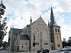 | ||
| farmstead "Keizershof" (former) (nl)(fr) | Bocholt | Kaulillerdorp 24 | 51°11′22″N5°30′59″E / 51.18951°N 5.51644°E | 70753 Info | |||
| village house (nl)(fr) | Bocholt | Kaulillerdorp 38 | 51°11′19″N5°31′03″E / 51.18866°N 5.51753°E | 70754 Info | |||
| rectory (nl)(fr) | Bocholt | Kaulillerdorp 42 | 51°11′17″N5°31′03″E / 51.18804°N 5.51745°E | 70755 Info | |||
| Two village houses (nl)(fr) | Bocholt | Molenstraat 2 | 51°11′20″N5°31′02″E / 51.18878°N 5.51711°E | 70756 Info | |||
| Two village houses (nl)(fr) | Bocholt | Molenstraat 4 | 51°11′20″N5°31′02″E / 51.18878°N 5.51711°E | 70756 Info | |||
| Windmill and miller's house (nl)(fr) | Bocholt | Molenstraat 18 | 51°11′16″N5°30′50″E / 51.18787°N 5.51383°E | 70757 Info | |||
| elongated farm (nl)(fr) | Bocholt | Molenstraat 21 | 51°11′12″N5°30′50″E / 51.18675°N 5.51391°E | 70758 Info | |||
| gunpowder Mill (nl)(fr) | Bocholt | Nevenplein | 51°11′24″N5°31′05″E / 51.18990°N 5.51806°E | 70759 Info | |||
| Farmhouse with separate components (nl)(fr) | Bocholt | Rietweg 33 | 51°10′51″N5°31′25″E / 51.18091°N 5.52365°E | 70760 Info | |||
| "Palmanswijk" (nl)(fr) | Bocholt | Steenweg op Kleine Brogel 36 | 51°11′30″N5°30′44″E / 51.19178°N 5.51216°E | 70761 Info | |||
| "Palmanswijk" (nl)(fr) | Bocholt | Steenweg op Kleine Brogel 38 | 51°11′30″N5°30′44″E / 51.19178°N 5.51216°E | 70761 Info | |||
| "Palmanswijk" (nl)(fr) | Bocholt | Steenweg op Kleine Brogel 40 | 51°11′30″N5°30′44″E / 51.19178°N 5.51216°E | 70761 Info | |||
| "Palmanswijk" (nl)(fr) | Bocholt | Steenweg op Kleine Brogel 42 | 51°11′30″N5°30′44″E / 51.19178°N 5.51216°E | 70761 Info | |||
| "Palmanswijk" (nl)(fr) | Bocholt | Steenweg op Kleine Brogel 44 | 51°11′30″N5°30′44″E / 51.19178°N 5.51216°E | 70761 Info | |||
| "Palmanswijk" (nl)(fr) | Bocholt | Steenweg op Kleine Brogel 46 | 51°11′30″N5°30′44″E / 51.19178°N 5.51216°E | 70761 Info | |||
| "Palmanswijk" (nl)(fr) | Bocholt | Steenweg op Kleine Brogel 48 | 51°11′30″N5°30′44″E / 51.19178°N 5.51216°E | 70761 Info | |||
| "Palmanswijk" (nl)(fr) | Bocholt | Steenweg op Kleine Brogel 50 | 51°11′30″N5°30′44″E / 51.19178°N 5.51216°E | 70761 Info | |||
| "Palmanswijk" (nl)(fr) | Bocholt | Steenweg op Kleine Brogel 52 | 51°11′30″N5°30′44″E / 51.19178°N 5.51216°E | 70761 Info | |||
| "Palmanswijk" (nl)(fr) | Bocholt | Steenweg op Kleine Brogel 54 | 51°11′30″N5°30′44″E / 51.19178°N 5.51216°E | 70761 Info | |||
| "Palmanswijk" (nl)(fr) | Bocholt | Steenweg op Kleine Brogel 56 | 51°11′30″N5°30′44″E / 51.19178°N 5.51216°E | 70761 Info | |||
| "Palmanswijk" (nl)(fr) | Bocholt | Steenweg op Kleine Brogel 58 | 51°11′30″N5°30′44″E / 51.19178°N 5.51216°E | 70761 Info | |||
| "Palmanswijk" (nl)(fr) | Bocholt | Steenweg op Kleine Brogel 60 | 51°11′30″N5°30′44″E / 51.19178°N 5.51216°E | 70761 Info | |||
| "Palmanswijk" (nl)(fr) | Bocholt | Steenweg op Kleine Brogel 62 | 51°11′30″N5°30′44″E / 51.19178°N 5.51216°E | 70761 Info | |||
| "Palmanswijk" (nl)(fr) | Bocholt | Steenweg op Kleine Brogel 64 | 51°11′30″N5°30′44″E / 51.19178°N 5.51216°E | 70761 Info | |||
| "Palmanswijk" (nl)(fr) | Bocholt | Steenweg op Kleine Brogel 66 | 51°11′30″N5°30′44″E / 51.19178°N 5.51216°E | 70761 Info | |||
| "Palmanswijk" (nl)(fr) | Bocholt | Steenweg op Kleine Brogel 68 | 51°11′30″N5°30′44″E / 51.19178°N 5.51216°E | 70761 Info | |||
| L-shaped farmhouse (nl)(fr) | Bocholt | Winterdijkweg 67 | 51°11′18″N5°30′15″E / 51.18824°N 5.50416°E | 70762 Info | |||
| section school (nl)(fr) | Bocholt | Bergerheidestraat 4 | 51°09′19″N5°33′39″E / 51.15534°N 5.56092°E | 70763 Info | |||
| Watermill, "Bink Mill" (nl)(fr) | Bocholt | Binkermolenstraat 1 | 51°09′17″N5°34′19″E / 51.15469°N 5.57186°E | 70764 Info | |||
| Farmhouse with separate components (former) (nl)(fr) | Bocholt | Galgenbergstraat 22 | 51°09′34″N5°33′47″E / 51.15946°N 5.56293°E | 70765 Info | |||
| elongated farm (nl)(fr) | Bocholt | Galgenbergstraat 31 | 51°09′42″N5°33′45″E / 51.16158°N 5.56258°E | 70766 Info | |||
| Chapel of Our Lady of Middelares (nl)(fr) | Bocholt | Grote Baan | 51°08′18″N5°33′26″E / 51.13828°N 5.55722°E | 70767 Info | |||
| Farmstead "Wilbershof" (nl)(fr) | Bocholt | Leukenstraat 2 | 51°09′38″N5°33′38″E / 51.16051°N 5.56043°E | 70768 Info | |||
| Mill Reppel (nl)(fr) | Bocholt | Monshofstraat 9 | 51°09′14″N5°33′29″E / 51.15378°N 5.55819°E | 70770 Info | |||
| rectory (nl)(fr) | Bocholt | Monshofstraat 11 | 51°09′14″N5°33′19″E / 51.15375°N 5.55538°E | 70771 Info | |||
| elongated farm of 1850 (nl)(fr) | Bocholt | Monshofstraat 22 | 51°09′14″N5°33′25″E / 51.15402°N 5.55692°E | 70772 Info | |||
| elongated farm (nl)(fr) | Bocholt | Monshofstraat 30 | 51°09′15″N5°33′11″E / 51.15423°N 5.55317°E | 70773 Info | |||
| Farm "Mons" or "Monshof" (nl)(fr) | Bocholt | Monshofstraat 32 | 51°09′10″N5°32′49″E / 51.15275°N 5.54692°E | 70774 Info | |||
| St. Willibrord Parish (nl)(fr) | Bocholt | Bergerheidestraat 2 | 51°09′17″N5°33′41″E / 51.15481°N 5.56150°E | 70775 Info | 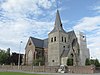 | ||
| Farmstead "Windmill" (nl)(fr) | Bocholt | Reppelerweg 146 | 51°09′08″N5°33′43″E / 51.15234°N 5.56195°E | 70776 Info | |||
| elongated farm (nl)(fr) | Bocholt | Rozenstraat 8 | 51°08′35″N5°32′40″E / 51.14300°N 5.54449°E | 70777 Info | |||
| Building next to the Biotechnicum school (nl)(fr) | Bocholt | Kaulillerweg 5 | 51°10′26″N5°34′36″E / 51.17382°N 5.57653°E | 86024 Info | |||
| Parish Church St. Lawrence (nl)(fr) | Bocholt | Kerkplein | 51°10′21″N5°34′44″E / 51.17251°N 5.57901°E | 86025 Info | 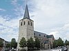 | ||
| Smeetshof farmhouse with separate components (nl)(fr) | Bocholt | Smeetshofweg 1 | 51°11′56″N5°37′58″E / 51.19898°N 5.63268°E | 86026 Info | |||
| section school Kaulille (former) (nl)(fr) | Bocholt | Kaulillerweg 51 | 51°10′30″N5°34′03″E / 51.17488°N 5.56760°E | 86027 Info | |||
| elongated farm (nl)(fr) | Bocholt | Kaulillerweg 167 | 51°10′51″N5°32′13″E / 51.18071°N 5.53681°E | 86028 Info | |||
| Our Lady Chapel (nl)(fr) | Bocholt | Monshofstraat | 51°09′15″N5°33′33″E / 51.15423°N 5.55925°E | 86029 Info | |||
| Our Lady of Lourdes Chapel (nl)(fr) | Bocholt | Monshofstraat | 51°09′15″N5°33′14″E / 51.15405°N 5.55378°E | 86030 Info | |||
| road chapel (nl)(fr) | Bocholt | Reppelerweg | 51°09′27″N5°34′03″E / 51.15762°N 5.56755°E | 86031 Info | |||
| chapel (nl)(fr) | Bocholt | Rozenstraat | 51°08′37″N5°32′37″E / 51.14362°N 5.54357°E | 86032 Info | |||
| cast iron signpost (nl)(fr) | Bocholt | Stramproyerweg | 51°11′00″N5°37′19″E / 51.18335°N 5.62188°E | 88642 Info | |||
| cast Iron cross (nl)(fr) | Bocholt | Bergstraat | 51°09′00″N5°33′51″E / 51.14992°N 5.56421°E | 88643 Info |

