This table shows an overview of the protected heritage sites in the Walloon town Courcelles, Belgium . This list is part of Belgium's national heritage.

Beschermd erfgoed is the official term to describe Flemish National Heritage Sites listed by law to protect and spread awareness of Belgian cultural heritage, specifically in Flanders. The term is also used nationwide to refer to national heritage sites. Because Belgium is officially a tri-lingual country, the other nationwide terms used in the rest of the country are the French term Bien classé and the German term Kulturdenkmal.

Courcelles is a Walloon municipality located in the Belgian province of Hainaut. As of January 1, 2006, Courcelles had a total population of 29,626. The total area is 44.24 km² which gives a population density of 670 inhabitants per km².
| Object | Year/architect | Town/section | Address | Coordinates | Number? | Image |
|---|---|---|---|---|---|---|
| Organs of the church Saint-Lambert (nl)(fr) | Courcelles | 50°27′41″N4°21′50″E / 50.461268°N 4.363794°E | 52015-CLT-0001-01 Info | |||
| Ensemble of the farm of Grand Hamal and surrounding areas (nl)(fr) | Courcelles | 50°28′45″N4°22′44″E / 50.479107°N 4.378923°E | 52015-CLT-0002-01 Info | |||
| Farm Posterie and environment (nl)(fr) | Courcelles | 50°27′45″N4°22′36″E / 50.462530°N 4.376661°E | 52015-CLT-0003-01 Info | |||
| Farm of Grand Hamal: facade and roof (nl)(fr) | Courcelles | 50°28′46″N4°22′49″E / 50.479375°N 4.380285°E | 52015-CLT-0004-01 Info | |||
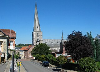
| St. Martin's Church (nl)(fr) | Courcelles | 50°29′12″N4°19′43″E / 50.486557°N 4.328581°E | 52015-CLT-0005-01 Info | |||
| Castle of Trazegnies (nl)(fr) | Courcelles | avenue de la Marlière | 50°27′42″N4°19′48″E / 50.461623°N 4.329934°E | 52015-CLT-0006-01 Info |  | |
| Castle of Trazegnies: park (nl)(fr) | Courcelles | avenue de la Marlière | 50°27′43″N4°19′43″E / 50.461827°N 4.328537°E | 52015-CLT-0007-01 Info | 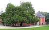 | |
| Castle of Trazegnies: extension of the classification of the remains of the car port overlooking the right of way known as "Avenue Paul Pastur" (nl)(fr) | Courcelles | 50°27′38″N4°19′46″E / 50.460517°N 4.329323°E | 52015-CLT-0008-01 Info | |||
| Church of Saint Martin and the rectory and the ensemble of the church, the old cemetery that surrounds it, the rectory with outbuildings and garden (nl)(fr) | Courcelles | rue Léandre Vilain, n° 17 | 50°28′11″N4°19′46″E / 50.469661°N 4.329549°E | 52015-CLT-0009-01 Info |  | |
| Bird Claire-Fontaine (nl)(fr) | Courcelles | 50°28′56″N4°17′54″E / 50.482162°N 4.298465°E | 52015-CLT-0010-01 Info | |||
| Chapel of the Holy Family (nl)(fr) | Courcelles | rue du Bosquet, avant le n° 52 | 50°28′43″N4°19′43″E / 50.478685°N 4.328720°E | 52015-CLT-0011-01 Info | ||
| Architectural ensemble: some parts of the "Groupe Civique" (nl)(fr) | Courcelles | 50°27′59″N4°19′53″E / 50.466369°N 4.331267°E | 52015-CLT-0016-01 Info | |||
| Rectory of the parish of Saint-Martin (facades and roofs) (nl)(fr) | Courcelles | place communale 1 | 50°29′12″N4°19′45″E / 50.486669°N 4.329129°E | 52015-CLT-0018-01 Info |