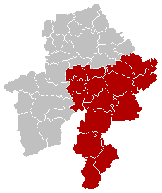
This table shows an overview of the protected heritage sites in the Walloon town Dinant . This list is part of Belgium's national heritage.

Beschermd erfgoed is the official term to describe Flemish National Heritage Sites listed by law to protect and spread awareness of Belgian cultural heritage, specifically in Flanders. The term is also used nationwide to refer to national heritage sites. Because Belgium is officially a tri-lingual country, the other nationwide terms used in the rest of the country are the French term Bien classé and the German term Kulturdenkmal.

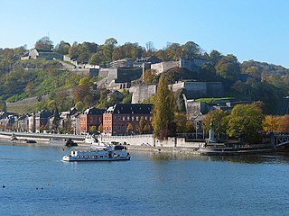
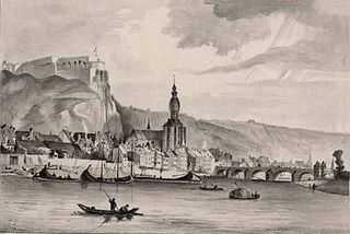
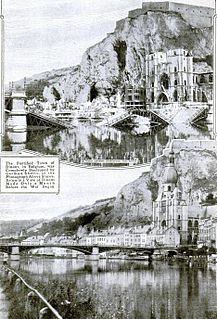
Dinant is a Walloon city and municipality located on the River Meuse, in the Belgian province of Namur. It is around 90 kilometres (56 mi) south-east of Brussels, 30 kilometres (19 mi) south-east of Charleroi, 30 kilometres (19 mi) south of Namur and 20 kilometres (12 mi) north of Givet (France).
| Object | Year/architect | Town/section | Address | Coordinates | Number? | Image |
|---|---|---|---|---|---|---|
| Collegiate Notre-Dame de l'Assomption (nl)(fr) | Dinant | 50°15′40″N4°54′44″E / 50.261070°N 4.912281°E | 91034-CLT-0001-01 Info |  | ||
| Rocks Bayard and surrounding area (nl)(fr) | Dinant | 50°14′40″N4°55′15″E / 50.244542°N 4.920888°E | 91034-CLT-0002-01 Info |  | ||
| Abbey of Leffe (nl)(fr) | Dinant | 50°16′08″N4°54′27″E / 50.268973°N 4.907412°E | 91034-CLT-0003-01 Info |  | ||
| House called "du Pleban" (nl)(fr) | Dinant | rue en Rhée n°89 | 50°15′36″N4°54′50″E / 50.260138°N 4.913751°E | 91034-CLT-0004-01 Info | ||
| Tower building at the corner of the roads rue Cousot and rue Saint-Roch (nl)(fr) | Dinant | 50°15′17″N4°54′55″E / 50.254673°N 4.915317°E | 91034-CLT-0007-01 Info |  | ||
| The parts which constitute the expansion of the classification of the monument of the tower of the building Generet on the corner of the roads rue Cousot and rue Saint-Roch: facades, roofs and the surrounding wall adjacent to the rue Saint-Roch (nl)(fr) | Dinant | 50°15′17″N4°54′56″E / 50.254815°N 4.915575°E | 91034-CLT-0008-01 Info | |||
| Ruins of the old ducal castle and the ensemble of the ruins and surrounding area (nl)(fr) | Dinant | 50°16′18″N4°53′51″E / 50.271538°N 4.897487°E | 91034-CLT-0009-01 Info |  | ||
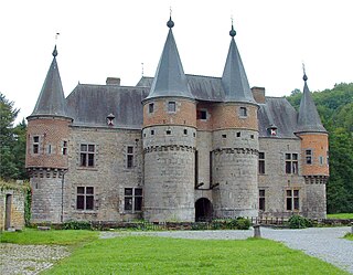
| Castle, former monastery of the Bouillon: facades and roofs (nl)(fr) | Dinant | rue Richiers, n°58 (M) et ensemble formé par ce château et ses abords (S). | 50°16′17″N4°53′55″E / 50.271526°N 4.898537°E | 91034-CLT-0010-01 Info | ||
| House called "The l'Ecolâtre" or "du Marguillier" (nl)(fr) | Dinant | rue Richier n°29 | 50°16′20″N4°53′51″E / 50.272246°N 4.897486°E | 91034-CLT-0011-01 Info | ||
| Gate of Saint-Martin (nl)(fr) | Dinant | 50°15′33″N4°54′46″E / 50.259116°N 4.912750°E | 91034-CLT-0012-01 Info |  | ||
| Hospice Civil, a former Capuchin monastery (old parts) and the ensemble of the building and garden (nl)(fr) | Dinant | 50°15′31″N4°54′41″E / 50.258618°N 4.911322°E | 91034-CLT-0013-01 Info |  | ||
| Rocks of Moniat (nl)(fr) | Dinant | 50°14′33″N4°53′15″E / 50.242558°N 4.887366°E | 91034-CLT-0015-01 Info |  | ||
| Church of Saint-Lambert (nl)(fr) | Dinant | 50°16′21″N4°53′50″E / 50.272427°N 4.897125°E | 91034-CLT-0016-01 Info |  | ||
| Gate of Val (nl)(fr) | Dinant | 50°16′21″N4°53′49″E / 50.272499°N 4.896820°E | 91034-CLT-0017-01 Info |  | ||
| Old rectory of the parish of Saint-Lambert (nl)(fr) | Dinant | rue Richier, n°54 | 50°16′18″N4°53′53″E / 50.271802°N 4.898137°E | 91034-CLT-0021-01 Info | ||
| Church of Notre-Dame (nl)(fr) | Dinant | 50°14′50″N4°59′23″E / 50.247313°N 4.989795°E | 91034-CLT-0023-01 Info |  | ||
| Romanesque crypt and the choir of the old church of Thynes-lez-Dinant, with the chapel in the cemetery (nl)(fr) | Dinant | 50°16′46″N4°59′15″E / 50.279433°N 4.987567°E | 91034-CLT-0027-01 Info | |||
| Chapel of St. Remy and the ensemble of the chapel and its surroundings (nl)(fr) | Dinant | 50°16′03″N5°01′10″E / 50.267588°N 5.019443°E | 91034-CLT-0028-01 Info | |||
| Patrician's house: facades and roofs (nl)(fr) | Dinant | rue Daoust n° 104 | 50°15′05″N4°55′06″E / 50.251515°N 4.918412°E | 91034-CLT-0029-01 Info | ||
| Chapel of Sainte-Ermelinde, furnishings and adjacent square (nl)(fr) | Dinant | rue Richier, links van n°60 | 50°16′15″N4°53′58″E / 50.270968°N 4.899460°E | 91034-CLT-0030-01 Info | ||
| Facades and roofs of the portico and of the café 'au repos du Pèlerin " (nl)(fr) | Dinant | rue de Mahène n°24 | 50°14′49″N4°59′23″E / 50.246941°N 4.989736°E | 91034-CLT-0031-01 Info | ||
| Facades and roofs of farm buildings (nl)(fr) | Dinant | rue du Centre n°s 22 en 23, tegenwoordig rue de Mahène, n°s 22-23 | 50°14′49″N4°59′25″E / 50.246924°N 4.990297°E | 91034-CLT-0032-01 Info | ||
| Calvary, on the classified site of Notre Dame (nl)(fr) | Dinant | 50°14′50″N4°59′23″E / 50.247164°N 4.989658°E | 91034-CLT-0033-01 Info |  | ||
| Fortifications Hauterecenne called "Camp Romain" (nl)(fr) | Dinant | 50°12′39″N4°56′56″E / 50.210849°N 4.948844°E | 91034-CLT-0034-01 Info | |||
| Ensemble of the surroundings of the church Foy-Notre-Dame (nl)(fr) | Dinant | 50°14′50″N4°59′20″E / 50.247111°N 4.988922°E | 91034-CLT-0035-01 Info |  | ||
| House du Peuple: facades and roofs (nl)(fr) | Dinant | place Patenier | 50°15′48″N4°54′37″E / 50.263232°N 4.910297°E | 91034-CLT-0036-01 Info | 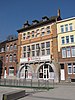 | |
| Rue des Trois Escabelles, from the corner of the Rue des Fosses to the square Saint-Nicolas, including the "Hôtel du Commerce" and the house "Kelner" (nl)(fr) | Dinant | 50°15′24″N4°54′51″E / 50.256547°N 4.914244°E | 91034-CLT-0037-01 Info | |||
| Towers with ramparts and gates of the old city walls: the tower of Saint-Martin (rue de la Grêle) and gate of Corroy (nl)(fr) | Dinant | 50°15′19″N4°55′03″E / 50.255346°N 4.917412°E | 91034-CLT-0038-01 Info | |||
| Old towers of the ramparts and city gates: fortification and four towers (located parallel to the rue Saint-Pierre) (nl)(fr) | Dinant | 50°15′54″N4°54′35″E / 50.264967°N 4.909727°E | 91034-CLT-0039-01 Info |  | ||
| Old towers of the ramparts and the city gates of the tower Empereur, called "Tour Maximilien" (nl)(fr) | Dinant | 50°15′56″N4°54′34″E / 50.265461°N 4.909410°E | 91034-CLT-0040-01 Info | |||
| Ruins of Chateau-Thierry, on the classified site of Cretiats (nl)(fr) | Dinant | 50°12′35″N4°52′31″E / 50.209633°N 4.875408°E | 91034-CLT-0041-01 Info | |||
| House: walls and roofs (nl)(fr) | Dinant | rue Richiers n°40 | 50°16′20″N4°53′52″E / 50.272332°N 4.897803°E | 91034-CLT-0042-01 Info |  | |
| House: walls and roofs (nl)(fr) | Dinant | rue du Bailliage n°18 | 50°16′21″N4°53′53″E / 50.272519°N 4.897958°E | 91034-CLT-0043-01 Info | ||
| House: walls and roofs (nl)(fr) | Dinant | place du Bailliage n°4 | 50°16′22″N4°53′55″E / 50.272799°N 4.898580°E | 91034-CLT-0044-01 Info |  | |
| House: walls and roofs (nl)(fr) | Dinant | place du Bailliage n°22 | 50°16′21″N4°53′52″E / 50.272437°N 4.897797°E | 91034-CLT-0045-01 Info |  | |
| House: walls and roofs (nl)(fr) | Dinant | rue du Fourneau n°7 | 50°16′28″N4°53′47″E / 50.274577°N 4.896309°E | 91034-CLT-0046-01 Info | ||
| House: walls and roofs (nl)(fr) | Dinant | rue Fétis n°68 | 50°16′23″N4°53′54″E / 50.273127°N 4.898446°E | 91034-CLT-0047-01 Info | ||
| House facades, roofs and surrounding wall (nl)(fr) | Dinant | rue des Potiers n°12 | 50°16′19″N4°53′53″E / 50.272061°N 4.898192°E | 91034-CLT-0048-01 Info |  | |
| House: walls and roofs (nl)(fr) | Dinant | rue des Potiers n°s 4-6 | 50°16′20″N4°53′55″E / 50.272187°N 4.898615°E | 91034-CLT-0049-01 Info |  | |
| House: walls and roofs (nl)(fr) | Dinant | rue Cardinal Mercier n°3 | 50°16′22″N4°53′49″E / 50.272831°N 4.896987°E | 91034-CLT-0050-01 Info | ||
| House: walls and roofs (nl)(fr) | Dinant | rue Guiot n°5 | 50°16′24″N4°53′51″E / 50.273313°N 4.897477°E | 91034-CLT-0051-01 Info | ||
| Perpendicular House: façades, roofs and walls surrounding it (nl)(fr) | Dinant | tussen rue Guiot n°3 en rue Génard n°12 | 50°16′24″N4°53′51″E / 50.273350°N 4.897555°E | 91034-CLT-0052-01 Info | ||
| House: walls and roofs (nl)(fr) | Dinant | rue Barbier n°s 3-5 | 50°16′26″N4°53′51″E / 50.273952°N 4.897492°E | 91034-CLT-0053-01 Info | ||
| House: walls and roofs (nl)(fr) | Dinant | place du Bailliage n°24 | 50°16′21″N4°53′52″E / 50.272406°N 4.897724°E | 91034-CLT-0055-01 Info |  | |
| House: walls and roofs (nl)(fr) | Dinant | rue Richier n°41 | 50°16′18″N4°53′53″E / 50.271769°N 4.897944°E | 91034-CLT-0056-01 Info | ||
| House facades, roofs and surrounding wall (nl)(fr) | Dinant | rue Richier n°s 10-14 | 50°16′26″N4°53′49″E / 50.273791°N 4.897083°E | 91034-CLT-0057-01 Info | ||
| House: walls and roofs (nl)(fr) | Dinant | rue Fétis n°74 | 50°16′25″N4°53′53″E / 50.273581°N 4.898120°E | 91034-CLT-0058-01 Info | ||
| Chapel of Notre-Dame de Bonsecours, stone bridge dating from 1767, and 44 guard stones along the road "Bonsecours" (nl)(fr) | Dinant | 50°15′44″N4°54′15″E / 50.262283°N 4.904140°E | 91034-CLT-0059-01 Info | |||
| Church of Saint-Georges (nl)(fr) | Dinant | 50°16′02″N4°54′27″E / 50.267168°N 4.907606°E | 91034-CLT-0060-01 Info | 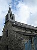 | ||
| Valley of the Meuse between Bouvignes and Houx (nl)(fr) | Dinant | 50°16′25″N4°53′49″E / 50.273744°N 4.896867°E | 91034-CLT-0061-01 Info |  | ||
| Site of the Fonds de Leffe (nl)(fr) | Dinant | 50°16′29″N4°55′16″E / 50.274695°N 4.921145°E | 91034-CLT-0062-01 Info | |||
| Site of Cherau (nl)(fr) | Dinant | 50°16′26″N4°57′30″E / 50.274006°N 4.958235°E | 91034-CLT-0063-01 Info | |||
| Barn: walls and roofs (nl)(fr) | Dinant | route de Furfooz, tegenover n°32 | 50°14′06″N4°56′00″E / 50.234945°N 4.933371°E | 91034-CLT-0064-01 Info | ||
| Facades and roofs between the two round towers on the right of the rock wall of the castle of Walzin, and the facades and roofs of the 15th century tower and the ensemble of the castle of Walzin, the rock "Al penne" with the ruins of Caverenne on its summit, and the boisé La Lesse and part of the alluvial plain (nl)(fr) | Dinant | 50°13′10″N4°55′24″E / 50.219526°N 4.923320°E | 91034-CLT-0065-01 Info |  | ||
| House: walls and roofs (nl)(fr) | Dinant | rue de la Grèle n°15 | 50°15′20″N4°55′02″E / 50.255466°N 4.917137°E | 91034-CLT-0067-01 Info | ||
| House: walls and roofs (nl)(fr) | Dinant | rue Daoust n°53 | 50°15′07″N4°55′04″E / 50.251994°N 4.917722°E | 91034-CLT-0069-01 Info | ||
| The Touriste I and Touriste IV, old tour boats on the Meuse river (nl)(fr) | Dinant | rue Daoust, n°64 | 50°15′10″N4°55′03″E / 50.252868°N 4.917581°E | 91034-CLT-0071-01 Info | ||
| The remains of the ancient northern front of the enclosure of the streets between rue Bouvignes Genard and Rue Barbier, the rocks below Crèvecoeur and the railway (nl)(fr) | Dinant | 50°16′25″N4°53′49″E / 50.273722°N 4.896964°E | 91034-CLT-0072-01 Info |  | ||
| Old house of Bouvignes called "maison espagnole" (nl)(fr) | Dinant | place du Bailliage | 50°16′21″N4°53′53″E / 50.272579°N 4.898056°E | 91034-CLT-0073-01 Info |  | |
| Rocks of Freÿr and surroundings (nl)(fr) | Dinant | 50°12′48″N4°52′36″E / 50.213452°N 4.876657°E | 91034-CLT-0074-01 Info |  | ||
| Site of "la Ranle", "les Traillis" and "les Cretiats" (nl)(fr) | Dinant | 50°12′26″N4°52′53″E / 50.207154°N 4.881300°E | 91034-CLT-0076-01 Info |  | ||
| House: walls and roofs (nl)(fr) | Dinant | rue Richier n°43 | 50°16′18″N4°53′53″E / 50.271723°N 4.898019°E | 91034-CLT-0077-01 Info | ||
| House: walls and roofs (nl)(fr) | Dinant | rue Richier n°45 | 50°16′18″N4°53′53″E / 50.271664°N 4.898065°E | 91034-CLT-0078-01 Info | ||
| Ensemble of the collegiate church of Saint-Perpète, except the organ (instrumental part and buffet) (nl)(fr) | Dinant | 50°15′40″N4°54′44″E / 50.261070°N 4.912281°E | 91034-PEX-0001-01 Info | |||
| The oak ceiling of the church of Notre-Dame (nl)(fr) | Dinant | Foy-Notre-Dame | 50°14′50″N4°59′23″E / 50.247313°N 4.989795°E | 91034-PEX-0002-01 Info | ||
| Fortifications of Hauterecenne called "Camp Romain" (nl)(fr) | Dinant | 50°12′39″N4°56′56″E / 50.210849°N 4.948844°E | 91034-PEX-0003-01 Info | |||
| Valley of the Meuse river between Bouvignes and Houx (nl)(fr) | Dinant | 50°16′25″N4°53′49″E / 50.273744°N 4.896867°E | 91034-PEX-0004-01 Info | |||
| Ensemble of the castle of Walzin, the rock "Al penne" with its summit and the ruins of the Caverenne, and the ensemble of the forest La Lesse and part of the floodplain (nl)(fr) | Dinant | 50°13′21″N4°55′41″E / 50.222394°N 4.928053°E | 91034-PEX-0005-01 Info | |||
| The rocks of Freÿr and the site of Colebi (nl)(fr) | Dinant | 50°14′08″N4°53′33″E / 50.235676°N 4.892521°E | 91034-PEX-0006-01 Info |