This table shows an overview of the protected heritage sites in the Walloon town Durbuy . This list is part of Belgium's national heritage.

Beschermd erfgoed is the official term to describe Flemish National Heritage Sites listed by law to protect and spread awareness of Belgian cultural heritage, specifically in Flanders. The term is also used nationwide to refer to national heritage sites. Because Belgium is officially a tri-lingual country, the other nationwide terms used in the rest of the country are the French term Bien classé and the German term Kulturdenkmal.

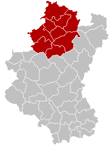
Durbuy is a Walloon city and municipality located in the Belgian province of Luxembourg. The total area is 156.61 km², consisting of the following sub-municipalities: Durbuy proper, Barvaux, Bende, Bomal, Borlon, Grandhan, Heyd, Izier, Septon, Tohogne, Villers-Sainte-Gertrude, and Wéris. On 1 January 2018 the municipality had 11,374 inhabitants with the most populous town of the municipality being Barvaux not Durbuy itself which is known in Belgium as the nation's smallest city.
| Object | Year/architect | Town/section | Address | Coordinates | Number? | Image |
|---|---|---|---|---|---|---|
| The Grain Exchange or Spanish house (nl)(fr) | Durbuy | Durbuy | 50°21′08″N5°27′22″E / 50.352104°N 5.456216°E | 83012-CLT-0001-01 Info |  | |
| The century-old beech tree at a place called "Haie des Veaux" (nl)(fr) | Durbuy | Durbuy | 50°20′47″N5°26′48″E / 50.346340°N 5.446606°E | 83012-CLT-0002-01 Info | ||
| The facades and roofs of buildings (vicarage) (nl)(fr) | Durbuy | rue des Récollets n°38, Durbuy | 50°21′10″N5°27′24″E / 50.352912°N 5.456711°E | 83012-CLT-0003-01 Info | ||
| The facades and roofs of the castle of Bomal (nl)(fr) | Durbuy | Durbuy | 50°22′35″N5°31′18″E / 50.376262°N 5.521730°E | 83012-CLT-0005-01 Info | ||
| Notre Dame (nl)(fr) | Durbuy | Borlon | 50°22′45″N5°24′17″E / 50.379222°N 5.404748°E | 83012-CLT-0007-01 Info |  | |
| Wall around the cemetery of the church of Notre-Dame (nl)(fr) | Durbuy | Durbuy | 50°22′45″N5°24′17″E / 50.379136°N 5.404845°E | 83012-CLT-0008-01 Info | ||
| The old tower, called Justice annexed to the castle of Grandhan (nl)(fr) | Durbuy | Grandhan | 50°19′47″N5°24′31″E / 50.329732°N 5.408607°E | 83012-CLT-0010-01 Info |  | |
| Church of Sainte-Marguerite and the wall of the cemetery of Adrienne Illes, and the ensemble of the church, cemetery and surrounding wall (nl)(fr) | Durbuy | Granhan | 50°19′01″N5°22′43″E / 50.317078°N 5.378623°E | 83012-CLT-0011-01 Info |  | |
| Two lime trees in the locality "Chêne-à-Han", at the intersection of the road and that of Somme-Leuze Enneille-Lamarteau (nl)(fr) | Durbuy | Grandhan | 50°19′54″N5°23′24″E / 50.331732°N 5.390026°E | 83012-CLT-0012-01 Info | ||
| Tower, the walls and roofs of the main building of the castle of Izier, and the ensemble of the tower, main building, the farmhouse and courtyard, and the plot next to the gate of the buildings (nl)(fr) | Durbuy | 50°23′00″N5°34′49″E / 50.383462°N 5.580395°E | 83012-CLT-0013-01 Info |  | ||
| St. Martin's Church (nl)(fr) | Durbuy | Tohogne | 50°22′49″N5°28′50″E / 50.380183°N 5.480436°E | 83012-CLT-0014-01 Info |  | |
| Chapel (unused) (nl)(fr) | Durbuy | place Vendôme, rechts van n°44 | 50°24′06″N5°30′44″E / 50.401702°N 5.512135°E | 83012-CLT-0015-01 Info | ||
| Building in Tohogne (nl)(fr) | Durbuy | rue de Presseux | 50°22′53″N5°28′47″E / 50.381271°N 5.479585°E | 83012-CLT-0017-01 Info | ||
| Church Sainte Walburge (nl)(fr) | Durbuy | Wéris | 50°19′36″N5°31′50″E / 50.326551°N 5.530436°E | 83012-CLT-0018-01 Info |  | |
| Dolmens in the territory of the village Wéris (nl)(fr) | Durbuy | Wéris | 50°20′00″N5°31′22″E / 50.333377°N 5.522700°E | 83012-CLT-0019-01 Info |  | |
| Ensemble of the church and the fortified house of Wéris (nl)(fr) | Durbuy | Wéris | 50°19′35″N5°31′47″E / 50.326428°N 5.529827°E | 83012-CLT-0020-01 Info | ||
| Oldest parts of the city walls (nl)(fr) | Durbuy | Durbuy | 50°21′07″N5°27′28″E / 50.352040°N 5.457713°E | 83012-CLT-0022-01 Info | ||
| The facades and roofs of the house Legros (nl)(fr) | Durbuy | Durbuy | 50°21′03″N5°29′38″E / 50.350941°N 5.493804°E | 83012-CLT-0023-01 Info |  | |
| The facades and roofs of the chapel in M. Paridaens, and the panels in the interior of the building, and the ensemble of the chapel and its surroundings (nl)(fr) | Durbuy | Durbuy | 50°25′10″N5°24′53″E / 50.419313°N 5.414682°E | 83012-CLT-0024-01 Info | ||
| Chapel of Saint-Denis (nl)(fr) | Durbuy | Juzaine | 50°22′13″N5°32′03″E / 50.370250°N 5.534069°E | 83012-CLT-0026-01 Info | 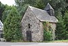 | |
| The facades and roofs of the building "La Poivrière" (nl)(fr) | Durbuy | Grand-Rue n°28, Durbuy | 50°21′02″N5°29′40″E / 50.350667°N 5.494417°E | 83012-CLT-0027-01 Info | 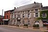 | |
| Old Manse: facades and roofs (nl)(fr) | Durbuy | rue de Liège, links van n°29 | 50°22′45″N5°31′24″E / 50.379125°N 5.523317°E | 83012-CLT-0028-01 Info | ||
| Mont Saint Rahy (nl)(fr) | Durbuy | Bomal | 50°23′04″N5°32′28″E / 50.384403°N 5.541104°E | 83012-CLT-0029-01 Info | ||
| The "Grandes Roches" (nl)(fr) | Durbuy | Bomal | 50°22′40″N5°31′44″E / 50.377741°N 5.528943°E | 83012-CLT-0030-01 Info | ||
| Ensemble of the chapel of Sainte-Geneviève, the linden trees and grassland around them (nl)(fr) | Durbuy | Izier | 50°22′57″N5°35′15″E / 50.382415°N 5.587560°E | 83012-CLT-0031-01 Info | ||
| The "Longue Haye", including the country road called "Voye du Juzaine" and the two towns called "Calvary" and "Longue Haye" (nl)(fr) | Durbuy | Ozo | 50°22′07″N5°32′17″E / 50.368501°N 5.538140°E | 83012-CLT-0035-01 Info | ||
| The facades and roofs of the building (Institut Clairval) (nl)(fr) | Durbuy | rue des Récollets n°39, Durbuy | 50°21′11″N5°27′25″E / 50.353131°N 5.457000°E | 83012-CLT-0036-01 Info | ||
| Old Grain Exchange (nl)(fr) | Durbuy | 50°21′08″N5°27′22″E / 50.352104°N 5.456216°E | 83012-PEX-0001-01 Info | |||
| Murals from the 16th and 17th centuries of the church of Saint-Martin (nl)(fr) | Durbuy | Tohogne | 50°22′49″N5°28′50″E / 50.380183°N 5.480436°E | 83012-PEX-0002-01 Info | ||
| The northern Dolmen (nl)(fr) | Durbuy | Wéris | 50°20′00″N5°31′22″E / 50.333377°N 5.522700°E | 83012-PEX-0003-01 Info |